

LANDSLIDE SUSCEPTIBILITY ASSESSMENT IN THE THREE GORGES AREA, CHINA, ZIGUI SYNCLINAL BASIN, USING GIS TECHNOLOGY AND FREQUENCY RATIO MODEL
-
摘要: 以三峡地区秭归向斜盆地为研究区,在野外滑坡编图的基础上,选择地形坡度、地层岩性、河流、道路、坡向、坡型结构6个因子参与滑坡敏感性评价,运用GIS空间分析技术,引入频率比模型,分别计算评价因子的贡献率,并进行叠加分析,最终划分为4个敏感性分区。评价结果表明:极高敏感性区面积占21.39%,滑坡发生面积占61.44%;高敏感性分区面积占24.99%,滑坡发生面积占21.67%;中敏感性分区面积占30.66%,滑坡发生面积占13.19%;低敏感性分区面积占22.93%,滑坡发生面积占3.69%。滑坡敏感性面积累计百分比曲线图表明评价结果具有较高的准确度和可靠性。研究成果可为政府部门减灾防灾工程提供科学支持,为滑坡灾害的预测和管理提供科学依据。Abstract: The Three Gorgesarea, China, Zigui synclinal basin is selected as a case study in this paper. Based on the field of landslide mapping, in the frequency ratio model, slope angle, lithology, rivers, roads, aspect and beeding-aspect this six assessment factors are considered to assess landslide susceptibility by overlaying analysis using GIS technology to calculate the contribution rate separately, Ultimately, landslide susceptibility area is divided into four partitions. The results shows that the vey high susceptibility area accounts for 21.39 percent and landslide area accounts for 61.44 percent. high susceptibility area accounts for 24.99 percent and landslide area accounts for 21.67 percent. Moderate susceptibility area accounts for 30.66 percent and landslide area accounts for13.19 percent. Low susceptibility area accounts for 22.93 percent and landslide area accounts for 3.69 percent. The cumulative percentage curve of landslide susceptibility area shows that the results are highly accurant and reliable, what to provide scientific support for the government about disaster prevention and reducing engineering, and provide scientific basis to landslide forecast and management.
-

图 11 滑坡敏感性分区面积与滑坡发生面积百分比
Figure 11. The percentage histogram between zoning area of landslide susceptibility and landslide area

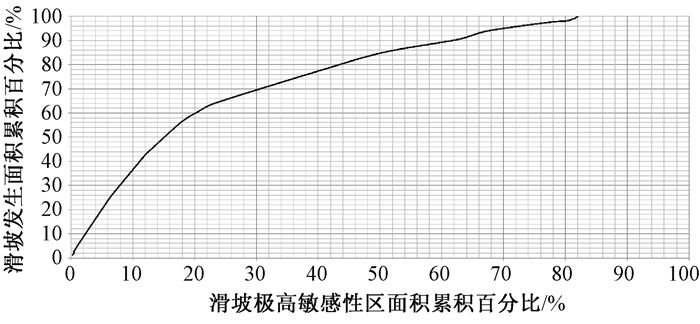
图 12 频率比模型法滑坡敏感性面积累计百分比曲线图
Figure 12. Requency ratio model shows cumulative percentage curve of landslide sensitive area
表 1 滑坡敏感性频率比值
Table 1. Frequency ratio of landslide susceptibility
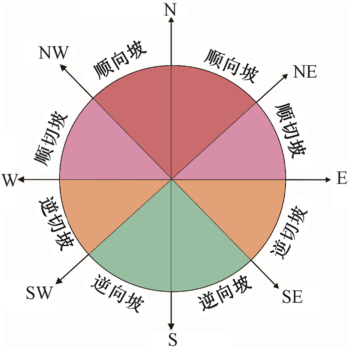
敏感性评价因子 分类 滑坡面积/km 2 滑坡面积百分比/% 子因子面积/km2 子因子面积百分比/% 频率比 地形坡度 0~10° 1.53 6.45 24.91 5.65 1.14 10~20° 7.70 32.51 86.40 19.60 1.66 20~30° 9.28 39.20 145.34 32.97 1.19 30~40° 4.16 17.55 120.08 27.24 0.64 40~50° 0.88 3.72 52.77 11.97 0.31 50~60° 0.13 0.56 10.70 2.43 0.23 > 60° 0.00 0.01 0.64 0.14 0.05 地层岩组 第四系 0.46 1.95 1.87 0.42 4.59 蓬莱镇组 12.11 51.18 94.96 21.54 2.38 遂宁组 3.11 13.15 85.46 19.38 0.68 沙溪庙组二段 1.87 7.89 83.29 18.89 0.42 沙溪庙组一段 2.06 8.70 103.40 23.45 0.37 聂家山组 1.21 5.11 36.52 8.28 0.62 筒竹园组 0.84 3.57 7.19 1.63 2.18 沙镇溪组 0.33 1.38 3.08 0.70 1.97 巴东组三四段 0.94 3.98 8.62 1.95 2.03 巴东组二段 0.58 2.45 6.95 1.58 1.55 巴东组一段 0.00 0.00 1.81 0.41 0.00 坡向 Flat 0 0 0.34 0.08 0 N 2.10 8.87 46.57 10.56 0.84 NE 3.07 12.99 60.38 13.70 0.95 E 4.69 19.81 65.16 14.78 1.34 SE 4.66 19.70 69.23 15.70 1.25 S 2.56 10.80 51.49 11.68 0.93 SW 1.52 6.43 44.20 10.03 0.64 W 3.31 13.97 58.81 13.34 1.05 NW 1.76 7.43 44.67 10.13 0.73 河流Buffer < 500 m 11.06 46.73 129.95 29.48 1.59 500~1000 m 6.47 27.33 98.87 22.43 1.22 1000~1500 m 2.98 12.60 74.68 16.94 0.74 1500~2000 m 2.00 8.45 47.70 10.82 0.78 > 2000 m 1.16 4.89 89.65 20.34 0.24 道路Buffer < 500 m 12.06 50.94 123.88 28.10 1.81 500~1000 m 5.77 24.37 83.73 18.99 1.28 1000~1500 m 3.17 13.41 63.02 14.29 0.94 1500~2000 m 1.14 4.84 48.60 11.02 0.44 > 2000 m 1.53 6.45 121.61 27.59 0.23 斜坡结构 逆向坡 0.60 0.60 0.60 0.60 0.60 逆切坡 0.60 0.60 0.60 0.60 0.60 顺切坡 1.05 1.05 1.05 1.05 1.05 顺向坡 1.48 1.48 1.48 1.48 1.48  下载: 导出CSV
表 2 滑坡敏感性评价结果
Table 2. Resultsof landslidesusceptibility
敏感性分区 滑坡发生面积/km2 滑坡发生面积占比/% 敏感性分区面积/km2 敏感性分区面积占比/% 比率 低敏感性区 0.87 3.69 101.06 22.93 0.16 中敏感性区 3.12 13.19 135.25 30.69 0.43 高敏感性区 5.13 21.67 110.12 24.99 0.87 极高敏感性区 14.55 61.44 94.26 21.39 2.87
下载: 导出CSV
-
[1] Aleotti P, Chowdhury R. Landslide hazard assessment: Summary review and new perspectives[J]. Bulletin of Engineering Geology and the Environment, 1999, 58(1): 21~44. doi: 10.1007/s100640050066 [2] Saha A K, Gupta R P, Sarkar I, et al. An approach for GIS-based statisticallandslidesusceptibility zonation: Witha case study in the Himalayas[J]. Landslides, 2005, 2(1): 61~69. doi: 10.1007/s10346-004-0039~8 [3] Fell R, Corominas J, Bonnard C, et al. Guidelines for landslide susceptibility, hazard and risk zoning for land-use planning[J]. Engineering Geology, 2008, 102(3/4): 99~111. http://www.sciencedirect.com/science/article/pii/S0013795208001762 [4] Guzzetti F, Carrarra A, Cardinali M, et al. Landslide hazard evaluation: A review of current techniques and their application in a multiscale study, Central Italy[J]. Geomorphology, 1999, 31:181~216. doi: 10.1016/S0169~555X(99)00078~1 [5] Rowbotham D, DudychaD N. GIS modeling of slope stability in PhewaTal watershed, Nepal[J]. Geomorphology, 1998, 26:151~170. doi: 10.1016/S0169~555X(98)00056~7 [6] Lee S, Min K. Statistical analysis of landslide susceptibility at Yongin, Korea[J]. Environ Geol, 2001, 40:1095~1113. doi: 10.1007/s002540100310 [7] DonatiL, Turrini M C. An objective method to rank the importance of the factors predisposing to landslides with the GIS methodology: Application to an area of the Apennines (Valnerina, Perugia, Italy)[J]. Eng Geol, 2002, 63: 277~289. doi: 10.1016/S0013~7952(01)00087~4 [8] Lee S, Choi U. Development of GIS-based geological hazard information system and its application for landslide analysis in Korea[J]. Geosci J, 2003, 7: 243~252. doi: 10.1007/BF02910291 [9] Atkinson P M, Massari R. Generalized linear modeling of susceptibility to landsliding in the central Apennines, Italy[J]. Computers & Geosciences, 1998, 24(4): 373~385. https://eprints.soton.ac.uk/17340/ [10] Dai F C, Lee C F, Li J, et al. Assessment of landslides susceptibility on the natural terrain of Lantau Island, Hongkong[J]. Environ Geol, 2001, 40: 381~391. doi: 10.1007/s002540000163 [11] Dai F C, Lee C F. Landslide characteristics and slope instability modeling using GIS, Lantau Island, Hongkong[J]. Geomorphology, 2002, 42: 213~228. doi: 10.1016/S0169~555X(01)00087~3 [12] 唐川, 朱静.GIS支持下的地震诱发滑坡危险区预测研究[J].地震研究, 2001, 24(1): 73~81. http://www.cnki.com.cn/Article/CJFDTOTAL-DZYJ200101011.htmTANG Chuan, ZHU Jing. GIS based earthquake triggered landslide hazard prediction[J]. Journal of Seismological Research, 2001, 24(1): 73~81. http://www.cnki.com.cn/Article/CJFDTOTAL-DZYJ200101011.htm [13] 许冲, 戴福初, 姚鑫, 等.基于GIS与确定性系数分析方法的汶川地震滑坡易发性评价[J].工程地质学报, 2010, 18(1): 15~26. http://www.cnki.com.cn/Article/CJFDTOTAL-GCDZ201001003.htmXU Chong, DAI Fu-chu, YAO Xin, et al. GIS platform and certainty factor analysis method based Wenchuan earthquake-induced landslide susceptibility evaluation[J]. Journal of Engineering Geology, 2010, 18(1): 15~26. http://www.cnki.com.cn/Article/CJFDTOTAL-GCDZ201001003.htm [14] 兰恒星, 伍法权, 周成虎, 等.基于GIS的云南小江流域滑坡因子敏感性分析[J].岩石力学与工程学报, 2002, 21(10): 1500~1506. doi: 10.3321/j.issn:1000~6915.2002.10.014LAN Heng-xing, WU Fa-quan, ZHOU Cheng-hu, et al. Analysis on susceptibility of GIS based landslide triggering factors in Yunnan Xiaojiang watershed[J]. Chinese Journal of Rock Mechanics and Engineering, 2002, 21(10): 1500~1506. doi: 10.3321/j.issn:1000~6915.2002.10.014 [15] Maharaj R J. Landslide processes and landslide susceptibility analysis from an upland watershed: A case study from St. Andrew, Jamaica, WestIndies[J]. Engineering Geology, 1993, 34(1/2):53~79. http://www.sciencedirect.com/science/article/pii/001379529390043C [16] Kamp U, Growley B J, Khattak G A, et al. GIS based landslide susceptibility mapping for the 2005 Kashmir earthquake region[J]. Geomorphology, 2008, 101(4): 631~642. doi: 10.1016/j.geomorph.2008.03.003 [17] Tang C, Zhu J, Li W, et al. Rainfall-triggered debris flows following the Wenchuan earthquake[J]. Bulletin of Engineering Geology and the Environment, 2009, 68(2): 187~194. doi: 10.1007/s10064-009-0201~6 [18] Carrara A, Guzzetti F, Cardinali M, et al. Use of GIS technology in the prediction and monitoring of landslide hazard[J]. Natural Hazards, 1999, 20(2/3): 117~135,5. doi: 10.1023/A:1008097111310 [19] Kouli M, Loupasakis C, Soupios P, et al. Landslide hazard zonation in high risk areas of Rethymno Prefecture, Crete Island, Greece[J]. Natural Hazards, 2010, 52(3): 599~621. doi: 10.1007/s11069-009~9403~2 -

 下载:
下载:


计量
- 文章访问数: 318
- HTML全文浏览量: 240
- PDF下载量: 17
- 被引次数: 0
