LATITUDINAL CONVERGENCE OF THE ASIAN CONTINENT, RISE OF THE QINGHAI-TIBET PLATEAU AND EXPANSION OF THE EAST ASIAN CONTINENT
-
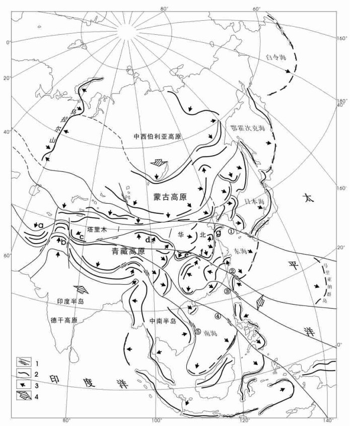
摘要: 东亚大地构造问题是世界瞩目的焦点之一。区内有蒙古和青藏两个雄伟的高原屹立, 二者之间分布着天山—阴山和昆仑—秦岭等横亘东西的现代山系, 它们由一系列剪切-推覆构造系统组成, 有力地说明东亚大陆存在强烈的纬向汇聚。在此以东, 总体构造面貌向SE呈扩张发散态势, 南达赤道以南的印度尼西亚群岛, 向东可能涉及马里亚纳岛弧。一系列弧形构造是推覆-拉伸构造岩片的前缘挤压逆冲推覆-隆起增厚构造带, 后方常伴有拉伸滑脱-沉降减薄盆地, 并显示着陆壳表层的运动方向。东亚大陆现今构造面貌是新生代以来喜山运动产物, 这一过程迄今还在进行。它不仅对东亚地质构造和地震分布规律以及资源环境问题有重要影响, 而且与大气环流形成及气候环境变化有密切关系。Abstract: The tectonic problem of East Asia is one of the focuses of the world's concern. In East Asia stand two magnificent plateaus —the Mongolia Plateau and Qinghai-Tibet Plateau —and between the two plateaus lie E-W-trending modern mountain systems such as the Tianshan-Yinshan and Kunlun-Qinling mountain systems, which consist of a series of shear-overthrusting tectonic systems, powerfully suggesting the occurrence of strong latitudinal convergence in the East Asian continent. East of the aforesaid region the general tectonic features show trends of expansion and divergence toward the SE. Southward they reach the Indonesia Islands south of the equator and eastward they might involve the Mariana island arc. A series of arcuate structures are tectonic belts formed by frontal compression, overthrusting, uplift and thickening of the overthrusting-extensional slabs and behind these arcuate structures there usually occur extensional and detachment-subsidence and thinning basins, which show the directions of movements of the continental crustal surface. The present tectonic features of the East Asian continent are the product of the Himalayan movement since the Cenozoic and this process is now still going on. It not only has exerted important influence on the geological structure and tectonics, distribution characteristics of earthquakes and resources and environmental problems, but also are closely related to the formation of the atmospheric circulation and climatic and environmental changes.
-
[1] 李四光.受了歪曲的亚洲大陆[J].地质论评, 1951, 16(1):1~5. doi: 10.3321/j.issn:0371-5736.1951.01.001 [2] 中国地质科学院地质力学研究所主编.1: 250万中华人民共和国及其毗邻海区构造体系图.北京:地图出版社, 1984. [3] 地质矿产部地质力学研究所.中国分省构造体系研究文集.第1辑[M].北京:地质出版社, 1985. [4] 地质矿产部地质力学研究所.中国分省构造体系研究文集.第2辑[M].北京:地质出版社, 1985. [5] 李述靖, 张维杰, 等.蒙古弧地质构造特征及形成演化概论[M].北京:地质出版社, 1998. [6] 李述靖. 中国云南兰坪—思茅喜马拉雅期褶皱带构造特征及其形成机制和构造意义[M]. 中国地质科学院地质力学研究所所刊(16). 北京: 地质出版社, 1995, 1~12. [7] 程浴淇主编.中国区域地质概论[M].北京:地质出版社, 1994. [8] 马杏垣, 等.中国及邻近海域岩石圈动力学图.北京:地质出版社, 1986. [9] 马杏垣, 等.中国岩石圈动力学纲要[M].北京:地质出版社, 1987. [10] 中国地质调查局成都地质矿产研究所.1: 150万青藏高原及邻区地质图.成都:成都地图出版社, 2004. [11] 李述靖, 郑达兴.遥感构造解析与地壳表层结构构造型式[J].地质力学学报, 2006, 12(3):279~286. doi: 10.3969/j.issn.1006-6616.2006.03.001 [12] 刘刚, 李述靖, 赵福岳, 等.阿尔金—康西瓦剪切—推覆系统和帕米尔推覆构造的遥感解析[J].地球学报, 2006, 27(1):25~29. doi: 10.3321/j.issn:1006-3021.2006.01.003 [13] 阿尔金活动断裂带课题组.阿尔金活动断裂带[M].北京:地震出版社, 1992. [14] 王小凤, 等.郯庐断裂带[M].北京:地质出版社, 2000. [15] 孙武城, 徐杰, 杨平恩, 等.上海奉贤至内蒙古阿拉善左旗地学断面[M].北京:地震出版社, 1991. [16] 王连庆, 徐刚.青藏铁路格尔木—唐古拉山口段主要线性构造ETM影像特征[J].地球学报, 2002, 23(4):349 ~352. doi: 10.3321/j.issn:1006-3021.2002.04.011 [17] 崔作舟, 等.青藏高原速度结构和深部构造[M].北京:地质出版社, 1992. [18] 张中杰, 等.中国大陆地球深部结构与动力学研究[M].北京:科学出版社, 2004. [19] 杨文采, 等.苏鲁大别造山带地球物理与壳幔作用[M].北京:地质出版社, 2005. [20] 朱介寿, 等.中国华南及东海地区岩石圈三维结构及演化[M].北京:地质出版社, 2005. [21] 高锐, 肖序常, 等.新疆地学断面深地震反射剖面揭示的西昆仑—塔里木结合带岩石圈结构[J].地球学报, 2001, 22(6):547~552. doi: 10.3321/j.issn:1006-3021.2001.06.013 [22] 马杏垣, 刘昌铨, 刘国栋.江苏响水至内蒙古满多拉地学断面[M].北京:地质出版社, 1991. [23] 卢造勋, 夏怀宽.内蒙古东乌穆沁旗—辽宁东沟地学断面[J].地球物理学报, 1993, 36(6):765~772. doi: 10.3321/j.issn:0001-5733.1993.06.008 [24] 袁学城主编.阿尔泰~台湾地学断面论文集[M].武汉:中国地质大学出版社, 1997. [25] 崔作舟, 李秋生, 孟令顺, 等.格尔木—额齐纳旗岩石圈结构与深部构造[M].北京:地质出版社, 1999. [26] 马杏垣, 等.中国岩石圈动力学地图集[M].北京:中国地图出版社, 1989. [27] 郑度, 等.青藏高原隆升与环境效应[M].北京:科学出版社, 2004. -


 下载:
下载:

