

DISCUSSION ON THE SCALE PROBLEM IN REMOTE SENSING DATA FOR LOESS LANDSLIDE SURVEY IN BAOJI, SHAANXI PROVINCE, CHIAN
-
摘要: 遥感数据的尺度效应决定了可识别内容与识别精度,同-区域内的遥感数据尺度不同,同样的遥感处理模型或者方法将得到不同的处理结果。以宝鸡黄土区滑坡遥感调查为基础,对不同遥感数据源的滑坡体的最小可识别面积、图斑面积精度测算、最佳及最大成图比例尺、遥感地质灾害解译对比性分析、滑坡遥感解译精度评价等等与遥感尺度有密切关系的问题进行了探讨。研究结果表明,在宝鸡黄土区,调查大、中型以上滑坡的信息,可以采用SPOT-5(2.5 m)融合图像数据,比例尺为1:25000或1:50000;调查中型、小型滑坡及较大滑坡体内部结构定量信息,可以采用QuickBird(0.61 m)融合图像数据,比例尺为1:5000。Abstract: The content and accuracy are determined by the scale of remote sensing(RS) data, the RS Processing molds or methods vary with Remote sensing data scale in the same region. Based on the landslide RS survey in Baoji loess area, we discuss the problems that have great relationship with RS scale, such as Mininum regional area of landslide mass in different RS data source, precision measurement of spot area, the best and maxinum mapping scale, comparative analysis of interpretation of RS geological hazards, accuracy evaluation of landslide RS interpretation and so on. The result reveals that when investgating large and medium-sized landslide in Baoji loess area, SPOT-5(2.5 m)Fused image data can be used, and the scale is 1:25000 or 1:50000. Meanwhile, QuickBird(0.61m)Fused image data is used for medium-small landslide and quantitative information calculation on the internal structure of larger landslide, and the scale is 1:5000.
-
Key words:
- Loess Landslide /
- Remote Sensing Data /
- Scale in Remote Sensing /
- Precision Problem /
- Object Identity
-

图 2 成图比例尺与遥感数据空间分辨率的需求关系图
Figure 2. Requirement relation graph of the Remote Sensing Images Spatial Resolution and Mapping Scale

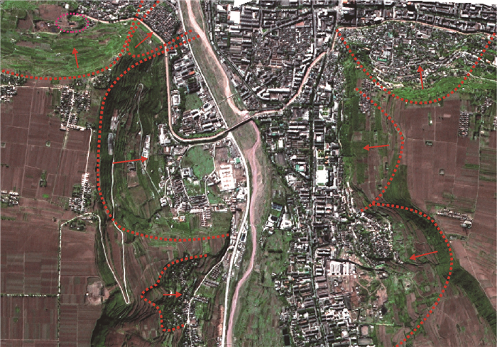
图 3 2.5 m空间分辨率图像(Spot-5)
Figure 3. Remote Sensing Image of 2.5 m spatial resolution (Spot-5)

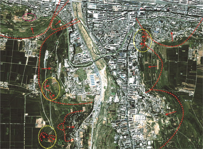
图 4 0.61 m空间分辨率图像(QuickBird)
Figure 4. Remote Sensing Image of 0.61m spatial resolution (QuickBird)
表 1 不同遥感数据源可识别的最小地物的面积统计
Table 1. minimum recognition area of ground object in different remote sensing data source
名称 遥感数据类型 遥感数据空间分辨率/m 最小可识别图斑面积/m2 1 Worldview-2(Pan) 0.46 5.29 2 QuickBird(Pan) 0.61 9.30 3 Ikonos (Pan) 1 25.00 4 Worldview-2(Multi) 1.8 81.00 5 CBERS_2B(Pan) 2.35 138.06 6 QuickBird(Multi) 2.44 148.84 7 Spot-5(Pan) 2.5 156.25 8 Ikonos(Multi) 4 400.00 9 Spot-5(Pan) 5 625.00 10 Spot-4(Multi) 10 2500.00 11 ASTER/ETM +(Pan) 15 5625.00 12 CBERS_1/2(Multi) 19.5 9506.25 13 ASTER/ETM +/TM(Multi) 30 22500.00 14 MSS(Multi) 60 90000.00  下载: 导出CSV
表 2 滑坡图斑的面积测量精度评价
Table 2. Precision evaluation of landslide area measurement
滑坡编号 滑坡规模 QuickBird图斑面积/m 2 Spot-5图斑面积/m 2 实测滑坡面积/m 2 QuickBird面积相差/% Spot-5面积相差/% W85h 小型 14878.76543 14557.94588 14730.02208 1.01 -1.17 W86h 小型 7697.85468 7684.02001 7819.97130 -1.56 -1.74 W87h 小型 6213.63471 6125.50292 6296.48522 -1.32 -2.72 W88h 小型 10598.44376 10595.98615 10707.56306 -1.02 -1.04 W92h 中型 32767.1278 32889.21906 32798.87048 -0.09 0.28 W93h 中型 32033.3882 32055.4995 32098.20898 -0.20 -0.13 W94h 中型 72088.33562 72090.10256 72076.67921 0.02 0.02 W100h 小型 9407.02375 9397.01667 9509.76230 -1.08 -1.19 W101h 小型 15685.48206 15675.4913 15828.34280 -0.90 -0.97 W102h 中型 23898.67251 23977.35417 23845.79218 0.22 0.55 W103h 中型 23896.70854 23771.60617 23663.00792 0.99 0.46 W104h 中型 28684.0043 28446.60221 28591.10986 0.32 -0.51 W105h 中型 35570.23072 35408.18705 35379.72682 0.54 0.08 W106h 大型 104098.0521 104087.0398 104128.08740 -0.03 -0.04
下载: 导出CSV
表 3 比例尺精度(D)
Table 3. Precision of Mapping Scale(D)
比例尺 精度/m L1=0.1 mm L2=0.2 mm 1:10 000 1 2 1:50 000 5 10 1:100 000 10 20 1:250 000 25 50 1:500 000 50 100 1:1 000 000 100 200
下载: 导出CSV
表 4 不同遥感数据源适于制图精度的比例尺对比表
Table 4. The adaptability analysis to the Remote Sensing Data Source and Mapping Scale
遥感数据类型 分类 遥感数据空间分辨率/m 可制图比例尺/M 最佳成图比例尺/M(按国家标准分幅) L1=0.1 mm L2=0.2 mm Worldview-2(Pan) 高分辨率 0.46 4600 2300 2500 QuickBird(Multi) 0.61 6100 3050 5000 Ikonos(Pan) 1 10000 5000 5000或10000 Worldview-2(Multi) 中高分辨率 1.8 18000 9000 10000 CBERS_2B(Pan) 2.35 23500 11750 25000 QuickBird(Multi) 2.44 24400 12200 25000 Spot(Pan) 2.5 25000 12500 25000 Ikonos (Multi) 4 40000 20000 25000 Spot-5(Pan) 5 50000 25000 25000或50000 Spot-4(Multi) 中分辨率 10 100000 50000 50000或10000 ASTER/ETM+(Pan) 15 150000 75000 10000 CBERS_1/2(Multi) 19.5 195000 97500 10000 ASTER/ETM+/TM(Multi) 30 300000 150000 250000 MSS(Multi) 60 600000 300000 500000
下载: 导出CSV
表 5 不同数据源遥感解译对比分析
Table 5. Contrasting Analysis of Different Data Sources Interpretation Results
数据源 可解译内容 优、缺点 适宜提取的信息 中等分辨率数据:
MSS(Multi)_60 m;
ASTER/ETM+/TM(Multi)_30 m;
CBERS_1/2(Multi) _19.5 m;
ASTER/ETM+(Pan)_15 m;
Spot-4、5(Multi) _10 m;可区分丘陵、盆地、基岩山区等不同的地貌单元,可分出较大黄土塬、梁、峁;可解译特大型、巨型滑坡灾害;识别居住区与农田及植被覆盖区 价格较低,幅度宽,覆盖面积广;波段数多、可以不同波段组合;进行3D可视性分析,可用SRTM_90 m和1:50000_25 m的DEM与遥感数据进行很好的套合;但其分辨率低,只能识别较大的地物 区域地形、地貌特征,线、环构造解译,区域性岩石组合的识别等地质环境背景信息提取研究,可解译特大型、巨型滑坡的轮廓;适合小于1:50000的区域滑坡地质灾害遥感调查 中高空间分辨率数据:
GF-1(Multi)_8 m;
GF-1(Pan)_2 m;
GF-2(Multi)_4 m;
Ikonos(Multi) _4 m;
Spot-5(Pan)_5 m;
Spot-5(Pan)_2.5 m;
Spot-6、7(Pan)_1.5 m;
QuickBird(Multi) _2.44 m;
ZY-1_2C(Pan)_2.36 m;
Worldview-2(Multi) _1.8 m;可识别黄土塬、梁、峁;解译大、中型滑坡;可识别滑坡体内与邻近区域不协调的网纹结构;可对城镇房屋、道路等进行识别 性价比合适;覆盖幅度较大;是地质灾害遥感调查最适合的数据源;进行3D可视性分析,可用1:50000_25 m和1:10000_5 m的DEM与遥感数据进行套合,但套合精度有限;该类波段较少、分辨率适中 滑坡灾害定性解译分析,是滑坡遥感调查最适合的数据源;适合大、中型滑坡的轮廓信息识别。适合1:10000到1:50000的大、中型滑坡地质灾害遥感调查 高空间分辨率数据:
GF-2(Pan)_1 m;
Ikonos(Pan)_1 m;
QuickBird(Multi) _0.61 m;
Worldview-2(Pan)_0.46 m解译中、小型滑坡;测量滑坡标志层的位移量;可识别滑坡体内部与邻近区域不协调的网纹结构,后缘弧形异常影像,包括陡坎、地形变异线和色调异常线等,滑坡体两侧自然沟切割较深,前缘向谷地凸起及小型崩滑堆积影像;识别大型车辆、乡村房屋 价格较高;覆盖幅度较小;可进行遥感定量分析;进行3D可视性分析,需要大于1:10000_5m的DEM与遥感数据进行套合,但套合精度很难达到;该类波段少、分辨率较高 滑坡灾害定量解译分析,是滑坡体内部结构详细信息调查的数据源;但由于内部的纹理信息详细,而滑坡的轮廓信息不如上面数据源的效果好。适合大于1:10000滑坡灾害遥感调查
下载: 导出CSV
表 6 宝鸡市Spot-5与QuickBird遥感解译滑坡点精度(单位:个)评价一览表
Table 6. The accuracy evaluation of Spot-5 and QuickBird on Landslide sites in the study region
类型 野外调查滑坡点数 遥感数据滑坡信息显示数 遥感数据源显示滑坡信息的精度 专业人员遥感解译误判数 专业人员遥感解译漏判数 专业人员遥感解译正确数 专业人员遥感解译精度 Spot-5 遥感数据源评价 349 297 85.10% 专业人员遥感解译评价 297 8 31 258 86.87% 遥感解译精度评价 73.93% QuickBird 遥感数据源评价 231 181 78.35% 专业人员遥感解译评价 181 4 22 155 85.64% 遥感解译精度评价 67.09%
下载: 导出CSV
-
[1] Metternicht G, Hurni L and Gogu R. Remote sensing of landslides: An analysis of the potential contribution to geospatial systems for hazard assessment in mountainous environments. Remote Sensing of Environment, 2005, 98(2/3):284~303. https://www.cabdirect.org/cabdirect/abstract/20053194375 [2] Nichol J E, Shaker A and Wong M S. Application of high-resolution stereo satellite images to detailed landslide hazard assessment.Geomorphology, 2006, 76(1/2):68~75. https://www.sciencedirect.com/science/article/pii/S0169555X05003223 [3] Weirich F and Blesius L. Comparison of satellite and air photo based landslide susceptibility maps. Geomorphology, 2007, 87(4):352~364. [4] Wasowski J and Singhroy V. Special issue from the symposium on Remote Sensing and Monitoring of Landslides. Engineering Geology, 2003, 68(1/2):1~2. [5] Mantovani F, Soeters R and Van Westen C Y, . Remote sensing techniques for landslide studies and hazard zonation in Europe. Geomorphology, 1996, 15(3/4):213~225. http://www.sciencedirect.com/science/article/pii/0169555X9500071C [6] Hervas J, Barredo J I, Rosin P L, Pasuto A, Mantovani F, Silvano, S. Monitoring landslides from optical remotely sensed imagery:the case history of Tessina landslide, Italy.Geomorphology, 2003, 54(1/2):63~75. http://cat.inist.fr/?aModele=afficheN&cpsidt=15040503 [7] Fourniadis I G, Liu J G and Mason P J, Landslide hazard assessment in the Three Gorges area, China, using ASTER imagery: Wushan-Badong. Geomorphology, 2007, 73(1/2):131~148. http://cat.inist.fr/?aModele=afficheN&cpsidt=18491153 [8] Cheng K S, Wei C and Chang S C. Locating landslides using multi-temporal satellite images. Advances in Space Research, 2004, 33(3):296~301. doi: 10.1016/S0273~1177(03)00471-X [9] Chadwick J, Dorsch S, Glenn N, Thackray G and Shilling K. Application of multi-temporal high-resolution imagery and GPS in a study of the motion a canyon rim landslide.ISPRS Journal of Photogrammetry and Remote Sensing, 2005, 59(4):212~221. doi: 10.1016/j.isprsjprs.2005.02.001 [10] Schwab M, Rieke-Zapp D, Schneider H, Liniger M and Schlunegger F. Landsliding and sediment flux in the Central Swiss Alps: A photogrammetric study of the Schimbrig landslide, Entlebuch. Geomorphology, In Press, Corrected Proof, 2007. [11] Lee S and Lee M J. Detecting landslide location using KOMPSAT 1 and its application to landslide-susceptibility mapper at the Gangneung area, Korea. Advances in Space Research, 2006, 38(10):2261~2271. [12] Barlow J, Franklin S, Martin Y. High spatial resolution satellite imagery DEM derivatives, and image segmentation for the detection of mass wasting processes[J]. Photogrammetric Engineering & Remote Sensing, 2006, 72(6):687~692. http://cat.inist.fr/?aModele=afficheN&cpsidt=17821583 [13] McDermid G, Franklin S. Remote Sensing and geomorphic discrimination of slope processes[J]. Zeitschrift fur Geomorphologie, 1995, 101:165~185. [14] 王治华..RS+GCPs获取滑坡基本信息[J].中国地质灾害与防治学报, 2004, 15(1):94~100. http://www.cnki.com.cn/Article/CJFDTOTAL-ZGDH200401021.htmWANG Zhi-hua.RS+GCPs Select Basic information of Landslide[J]. The Chinese Journal of Geological Hazard and Control, 2004, 15(1):94~100. http://www.cnki.com.cn/Article/CJFDTOTAL-ZGDH200401021.htm [15] 王治华.滑坡遥感调查、监测与评估.国土资源遥感, 2007, 1:10~15. doi: 10.6046/gtzyyg.2007.02.03WANG Zhi-hua. Landslide Remote Sensing Survey Monitoring and Evaluation[J]. Remote Sensing for land & Resource, 2007, 1: 10~15. doi: 10.6046/gtzyyg.2007.02.03 [16] 王治华.数字滑坡技术及其在天台乡滑坡调查中的应用[J].岩土工程学报, 2006, 28:516~520. doi: 10.3321/j.issn:1000~4548.2006.04.017WANG Zhi-hua. Digital Landslide Technology and Its Application in Investigation of Tiantai Town Landslide[J]. Chinese Journal of Geotechnical Engineering, 2006, 28:516~520. doi: 10.3321/j.issn:1000~4548.2006.04.017 [17] 李铁锋, 徐岳仁, 潘懋, 等.基于多期Spot~5影像的降雨型浅层滑坡遥感解译研究[J].北京大学学报(自然科学版), 2007, 43(2):204~210. http://www.cnki.com.cn/Article/CJFDTOTAL-BDXP200603012.htmLI Tie-feng, XU Yue-ren, PAN Mao, et al. Study on interpretation of Rain induced Group Shallow Landslides Based on Multi-period SPOT~5 Remote Sensing images[J]. Acta Scientiarum Naturalium Universitatis Pekinensis, 2007, 43(2):204~210. http://www.cnki.com.cn/Article/CJFDTOTAL-BDXP200603012.htm [18] Cao, C., and Lan, N.S.N. Understanding the scale and resolution effect s in remote sensing and GIS[A]. In:Scale in Remote sensing and GIS[A]. Lewis Publishers, 1997:57~72. [19] 承继成, 郭华东, 史文中等.2004.遥感数据的不确定性[M], 北京:科学出版社, 1~247.CHENG Ji-cheng, GUO Hua-dong, SHI Wen, et al. The Uncertainty of Remote Sensing Data[M], Beijing:Science Press, 2004, 1~247. [20] Silvestri S, Marani M, Settle J, et al. Salt Marsh Vegetation Radiometry: Data Analysis and Scaling[J]. Remote Sensing of Environment, 2002, 80(3):473~482. doi: 10.1016/S0034~4257(01)00325-X [21] 彭晓鹃, 邓孺孺, 刘小平.遥感尺度转换研究进展[J].地理与地理信息科学, 2004, 20(5):6~14. http://www.cnki.com.cn/Article/CJFDTOTAL-DLGT200405002.htmPENG Xiao-juan, DENG Ru-ru, LIU Xiao-ping. A Review of Scale Transformation in Remote Sensing[J]. Geography and Geo-information Science, 2004, 20(5):6~14. http://www.cnki.com.cn/Article/CJFDTOTAL-DLGT200405002.htm [22] Hay G J, Niemman K O, Good enough D G1 Spatial thresholds, image objects and up scaling: a multi-scale evaluation[J]. Remote Sensing of Environment, 1997, 62:1~19. doi: 10.1016/S0034~4257(97)81622~7 [23] 刘东生.黄土与环境[M].北京:科学出版社. 1985, 1~481.LIU Dong-sheng. Loess and Environment[M]. Beijing:Science Press, 1985, 1~481. [24] 胡海涛, 项式均, 王肇芬, 等.关中西部滑坡的结构、构造特征及稳定性分析[J].地质学报, 1965, 45(4):435~458. http://www.cnki.com.cn/Article/CJFDTOTAL-DZXE196504006.htmHU Hai-tao, XIANG Shi-jun, WANG Zhao-fen, et al. The Characteristic Constitution and Structure of Landslides in Western GuanZhong Region and Analysis of their Stability[J]. Acta Geologica Sinica, 1965, 45 (4):435~458. http://www.cnki.com.cn/Article/CJFDTOTAL-DZXE196504006.htm [25] 徐刚, 郑达兴, 李述靖, 等.黄土高原西南部陇县—千阳一带崩塌、滑坡地质灾害遥感解译特征及其分布规律[J].地质通报, 2008, 27(11):1837~1845. doi: 10.3969/j.issn.1671~2552.2008.11.011XU Gang, ZHENG Da-xing, LI Shu-jing, et al. Remote Sensing Images and Distribution Characteristics of Avalanche and Landslide Geohazards in the Western part of the Weihei Plateau, Shaanxi Province, China[J]. Geological Bulletin of China, 2008, 27(11):1837~1845. doi: 10.3969/j.issn.1671~2552.2008.11.011 [26] 徐刚, 郑达兴, 乔子江, 于新兵.基于高精度DEM和RS技术的滑坡环境指标参数快速提取方法研究—以宝鸡市金台区长乐塬特大型滑坡为例[J].地质通报, 2009, 28(8):1047~1052. http://www.cnki.com.cn/Article/CJFDTOTAL-ZQYD200908007.htmXU Gang, ZHENG Da-xing, QIAO Zi-jiang, et al. Study on fast Extraction of Landslide Environmental Indicator Parameters Based on High-percision DEM and RS—A Case Study of Changleyuan Super Large-scale Landslide in Jintai District, Baoji City, Shaanxi Province, China[J]. Geological Bulletin of China, 2009, 28(8):1047~1052. http://www.cnki.com.cn/Article/CJFDTOTAL-ZQYD200908007.htm [27] 王晓红, 聂洪峰, 杨清华, 等.高分辨率卫星遥感数据在矿山开发状况及环境监测中的应用效果比较[J].国土资源遥感, 2004, (1):15~18. doi: 10.6046/gtzyyg.2004.01.04WANG Xiao-hong, NIE Hong-feng, YANG Qing-hua et al. The Different Monitoring Effects of Quickbird and SPOT~5 Data in Mine Exploitation[J]. Remote Sensing for land & Resource, 2004, (1): 15~18. doi: 10.6046/gtzyyg.2004.01.04 [28] 王晓红, 聂洪峰, 李成尊, 等.不同遥感数据源在矿山开发状况及环境调查中的应用[J].国土资源遥感, 2006, 68(2): 69~71. doi: 10.6046/gtzyyg.2006.02.17WANG Xiao-hong, NIE Hong-feng, LI Cheng-zun et al. The Application of Characteristics of Different Remote Sensing data Sources to the Investigation of the Mine Situation and Environment of Mines[J]. Remote Sensing for land & Resource, 2006, 68(2):69~71. doi: 10.6046/gtzyyg.2006.02.17 [29] 初艳锋, 李二森, 卢俊, 张魁珂.卫星影像空间分辨率与成图比例尺的适应性分析[J].海洋测绘, 2007, 27 (4):47~50. http://www.cnki.com.cn/Article/CJFDTOTAL-HYCH200704015.htmCHU Yan-feng, LI Er-sen, LU Jun, et al. The Adaptability Analysis to the Satellite Image Spatial Resolution and Mapping Scale[J]. Hydrographic Surveying and Charting, 2007, 27(4):47~50. http://www.cnki.com.cn/Article/CJFDTOTAL-HYCH200704015.htm [30] 龚明劼, 张鹰, 张芸.卫星遥感制图最佳影像空间分辨率与地图比例尺关系探讨[J].测绘科学, 2009, 34(4): 232~233. http://www.cnki.com.cn/Article/CJFDTOTAL-CHKD200904085.htmGONG Ming-jie, ZHANG Ying, ZHANG Yun. The Discussion of the Relation Between the Scale and the best Spatial Resolution in Making Cartographies with RS[J]. Science of Surveying and Mapping, 2009, 34(4):232~233. http://www.cnki.com.cn/Article/CJFDTOTAL-CHKD200904085.htm [31] 郭仕德, 林旭东.高空间分辨率遥感环境制图的几个关键技术研究[J].北京大学学报·自然科学版, 2004, 40 (1):116~120. http://www.cnki.com.cn/Article/CJFDTOTAL-BJDZ200401017.htmGUO Shi-de, LIN Xu-dong. Some Key Techniques Research in Environmental Mapping Using High Spatial Resolution Remote Sensed Data[J]. Acta Scientiarum Naturalium Universitatis Pekinensis, 2004, 40(1):116~120. http://www.cnki.com.cn/Article/CJFDTOTAL-BJDZ200401017.htm -

 下载:
下载:


计量
- 文章访问数: 384
- HTML全文浏览量: 170
- PDF下载量: 14
- 被引次数: 0
