

3D MODEL OF REVERSED S-SHAPED OROGENIC BELTS ON THE CONTINENTAL MARGIN : WITH A DISCUSSION OF THE INTERNAL STRUCTURE AND UPLIFT OF THE QINGHAI-TIBET PLATEAU
-
摘要: 文中根据北美大陆西南边缘造山带的构造地貌及新构造运动特征, 建立了反S状大陆边缘造山带的三维构造力学模式, 指出阿拉斯加地区为弧形右旋剪切隆升造山带; 科迪勒拉造山带为直线右旋走滑造山带; 马德雷山以南, 延至加勒比海为一左旋沉降`旋扭沟-弧-盆系统'。以此模式检验欧亚大陆南缘造山带, 确定从阿尔卑斯经扎格罗斯、喜马拉雅至印度尼西亚蜿蜒曲折的山链是由四个反S状造山带连锁而成, 导致它们的分解为四个构造体系的原因, 与南半球冈瓦纳大陆裂解有关。依据上述的区域构造规律, 作者认为青藏高原内部结构的原型为旋扭沟-弧-盆系统, 属帕米尔—喀喇昆仑—喜马拉雅反S状造山带尾弧的组成部分。后经印度板块俯冲、青藏—三江—印度尼西亚反S状造山带头部弧右旋隆升两组动力系统叠加结果。Abstract: According to the tectono-geomorphological features and characteristics of neotectonic movement on the southwestern margin of the North American continent, the author has established a 3D tectonomechanic model of the reversed S-shaped continental-margin orogenic belt of the northern hemisphere. This zigzag orogenic belt extends from Alaska through the Cordillera to the Caribbean and may be divided into three sections :(1)the Alaska region, which, as a head arc, is an arcuate dextral shear uplifted orogenic belt; (2)the Cordillera orogenic belt, which as a middle section, is a straight dextral strike-slip orogenic belt; and(3)the region from south of the Madre Mountains to the Caribbean Sea, which, as a tail arc, is a sinistral transrotational " trench-arc-basin system". The author used this model to check the orogenic belts on the southern margin of the Eurasian continent and ascertained that the zigzag mountain chain from the Alps through Zagros and Himalaya to Indonesia is composed of four connected reversed S-shaped orogenic belts. The cause for their decomposition into four separate tectonic systems is related to the breakup of the supercontinent Gondwana in the southern hemisphere. According to the above-mentioned regional tectonic characteristics, the author thinks that the original internal structure of the Qinghai-Tibet Plateau was a transrotational trench-arc-basin system, belonging to the tail arc of the Pamir-Karakorum-Himalaya reversed S-shaped orogenic belt.Later it underwent the superimposition of two dynamic systems, the subduction of the Indian plate and the dextral shear and uplift of the head arc of the Qinghai-Tibet-Sanjiang-Indonesia reversed S-shaped orogenic belt.
-
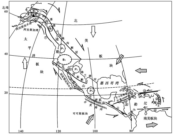
图 1 阿拉斯加—科迪勒拉—马德雷反S状旋扭造山带
①布鲁克斯断层; ②科育库卡断层; ③德纳里断层; ④卡斯特莱山断层; ⑤落基山地沟走滑断裂; ⑥海岸山走滑断裂; ⑦费尔威瑟弧形断层; ⑧圣安德烈斯走滑断裂; ⑨加利福尼亚湾斜列转换断层带; ⑩南马德雷山—巴拿马火山断裂线; ⑪委内瑞拉EW向断层; ⑫小安的列斯弧形断形断裂; ⑬海地岛(波多黎各)北岸EW向断层; ⑭古巴左旋走滑断层; ⑮开曼海沟断裂带; P1-哥伦比亚高原; P2-科罗拉多高原; P3-墨西哥高原; B1-科育库卡盆地; B2-鲍瑟尔盆地; B3-大盆地; B4-帕拉斯(马皮米)盆地半侧箭头示断裂、造山带、岛弧相对运动指向。空心箭头示北美板块与太平洋板块相对运动方向; 实心箭头示北美板块与南美板块相对扭动方向; 半空半实箭头示两者的合力。
Figure 1. Alaska-Cordilleran-Madre reversed S-shaped transrotational orogenic belt

图 2 北半球大陆西南边缘反S状造山带构造地貌模式
Ⅰ-Head arc; Ⅱ-Middle section; Ⅲ-Tail arc
Figure 2. 3D tectono-geomorphological model of the reversed S-shaped orogenic belt on the southwestern margin of the continent in the northern hemisphere

图 3 阿尔卑斯—喜马拉雅—印尼反S状旋扭构造连锁山链略图
Ⅰ.阿尔卑斯—狄那里克—克里特反S状旋扭造山带; Ⅱ.东托罗斯—扎格罗斯—莫克兰反S状旋扭造山带; Ⅲ.帕米尔—喜马拉雅反S状旋扭造山带; Ⅳ.青藏—滇缅—印尼批S状旋扭造山带; 黑线条示构造线; 单箭头示走滑断层; 斜方网示冈瓦纳裂解板块; 空心箭头示大陆反大洋板块相对运动方向
示螺旋上升; 示螺旋下降Figure 3. Alps-Himalaya-Indonesia reversed S-shaped transrotational mountain chain
-
[1] 李四光.旋卷构造及其他有关中国西北部大地构造体系复合问题[J].地质学报, 1954, 34(4). http://www.wanfangdata.com.cn/details/detail.do?_type=perio&id=QK000000377088 [2] 李四光.地球表面形象变迁之主因[J].中国地质学会志, 1926, 6(3~4):209~262. http://www.wanfangdata.com.cn/details/detail.do?_type=perio&id=QK199701067037 [3] Lee JS.Some characteristic structural types in eastern Asia and their bearing upon the problem of continental movements[J]. Geological Magazines, 1929, 66(8, 9, 10). [4] 李四光.地壳构造与地壳运动《天文、地质、古生物》资料摘要(初稿)[M].1972, 科学出版社. [5] 李东旭.旋扭构造动力学[M]:北京, 地质出版社, 2003, 188~205. [6] King Ph B.New Tectonic Map of North America, 1: 5000000.GSA Bulletin., 1969. [7] Ratchkovski NA.Wiemer S, Hansen RA.Seism tectonics of the Central Denali fault, Alaska and the 2002 Denali fault earthquake sequence[J].Bull.Seis.Soc.Am.6B, 2004 S156~S174. [8] Fisher MA, Harris RA, Nokleberg WJ, Pelerine L, Glen JM.Geophysical data reveal the crustal structure of the Alaska Range orogen within the aftershock zone of the M=7.9 Denali Fault earthquake.Bull.Seis.Soc.Am.B6, 2004, S107~S131. [9] Martirosyan A, Ansen RH, Ratchkovski N.Strong-motion records of the 2002 Denali Fault, Alaska earthquake[J].Earthquake Spectra, 2004, 20, 579~596. doi: 10.1193/1.1777237 [10] Hansen RA, Ratchkovski NA.Seismological aspects of the 2002 Denali Fault, Alaska earthquake[J].Earthquake Spectra, 2004, 20, 555~563. doi: 10.1193/1.1777236 [11] Lanphere MA, Reed BL.The M cKinley sequence of granitic rocks:a key element in the accretionary history of southern Alaska (USA)[J].Jour Geophy Res, 1985, 90, B13:11413~11430. doi: 10.1029/JB090iB13p11413 [12] Platker G., Nasser CW, Zimmerman RA et al.Cenozoic uplift history of the Mount McKinley area in the central Alaska Range based on fission-trace dating[J].US Geol Sur Bull, 1992, 2041:202~212. [13] Avelallemant HG. Arc-parallel displacement within the western Aleutian Island, Alaska: Preliminary GPS results[A]. In: Geological Society of America, Century of the Pacific Rim[C]. 1999, 31(6), A~35. [14] Haussler P, Mueller J F, Moran S, Power J, Saltus R.Tectonics, Mountain Building, Subduction, and Volcanism in South-Central Alaska[M].U.S.Geological Survey, 2003. [15] Wyld S J, Umhoefer P, Wright J E. Reconstructing Northern Cordilleran Terranes along Known Cretaceous and Cenozoic Strike-slip Faults: Implications for BAJA BC Hypothesis and Other Models. [16] Parsons T, McCarty J, Thompson GA. Very different crUstal response of extreme extension in the southern basin and range and Colorado plaleou transition Pacific Section. American Association of Petroleum Geologists Publication GB78. [17] Lisowski M, Savage JC, Prescott WH.The velocity field along the san Andreas Fault in central and southern California.J.Geophys[J].Res., 1996, 96(B5):585~611. [18] Nelson M R, Jones EH.Paleomagnetism and crustal rotations along a shear zone, Las Vegas Rangs, South Nevada[J].Tectonics, 1987, 6:13~33. doi: 10.1029/TC006i001p00013 [19] Martel SJ.Formation of compound strike-slip fault zones, Mount Abbot quadrangle, California[J].J.Struct.Geol., 1990, 12 (7):869~882. doi: 10.1016/0191-8141(90)90060-C [20] Schwartg DP.Paleoseismicify, persistence of segments and temporal clustering of large earthquakes—example from the San Andres, Wasatch, and lost River fault zone.USGS Open-file Report, 1989, (315):361~375. [21] Caire A.Geotectonique giratoire[J].Geologie en Mijnbouw, 1979.58(2):241~252. [22] Pindell J, Kennan L.Kinematic Evolution of the Gulf of Mexico and Caribbean.GCAGST, 2001. [23] Moran-Zenteno, Dante J.et al.Timing and petrogenesis of Tertiary silicic volcanism in relation to strike-slip tectonics in the northcontrail part of Sierra Madre Del Sur, Mexico.GSA, 2003. [24] Alniz-àlvarez SA, Nieto-Samaniego AF, Morá n-Zenteno DJ, Alba-Aldave L.Rhyolitic volcanism in extension zone associated with strike-slip tectonics in the Taxco region, southern Mexico[J].Journal of Volcanology and Geothermal Research, 118:1~14. doi: 10.1016/S0377-0273(02)00247-0 [25] Rivas JZ.Structural model of the Chiaps-Tabasco area (Southeast Mexico).CGG-ASI, 2003. [26] Pulliam J, et al. Aftershock study of the subduction to strike-slip transition of the North American-Caribbean Plate boundary in the Dominiean Republic. Earthquakes. IRIS. 5-year proposal. 2006. [27] Haenggi W T. Tectonic history of the Chihuahua trough, Mexico and adjacent USA. TOMO LIV, 2001, 28~66, Bolec de la Socieded Geologica, Mexicana. [28] 李东旭.地质力学与系统论[J].地球科学1989增刊. http://www.wanfangdata.com.cn/details/detail.do?_type=perio&id=QK000000259852 [29] Bajc J, et al.JHD and DD methods of relocation on the 1998 Bovae-KRN mountain (Slovenia) earthquake sequence and mechanics of moderate strike-slip events[J].Geophysical Research Abstracts, 2003, 5:07601. [30] Bertoluzza L, Perotti CR.A finite-element model of the stress field in strike-slip basins:implications for the Permian tectonics of the Southern Alps (Italy)[J].Tectonophysics, 1997, 208:185~197. doi: 10.1016-S0040-1951(97)00140-6/ [31] Fitgko F, Suhadolc P, Costa G.Realistic strong ground motion scenarios for seismic hazard assessment studies at the Alps-Dinarides Junction.University of Trieste.2003. [32] Meijninger BML.Geographic Information systems analysis of northwestern Greece:A tectonic investigation of northwestern Greece by means of remote sensing analysis and digital Cerrain analysis.Utrecht University, The Netherlands.2001. [33] Komac B. The Karst springs of the Kanin massif. Geografskizbornik, 2001, XLI. 2001. [34] Van Bemmelen RW.The Alpine loop of the Tethys zone.Tectonophysics, 1969, 8(2):107~113. doi: 10.1016/0040-1951(69)90084-5 [35] Vialon P, Rochette P, Menard G. Indentation and rotation in the western Alpine. In: Coward MP, Dietrich MP, Dietrich D, Park RG (eds. ), Alpine Tectonics. Special Publication Geological Society London, 1989, 45: 329~338. [36] Megerhoff Arther A et al. Surge Tectonics: A new hypothesis of Earth dynamics. In: S Chatterjee, N Hotton Ⅲ(eds), New Concepts in Global Tectonics. Texas: Texas Tech University Press. 1992, 367~371. [37] Papagachos BC, Comninakis PE. Models of Lithospheric interaction in the Aegean area. In: Biju-Duval B, Montadert L (eds), Structural History of the Mediterranean Basins. Paris: Edition Techniqe. 1977, 319~331. [38] Papagachos BC, et al.Fault plane solutions in the Aegean sea and the surrounding area and their tectonic implication.Bollettino di Geofisica Teorica ed Applicata—An International Journal of Earth Sciences, 1998, 39(3):199~218. [39] HessamiK, Koyi HA, Talbot CJ. The significance of strike-slip faulting in the basement of the Zagros fold and thrust belt (abstract). 2001, 24(1), Hans Ramberg Tectonic Laboratory, Institute of Earth S ciences, Uppsala University. [40] Inger S, Allen M, Blanc E, Hassami K, Talebian M, Jackson J. Regional-to reservoir-scale tectonic evolution of the Zagros Orogenic Belt (abstract), 2002, 24(1), Hans Ramberg Tectonic Laboratory, Institute of Earth Science, Uppsala University. [41] Hessami K. Tectonic History and present-day deformation in the Zagros fold-thrust belt. Comprehensive Summaries of Uppsala Dissertations from the Faculty of Science and Technology 700, Uppsala. 2002. [42] Farhoudi G, Karing DE.Makran of Iron and Pakistan as an active arc system.Geodogy, 1997, 5(11):664~668. [43] Wellman HW.Active wrench fault of Iran, Afghanistan and Pakistan.Geologisch Rundschan, 1966, 55(2):719~735. doi: 10.1007%2FBF02029650 [44] Lohr T.A Short Story about the Geological History of the Pamir —Review:Lothar Ratshbacher University of Mining and Technology, Freiberg, 2001. [45] 李海兵, Franck Valli, 许志琴, 杨经绥, Paul Tapponnier, Robin Lacassin, 陈松永, 戚学祥.Marie-Luce Chevalier.喀喇昆仑断裂的变形特征及构造演化[J].中国地质, 2006, 33(2):239~255. doi: 10.3969/j.issn.1000-3657.2006.02.002 [46] 许志琴, 等.青藏高原与大陆动力学—地体拼合、碰撞造山及高原隆升的深部驱动力[J].中国地质, 2006, 33 (2):221~238. http://d.old.wanfangdata.com.cn/Periodical/zgdizhi200602001 [47] 李东旭, 周济元.地质力学导论[M].北京地质出版社, 1986, 223~225. [48] Beaudouin T, Bellier O, Sebrier M.Present-day stress and deformation field within the Sulawesi Island area (Indonesia): geodynamic implications.Société Géologique de France.2003, 174(3):305~317. doi: 10.2113/174.3.305 [49] 李四光.地质力学概论[M].科学出版社, 1962. [50] Dardji N, Villemin T, Rampnoux JP.Paleostress and strike-slip movement:the Gimandiri fault zone, West Java, Indonesia.1994. [51] Sich K.The Sumatran fault system, Indonesia.GIS Laboratory, 2006. [52] 钟大赉, 丁林.青藏高原的隆起过程以及机制讨论[J].中国科学(D辑), 1996, 26(4):289~295. doi: 10.3321/j.issn:1006-9267.1996.04.001 [53] 潘裕生.青藏高原的形成与隆升[J].地学前缘, 1999, 6(3):1~9. doi: 10.3321/j.issn:1005-2321.1999.03.002 [54] 肖序常, 李连栋主编.青藏高原的构造演化与隆升机制[M].广州:广东科技出版社, 2000. [55] 吴珍汉, 叶培盛, 胡道功, 等.青藏高原腹地的地壳变形与构造地貌形成演化过程[M].北京:地质出版社, 2003. [56] 潘桂堂、徐强、王立金, 等.青藏高原多岛弧—盆系格局机制[J].矿物岩石, 2001, 21(3). http://d.old.wanfangdata.com.cn/Periodical/kwys200103029 [57] 潘桂堂, 王立金.青藏高原区域构造格局及其多岛弧盆系的空间配置[J].沉积与特提斯地质, 2001, 21(3):1 ~26. doi: 10.3969/j.issn.1009-3850.2001.03.001 -

 下载:
下载:


计量
- 文章访问数: 284
- HTML全文浏览量: 104
- PDF下载量: 9
- 被引次数: 0
