Dynamic variation characteristics of in-situ stress in the 1605 Qiongshan M 7½ earthquake area and its implications to the Dongzhaigang subsidence, northeastern Hainan Island, China
-
摘要:
文章利用1605年琼山7½级地震区不同区块布设的3个地应力监测台站应变观测数据,进行了地应力动态变化分析并对其记录的应力突变信息进行了提取,分析了2016年3月—2018年5月地应力变化与构造活动情况,并探讨了东寨港地貌演化趋势及其沉陷机理。结果显示:研究区总体受北西向挤压应力场作用,使得位于马袅−铺前断裂与铺前−清澜断裂上盘的演丰和大致坡地区以拉张应力场为主,位于断层下盘的锦山地区以挤压应力场为主;马袅−铺前断裂和铺前−清澜断裂在区域应力场作用下,不断进行非震活动来调整局部应力场,其中,马袅−铺前断裂在2016年3—7月、2017年10月和2018年4月有过多次活动,铺前−清澜断裂在2017年10月和2018年4月有过2次活动,马袅−铺前断裂较铺前−清澜断裂活动能量强;应力场变化趋势指示以铺前−清澜断裂(F13-1)为界,东部有逐步抬升趋势,西部的东寨港可能还会持续沉降;断层活动趋势指示以马袅−铺前断裂(F2-2)为界,东寨港北部演丰地区的沉降速率应该大于南部三江地区;此外,体应变监测数据也指示了位于海南岛南北地震带下部的岩浆活动痕迹。综合研究认为,东寨港沉陷主要受深部岩浆上涌导致的马袅−铺前断裂与铺前−清澜断裂的正断活动控制,并受到全新世海平面变化与软土沉积地层性质导致软土流滑、砂土液化以及海水侵蚀等多方面影响。文章创新性的将钻孔应变观测技术应用于探索海岸带地区典型震陷地貌演化规律与趋势研究,在地应力监测与构造地貌研究领域都有着重要的学术价值,同时,该成果对东寨港地区红树林保护、城镇规划建设等方面亦具有重要的应用价值。
Abstract:Based on the strain data of three in-situ stress monitoring stations in different sections of the 1605 Qiongshan 7½ earthquake area, we studied the dynamic variations of in-situ stress and extracted the sudden stress changes recorded by them. We analyzed the in-situ stress variations and tectonic activity between March 2016 and May 2018 to discuss the geomorphological evolution trends and subsidence mechanisms at the Dongzhai Port. The results show that the study area was generally subjected to the NW-compressive stress field, which makes the tensile stress field dominate in the Yanfeng and Dazhipo areas in the hanging wall of the Maniao-Puqian fault(MPF) and the Puqian-qinglan fault(PQF), while the Jinshan area in the footwall of the faults by compressive stress. The MPF fault and the PQF fault have been constantly engaged in non-seismic activities to adjust the local stress field under the regional stress field, among which the MPF Fault had several activities in March–July 2016, October 2017, and April 2018, and the PQF fault had two activities in October 2017. The energy of the MPF activities is more intensive than that of the PQF. The variation trend of the stress field indicates a gradual upward trend in the east bounded by the MPF fault (F13-1) and possible continued subsidence in Dongzhaigang in the west. The fault activity trend implies that the subsidence rate in Yanfeng, the northern part of Dongzhaigang, bounded by the MPF fault (F2-2), should be greater than that in the southern Sanjiang area. In addition, the volume strain monitoring data also reveals traces of magmatic activity in the lower part of the N–S seismic zone of Hainan Island. The comprehensive study concluded that the Dongzhaigang subsidence is mainly controlled by the positive fault activity of the MPF and PQF faults due to the upwelling of deep magma and influenced by the Holocene sea level change and the properties of soft soil depositional strata leading to soft soil flow slip, sand liquefaction, and seawater erosion. We innovatively apply the borehole strain observation technology to explore the evolution law and trend of typical earthquake subsidence landforms in coastal zones, which has essential academic value in the fields of in-situ stress monitoring and tectonic geomorphology research, and the results also have significant application value for mangrove protection and urban planning and construction in Dongzhaigang area.
-
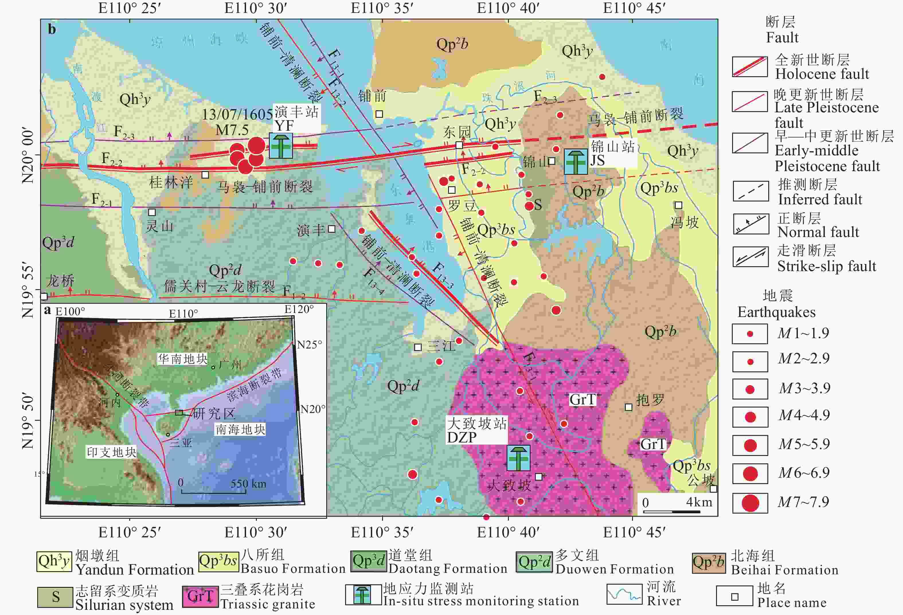
图 1 东寨港地区地质地貌与地应力台站分布图(底图据王超群等,2022修改)
a—南海西北部活动构造图;b—东寨港地区地质地貌与地应力台站分布图
Figure 1. Distribution of geological landforms and in-situ stress monitoring stations in the Dongzhaigang area(Base map modified from Wang et al., 2022)
(a) Active tectonic map of the northwestern South China Sea;(b) Distribution of the geological landforms and in-situ stress monitoring stations in the Dongzhaigang area
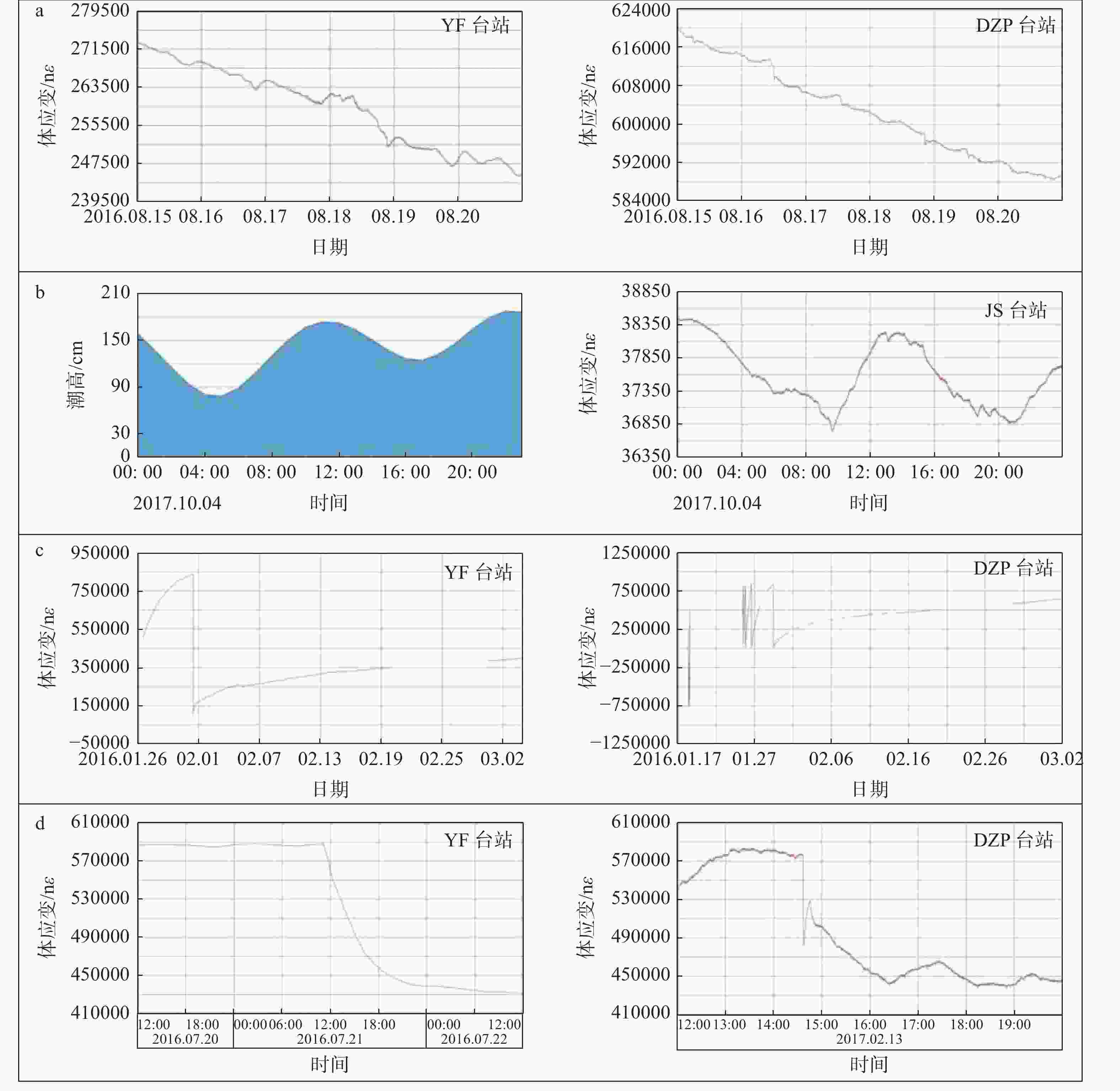
图 4 事件体应变特征曲线
a—台风应变曲线特征;b—潮汐应变曲线特征;c—仪器扰动应变曲线特征;d—构造活动应变曲线特征
Figure 4. Volume strain characteristic curves of different events
(a) Strain curve characteristics of typhoon ; (b) Strain curve characteristics of tidal; (c) Strain curve characteristics of instrumental disturbance; (d) Strain curve characteristics of tectonic activity
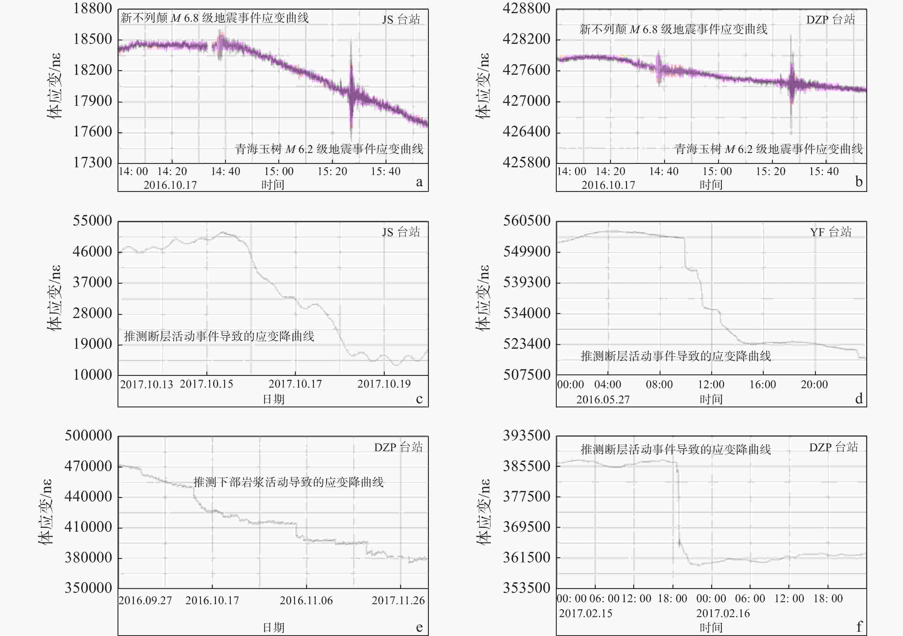
图 5 代表性构造事件应变曲线
a—JS台站监测到远程地震事件应变曲线;b—DZP台站监测到远程地震事件应变曲线;c—JS台站监测到的可能为断层活动事件应变曲线; d—YF台站监测到的可能为断层活动事件应变曲线;e—DZP台站监测到可能与岩浆活动事件相关的应变曲线;f—DZP台站监测到的可能为断层活动事件应变曲线
Figure 5. Strain curves of representative tectonic events
(a) Strain curves of representive romote seismic events detected by the JS station; (b) Strain curves of representative remote seismic events detected by the DZP station; (c)Strain curves may be related to fault activities detected by the JS station; (b) Strain curve may be related to fault activities detected by the YF station; (d)Strain curves may be related to magmatic events detected by the DZP station; (e)Strain curves may be related to fault activities detected by the DZP station
表 1 东寨港地区地应力监测数据参数表
Table 1. Parameter table of in-situ stress monitoring data in the Dongzhaigang area
台站名称 采集日期 数据量/GB 采集率/% 采集频率/Hz JS台站 2016.02−2018.06 5.51 96.6 10 DZP台站 2016.02−2018.05 4.82 87.0 10 YF台站 2016.02−2019.02 6.98 91.7 10 表 2 地应力监测数据特征与构造事件提取一览—表
Table 2. List of the features of in-situ stress monitoring data and extraction of tectonic events
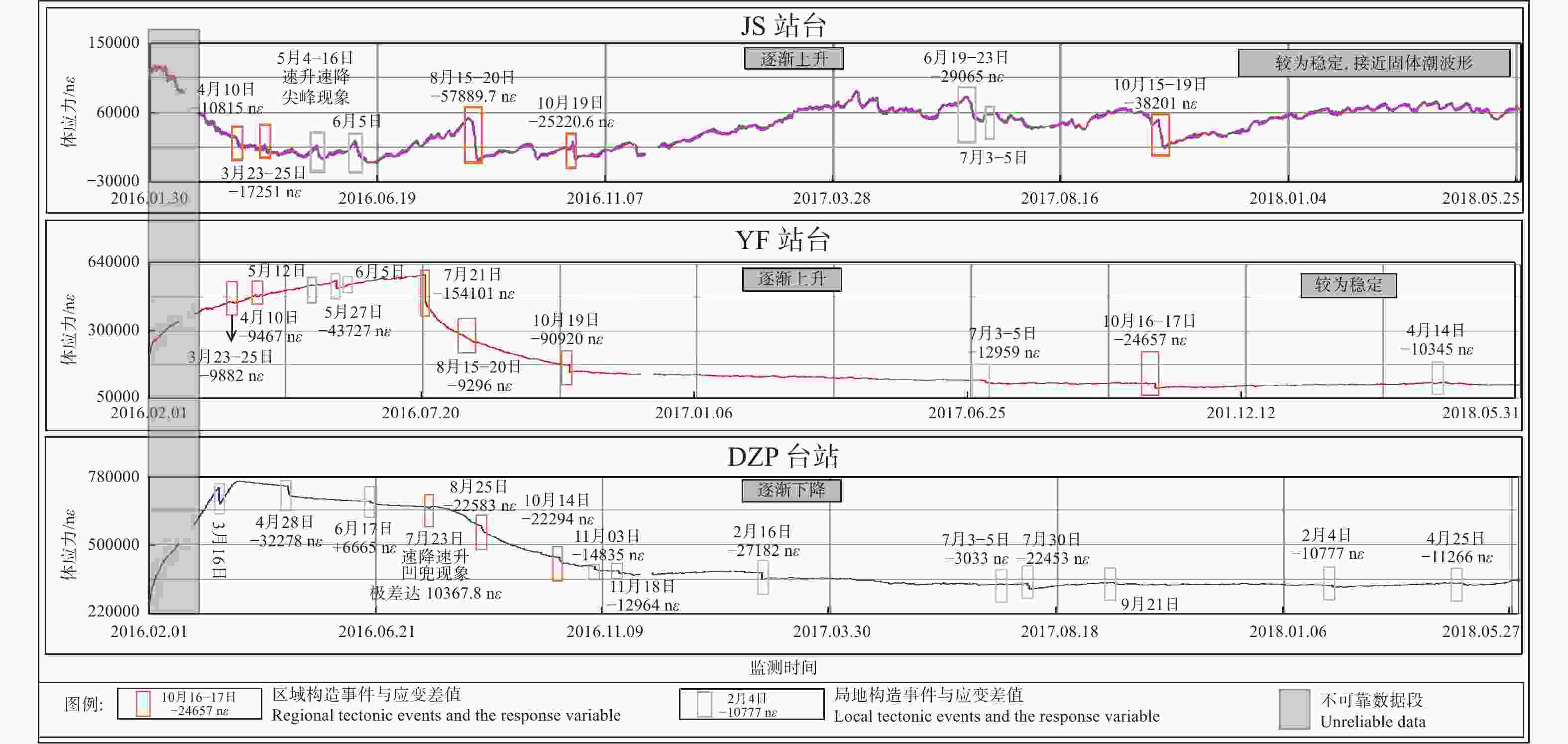
台站 应变值趋势特征 提取的主要应变突变数据特征 构造活动/事件分析 时间段 趋势特征 日期 应变突增差(nε) 应变突降差(nε) JS 2016.03—2016.06 波动中持续下降 2016.03.23—2016.03.25 17251.0 断层构造活动 2016.04.10—2016.04.11 / 13468.5 阿富汗7.1级大地震后能量释放/断层同震活动 2016.05.12—2016.05.13 / 19848.0 台湾宜兰县海域两次5.8与6.2级大地震 /断层同震活动 2016.07—2016.08 总体呈增加趋势;经历4次波动:
增长阶段速度慢,降低阶段速度快2016.08.14—2016.08.20 / 57889.7 断层活动 2016.09—2016.12 相对稳定;周期性波动 2016.09.20—2016.09.26 / 21375.6 断层活动 2016.10.18—2016.10.19 / 25220.6 地震远程效应/震后断层活动 2016.11.22—2016.11.28 / 20272.2 远程地震震后断层活动 2017.01—2017.12 波动中上升 2017.05.28—2017.06.19 30986.1 / 走滑断层蠕滑致能量积累 2017.10.15—2017.10.19 / 38201.4 断层活动 2018.01—2018.05 相对稳定;周期性波动 / / / / YF 2016.03—2016.07 逐渐上升 2016.03.23—2016.03.25 9882.0 阿富汗7.1级大地震后能量释放/断层同震活动 2016.04.10 9467.0 台湾宜兰县海域两次5.8与6.2级远程大地震 /震后断层活动 2016.05.27 / 43727.7 斐济群岛6.2级同震断层活动 2016.07—2016.12 逐渐下降 2016.07.21 / 154101.0 断层活动 2016.10.19 / 90920.0 地震远程效应 /震后断层活动 2017.01—2017.07 持续下降 2017.06.30—2016.07.08 / 18928.0 断层蠕滑活动 2017.08—2017.12 先降后升 2017.10.17 / 24713.9 断层活动 2018.01—2018.05 相对稳定 2018.04.14 / 10345.0 断层活动 2018.09—2018.12 逐渐上升 2018.09.26 / 19201.7 断层活动 DZP 2016.03—2016.07 缓慢下降 2016.03.16 / / 仪器干扰 2016.04.28 / 32278.0 断层活动 2016.07.23 10367(下降后迅速上升) 断层活动 2016.08—2016.12 快速下降 2016.08.25 / 22583.0 断层活动 2016.10.14 / 22294.0 地壳内部岩浆活动 2016.11.18 / 12964.0 米林6.9级远程地震震后断层活动 2017.01—2017.07 缓慢下降 2017.02.15 / 27182.0 地壳内部岩浆活动 2017.08—2017.12 相对稳定 2017.07.30—2017.07.31 / 22453.0 断层活动 2018.01—2018.02 缓慢下降 2018.02.04 / 10777.0 局地构造活动(推测) 2018.03—2018.05 缓慢上升—下降—较快速上升 2018.04.25—2018.05.03 / 11266.0 断层活动 -
[1] CHEN E M, HUANG Y Y, 1979. Preliminary Discussion on the 1605 Qiongzhou earthquake and its Seismogentic Structure. [J]. Seismology and Geology, , 04: 37-44. [2] CHEN E M, HUANG Y Y, 1989. Earthquake damage characteristics and three-dimensional photoelastic experiments of the 1605 Qiongzhou earthquake in Hainan Island[J]. Journal of Earthquake Engineering(2): 65-72. (in Chinese with English abstract) [3] CHEN H X, HONG H J, LIU H, 2009. Volcano-tectonic interaction and the relation with the state of volcanic activity[J]. Chinese Journal of Geophysics, 52(5): 1263-1269. (in Chinese with English abstract) [4] DING Y Y, ZHAO X T, HU D G, et al. , 2018. Late Cenozoic Fault activity in northeastern Hainan Island and its controlling effect on tectonic subsidence in Dongzhai port[J]. Acta Geoscientica Sinica, 39(2): 155-166. (in Chinese with English abstract) [5] HU D G, MA X M, JIA L Y, et al. , 2019. Report on investigation of active faults in Pan-Pearl River Delta region and evaluation of demineralization and crustal stability[R]. Institute of Geomechanics, Chinese Academy of Geological Sciences. (in Chinese) [6] HU D G, HAN J E, ZHANG L, et al. , 2022. Report on investigation and evaluation results of active faults and crustal stability in Hainan Island and offshore areas[R]. Institute of Geomechanics, Chinese Academy of Geological Sciences. (in Chinese) [7] HU J C, BAI D H, WANG W H, et al. , 2007. Magnetotelluric surveying and electrical structure of the deep underground part in Leiqiong volcanic area[J]. South China Journal of Seismology, 27(1): 1-7. (in Chinese with English abstract) [8] HUANG Z G, CAI F X, HAN Z Y, et al. , 1993. Leiqiong Quaternary volcano[M]. Beijing: Science Press. (in Chinese) [9] JIA L Y, HU D G, ZHANG L, et al. , 2021-12-17. The past and present lives of Hainan Dongzhai port[N]. China Mining News. (in Chinese) [10] JIANG J X, YIN G H, XU F Z, 2003. Relative stress field change of Ku'erle region before 8.1 earthquake in western Kunlun Pass[J]. Earthquake, 23(3): 89-96. (in Chinese with English abstract) [11] LI P, YANG M, LIU X, et al. , 1988. Analysis of active fault in the northern Qiongzhou( A. ). . Ding Yuanzhang. Collection of Earthquake Studies in Northern Hainan Island. Beijing: Seismological Press, 41~52 (in Chinese) . [12] LI F Q, 1985. In-situ stress measurement[J]. Chinese Journal of Rock Mechanics and Engineering, 4(1): 95-111. (in Chinese ) [13] LI W, JIA L Y, HU D G, et al. , 2019. Late Pleistocene tectonic history of the western segment of Maniao-Puqian fault: evidence from the Laocheng section, northern Hainan Island[J]. Geoscience, 33(5): 970-978. (in Chinese with English abstract) [14] LIANG D Y, XU G Q, XIAO Y, et al., 2021. Neogene-Quaternary stratigraphic standard and combined zoning of Haikou Jiangdong New District[J]. Science Technology and Engineering, 21(26): 11052-11063.(in Chinese with English abstract) [15] LIU H G, WU X J, LI F, et al. , 2018. Active characteristics of the middle segment of Maniao-Puqian fault in the Holocene[J]. Technology for Earthquake Disaster Prevention, 13(3): 588-599. (in Chinese with English abstract) [16] LIU Y, DU J S, HU Z W, et al. , 2021. Crustal magma plumbing system beneath the Quaternary volcanic area (northern Hainan Island, China) revealed by magnetotelluric data[J]. Journal of Volcanology and Geothermal Research, 419: 107362. doi: 10.1016/j.jvolgeores.2021.107362 [17] MENG Q, GAO K, CHEN Q, et al. , 2021. Seismogenic, coseismic and postseismic deformation and stress evolution of the 2008 Wenchuan earthquake: numerical simulation analysis[J]. Journal of Geomechanics, 27(4): 614-627. (in Chinese with English abstract) [18] PENG C G. 1983. Cause of the Land Subsidence Associated With the Historical Qiong Zhou Earth Quake (13 July 1605)[J]. Seismology and Geology, 5(3), 9-15. (in Chinese with English abstract) [19] PENG H, MA X M, JIANG J J, 2008. Analysis of the volume strain data from the Shandan in-situ stress monitoring station[J]. Journal of Geomechanics, 14(2): 97-108. (in Chinese with English abstract) [20] PENG H, MA X M, JIANG J J, 2011. In-situ stress measurement by differential strain analysis method in WFSD-1[J]. Journal of Geomechanics, 17(3): 249-261. (in Chinese with English abstract) [21] PENG H, MA X M, LI Z. etal. 2019. Report on Geostress Observation and Crustal Stability Evaluation in Bohai Strait, Taiwan Strait, Qiongzhou Strait and Other Sea Areas (Open Edition)[R]. Institute of Geomechanics, Chinese Academy of Geological Sciences. (in Chinese with English abstract) [22] PENG H, WU Z H, MA X M, 2006. Unmanned in-situ stress monitoring stations along the Qinghai-Tibet railway[J]. Journal of Geomechanics, 12(1): 96-104. (in Chinese with English abstract) [23] QIN X H, CHEN Q C, MENG W, et al. , 2018. Evaluating measured in-situ stress state changes associated with earthquakes and its implications: a case study in the Longmenshan fault zone[J]. Journal of Geomechanics, 24(3): 309-320. (in Chinese with English abstract) [24] QIU H, 2004. Research of distribution feature of strain field and evolution of surface rupture caused by earthquake fault[D]. Tianjin: Tianjin University. (in Chinese with English abstract) [25] QIU Z H, XIE F R, SU K Z, et al. , 2004. New era of borehole strain observation[J]. Recent Developments in World Seismology(1): 7-14. (in Chinese with English abstract) [26] QIU Z H, KAN B X, TANG L, et al. , 2006. Inversion of coseismic stress-triggered fault slips using borehole strain meter observations[J]. Acta Seismologica Sinica, 28(6): 596-602. (in Chinese with English abstract) [27] QIU Z H, 2010. A review of component borehole observation of stress-strain in China[J]. Journal of Geodesy and Geodynamics, 30(5): 42-47. (in Chinese with English abstract) [28] QIU Z H, TANG L, GUO Y P, et al. , 2020. Observing tectonic strain rates using four-gauge-borehole-strainmeters (FGBS)[J]. Progress in Geophysics, 35(5): 1688-1701. (in Chinese with English abstract) [29] TAN C X, ZHANG P, LU S L, et al. , 2019. Significance and role of in-situ crustal stress measuring and real-time monitoring in earthquake prediction research[J]. Journal of Geomechanics, 25(5): 866-876. (in Chinese with English abstract) [30] WANG C Q, JIA L Y, HU D G, et al. , 2021. Activity of eastern part of the Maniao-Puqian fault in northern Hainan Island and its evaluation of crustal stability[J]. Geology in China, 48(2): 618-631. (in Chinese with English abstract) [31] WANG C Q, JIA L Y, HU D G, et al. , 2021. Seismogenic structure of the 1605 Qiongzhou M1/2 earthquake and its Holocene activity history in northern Hainan Island, China: evidence from cross-section drilling and shallow seismic profile[J/OL]. Journal of Earth Sciences: https://kns.cnki.net/kcms/detail/42.1788.P.20211126.1558.004.html. [32] WANG C Q, JIA L Y, HU D G, et al. , 2022. Quaternary activity characteristics of the Maniao-Puqian fault in the Jiangdong New District of Haikou[J]. Acta Geologica Sinica, 96(2): 403-417. (in Chinese with English abstract) [33] WANG L M, CHEN C, LIU J P, et al. , 2023. On comprehensive application of seismic reflection and MASW method for investigation of urban subsurface active faults and underneath structures: a case study in Haikou City of Hainan Province, China[J]. Journal of Applied Geophysics, 212: 104982. doi: 10.1016/j.jappgeo.2023.104982 [34] WEST M, SÁNCHEZ J J, MCNUTT S R, 2005. Periodically triggered seismicity at Mount Wrangell, Alaska, after the Sumatra earthquake[J]. Science, 308(5725): 1144-1146. doi: 10.1126/science.1112462 [35] WU G H, 2008. Physical geography[M]. 4th ed. Beijing: Higher Education Press. (in Chinese) [36] XU Q H, 1985. Discussion on subsidence mechanism of Qiongshan earthquake[J]. South China Journal of Seismology, 5(4): 30-37. (in Chinese) [37] XU Q H, 1986a. Recent sinking in the Dongzhai Harbour area, northern Qiongzhou[J]. Marine Sciences, 10(1): 24-28. (in Chinese with English abstract) [38] XU Q H, 1986b. Understanding of seismic geology in Leiqiong Sag[J]. South China Journal of Seismology, 6(1): 83-93. (in Chinese) [39] XU Q H, 1986c. Formation and migration of Dongzhai port in the Northern Hainan Island and the major Qiongzhou earthquake of 1605[J]. Seismology and Geology, 8(3): 92-96. (in Chinese with English abstract) [40] XU Q H, 1988. New genesis of Dongzhai Harbor in Hainan Island[J]. Earth(4): 10-11. (in Chinese) [41] XU Q H, 1990. Subsidence caused by the Qiongzhou large earthquake in 1605 and the formation and vicissitude of Dongzhaigang Bay on Hainan Island[J]. Earthquake Research in China, 4(1): 71-82. [42] XU Q H, . 2006. The Coseismic Coast Fast Sinkage and the Following Possible Tsunami Caused by the 1605Qiongshan Strong Earthquake and the Evidence[J]. South China Journal of Seismology, 01: 17-27. (in Chinese with English abstract) [43] XU S C, GAO X K, LI H Y, 1982. Large-scale subsidence may be the evidence of phase transition in the source area: preliminary study on the genesis of the Qiongzhou earthquake[J]. South China Journal of Seismology, 2(1): 3-7. (in Chinese) [44] XIN P, WANG T, LIU J. , et al. , 2023. The geological structure and sliding model of slope in the triggering area of Yigong landslide in Tibet [J]. Journal of Geomechanics, 29(3): 1012-1023. (in Chinese with English abstract) [45] YAN Y D, CHEN E M, HUANG Y Y, 1988. Three—dimensional Photoelastic simulating experiments to tectonic stress field of great Qiongzhou earthquake Of 1605 in Hainan, China[J]. Northwestern Seismological Journal, 10(2): 63-70. (in Chinese with English abstract) [46] YANG J C, LI Y L, 2005. Principles of geomorphology[M]. Beijing: Peking University Press. (in Chinese) [47] ZHU H, 2008. Using borehole strain data to forecast the Yanjin M5.1 earthquake, Yunnan Province, on 22 July 2006[J]. Earthquake Research in Sichuan(1): 4-8. (in Chinese with English abstract) [48] 陈恩民, 黄咏茵. 1979. 1605年海南岛琼州大地震及其发震构造的初步探讨[J]. 地震地质, 04: 37-44. [49] 陈恩民, 黄咏茵, 1989. 1605 年海南岛琼州大地震的震害特征和发震构造研究. 地震学报, 11(3): 319 - 331. [50] 陈会仙, 洪汉净, 刘辉, 2009. 岩浆活动与构造应力的相互作用及其与火山活动状态的关系[J]. 地球物理学报, 52(5): 1263-1269. doi: 10.3969/j.issn.0001-5733.2009.05.015 [51] 丁莹莹, 赵希涛, 胡道功, 等, 2018. 琼东北晚新生代断裂活动及其对东寨港沉降的控制作用[J]. 地球学报, 39(2): 155-166. doi: 10.3975/cagsb.2017.112601 [52] 胡道功, 马秀敏, 贾丽云, 等, 2019. 泛珠三角地区活动断裂调查与去与地壳稳定性评价成果报告[R]. 中国地质科学院地质力学研究所. [53] 胡道功, 韩建恩, 张磊, 等, 2022. 海南岛及近海活动断裂与地壳稳定性调查评价成果报告[R]. 中国地质科学院地质力学研究所. [54] 胡久常, 白登海, 王薇华, 等, 2007. 雷琼火山区地下深部大地电磁探测与电性结构分析[J]. 华南地震, 27(1): 1-7. doi: 10.3969/j.issn.1001-8662.2007.01.001 [55] 黄镇国, 蔡福祥, 韩中元, 等, 1993. 雷琼第四纪火山[M]. 北京: 科学出版社. [56] 贾丽云, 胡道功, 张磊, 等, 2021-12-17. 海南岛东寨港的前世今生[N]. 第A3版, 地质调查, 中国矿业报. [57] 蒋靖祥, 尹光华, 许凤柱, 2003. 昆仑山口西8.1级地震前库尔勒测区相对应力场变化[J]. 地震, 23(3): 89-96. doi: 10.3969/j.issn.1000-3274.2003.03.012 [58] 李方全, 1985. 地应力测量[J]. 岩石力学与工程学报, 4(1): 95-111. [59] 李玶, 杨美娥, 刘行松等. 1988. 琼北地区活动性断裂的研究[A]. 丁原章主编. 海南岛北部地震研究文集. 北京: 地震出版社, 41 - 52. [60] 李薇, 贾丽云, 胡道功, 等, 2019. 琼北老城剖面记录的马袅-铺前断裂西段晚更新世活动历史[J]. 现代地质, 33(5): 970-978. [61] 梁定勇, 许国强, 肖瑶, 等. 2021. 海口江东新区新近纪-第四纪标准地层与组合分区[J]. 科学技术与工程,21(26): 11052-11063. [62] 刘华国, 吴小江, 李峰, 等, 2018. 马袅-铺前断裂中段全新世活动特征研究[J]. 震灾防御技术, 13(3): 588-599. [63] 孟秋, 高宽, 陈启志, 等, 2021. 2008年汶川大地震孕震、同震及震后变形和应力演化全过程的数值模拟[J]. 地质力学学报, 27(4): 614-627. [64] 彭华, 吴珍汉, 马秀敏, 2006. 青藏铁路无人值守地应力综合监测站[J]. 地质力学学报, 12(1): 96-104. [65] 彭华, 马秀敏, 姜景捷, 2008. 山丹地应力监测站体应变仪的地震效应[J]. 地质力学学报, 14(2): 97-108. [66] 彭华, 马秀敏, 姜景捷, 2011. 差应变法地应力测量: 以汶川地震断裂带科学钻探WFSD-1钻孔为例[J]. 地质力学学报, 17(3): 249-261. [67] 彭华, 马秀敏, 李振等. 2019. 渤海海峡、台湾海峡、琼州海峡等海域地应力观测与地壳稳定性评价成果报告(公开版)[R]. 中国地质科学院地质力学研究所. [68] 秦向辉, 陈群策, 孟文, 等, 2018. 大地震前后实测地应力状态变化及其意义: 以龙门山断裂带为例[J]. 地质力学学报, 24(3): 309-320. [69] 邱虎, 2004. 地震断层错动产生的应变场特征的研究及地表破裂的评价[D]. 天津: 天津大学. [70] 邱泽华, 谢富仁, 苏恺之, 等, 2004. 发展钻孔应变观测的战略构想[J]. 国际地震动态(1): 7-14. [71] 邱泽华, 阚宝祥, 唐磊, 等, 2006. 用钻孔应变资料反演同震应力触发断层活动[J]. 地震学报, 28(6): 596-602. [72] 邱泽华, 2010. 中国分量钻孔地应力-应变观测发展重要事件回顾[J]. 大地测量与地球动力学, 30(5): 42-47. [73] 邱泽华, 唐磊, 郭燕平, 等, 2020. 用四分量钻孔应变仪观测构造应变速率[J]. 地球物理学进展, 35(5): 1688-1701. [74] 谭成轩, 张鹏, 路士龙, 等, 2019. 原位地应力测量与实时监测在地震预报研究中的作用和意义[J]. 地质力学学报, 25(5): 866-876. [75] 王超群, 贾丽云, 胡道功, 等, 2021. 海南岛北部马袅-铺前断裂 东段活动性与地壳稳定性评价[J]. 中国地质, 48(2): 618-631. [76] 王超群, 贾丽云, 胡道功, 等, 2022. 海口市江东新区马袅-铺前断裂第四纪活动特征[J]. 地质学报, 96(2): 403-417. [77] 伍光和, 2008. 自然地理学[M]. 4版. 北京: 高等教育出版社. [78] 徐起浩, 1985. 琼山大震沉陷机理讨论[J]. 华南地震, 5(4): 30-37. doi: 10.13512/j.hndz.1985.04.004 [79] 徐起浩, 1986a. 琼北东寨港地区的近期下沉[J]. 海洋科学, 10(1): 24-28. [80] 徐起浩, 1986b. 对雷琼凹陷地震地质的认识[J]. 华南地震, 6(1): 83-93. [81] 徐起浩, 1986c. 海南岛北部东寨港的形成、变迁与1605年琼州大地震[J]. 地震地质, 8(3): 92-96. [82] 徐起浩, 1988. 海南岛东寨港成因新说[J]. 地球(4): 10-11. [83] 徐起浩. 2006. 1605年琼山强地震导致的同震海岸快速下沉、可能紧随的海啸及其证据[J]. 华南地震, 01: 17-27. [84] 许寿椿, 高喜奎, 李海玉, 1982. 大面积沉陷可能是震源区相变的证据: 琼州大震成因初探[J]. 华南地震, 2(1): 1-5. [85] 辛鹏, 王涛, 刘甲美, 等, 2023. 西藏易贡滑坡源区坡体赋存的地质结构及其滑动模式[J]. 地质力学学报, 29(3): 1012-1023. [86] 颜玉定, 陈恩民, 黄咏茵, 1988. 1605年琼州大地震构造应力场的三维光弹实验[J]. 西北地震学报, 10(2): 63-70. [87] 杨景春, 李有利, 2005. 地貌学原理[M]. 北京: 北京大学出版社. [88] 朱航, 2008. 使用钻孔应变测值预测2006年7月22日云南盐津5.1级地震[J]. 四川地震(1): 4-8. [89] 彭承光. 1983. 1605年7月13日琼州历史地震陆沉原因[J]. 地震地质, 5(3), 9-15. -


 下载:
下载:
