


Applications and prospects of geophysical exploration technologies in large-scale oil and gas engineering construction
-
摘要: 大型油气工程是国家能源安全的重要保障。长输管道、炼化工程与地下储库等各类油气工程项目协同配合,在国计民生中发挥着不可替代的作用。综合勘察贯穿于工程选址、设计、施工与运维的全过程,需要准确查明长输管道沿线的地质隐患、炼化厂区的地基条件、地下空间的岩体完整性和稳定性等。但传统钻探等技术存在复杂地形适应性差、探测范围有限、扰动场地、成本高、周期长等短板。工程物探技术因其无损、快速、可实现三维精细探测的特点,可以有效解决上述难题,成为勘探工作的重要环节。现阶段可控源音频大地电磁法(CSAMT)、高密度电法、浅层地震勘探、地质雷达及微动探测等工程物探方法已在油气工程建设中得到广泛应用,在管道沿线勘察、岩溶发育区地基探测、地下储库勘察等方面取得了良好效果。随着无人机技术发展,航空物探将有效解决复杂地形探测区域的人员安全与探测效率问题;人工智能可以有效提高物探数据处理与反演的效率与精度;通过空−地−井联合反演,可以使不同物探方法取长补短,实现三维高精度成像;分布式光纤声波传感技术(DAS)的发展则为地质体的实时动态监测提供了全新路径。工程物探技术在智能化、多维化、实时化等方面不断进步,将为大型油气工程建设提供更加坚实的技术支撑。Abstract:
Objective The construction of large-scale oil and gas engineering projects serves as a strategic cornerstone for ensuring national energy security. Various types of projects, including long-distance pipelines, refining and petrochemical facilities, and underground storage facilities, work together to support the national economy and people’s livelihoods. An integrated site investigation runs from site selection and design to construction and operation. Its core tasks include identifying geological hazards along pipelines, assessing foundation conditions at refining and chemical facilities, and evaluating rock mass integrity and stability in underground spaces. However, conventional investigation methods, including drilling, have limitations such as poor adaptability to complex terrain, limited exploration coverage, site disturbance, high costs, and long investigation periods. Methods Engineering geophysics with its unique advantages of being non-destructive, rapid, and capable of 3D exploration has become the solution to the aforementioned challenges. Methods such as controlled-source audio-frequency magnetotellurics (CSAMT), electrical resistivity tomography (ERT), shallow seismic exploration, ground penetrating radar (GPR), and microtremor surveys have been widely applied in oil and gas projects. Results Appropriate combinations of geophysical methods have demonstrated significant effectiveness in pipeline investigation, foundation exploration in karst-developed areas, and underground storage facility investigation. Conclusions With advances in unmanned aerial vehicle (UAV) technology, airborne geophysical surveys are expected to improve personnel safety and survey efficiency in areas with complex terrain. Artificial intelligence (AI)-driven geophysical data processing and inversion techniques are expected to achieve a computational acceleration of tens of thousands of times. Joint inversion of Airborne, ground-based, and borehole geophysical data can leverage the complementary strengths of different methods to achieve high-precision 3D imaging. The development of distributed acoustic sensing (DAS) technology provides a new approach to real-time dynamic monitoring of geological structures. Significance As engineering geophysics continues to advance in intelligence, multidimensional integration, and real-time monitoring, it will provide stronger technical support for large-scale oil and gas projects. -
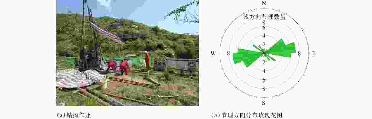
图 2 长输管道勘察作业图
Figure 2. Survey operations along a long-distance pipeline
(a) Drilling operation; (b) Rose diagram showing joint orientation distribution
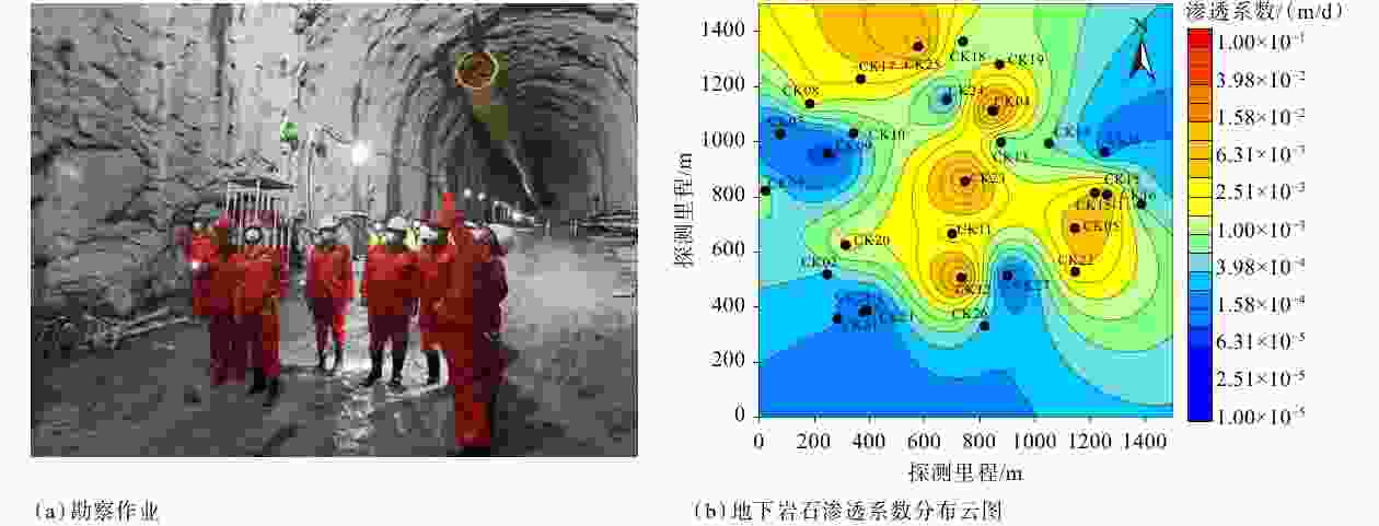
图 3 地下工程勘察
Figure 3. Underground engineering investigation
(a) Field survey; (b) Contour map of hydraulic conductivity distribution in subsurface rock masses
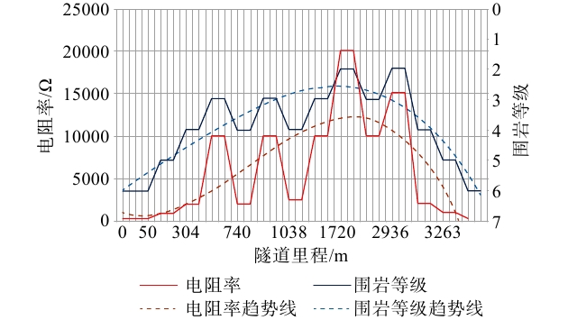
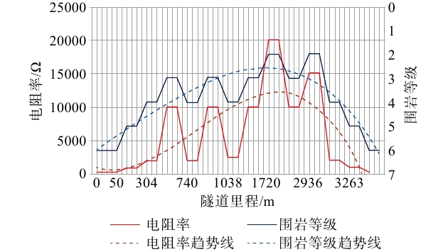
图 4 新气工程福建省某隧道电阻率与围岩等级关系图
Figure 4. Relationship between electrical resistivity and surrounding rock mass classification for a tunnel of the New Gas Project in Fujian Province
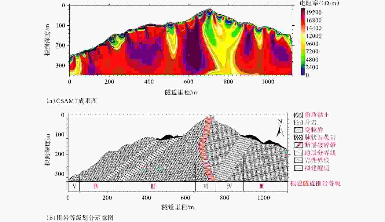
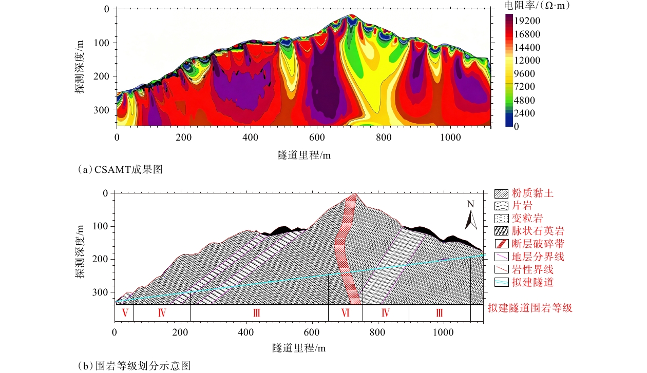
图 5 新气工程某隧道CSAMT探测结果
Figure 5. CSAMT survey results for a tunnel section in the New Gas Project
(a) CSAMT survey results; (b) Surrounding rock mass classification
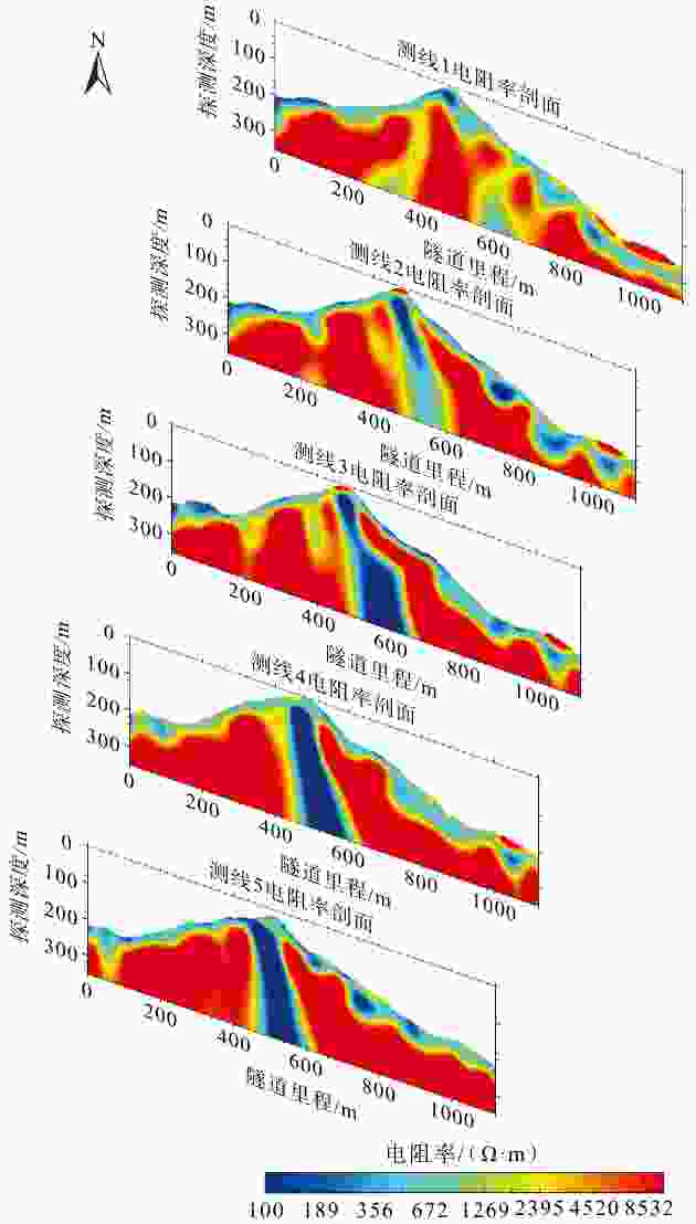
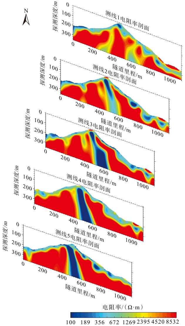
图 6 平行测线CSAMT成果切片图
图中各切片为平行测线的二维垂直剖面,子图按照数据采集方位排布;剖面水平轴为测线方向
Figure 6. Cross-section views of CSAMT survey results along parallel survey lines
Each panel is a 2D vertical section of parallel survey lines, ordered by data acquisition azimuth. The horizontal axis denotes the survey line direction.
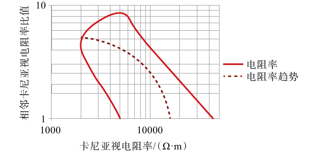
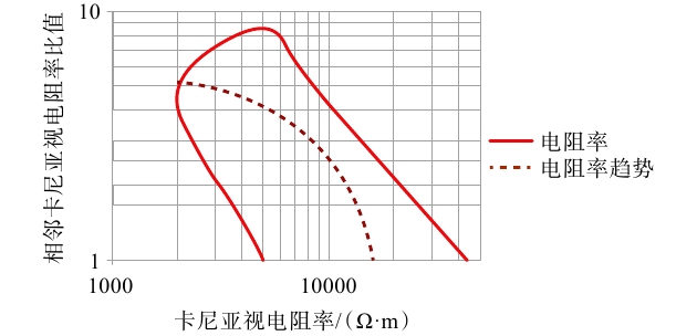
图 7 隧道轴线CSAMT判译破碎带曲线图
Figure 7. Fracture zone interpretation based on CSAMT data along the tunnel axis
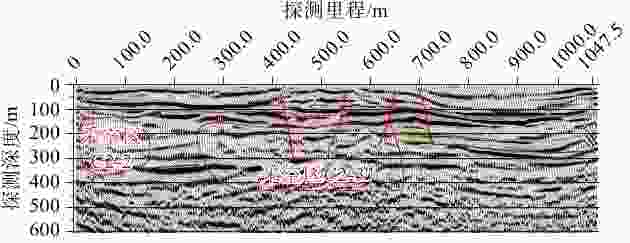
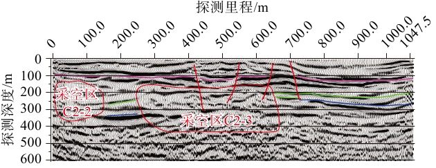
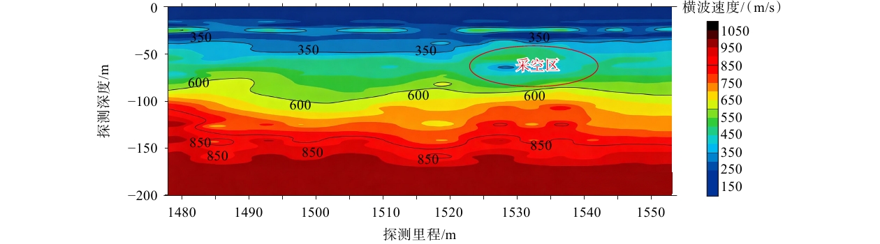
图 8 二维地震勘探探测结果与采空区判定
Figure 8. 2D seismic survey results and interpretation of goaf areas
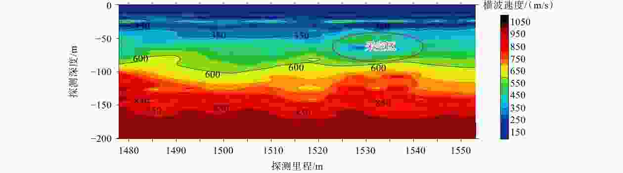
图 9 微动探测结果与采空区判定
Figure 9. Microtremor survey results and interpretation of goaf areas
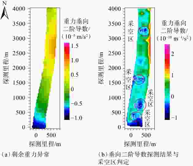
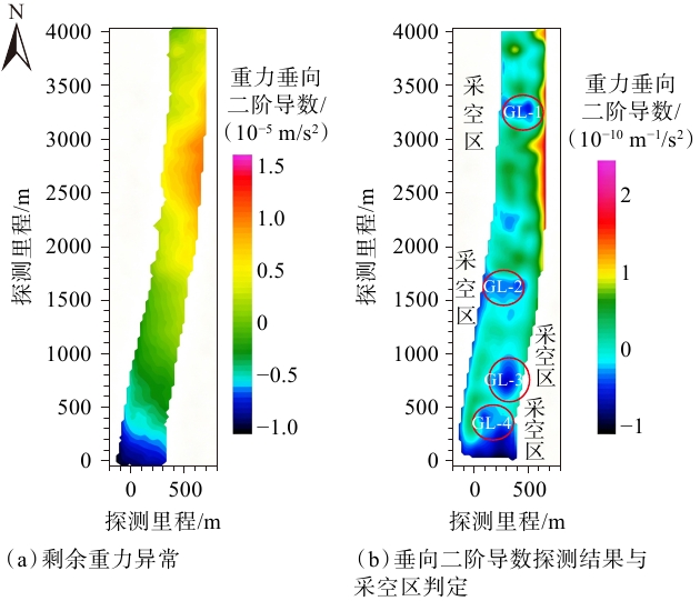
图 10 重力勘探结果
Figure 10. Gravity survey results
(a) Residual gravity anomaly; (b) Vertical second derivative and interpretation of goaf areas

图 11 高密度电法岩溶探测结果
Figure 11. Karst detection results obtained using the high-density electrical resistivity method
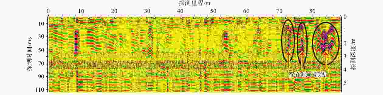
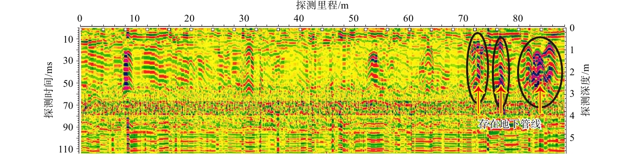
图 12 某炼化工程探地雷达探测结果
Figure 12. GPR survey results for a refining and petrochemical engineering project
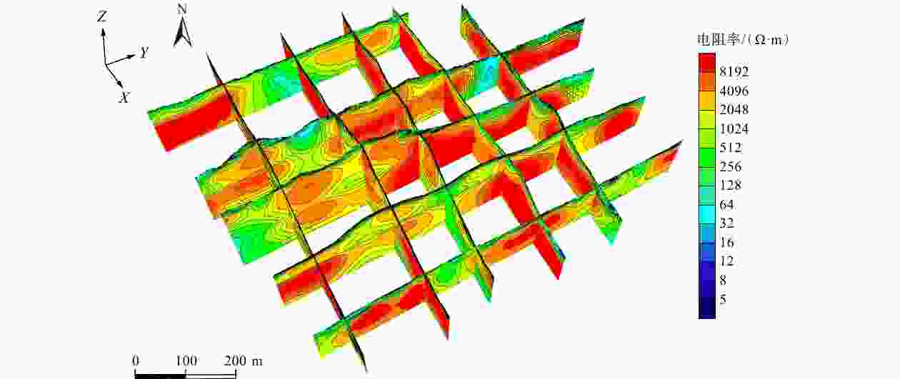
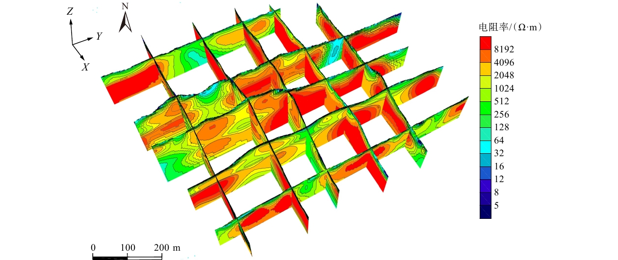
图 13 某地下工程可控源音频大地电磁法探测三维展示图
Figure 13. 3D visualization of CSAMT survey results for an underground engineering project
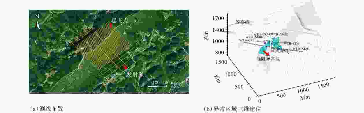
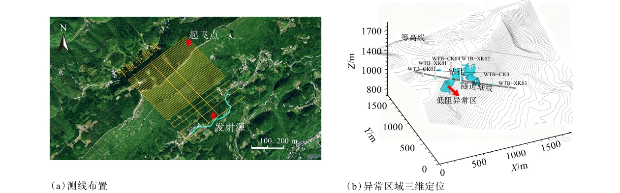
图 14 半航空瞬变电磁探测
Figure 14. Semi-airborne transient electromagnetic (SATEM) survey
(a) Survey line layout; (b) 3D positioning of anomalous areas
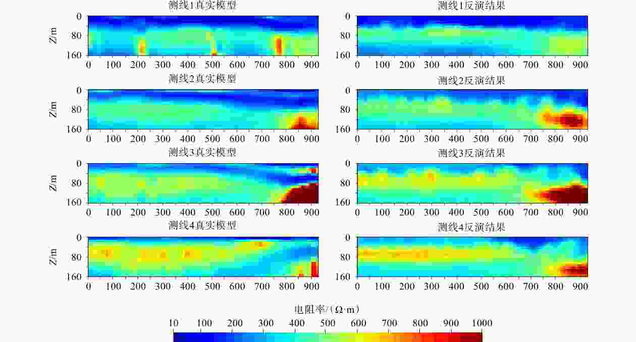
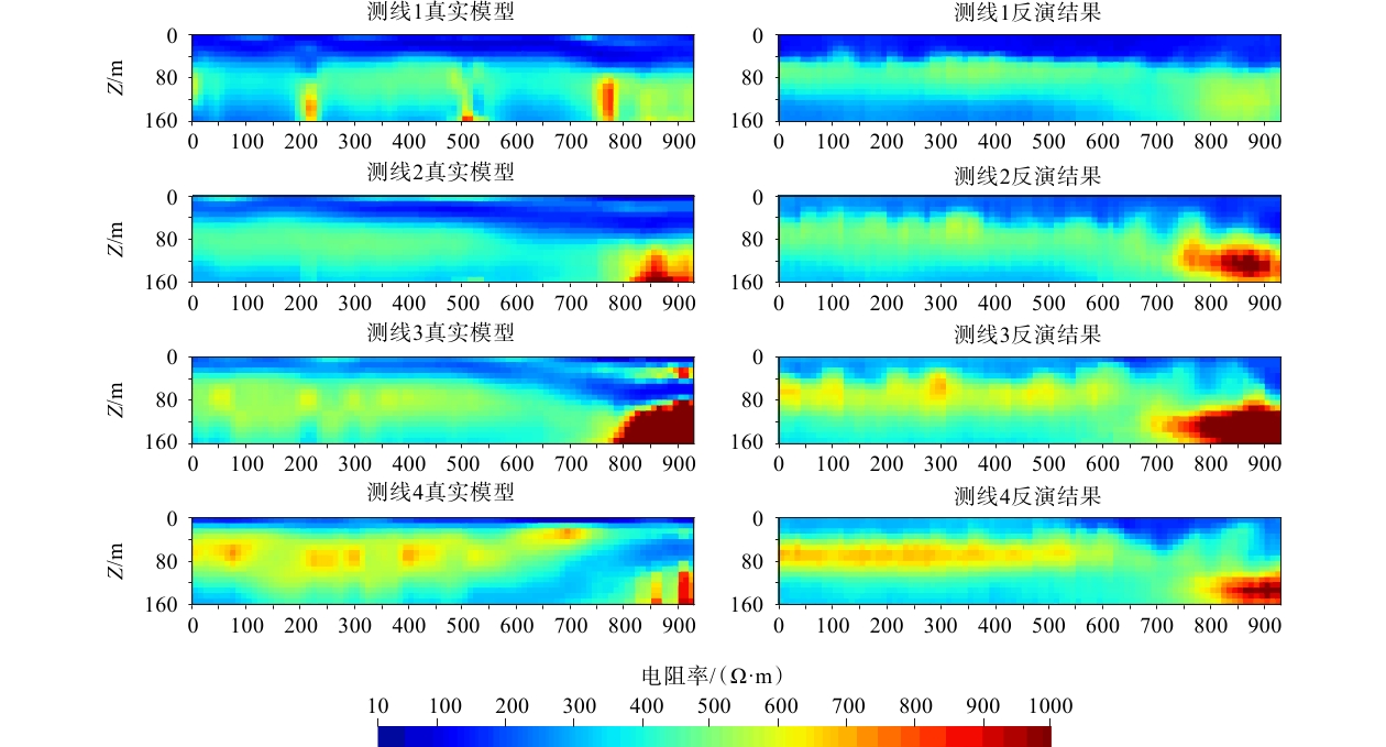
图 15 不同测线的反演结果与真实模型的对比分析(数据来源Zhang et al.,2025)
Figure 15. Comparison of inversion results for different survey lines with the true model (data from Zhang et al.,2025)
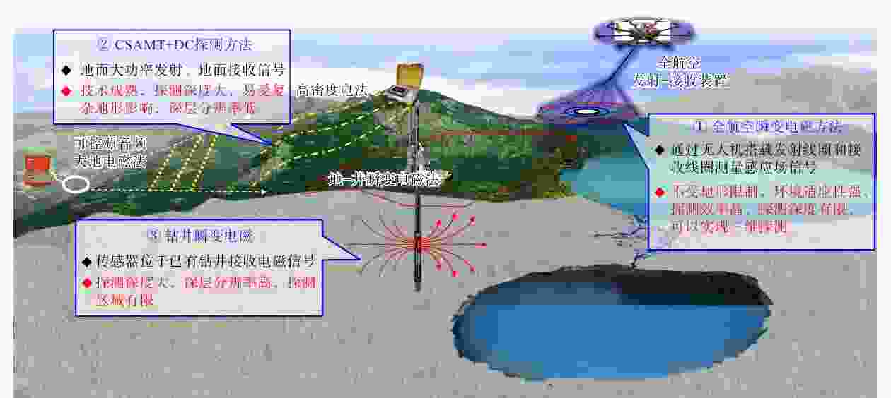
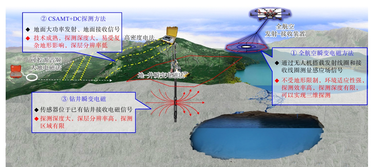
图 16 空−地−井联合探测体系方案示意图
Figure 16. Schematic diagram of an integrated air–ground–borehole exploration system
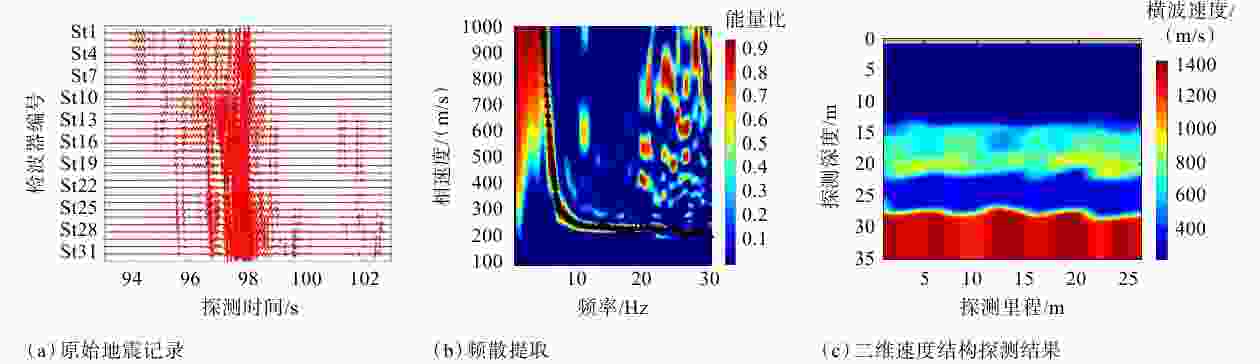
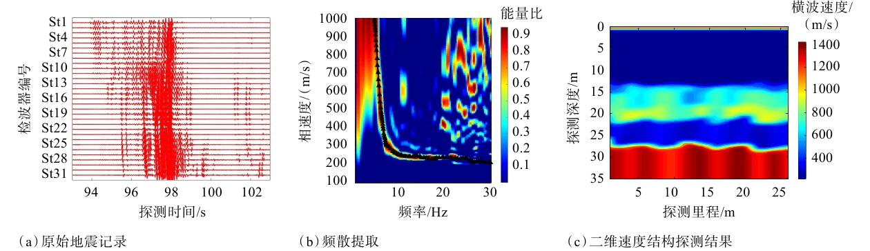
图 17 被动源监测探测成果(Wang et al., 2024)
Figure 17. Passive-source monitoring results (Wang et al., 2024)
(a) Raw seismic data, (b) Dispersion curve extraction, (c) Results of 2D velocity structure inversion
表 1 大型油气工程常用工程物探方法对比
Table 1. Comparison of common engineering geophysical methods applied in large-scale oil and gas engineering construction
方法类别 方法名称 适用条件 探测深度范围 分辨率(纵向) 地形适应性 抗干扰能力 优势 局限 应用场景 电法类 高密度电法 电阻率差
异明显区20.0~100.0 m 0.5~2.0 m 受地形起伏影响大 易受接地电阻、工业杂散电流干扰 探测效率高、成像直观 地形影响大、探测深度有限 岩溶普查、断层定位 电法类 可控源音频大地电磁法 深部构造
探测100.0~1000.0 m 纵向0~
100.0 m较好,可适
应一定地形起伏较好,人工源
可控,压制工
频干扰探测深度大、抗干扰强 横向分辨率
较低深埋隧道、断裂构造 电法类 跨孔电磁波CT 孔间精细
探测由钻孔深度控制 纵向0.5~
1.0 m不依赖地表地形(需钻孔) 中等,依赖孔
内耦合条件分辨率高、
可定量解释成本高、需要钻孔 溶洞探测 地震类 地震反射法 层状地层、基岩面探测 30.0~500.0 m
(浅层),深部可达2000 m以上受地震波
波长影响较差,需较平坦或可施工场地 中等,受振动
噪声影响大探测深度大 施工复杂、成本高 覆盖层厚度、基岩起伏 地震类 面波法 横波速度
结构探测一般5.0~50.0 m 纵向0.5~
3.0 m较差 较强,单点激
发抗环境振
动较好抗干扰强 探测深度与排列长度相关 隧道洞口覆盖层探测 地震类 跨孔弹性波CT 孔间速度
成像由钻孔深度控制 纵向0.3~
1.0 m不依赖地
表地形(需
钻孔)中等,受孔内换能器耦合
影响分辨率高、
信息丰富需要钻孔、成本高 岩体质量评价 电磁类 航空电磁法 大区域、复杂地形区 一般50.0~
500.0 m纵向0~
20.0 m极好,无地面通行限制 较差,易受到
周围环境电
磁干扰快速、无人
员风险浅层分辨率有限、成本高 管道选线区域性勘察 电磁类 地质雷达 浅层精细
探测一般0.5~50.0 m 较高,由天
线频率控制较好,需天线与地面耦合 弱,易受金属物体、无线电射频干扰 分辨率极高、无损 探测深度小(<50.0 m) 地下管线探测、浅部结构 声学类 声呐测腔 腔体形态
测量由井深及腔体尺寸控制 角度分辨率
约0.5°~1.0°,距离精度约0.1~0.3 m仅用于井孔/腔体内 较强,但需液体介质耦合 适用于腔体
成像方法需要腔体内介质耦合 盐穴储气库形态检测  下载: 导出CSV
-
[1] ALMPANIS A, MCLACHLAN P, GROMBACHER D, et al., 2025. Synthetic evaluation of two semi-airborne transient electromagnetic (TEM) systems utilizing inductive and galvanic sources in hydrogeological settings[J]. Geophysical Journal International, 244(2): ggaf467. doi: 10.1093/gji/ggaf467 [2] BENABID M K, BAUMGARTNER P, JIN G, et al., 2025. Leakage detection using distributed acoustic sensing in gas pipelines[J]. Sensors, 25(16): 4937. doi: 10.3390/s25164937 [3] BING Z, GREENHALGH S A, 2000. Cross-hole resistivity tomography using different electrode configurations[J]. Geophysical Prospecting, 48(5): 887-912. doi: 10.1046/j.1365-2478.2000.00220.x [4] CALDERÓN-MACÍAS C, SEN M K, STOFFA P L, 2000. Artificial neural networks for parameter estimation in geophysics[J]. Geophysical Prospecting, 48(1): 21-47. doi: 10.1046/j.1365-2478.2000.00171.x [5] CAO W P, HUANG X R, HU Y Z, et al. , 2022. Improving seismic interferometry for traffic noise by wavefield decomposition and deconvolution[C]//Second international meeting for applied geoscience & energy. Houston, Texas: Society of Exploration Geophysicists and the American Association of Petroleum Geologists: 2076-2080. [6] CHAI L W, TANG G Y, WANG G Q, et al., 2021. Application of ultra-high density cross-hole resistivity imaging in the detection of bored pile depth[J]. Chinese Journal of Engineering Geophysics, 18(2): 252-256. (in Chinese with English abstract) [7] CHEN L, GONG Z F, CHEN L, et al., 2026. Tunnel geological forward-prospecting based on an optimized beamforming seismic method[J]. Journal of Applied Geophysics, 247: 106135. doi: 10.1016/j.jappgeo.2026.106135 [8] CHENG K X, YANG Y F, LI S B, et al., 2025. Data-driven: challenges in pipeline risk assessment for oil and gas[J]. Pipeline Protection, 2(1): 88-96. (in Chinese with English abstract) [9] CHENG M, YANG D K, LUO Q, et al., 2025. Interpretation and application of three-dimensional fast forward and inversion for transient electromagnetic data[J]. Chinese Journal of Geophysics, 68(1): 342-354. (in Chinese with English abstract) [10] CHENG W S, SUN N Q, QI Z P, et al., 2024. The application of GATEM in tunnel geologic risk survey based on complex terrain[J]. Geophysics, 89(6): B453-B465. doi: 10.1190/geo2024-0047.1 [11] COLOMBO D, ROVETTA D, 2018. Coupling strategies in multiparameter geophysical joint inversion[J]. Geophysical Journal International, 215(2): 1171-1184. doi: 10.1093/gji/ggy341 [12] CUI Z X, YANG J H, ZHANG Y, et al., 2026. Injection and production mechanisms and operation strategies of CO2 serving as cushion gas of underground gas storage[J]. Natural Gas Industry, 46(2): 178-190. (in Chinese with English abstract) [13] CZARNY R, ZHU T Y, 2022. Estimating Rayleigh surface wave from ambient noise recorded by distributed acoustic sensing (DAS) dark fiber array in the city[C]//Second international meeting for applied geoscience & energy. Houston, Texas: Society of Exploration Geophysicists and the American Association of Petroleum Geologists: 2133-2137. [14] DADRASS JAVAN F, SAMADZADEGAN F, TOOSI A, et al., 2025. Unmanned aerial geophysical remote sensing: a systematic review[J]. Remote Sensing, 17(1): 110. doi: 10.3390/rs17010110 [15] DI Q Y, SHI K F, WANG M Y, et al., 2001. Water resources exploration with CSAMT and high density electric resistivity method[J]. Progress in Geophysics, 16(3): 53-57. (in Chinese with English abstract) [16] DI Q Y, WU F Q, WANG G J, et al., 2005. Geophysical exploration over long deep tunnel for west route of south-to-north water transfer project[J]. Chinese Journal of Rock Mechanics and Engineering, 24(20): 3631-3638. (in Chinese with English abstract) [17] DING G S, LI C, WANG J M, et al., 2015. The status quo and technical development direction of underground gas storages in China[J]. Natural Gas Industry, 35(11): 107-112. (in Chinese with English abstract) [18] DONG H B, WANG C L, 2003. Development and application of 2d resistivity imaging surveys[J]. Earth Science Frontiers, 10(1): 171-176. (in Chinese with English abstract) [19] DONG S W, LI T D, CHEN X H, et al., 2012. Progress of deep exploration in mainland China: a review[J]. Chinese Journal of Geophysics, 55(12): 3884-3901. (in Chinese with English abstract) [20] DU D D, SHI T, MA M, et al., 2025. Ground TEM survey for detecting old goaf water in Anshan Coal Mine[J]. China Mining Magazine, 34(S2): 427-431. (in Chinese with English abstract) [21] FU J H, DENG X Q, CHU M J, et al., 2013. Features of deepwater lithofacies, Yanchang formation in ordos basin and its petroleum significance[J]. Acta Sedimentologica Sinica, 31(5): 928-938. (in Chinese with English abstract) [22] FU T G, 2014. Study on technology of comprehensive geophysical method exploration of mine goaf and water accumulated area[J]. Coal Science and Technology, 42(8): 90-94. (in Chinese with English abstract) [23] GOES B J M, MEEKES J A C, 2004. An effective electrode configuration for the detection of DNAPLs with electrical resistivity tomography[J]. Journal of Environmental & Engineering Geophysics, 9(3): 127-141. doi: 10.4133/JEEG9.3.127 [24] GUAN Z N, HAO T Y, YAO C L, 2002. Prospect of gravity and magnetic exploration in the 21st century[J]. Progress in Geophysics, 17(2): 237-244. (in Chinese with English abstract) [25] GUO K, LI J J, ZHENG X B, 2015. Interlayer treatment process in cavity building for salt cavern gas storage-A case study of Jintan Gas Storage of West-to-East Gas Pipeline[J]. Oil & Gas Storage and Transportation, 34(2): 162-166. (in Chinese with English abstract) [26] HU L L, HE S, ZHANG L, et al., 2025. Based on the design structure matrix optimization of EPC project schedule for petroleum refining engineering[J]. Chemistry and Technology of Fuels and Oils, 61(5): 1204-1211. doi: 10.1007/s10553-025-01969-x [27] HUSSAIN Y, SCHLÖGEL R, INNOCENTI A, et al., 2022. Review on the geophysical and UAV-based methods applied to landslides[J]. Remote Sensing, 14(18): 4564. doi: 10.3390/rs14184564 [28] JIANG G Q, SHANG T X, HUANG J J, et al., 2022. Study on the development law of covered karst based on the comprehensive geophysical methods: taking Xuzhou area as an example[J]. Progress in Geophysics, 37(6): 2571-2579. (in Chinese with English abstract) [29] JIANG H, ZHAO X P, ZHAO Y G, 2024. Dual channel radar resistivity tomography and its application[J]. Progress in Geophysics, 39(3): 1285-1292. (in Chinese with English abstract) [30] JIANG W, HUANG L Q, ZHANG S H, et al., 2025. Advances in research on geological evaluation of compressed air energy storage in under-ground gas storage facilities[J]. Coal Geology & Exploration, 53(8): 62-75. (in Chinese with English abstract) [31] JING R Z, BAO G S, CHEN S Q, 2003. A review of the researches for geophysical combinative inversion[J]. Progress in Geophysics, 18(3): 535-540. (in Chinese with English abstract) [32] LAI W W L, DÉROBERT X, ANNAN P, 2018. A review of ground penetrating radar application in civil engineering: A 30-year journey from locating and testing to imaging and diagnosis[J]. NDT & E International, 96: 58-78. [33] LI L, 2013. The application on shallow seismic methods detection in unknown mine goaf[J]. China Mining Magazine, 22(3): 113-116. (in Chinese with English abstract) [34] LI P, LUO Y Q, TIAN Y, et al., 2021. Research progress of geophysical exploration technology for deep geological resources[J]. Progress in Geophysics, 36(5): 2011-2033. (in Chinese with English abstract) [35] LI S C, LIU Z Y, LIU B, et al., 2015. Boulder detection method for metro shield zones based on cross-hole resistivity tomography and its physical model tests[J]. Chinese Journal of Geotechnical Engineering, 37(3): 446-457. (in Chinese with English abstract) [36] LI X Y, ZHAO Q, HU S S, et al., 2026. Introducing complex geometries to Yee cells in FDTD for transient electromagnetic forward modeling[J]. Geophysics, 91(2): F1-F12. [37] LI Z R, CHU F, ZHOU Z Y, 2025. Progress and reflection on key equipment for oil and gas engineering of CNPC During the “14th Five-Year Plan” Period[J]. Petroleum Drilling Techniques, 53(6): 48-55. (in Chinese with English abstract) [38] LIAO Q, LIU C Y, DU J, et al., 2024. Application and prospect of artificial intelligence in empowering the operation and managment of oil and gas pipelines[J]. Oil & Gas Storage and Transportation, 43(6): 601-613. (in Chinese with English abstract) [39] LIN J, XUE G Q, LI X, 2021. Technological innovation of semi-airborne electromagnetic detection method[J]. Chinese Journal of Geophysics, 64(9): 2995-3004. (in Chinese with English abstract) [40] LIN R B, ZENG X F, SONG Z H, et al., 2020. Distributed acoustic sensing for imaging shallow structure Ⅱ: Ambient noise tomography[J]. Chinese Journal of Geophysics, 63(4): 1622-1629. (in Chinese with English abstract) [41] LIN Y, ZHONG H C, CHEN P, et al., 2026. Advances and trends in seismic interpretation techniques for large fan-delta conglomerate reservoirs: a case study of oil and gas exploration in Mahu Sag, Junggar Basin[J]. Oil Geophysical Prospecting, 61(1): 222-238. (in Chinese with English abstract) [42] LIU G F, MENG X H, TAN H D, et al., 2020. Case study: Joint seismic reflection and CSAMT data interpretation for mineral explorations in Fujian, China[J]. Acta Geophysica, 68(5): 1373-1385. [43] LIU J X, SUN H L, CHEN B, et al., 2016. Review of the gravity and magnetic methods in the exploration of metal deposits[J]. Progress in Geophysics, 31(2): 713-722. (in Chinese with English abstract) [44] LIU J X, ZHAO R, GUO Z W, 2019. Research progress of electromagnetic methods in the exploration of metal deposits[J]. Progress in Geophysics, 34(1): 151-160. (in Chinese with English abstract) [45] LIU L, ZHANG S B, QU Z C, 2025. Discussion on the pricing strategy for long-distance oil and gas pipeline projects in the Qinghai-Xizang Plateau region[J]. Oil & Gas Storage and Transportation, 44(12): 1430-1439. (in Chinese with English abstract) [46] LIU M H, CAL H Z, YANG H, et al., 2022. Three-dimensional joint inversion of ground and semi-airborne transient electromagnetic method[J]. Chinese Journal of Geophysics, 65(10): 3997-4011. (in Chinese with English abstract) [47] LIU S, HU X Y, GUO N, et al., 2023. Overview on UAV aeromagnetic survey technology[J]. Geomatics and Information Science of Wuhan University, 48(6): 823-840. (in Chinese with English abstract) [48] LIU S D, WU R X, ZHANG P S, et al. , 2001. High density electric resistance method applied to monitor and measure overburden failure above seam[J]. Coal Science and Technology, 29(4): 18-19, 22. (in Chinese with English abstract) [49] LIU W, LI Y P, HUO Y S, et al., 2013. Analysis of deformation and fracture characteristics of wall rock interface of underground storage caverns in salt rock formation[J]. Rock and Soil Mechanics, 34(6): 1621-1628. (in Chinese with English abstract) [50] LIU X D, ZHANG H S, HUANG X C, et al., 2002. The application of high density electrical method to karst geological survey in Yichun City[J]. The Chinese Journal of Geological Hazard and Control, 13(1): 72-75. (in Chinese with English abstract) [51] LIU Z Y, LI S C, LIU B, et al., 2015. Boulder detection method based on 3D resistivity cross-hole tomography in metro shield zones and its physical model experimental study[J]. Chinese Journal of Rock Mechanics and Engineering, 34(12): 2519-2530. (in Chinese with English abstract) [52] LUO Q B, YANG Y X, WU X M, et al., 2022. Application of comprehensive radioactive prospecting method on uranium prospecting in Lujing based on Kriging interpolation[J]. Journal of East China University of Technology (Natural Science), 45(2): 154-161. (in Chinese with English abstract) [53] LUO X, XU Z H, LI Z S, et al., 2020. Application of multi-parameter comprehensive geophysical prospecting method in exploration of goaf in coal mines[J]. Coal Engineering, 52(2): 32-37. (in Chinese with English abstract) [54] LU LV Q T, ZHANG X P, TANG J T, et al., 2019. Review on advancement in technology and equipment of geophysical exploration for metallic deposits in China[J]. Chinese Journal of Geophysics, 62(10): 3629-3664. (in Chinese with English abstract) [55] MA H X, LIU L H, YAN S C, et al., 2024. Unmanned aerial vehicle time domain electromagnetic detection combination pulse launch technology[J]. Journal of Central South University (Science and Technology), 55(10): 3756-3767. (in Chinese with English abstract) [56] MA Y S, CAI X Y, ZHAO P R, 2016. The support of petroleum engineering technologies in trends in oil and gas exploration and development-case study on oil and gas exploration in Sinopec[J]. Petroleum Drilling Techniques, 44(2): 1-9. (in Chinese with English abstract) [57] MARTIN E, LINDSEY N, DOU S, et al. , 2016. Interferometry of a roadside DAS array in Fairbanks, AK[C]//SEG technical program expanded abstracts 2016. Dallas, Texas: Society of Exploration Geophysicists: 2725-2729. [58] MI B B, XIA J H, TIAN G, et al., 2022. Near-surface imaging from traffic-induced surface waves with dense linear arrays: An application in the urban area of Hangzhou, China[J]. Geophysics, 87(2): B145-B158. [59] MIOCIC J M, HEINEMANN N, EDLMANN K, et al., 2022. Underground hydrogen storage: a review[J]. Geological Society, London, Special Publications, 528(1): 73-86. [60] MÖRBE W, YOGESHWAR P, HOFFMANN E, et al., 2026. Investigation of a graphite deposit with drone-based semi-airborne electromagnetics[J]. Geophysics, 91(3): B53-B61. [61] PATANWAR Y K, KIM H M, DEB D, et al., 2024. Underground storage of hydrogen in lined rock caverns: An overview of key components and hydrogen embrittlement challenges[J]. International Journal of Hydrogen Energy, 50: 116-133. [62] PENG B, QIANG S Y, SHI X Q, 2025. Optimizing 4D hydrogeological process monitoring using cross-hole electrical resistivity tomography (CHERT) via Bayesian experimental design[J]. Bulletin of Geological Science and Technology, 44(5): 293-301. (in Chinese with English abstract) [63] PENG G M, LIU Z, 2020. An overview of joint electromagnetic-seismic inversion and its future development[J]. Oil Geophysical Prospecting, 55(2): 465-474. (in Chinese with English abstract) [64] PRIOLO E, ZINNO I, GUIDARELLI M, et al., 2024. The birth of an underground gas storage in a depleted gas reservoir—Results from integrated seismic and ground deformation monitoring[J]. Earth and Space Science, 11(11): e2023EA003275. [65] QI D S, BA J H, LIU C, et al., 2017. A dynamic monitoring and analysis method for the solution mining process of salt-cavern gas storage[J]. Oil & Gas Storage and Transportation, 36(9): 1078-1082. (in Chinese with English abstract) [66] QI Y F, ZHI Q Q, LI X, et al., 2021. Three-dimensional ground TEM inversion over a topographic earth considering ramp time[J]. Chinese Journal of Geophysics, 64(7): 2566-2577. (in Chinese with English abstract) [67] QIAN X J, YOU S H, WANG R Z, et al., 2025. Underground hydrogen storage in salt cavern: a review of advantages, challenges, and prospects[J]. Sustainability, 17(13): 5900. [68] QIN J W, JIANG X T, XIE G C, et al., 2023. Karst exploration in urban complex environments based on electrical resistivity tomography: a case study of Beihuan New Village in Guigang City[J]. Geophysical and Geochemical Exploration, 47(2): 530-539. (in Chinese with English abstract) [69] RAFI M, MOHD NOH K A, ABDUL LATIFF A H, et al., 2024. Application of distributed acoustic sensing in geophysics exploration: comparative review of single-mode and multi-mode fiber optic cables[J]. Applied Sciences, 14(13): 5560. [70] RAICHE A, 1991. A pattern recognition approach to geophysical inversion using neural nets[J]. Geophysical Journal International, 105(3): 629-648. [71] RAMESH KUMAR K, HONORIO H, CHANDRA D, et al., 2023. Comprehensive review of geomechanics of underground hydrogen storage in depleted reservoirs and salt caverns[J]. Journal of Energy Storage, 73: 108912. [72] SAFAAN M H, METAWIE M, MARZOUK M, 2025. Subsurface utility detection and augmented reality visualization using GPR and deep learning[J]. Automation in Construction, 176: 106299 [73] SCHELL C A, LEVER E, GROTH K M, 2023. Strain-based design and assessment for pipeline integrity management: a review of applications and gaps[J]. International Journal of Pressure Vessels and Piping, 204: 104973. [74] SCHUSTER G T, CHEN Y Q, FENG S H, 2024. Review of physics-informed machine-learning inversion of geophysical data[J]. Geophysics, 89(6): T337-T356. [75] SHANG Y J, HE Y J, HUANG Z L, 2013. The application of cross-hole super-high density resistivity method CT to karst carve exploration[J]. Chinese Journal of Engineering Geophysics, 10(4): 545-550. (in Chinese with English abstract) [76] SHI J J, WU X, WANG Y B, 2025. Study on the detection capability of semi-airborne transient electromagnetic three-component technology for tabular anomalies[J]. Journal of Geophysics and Engineering, 22(5): 1276-1289. [77] SHI L L, REN J J, XING H W, et al., 2025. Application of CSAMT in geothermal resource exploration in western Horqin[J]. Oil Geophysical Prospecting, 60(S1): 83-86. (in Chinese with English abstract) [78] SHI Z J, YAO K, YAO N P, et al., 2020. 40 years of development and prospect on underground coal mine tunnel drilling technology and equipment in China[J]. Coal Science and Technology, 48(4): 1-34. (in Chinese with English abstract) [79] SONG C C, DENG Z H, NIU C F, 2019. Advances in production of chemicals such as light oilfins from heavy oil[J]. Chemical Industry and Engineering Progress, 38(S1): 86-94. (in Chinese with English abstract) [80] SONG H B, JIANG Z H, GUO Q, et al., 2026. Research progress and prospects of joint electromagnetic and seismic inversion methods[J]. Progress in Geophysics, 41(1): 156-173. (in Chinese with English abstract) [81] SU B Y, LIU S D, DENG L, et al., 2022. Monitoring direct current resistivity during coal mining process for underground water detection: an experimental case study[J]. IEEE Transactions on Geoscience and Remote Sensing, 60: 5915308. [82] SUN D S, LI A W, YANG Y H, et al., 2025. Research progress and prospects of deep stress measurement technology[J]. Journal of Geomechanics, 31(6): 1111-1126. (in Chinese with English abstract) [83] SUN H F, ZHANG Y Y, ZHAO Y C, et al., 2022. Present study situation review of borehole transient electromagnetic method[J]. Coal Geology & Exploration, 50(7): 85-97. (in Chinese with English abstract) [84] SUN H F, ZHANG N Y, LI D R, et al., 2023. The first semi-airborne transient electromagnetic survey for tunnel investigation in very complex terrain areas[J]. Tunnelling and Underground Space Technology, 132: 104893. [85] TAN Y F, 2012. Applicable research on comprehensive survey technology of engineering geology for large deeply - buried tunnel[J]. Journal of Railway Engineering Society, 29(4): 24-31. (in Chinese with English abstract) [86] TARKOWSKI R, 2019. Underground hydrogen storage: Characteristics and prospects[J]. Renewable and Sustainable Energy Reviews, 105: 86-94. [87] TIAN W F, HAO J J, YAN J Y, et al., 2010. Application of synthetic geophysical methods to deep exploration of Hanxing-type iron deposit[J]. Progress in Geophysics, 25(4): 1442-1452. (in Chinese with English abstract) [88] WANG C H, LI W, 2025. Major advances and prospects in in-situ stress measurement and estimation methods over the past 10 years (2014-2025)[J]. Journal of Geomechanics, 31(6): 1188-1209. (in Chinese with English abstract) [89] WANG D L, ZHOU Z M, LIN M L, et al., 2021. Status and thinking of development constraints of refining to chemical transformation in China[J]. Chemical Industry and Engineering Progress, 40(10): 5854-5860. (in Chinese with English abstract) [90] WANG H G, HUANG H C, BI W X, et al., 2021. Deep and ultra-deep oil/gas well drilling technologies: progress and prospect[J]. Natural Gas Industry, 41(8): 163-177. (in Chinese with English abstract) [91] WANG H, JI H G, 2010. Study on CT prospecting technology by the pole-pole cross-hole direct-current resistivity method[J]. Progress in Geophysics, 25(5): 1833-1840. (in Chinese with English abstract) [92] WANG J, Sun C, Lin T, et al., 2024. Influence of strong directional sources in ambient seismic imaging using traffic-induced noise[J]. Geophysics, 89(4): 15. [93] WANG L, LIU W, XI Z Z, et al., 2024. Deep learning audio-magnetotelluric and transient electromagnetic joint inversion[J]. Chinese Journal of Geophysics, 67(11): 4372-4384. (in Chinese with English abstract) [94] WANG X Q, WANG B Q, WANG B, et al., 2018. The current situation and development trend of China’s long distance natural gas pipeline[J]. Petroleum Planning & Engineering, 29(5): 1-6. (in Chinese with English abstract) [95] WANG X Z, WU J Q, WANG B, et al., 2025. New advances and future development directions in oil and gas engineering technologies of Yanchang Petroleum during “14th Five-Year Plan” period[J]. Petroleum Drilling Techniques, 53(6): 37-47. (in Chinese with English abstract) [96] WANG Y H, LI Y Q, JIAO Y, et al., 2026. Spatiotemporal seismic performance-informed evolution of corroded long-distance natural gas pipelines[J]. Reliability Engineering & System Safety, 272: 112563. [97] WANG Z, CAI X, YAN J, et al., 2018. Using the integrated geophysical methods detecting active faults: A case study in Beijing, China[J]. Journal of Applied Geophysics, 156: 82-91. [98] WEI L N, LI Y J, YIN C C, et al., 2025. Status and prospects of joint inversion of geophysical electromagnetic data[J]. Reviews of Geophysics and Planetary Physics, 56(6): 620-640. (in Chinese with English abstract) [99] WEN L, YANG Y, LUO B, et al., 2025. Oil and gas exploration in the Sichuan Basin since the 13th Five-Year Plan: significant advances and implications[J]. Natural Gas Industry, 45(12): 66-83. (in Chinese with English abstract) [100] WU Q, 2018. Digital transformation of oil & chemicals under the contemporary situation: from digital to intelligent[J]. Chemical Industry and Engineering Progress, 37(6): 2140-2146. (in Chinese with English abstract) [101] WU S H, Huang Q H, ZHAO L, 2024. Physics-guided deep learning-based inversion for airborne electromagnetic data[J]. Geophysical Journal International, 238(3): 1774-1789. [102] XIA S B, LIAO G Z, DENG G S, et al., 2024. Application of high-density electrical resistivity tomography and audio magnetotellurics for groundwater exploration in the karst area in southwestern China[J]. Geophysical and Geochemical Exploration, 48(3): 651-659. (in Chinese with English abstract) [103] XIAO L Y, ZHANG J Y, NIE Z P, et al., 2022. Underground energy storage engineering[J]. Advanced Technology of Electrical Engineering and Energy, 41(2): 1-9. (in Chinese with English abstract) [104] XIE B, ZHANG Y Y, WU X Y, et al., 2025. Research on the response of different flight modes under concave and convex terrain by semi-airborne transient electromagnetic method (SATEM)[J]. Journal of Applied Geophysics, 233: 105576. [105] XIE D K, LI W D, FU Y G, et al., 2025. Application of the combined detection of geophysical prospecting and shallow drilling geochemical prospecting in the concealed magmatic copper-nickel deposits in the shallow-covered area of the Dahuangshan in the Eastern Tianshan Metallogenic Belt[J]. Xinjiang Geology, 43(2): 369-377. (in Chinese with English abstract) [106] XIN J, WANG L Y, 2021. Impacts of “Dual Carbon” vision on refining and chemical industry and prospects for its paths[J]. Acta Petrolei Sinica (Petroleum Processing Section), 37(6): 1504-1510. (in Chinese with English abstract) [107] XU K J, JIN H R, CAO D P, et al., 2026. Joint inversion of borehole-surface direct-current resistivity data[J]. Coal Geology & Exploration, 54(4): 227-237. (in Chinese with English abstract) [108] XU L, ZHANG J Q, CHEN S S, et al., 2020. Application research of the minimal offset seismic method for fault detection in tunnel[J]. Progress in Geophysics, 35(5): 2009-2015. (in Chinese with English abstract) [109] XU Q., ZHAO B., DAI K., et al., 2023. Remote sensing for landslide investigations: A progress report from China[J]. Engineering Geology, 321: 107156. [110] YANG J H, YANG F W, FANG J N, et al., 2023. Comprehensive advanced geological prediction method based on multi-source information for double shield TBM construction tunnel and its application[J]. Journal of Basic Science and Engineering, 31(6): 1571-1589. (in Chinese with English abstract) [111] YANG L, ZHOU C, WANG K, et al., 2024. Research on application of resistivity method with borehole in detection of urban obstacle interval[J]. Chinese Journal of Underground Space and Engineering, 20(4): 1357-1366. (in Chinese with English abstract) [112] YANG Z, ZHONG N, ZHANG X B, et al., 2025. Avoidance distance and influence range of active faults: a case study of Litang fault[J]. Journal of Geomechanics, 31(1): 124-138. (in Chinese with English abstract) [113] YIN C C, ZHU J, QIU C K, et al., 2018. Spatially constrained inversion for airborne EM data using quasi-3D models[J]. Chinese Journal of Geophysics, 61(6): 2537-2547. (in Chinese with English abstract) [114] YU P, WANG J L, WU J S, et al., 2007. Comparative analysis of inversion methods of retrieving atmospheric profiles with GPS occultation measurements[J]. Chinese Journal of Geophysics, 50(2): 529-538. (in Chinese with English abstract) [115] YU P F, HOU L, WANG X T, et al., 2025. Optimization of gas injection scheme for underground gas storage considering dynamic changes in reservoir pressure[J]. Oil & Gas Storage and Transportation, 44(4): 440-451. (in Chinese with English abstract) [116] YUAN G J, XIA Y, JIN G T, et al., 2017. Present state of underground storage and development trends in engineering technologies at home and abroad[J]. Petroleum Drilling Techniques, 45(4): 8-14. (in Chinese with English abstract) [117] YUAN L, ZHANG P S, 2019. Development status and prospect of geological guarantee technology for precise coal mining[J]. Journal of China Coal Society, 44(8): 2277-2284. (in Chinese with English abstract) [118] YUAN S Y, LELLOUCH A, CLAPP R G, et al., 2020. Near-surface characterization using a roadside distributed acoustic sensing array[J]. The Leading Edge, 39(9): 646-653. [119] YUE J H, JIANG Z H, 2006. Technique and application of transient electromagnetic method in mine[J]. Energy Technology and Management(5): 72-75. (in Chinese with English abstract) [120] ZHANG H Y, JIANG Q O, ZHANG X J, et al., 2025. The genesis and age of karst caves in Xinglong National Geopark, Hebei Province[J]. Journal of Geomechanics, 31(2): 278-286. (in Chinese with English abstract) [121] ZHANG N Y, SUN H F, LIU Y C, et al., 2025a. SATEM: a new drone-based semi-airborne transient electromagnetic receiver system[J]. Journal of Applied Geophysics, 241: 105848. [122] ZHANG P S, XU S A, GUO L Q, et al., 2020. Prospect and progress of deformation and failure monitoring technology of surrounding rock in stope[J]. Coal Science and Technology, 48(3): 14-48. (in Chinese with English abstract) [123] ZHANG R L, 2022. Discussion on the relationship of AMT detection effect to the buried depth of abnormal body under different resistivity background[J]. Uranium Geology, 38(5): 962-969. (in Chinese with English abstract) [124] ZHANG R Z, LI T L, DENG H, et al., 2019. 2D joint inversion of MT, gravity, magnetic and seismic first-arrival wave traveltime with cross-gradient constraints[J]. Chinese Journal of Geophysics, 62(6): 2139-2149. (in Chinese with English abstract) [125] ZHANG S W, LIU R, FENG H, et al., 2025b. 3D inversion of airborne transient electromagnetic data using deep learning[J]. Journal of Applied Geophysics, 239: 105737. [126] ZHANG W, ZHOU Y K, LIU L Y, et al., 2024. Application of the cross-borehole resistivity method in the monitoring of leakage for urban water supply pipelines[J]. Geophysical and Geochemical Exploration, 48(3): 884-890. (in Chinese with English abstract) [127] ZHANG Y, CAO Y, YAN J, 2024. Research and application of energy saving and consumption reduction technology in oil and gas storage and long distance transportation pipeline[J]. Petrochemical Industry Technology, 31(7): 104-106. (in Chinese with English abstract) [128] ZHANG Z H, WANG L J, LI K F, et al. , 2012. Development trend of oil & gas storage and transportation technology in China[J]. Petroleum Science and Technology Forum, 31(1): 1-6, 68. (in Chinese with English abstract) [129] ZHAO Y C, LUO Y, LI L X, et al., 2022. In-situ stress simulation and integrity evaluation of underground gas storage: A case study of the Xiangguosi underground gas storage, Sichuan, SW China[J]. Journal of Geomechanics, 28(4): 523-536. (in Chinese with English abstract) [130] ZHENG B, LI L D, 2015. The exploring effect comparison of different settings in resistivity tomography[J]. Chinese Journal of Engineering Geophysics, 12(1): 33-39. (in Chinese with English abstract) [131] ZHENG Z J, 2017. Experimental study on influence of terrain fluctuation to high density resistivity method for detecting underground karst pipes[J]. Journal of Engineering Geology, 25(1): 230-236. (in Chinese with English abstract) [132] ZHONG W Y, YANG J, GUAN S, et al., 2026. Semi-airborne transient electromagnetic 3-D forward modelling using equivalent parameters on regular grids[J]. Geophysical Journal International, 246(1): ggag178. [133] ZHU F F, 2025. Research and application of geophysical prospecting technology for surrounding rock classification in deeply buried tunnels[J]. Chinese Journal of Engineering Geophysics, 22(5): 378-384. (in Chinese with English abstract) [134] ZHU W P, LIU S H, ZHU H W, et al., 2017. Study on the exploration depth of geophysical methods commonly used[J]. Progress in Geophysics, 32(6): 2608-2618. (in Chinese with English abstract) [135] 柴伦炜, 汤国毅, 王国群, 等, 2021. 超高密度跨孔电阻率法成像在灌注桩埋深探测中的应用[J]. 工程地球物理学报, 18(2): 252-256. [136] 程可心, 杨玉锋, 李守宝, 等, 2025. 数据驱动背景下的油气管道风险评价挑战[J]. 管道保护, 2(1): 88-96. [137] 程铭, 杨迪琨, 罗强, 等, 2025. 基于三维快速正反演的瞬变电磁数据解释技术及其应用方法[J]. 地球物理学报, 68(1): 342-354. [138] 崔梓贤, 杨金辉, 章妍, 等, 2026. 二氧化碳作为地下储气库垫底气的注采机理及运行策略[J]. 天然气工业, 46(2): 178-190. [139] 底青云, 石昆法, 王妙月, 等, 2001. CSAMT法和高密度电法探测地下水资源[J]. 地球物理学进展, 16(3): 53-57. [140] 底青云, 伍法权, 王光杰, 等, 2005. 地球物理综合勘探技术在南水北调西线工程深埋长隧洞勘察中的应用[J]. 岩石力学与工程学报, 24(20): 3631-3638. [141] 丁国生, 李春, 王皆明, 等, 2015. 中国地下储气库现状及技术发展方向[J]. 天然气工业, 35(11): 107-112. [142] 董浩斌, 王传雷, 2003. 高密度电法的发展与应用[J]. 地学前缘, 10(1): 171-176. [143] 董树文, 李廷栋, 陈宣华, 等, 2012. 我国深部探测技术与实验研究进展综述[J]. 地球物理学报, 55(12): 3884-3901. [144] 杜冬冬, 石腾, 马明, 等, 2025. 地面瞬变电磁勘探在安山煤矿老窑采空积水探测应用[J]. 中国矿业, 34(S2): 427-431. [145] 付金华, 邓秀芹, 楚美娟, 等, 2013. 鄂尔多斯盆地延长组深水岩相发育特征及其石油地质意义[J]. 沉积学报, 31(5): 928-938. [146] 付天光, 2014. 综合物探方法探测煤矿采空区及积水区技术研究[J]. 煤炭科学技术, 42(8): 90-94. [147] 管志宁, 郝天珧, 姚长利, 2002. 21世纪重力与磁法勘探的展望[J]. 地球物理学进展, 17(2): 237-244. [148] 郭凯, 李建君, 郑贤斌, 2015. 盐穴储气库造腔过程夹层处理工艺: 以西气东输金坛储气库为例[J]. 油气储运, 34(2): 162-166. [149] 姜国庆, 尚通晓, 黄敬军, 等, 2022. 基于综合地球物理方法的覆盖型岩溶发育规律研究: 以徐州地区为例[J]. 地球物理学进展, 37(6): 2571-2579. [150] 蒋辉, 赵晓鹏, 赵永贵, 2024. 基于双通道雷达的跨孔电阻率CT方法与应用[J]. 地球物理学进展, 39(3): 1285-1292. [151] 姜文, 黄乐清, 张松航, 等, 2025. 压缩空气储能地下储气库地质评价研究进展[J]. 煤田地质与勘探, 53(8): 62-75. [152] 敬荣中, 鲍光淑, 陈绍裘, 2003. 地球物理联合反演研究综述[J]. 地球物理学进展, 18(3): 535-540. [153] 黎灵, 2013. 浅层地震法在矿井不明老空区探测中的应用[J]. 中国矿业, 22(3): 113-116. [154] 李鹏, 罗玉钦, 田有, 等, 2021. 深部地质资源地球物理探测技术研究发展[J]. 地球物理学进展, 36(5): 2011-2033. [155] 李术才, 刘征宇, 刘斌, 等, 2015. 基于跨孔电阻率CT的地铁盾构区间孤石探测方法及物理模型试验研究[J]. 岩土工程学报, 37(3): 446-457. [156] 李自荣, 楚飞, 周芷仪, 2025. 中国石油“十四五”油气工程关键装备进展与发展思考[J]. 石油钻探技术, 53(6): 48-55. [157] 廖绮, 刘春颖, 杜渐, 等, 2024. 人工智能赋能油气管道运行管理的应用及展望[J]. 油气储运, 43(6): 601-613. [158] 林君, 薛国强, 李貅, 2021. 半航空电磁探测方法技术创新思考[J]. 地球物理学报, 64(9): 2995-3004. [159] 林融冰, 曾祥方, 宋政宏, 等, 2020. 分布式光纤声波传感系统在近地表成像中的应用Ⅱ: 背景噪声成像[J]. 地球物理学报, 63(4): 1622-1629. [160] 林煜, 钟厚财, 陈鹏, 等, 2026. 大型扇三角洲砾岩油藏地震解释技术进展及发展趋势: 以准噶尔盆地玛湖凹陷油气勘探实践为例[J]. 石油地球物理勘探, 61(1): 222-238. [161] 柳建新, 孙欢乐, 陈波, 等, 2016. 重磁方法在国内外金属矿中的研究进展[J]. 地球物理学进展, 31(2): 713-722. [162] 柳建新, 赵然, 郭振威, 2019. 电磁法在金属矿勘查中的研究进展[J]. 地球物理学进展, 34(1): 151-160. [163] 刘来, 张世彬, 曲智超, 2025. 青藏高原地区油气长输管道项目组价策略探讨[J]. 油气储运, 44(12): 1430-1439. [164] 刘明宏, 蔡红柱, 杨浩, 等, 2022. 地面与半航空瞬变电磁法三维联合反演[J]. 地球物理学报, 65(10): 3997-4011. [165] 刘盛东, 吴荣新, 张平松, 等, 2001. 高密度电阻率法观测煤层上覆岩层破坏[J]. 煤炭科学技术, 29(4): 18-19, 22. [166] 刘双, 胡祥云, 郭宁, 等, 2023. 无人机航磁测量技术综述[J]. 武汉大学学报(信息科学版), 48(6): 823-840. [167] 刘伟, 李银平, 霍永胜, 等, 2013. 盐岩地下储库围岩界面变形与破损特性分析[J]. 岩土力学, 34(6): 1621-1628. [168] 刘晓东, 张虎生, 黄笑春, 等, 2002. 高密度电法在宜春市岩溶地质调查中的应用[J]. 中国地质灾害与防治学报, 13(1): 72-75. [169] 刘征宇, 李术才, 刘斌, 等, 2015. 用于地铁盾构区间孤石探测的三维电阻率跨孔CT方法研究及物理模型试验[J]. 岩石力学与工程学报, 34(12): 2519-2530. [170] 罗齐彬, 杨亚新, 吴信民, 等, 2022. 基于Kriging插值的综合放射性勘探方法在鹿井铀矿找矿中的应用[J]. 东华理工大学学报(自然科学版), 45(2): 154-161. [171] 罗霄, 许智海, 李正胜, 等, 2020. 多参数综合物探方法在煤矿采空区勘探中的应用研究[J]. 煤炭工程, 52(2): 32-37. [172] 吕庆田, 张晓培, 汤井田, 等, 2019. 金属矿地球物理勘探技术与设备: 回顾与进展[J]. 地球物理学报, 62(10): 3629-3664. [173] 马洪翔, 刘丽华, 晏使楚, 等, 2024. 无人机全航空时间域电磁探测组合脉冲发射技术[J]. 中南大学学报(自然科学版), 55(10): 3756-3767. [174] 马永生, 蔡勋育, 赵培荣, 2016. 石油工程技术对油气勘探的支撑与未来攻关方向思考: 以中国石化油气勘探为例[J]. 石油钻探技术, 44(2): 1-9. [175] 彭勃, 强思远, 施小清, 2025. 基于贝叶斯实验设计优化跨孔高密度电阻率法监测四维水文地质过程[J]. 地质科技通报, 44(5): 293-301. [176] 彭国民, 刘展, 2020. 电磁和地震联合反演研究现状及发展趋势[J]. 石油地球物理勘探, 55(2): 465-474. [177] 齐得山, 巴金红, 刘春, 等, 2017. 盐穴储气库造腔过程动态监控数据分析方法[J]. 油气储运, 36(9): 1078-1082. [178] 齐彦福, 智庆全, 李貅, 等, 2021. 考虑关断时间的地面瞬变电磁三维带地形反演[J]. 地球物理学报, 64(7): 2566-2577. [179] 覃剑文, 姜晓腾, 谢贵城, 等, 2023. 基于高密度电法的城市复杂环境岩溶探查研究: 以贵港市北环新村为例[J]. 物探与化探, 47(2): 530-539. [180] 尚耀军, 何耀京, 黄子龙, 2013. 跨孔超高密度电法CT在岩溶勘察中的应用[J]. 工程地球物理学报, 10(4): 545-550. [181] 史玲玲, 任晶晶, 邢焕伟, 等, 2025. CSAMT在科尔沁西部地热资源勘查中的应用[J]. 石油地球物理勘探, 60(S1): 83-86. [182] 石智军, 姚克, 姚宁平, 等, 2020. 我国煤矿井下坑道钻探技术装备40年发展与展望[J]. 煤炭科学技术, 48(4): 1-34. [183] 宋昌才, 邓中活, 牛传峰, 2019. 重油生产低碳烯烃等化工品技术研究进展[J]. 化工进展, 38(S1): 86-94. [184] 宋昊博, 姜志海, 郭强, 等, 2026. 电磁与地震联合反演方法研究进展与展望[J]. 地球物理学进展, 41(1): 156-173. [185] 孙东生, 李阿伟, 杨跃辉, 等, 2025. 深部应力测量技术研发进展与展望[J]. 地质力学学报, 31(6): 1111-1126. [186] 孙怀凤, 张莹莹, 赵友超, 等, 2022. 钻孔瞬变电磁法研究现状综述[J]. 煤田地质与勘探, 50(7): 85-97. [187] 谭远发, 2012. 长大深埋隧道工程地质综合勘察技术应用研究[J]. 铁道工程学报, 29(4): 24-31. [188] 田文法, 郝俊杰, 严加永, 等, 2010. 综合地球物理方法在邯邢式铁矿深部找矿中的应用[J]. 地球物理学进展, 25(4): 1442-1452. [189] 王成虎, 李尉, 2025. 近10年(2014—2025年)地应力测试与估算方法的主要进展及展望[J]. 地质力学学报, 31(6): 1188-1209. [190] 王德亮, 周志茂, 林梦蕾, 等, 2021. 中国炼油转型化工现状及发展约束因素的思考[J]. 化工进展, 40(10): 5854-5860. [191] 汪海阁, 黄洪春, 毕文欣, 等, 2021. 深井超深井油气钻井技术进展与展望[J]. 天然气工业, 41(8): 163-177. [192] 王桦, 纪洪广, 2010. 跨孔直流电阻率法CT勘探技术研究[J]. 地球物理学进展, 25(5): 1833-1840. [193] 王亮, 刘威, 席振铢, 等, 2024. 音频大地电磁与瞬变电磁深度学习联合反演[J]. 地球物理学报, 67(11): 4372-4384. [194] 王香增, 吴金桥, 王波, 等, 2025. 延长石油“十四五”油气工程技术新进展及未来发展方向[J]. 石油钻探技术, 53(6): 37-47. [195] 王小强, 王保群, 王博, 等, 2018. 我国长输天然气管道现状及发展趋势[J]. 石油规划设计, 29(5): 1-6. [196] 韦老闹, 李永吉, 殷长春, 等, 2025. 地球物理电磁联合反演研究进展与展望[J]. 地球与行星物理论评(中英文), 56(6): 620-640. [197] 文龙, 杨雨, 罗冰, 等, 2025. 四川盆地“十三五”规划以来油气勘探重大新进展与启示[J]. 天然气工业, 45(12): 66-83. [198] 吴青, 2018. 新态势下的炼化企业数字化转型: 从数字炼化走向智慧炼化[J]. 化工进展, 37(6): 2140-2146. [199] 夏时斌, 廖国忠, 邓国仕, 等, 2024. 高密度电法和音频大地电磁测深法在西南岩溶地区地下水勘探中的应用[J]. 物探与化探, 48(3): 651-659. [200] 肖立业, 张京业, 聂子攀, 等, 2022. 地下储能工程[J]. 电工电能新技术, 41(2): 1-9. [201] 谢登科, 李卫东, 付燕刚, 等, 2025. 物探和浅钻化探联合探测在东天山大黄山一带浅覆盖区隐伏岩浆型铜镍矿中的应用[J]. 新疆地质, 43(2): 369-377. [202] 辛靖, 王连英, 2021. “双碳”愿景对炼化产业的影响及其路径展望[J]. 石油学报(石油加工), 37(6): 1504-1510. [203] 徐凯军, 靳贺然, 曹丹平, 等, 2026. 井-地直流电阻率数据联合反演[J]. 煤田地质与勘探, 54(4): 227-237. [204] 徐磊, 张建清, 陈爽爽, 等, 2020. 洞内极小偏移距地震法在断层探测中的应用研究[J]. 地球物理学进展, 35(5): 2009-2015. [205] 杨继华, 杨风威, 房敬年, 等, 2023. 基于多源信息的双护盾TBM施工隧洞综合超前地质预报方法及应用[J]. 应用基础与工程科学学报, 31(6): 1571-1589. [206] 杨亮, 周聪, 王轲, 等, 2024. 带井电法在城市障碍区间探测中的应用研究[J]. 地下空间与工程学报, 20(4): 1357-1366. [207] 杨镇, 钟宁, 张献兵, 等, 2025. 活动断层的避让距离与影响范围: 以理塘断裂为例[J]. 地质力学学报, 31(1): 124-138. [208] 殷长春, 朱姣, 邱长凯, 等, 2018. 航空电磁拟三维模型空间约束反演[J]. 地球物理学报, 61(6): 2537-2547. [209] 于鹏, 王家林, 吴健生, 等, 2007. 重力与地震资料的模拟退火约束联合反演[J]. 地球物理学报, 50(2): 529-538. [210] 喻鹏飞, 侯磊, 王雪婷, 等, 2025. 考虑地层压力动态变化的地下储气库注气方案优化[J]. 油气储运, 44(4): 440-451. [211] 袁光杰, 夏焱, 金根泰, 等, 2017. 国内外地下储库现状及工程技术发展趋势[J]. 石油钻探技术, 45(4): 8-14. [212] 袁亮, 张平松, 2019. 煤炭精准开采地质保障技术的发展现状及展望[J]. 煤炭学报, 44(8): 2277-2284. [213] 岳建华, 姜志海, 2006. 矿井瞬变电磁探测技术与应用[J]. 能源技术与管理(5): 72-75. [214] 张皓月, 姜群鸥, 张绪教, 等, 2025. 河北兴隆国家地质公园溶洞的成因及时代探讨[J]. 地质力学学报, 31(2): 278-286 [215] 张平松, 许时昂, 郭立全, 等, 2020. 采场围岩变形与破坏监测技术研究进展及展望[J]. 煤炭科学技术, 48(3): 14-48. [216] 张镕哲, 李桐林, 邓海, 等, 2019. 大地电磁、重力、磁法和地震初至波走时的交叉梯度二维联合反演研究[J]. 地球物理学报, 62(6): 2139-2149. [217] 张濡亮, 2022. 不同围岩电阻率背景下音频大地电磁探测效果与深度的关系讨论[J]. 铀矿地质, 38(5): 962-969. [218] 张巍, 周瑜琨, 刘立岩, 等, 2024. 跨孔电阻率法在城市输水管道渗漏监测中的应用[J]. 物探与化探, 48(3): 884-890. [219] 张禹, 曹宇, 闫瑾, 2024. 油气储运长输管道中的节能降耗技术研究与应用[J]. 石化技术, 31(7): 104-106. [220] 张志宏, 王丽娟, 李可夫, 等, 2012. 我国油气储运技术发展趋势分析[J]. 石油科技论坛, 31(1): 1-6, 68. [221] 郑冰, 李柳德, 2015. 高密度电法不同装置的探测效果对比[J]. 工程地球物理学报, 12(1): 33-39. [222] 郑智杰, 2017. 地形起伏对高密度电法探测地下岩溶管道的影响试验研究[J]. 工程地质学报, 25(1): 230-236. [223] 朱飞飞, 2025. 物探技术在深埋隧道围岩分级中的研究与应用[J]. 工程地球物理学报, 22(5): 378-384. [224] 朱卫平, 刘诗华, 朱宏伟, 等, 2017. 常用地球物理方法勘探深度研究[J]. 地球物理学进展, 32(6): 2608-2618. -

 下载:
下载:




计量
- 文章访问数: 112
- HTML全文浏览量: 17
- PDF下载量: 24
- 被引次数: 0
