

The earthquake-controlling process of continental collision-extrusion active tectonic system around the Qinghai-Tibet Plateau: A case study of strong earthquakes since 1990
-
摘要: 青藏高原是地中海-喜马拉雅地震带上强震活动最频繁的区域之一,深入认识该区的活动构造体系控震效应对于区域强震危险性分析具有重要科学意义。从陆陆碰撞-挤出活动构造体系角度,对青藏高原自1990年以来的MW≥6.0强震活动及控震构造机制进行分析发现,青藏高原陆陆碰撞-挤出构造体系对区域强震活动起到显著控制作用,区域强震事件尤其是MW≥6.5地震主要出现在构造体系的主要边界断裂带上,并显示出相对有规律的时空迁移过程,而且青藏高原东部的多层次挤出-旋转活动构造体系构成了1990年以来强震过程的主要控震构造,其次是喜马拉雅主前缘逆冲断裂带。因此,青藏高原挤出构造体系应是未来强震活动趋势分析最值得关注的区域,尤其是当前最为活跃的巴颜喀拉次级挤出构造单元。对比分析土耳其安纳托利亚板块及周边的强震活动发现,该区具有类似的陆陆碰撞-挤出构造体系及控震效应,表明该构造体系是陆内造山中的一种典型的控震构造。进一步综合分析认为,活动构造体系控震效应的主要表现:一是构造体系中主要断块的边界断裂带通常是强震活动的主要场所;二是构造体系中不同构造带的强震活动常具有联动效应或相互触发关系,其中的复杂或特殊构造部位则是易出现双震或震群活动的场所;三是当构造体系中某个构造单元或构造带处于活跃阶段时,便会出现强震丛集现象。另外,充分认识构造体系中主要活动断层间的协调变形关系,活动断层带上的强震活动的分段破裂行为,以及活动断层上强震原地复发通常存在“周期长、准周期性和丛集性”的特点等,有助于在根据活动构造体系分析区域未来强震活动趋势时更为准确地判定活动断层带的未来强震危险性。Abstract:
Objective The Qinghai-Tibet Plateau is one of the most seismically active regions along the Mediterranean-Himalayan seismic belt. Understanding the earthquake-controlling effect of the active tectonic system in this region is crucial for analyzing regional strong earthquake hazards. Methods We analyzed earthquake activity with MW≥6.0 since 1990 and their tectonic mechanism around the Tibetan Plateau, focusing on the continental collision-extrusion tectonic system. Results The results show that the system plays a significant role in governing regional strong earthquake activity. Specifically, MW≥6.5 earthquakes primarily occur along the main boundary fault zone of this tectonic system, exhibiting a relatively regular spatio-temporal migration process. Moreover, the multi-layered extrusion-rotation active tectonic system in the eastern Tibetan Plateau constitutes the primary earthquake-controlling structure of the strong earthquake process since 1990, followed by the thrust faults of the Himalayan foreland. Therefore, the extrusion tectonic system of the Qinghai-Tibet Plateau should be the focus for the trend analysis of the strong earthquake activity in the future, especially the most active secondary extrusion tectonic units such as the Bayan Har block. Comparative analysis of strong earthquake activities in and around the Anatolian plate reveals similar continental collision-extrusion tectonic systems and earthquake-controlling effects in this area, indicating that this tectonic system is a typical earthquake-controlling structure in the intracontinental orogenic belt. Conclusion Further comprehensive analysis suggests that the active tectonic system can significantly control regional strong earthquake activity. Firstly, most of the strong earthquake events occur in the main boundary fault zone of the fault block in the tectonic system. Secondly, the strong earthquake events along different structural zones in the tectonic system often have linkage effects or mutual triggering relationships, and the complex or particular structural sites are often where double earthquakes or earthquake swarm activities easily occur. Thirdly, when a certain structural unit or tectonic zone in the tectonic system is in an active stage, strong earthquake clustering phenomena occur. Significance A thorough understanding of the coordinated deformation relationships between major active faults in the tectonic system, the segmented rupture behavior of strong earthquake activity in active fault zones, and the characteristics of "long period, quasi-periodicity and clustering" of strong earthquake recurrence in situ on active faults will assist in more accurately assessing the future seismic hazard of active fault zones when analyzing the future trend of strong earthquake activity based on the active tectonic system. -

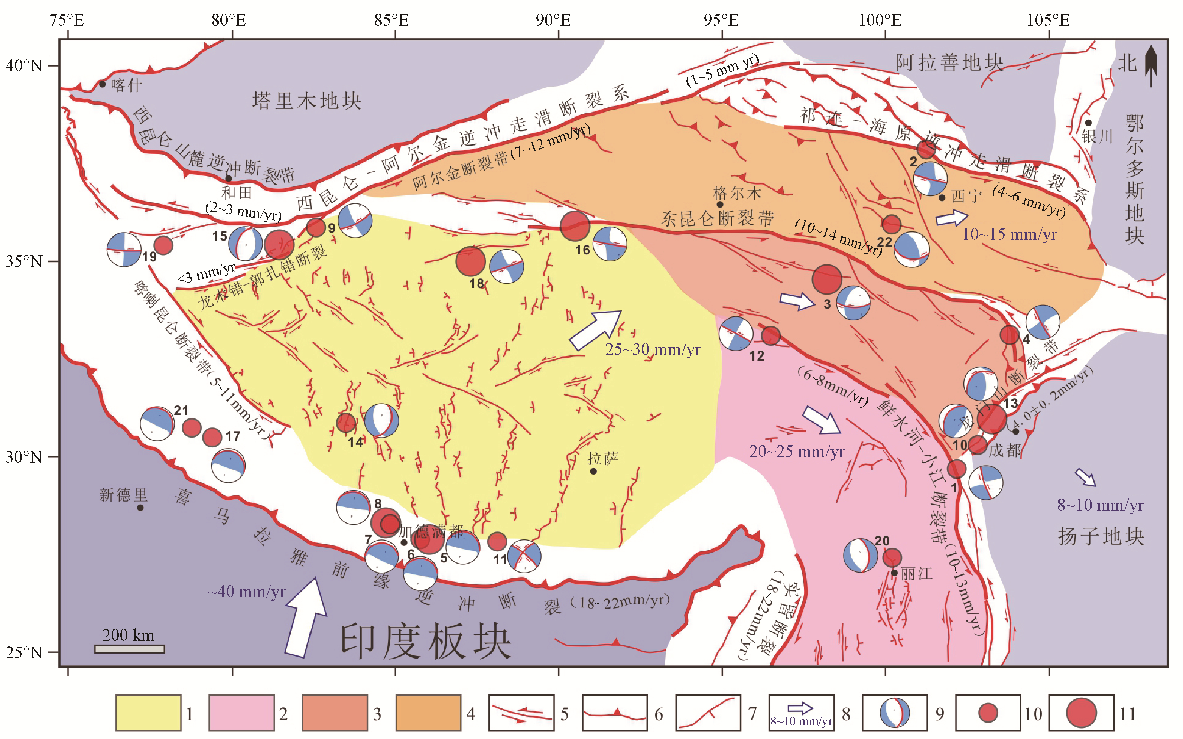
图 1 1990年以来青藏高原发生的MW≥6.0强震的活动特征
地震释放能(E)采用公式logE=5.24+1.44MW进行计算(美国地质调查局,
https://www.usgs.gov/ )
a—强震分布图(DEM数据来源https://www.gscloud.cn/search ;国内的活动断层数据吴中海和周春景,2018;国外活动断层数据为遥感解译);b—强震的震源机制解(数据搜索自https://www.globalcmt.or );c—强震的震级-时间(M-T)分布与地震累计释放能曲线Figure 1. Characteristics of strong earthquakes with MW≥6.0 around the Qinghai-Tibet Plateau since 1990
(a)Distribution map of strong earthquakes (DEM Data from
https://www.gscloud.cn/search ); domestic active fault data from Wu and Zhou, 2018, and foreign active fault data from remote sensing interpretation); (b) Seismic source mechanism solutions of strong earthquakes (data retrieved fromhttps://www.globalcmt.org ); (c) Magnitude-time (M-T) distribution of strong earthquakes and cumulative seismic energy release curve (Dark purple line)
The seismic energy release (E) is calculated using the formula logE=5.24+1.44MW (U.S. Geological Survey,https://www.usgs.gov/programs/earthquake-hazards/earthquake-magnitude-energy-release-and-shaking-intensity ).
图 2 青藏高原及邻区的活动构造变形样式与现今地壳运动状态(Molnar and Lyon-Caen, 1989; Zhang et al., 2004;吴中海和周春景,2018)
Ⅰ—柴达木断块;Ⅱ—巴颜喀拉断块;Ⅲ—藏东-川滇-禅泰断块
Figure 2. Active tectonic deformation patterns and present crustal movement around the Qinghai-Tibet Plateau and adjacent regions (Molnar and Lyon-Caen, 1989; Zhang et al., 2004; Wu and Zhou, 2018)
I-Qaidam Block; Ⅱ-Bayan Har Block; Ⅲ-eastern Tibetan-Sichuan-Yunnan-Chantai Block

图 3 青藏高原主要活动断裂与构造体系以及1990年以来发生的MW≥6.5强震活动(震源机制解和地震数据引自美国地质调查局(USGS)相关网站(
https://earthquake.usgs.gov/ );国内部分活动断层数据吴中海和周春景,2018;国外活动断层数据为遥感解译;断层滑动速率引自Van Der Woerd et al., 2002;Vigny et al., 2003;Cowgill,2007;Ader et al., 2012; Cowgill, 2007; Ader et al., 2012;Chevalier et al., 2012,2017;Liu et al., 2020; Li et al., 2021; 胡萌萌等, 2023)1—青藏高原中南部的近东西向伸展变形构造体系;2—由鲜水河-小江断裂带及藏东-川滇断块区构成的挤出构造体系;3—由东昆仑断裂带、龙门山断裂带及巴颜喀拉断块构成的挤出构造体系;4—由阿尔金-祁连-海原逆冲走滑边界及柴达木断块构成的挤出构造体系;5—走滑断裂;6—逆冲断裂;7—正断层;8—GPS观测的主要断块现今运动状态及速率(数据引自Zhang et al., 2004);9—震源机制解(其中粗线条代表发震断层节面);10—6.5≤MW < 7.0地震;11—7.0≤MW < 8.0地震
Figure 3. Main active faults and tectonic systems around the Qinghai-Tibet Plateau and strong earthquake events with MW≥6.5 since 1990 (seismic source mechanisms and earthquake data from relevant websites of the United States Geological Survey (USGS); some domestic active fault data from Wu and Zhou, 2018; foreign active fault data from remote sensing interpretation; fault slip rates from Van Der Woerd et al., 2002; Vigny et al., 2003; Cowgill, 2007; Ader et al., 2012; Chevalier et al., 2012, 2017; Liu et al., 2020; Li et al., 2021; Hu et al., 2023)
1-Nearly EW-trending extensional deformation tectonic system in the central and southern Qinghai-Tibet Plateau; 2-Extrusion tectonic system composed of the Xianshuihe-Xiaojiang Fault Zone and the eastern Tibetan-Sichuan-Yunnan Block; 3-Extrusion tectonic system composed of the Dongkunlun Fault Zone, Longmenshan Fault Zone, and Bayan Har Block; 4-Extrusion tectonic system composed of the Altyn Tagh-Qilian-Haiyuan thrust and strike-slip boundary and Qaidam Block; 5-Strike-slip faults; 6-Thrust faults; 7-Normal faults; 8-Current movement and velocity of main blocks observed by GPS (data from Zhang et al., 2004); 9-Seismic source mechanisms (thick lines represent fault planes); 10-Earthquakes with 6.5≤MW < 7.0; 11-Earthquakes with 7.0≤MW < 8.0

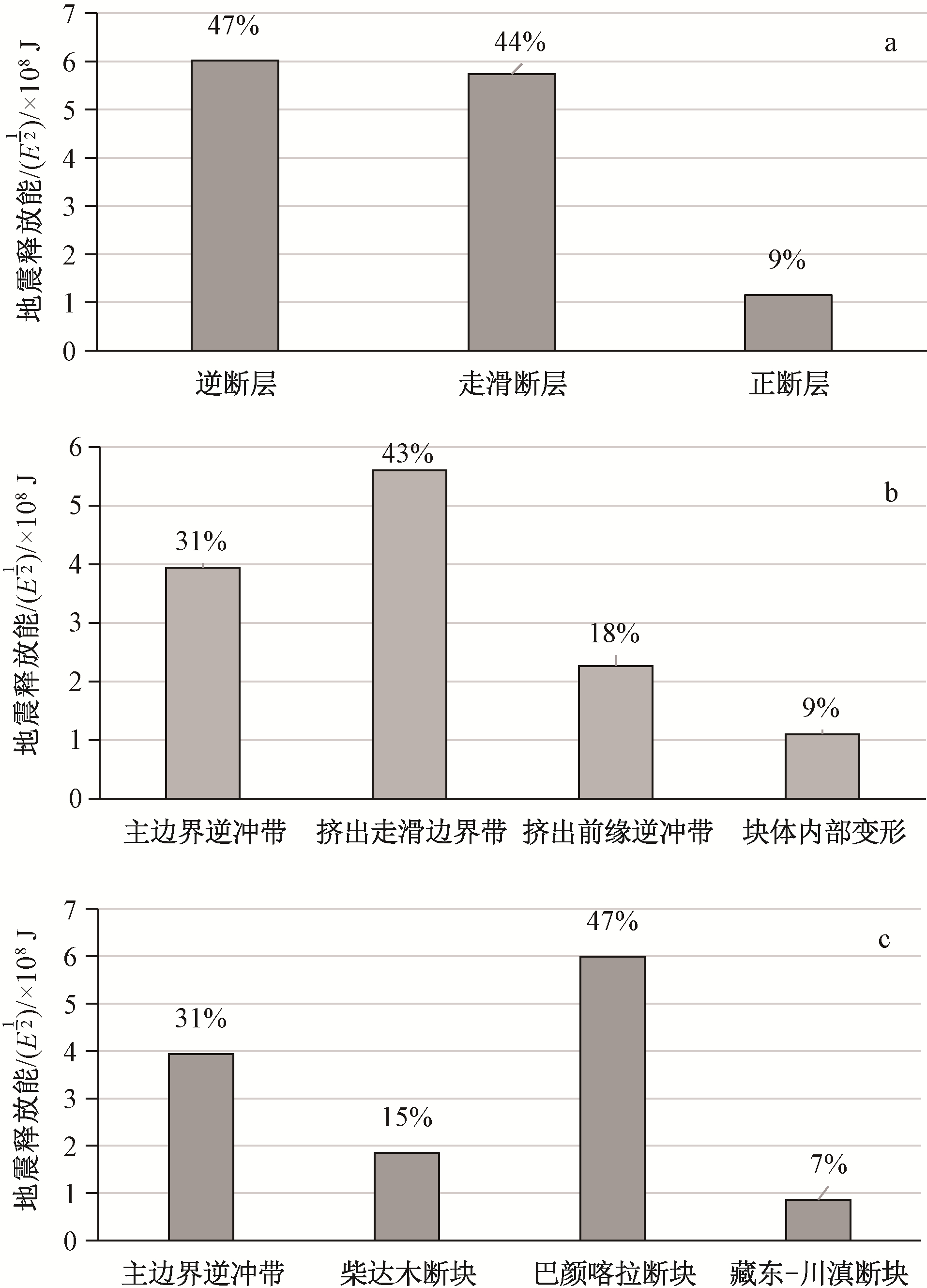
图 4 青藏高原最近一轮强震活动过程中不同类型断裂带和构造单元的地震能释放量统计图
Figure 4. Statistical map of seismic energy release from different types of active fault zones and tectonic units during the recent strong earthquakes with MW≥6.5 around the Qinghai-Tibet Plateau since 1990

图 5 土耳其及邻区公元1999—2023年间的MW>7.0大震序列与陆陆碰撞-挤出构造体系关系图(地震与震源机制解数据源自美国地质调查局(USGS)相关网站
https://earthquake.usgs.gov/ )NAF—北安纳托利亚断裂带;EAF—东安纳托利亚断裂带;DSF—死海断裂;NAT—北爱琴海海槽
a—安纳托利亚及周边板块现今运动状态(Armijo et al., 1999);b—土耳其安纳托利亚及邻区的陆陆碰撞-挤出构造体系及其最近一轮大地震迁移过程Figure 5. Relationship between the sequence of MW>7.0 earthquakes and the continental collision-extrusion tectonic system in Turkey and neighboring areas from 1999 to 2023 (earthquake and seismic source mechanism data sourced from relevant websites of the United States Geological Survey (USGS) at
https://earthquake.usgs.gov/ )(a)Current motion status of Anatolia and surrounding plates (from Armijo et al., 1999); (b) Continental collision-extrusion tectonic system and the latest seismic migration process in Anatolia, Turkey, and neighboring areas

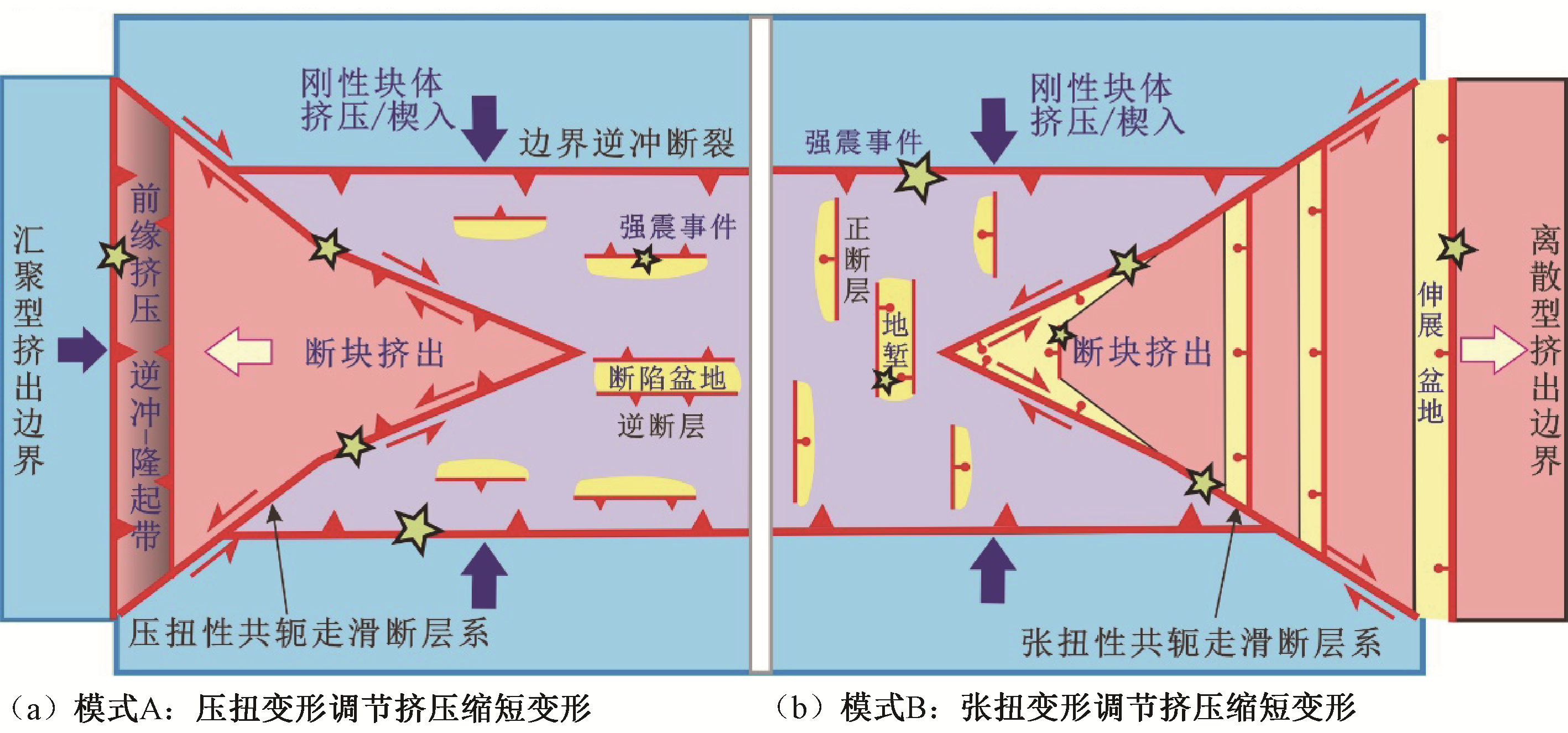
图 6 刚性块体碰撞-挤出活动构造体系及控震特征模式图
Figure 6. Diagram showing the collision-extrusion active tectonic system of rigid block and its earthquake-controlling pattern
表 1 1990年以来青藏高原22次MW≥6.5强震序列及其主要参数
Table 1. Sequence and main parameters of 22 strong earthquakes with MW≥6.5 since 1990 around the Qinghai-Tibet Plateau
序号 发震时期
(年-月-日)仪器震中 地震发生地 矩震级
(MW)震源
深度/
km发震构造 同震震破裂 参考文献 北纬/
(°)东经/
(°)断层名称 断层性质 长度/km 最大位移/m 水平 垂直 1 2022-09-05 29.68 102.24 四川泸定 6.6 12 鲜水河断裂带磨西段 左旋走滑 22 2.23 — 吴伟伟等, 2023; 韩炳权等, 2023 2 2022-01-07 37.83 101.29 青海门源 6.6 13 海原断裂带冷龙岭-托莱山段 左旋走滑 23 3.2 0.5~1.0 韩帅等, 2022 3 2021-05-21 34.60 98.25 青海玛多 7.3 10 东昆仑断裂带分支——昆仑山口-江错断裂东南段 左旋走滑 151~154 2.8~4.8 2.0 盖海龙等, 2021;潘家伟等, 2021; Pan et al., 2022; Ren et al., 2022; Fan et al., 2022 4 2017-08-08 33.19 103.86 四川九寨沟 6.5 9 东昆仑断裂带东段的塔藏断裂 左旋走滑 25~40 0.74~1.1 — 单新建等, 2017; 季灵运等, 2017; 郑绪君等, 2017; 陈威等, 2018; 申文豪等, 2019; 5 2015-05-12 27.81 86.07 尼泊尔珠峰登山者营地 7.3 15 喜马拉雅主前缘逆冲断裂带尼泊尔段 低角度逆冲 40 3.5 (倾滑) 吴中海等, 2015 6 2015-04-26 27.77 86.02 尼泊尔(余震) 6.7 22.91 喜马拉雅主前缘逆冲断裂带尼泊尔段 低角度逆冲 — — — USGS 7 2015-04-25 28.22 84.82 尼泊尔(余震) 6.6 10 喜马拉雅主前缘逆冲断裂带尼泊尔段 低角度逆冲 — — — USGS 8 2015-04-25 28.23 84.73 尼泊尔博克拉 7.8 8.22 喜马拉雅主前缘逆冲断裂带尼泊尔段 低角度逆冲 140 5.3 (倾滑) 吴中海等, 2015 9 2014-02-12 35.91 82.59 新疆于田 6.9 10 阿尔金断裂西南分支:南硝尔库勒断裂、硝尔库勒断裂及阿什库勒断裂 左旋走滑 37.1 0.9 — 袁兆德等, 2021 10 2013-04-20 30.31 102.89 四川芦山 6.6 14 龙门山构造带南段的盲逆断层 逆断层 20~28 1.5~1.6 倾滑) 王卫民等, 2013; 刘成利等, 2013 11 2011-09-18 27.73 88.16 印度锡金邦 6.9 50 喜马拉雅主前缘逆冲断裂带锡金段 走滑断层 — — — USGS 12 2010-04-13 33.17 96.55 青海玉树 6.9 17 玉树-甘孜断裂带隆宝湖-结古镇段 左旋走滑 46 2.4 0.6 周春景等, 2014 13 2008-08-25 30.90 83.52 西藏仲巴县 6.7 12 仲巴-改则裂谷中段的帕龙错地堑 左旋正断层 50 1.15~1.34 (倾滑) 邱江涛等, 2019 14 2008-05-12 31.00 103.32 四川汶川 7.9 19 龙门山构造带的映秀-北川断裂和彭县-灌县断裂 右旋逆断层 240 4.9 6.5 Xu et al., 2009 15 2008-03-20 35.49 81.47 新疆于田 6.6 14 阿尔金断裂西南分支局部拉分处的雪山西麓断裂 左旋正断层 31 1.8 2.0 徐锡伟等, 2011; 16 2001-11-14 35.95 90.54 青海太阳湖 7.8 10 东昆仑断裂系库塞湖-昆仑山口段 左旋走滑 426 8.0 — Xu et al., 2006 17 1999-03-28 30.51 79.40 印度北安恰尔 6.6 15 喜马拉雅主前缘逆冲断裂带印度乌塔兰恰尔邦段 低角度逆冲 — — — USGS 18 1997-11-08 35.07 87.33 西藏玛尼 7.5 33 东昆仑断裂系西段分支——玛尔盖茶卡断裂 左旋走滑 170~185 5.5~7.5 — Wang et al., 2007; Ren and Zhang, 2019 19 1996-11-19 35.35 78.13 新疆和田喀喇昆仑山口 6.9 33 阿尔金断裂系西段分支断裂 左旋走滑 61 — — Wang and Wright, 2012 20 1996-02-03 27.29 100.28 云南丽江大具乡 6.6 11.1 哈巴-玉龙雪山东麓断裂 正断层 33 — 0.78 秦嘉政等, 1997 21 1991-10-19 30.78 78.77 印度代赫里 6.8 10.3 喜马拉雅主前缘逆冲断裂带印度乌塔兰恰尔邦段 低角度逆冲 — — — USGS 22 1990-04-26 35.99 100.25 青海共和 6.5 8.1 青海共和盆地北西西向隐伏逆断层 左旋逆断层 40 0.05 0.79 (倾滑) 赵明等, 1992 注:①地震数据源自美国地质调查局(USGS)相关网站( https://earthquake.usgs.gov/earthquakes/map/ );②数据采集日期为1900-01-01—2023-08-30,震级MW≥6.5,范围为北纬26.037°~40.044°、东经76.025°~106.084°;③地震破裂若具有同震地表破裂数据则使用地表调查结果,否则采用地震反演或InSAR等形变观测的震源区破裂参数 下载: 导出CSV
-
ADER T, AVOUAC J P, JING L Z, et al., 2012. Convergence rate across the Nepal Himalaya and interseismic coupling on the Main Himalayan Thrust: implications for seismic hazard[J]. Journal of Geophysical Research: Solid Earth, 117(B4): B04403, doi: 10.1029/2011JB009071. ARMIJO R, MEYER B, HUBERT A, et al., 1999. Westward propagation of the North Anatolian fault into the northern Aegean: timing and kinematics[J]. Geology, 27(3): 267-270, doi: 10.1130/0091-7613(1999)027<0267:WPOTNA>2.3.CO;2. CHEN W, QIAO X J, LIU G, et al., 2018. Study on the coseismic slip model and Coulomb stress of the 2017 Jiuzhaigou MS7.0 earthquake constrained by GNSS and InSAR measurements[J]. Chinese Journal of Geophysics, 61(5): 2122-2132, doi: 10.6038/cjg2018L0613.(in Chinese with English abstract) CHEVALIER M L, TAPPONNIER P, VAN DER WOERD J, et al., 2012. Spatially constant slip rate along the southern segment of the Karakorum fault since 200 ka[J]. Tectonophysics, 530-531: 152-179, doi: 10.1016/j.tecto.2011.12.014. CHEVALIER M L, PAN J W, LI H B, et al., 2017. First tectonic-geomorphology study along the Longmu-Gozha Co fault system, western Tibet[J]. Gondwana Research, 41: 411-424, doi: 10.1016/j.gr.2015.03.008. COWGILL E, 2007. Impact of riser reconstructions on estimation of secular variation in rates of strike-slip faulting: revisiting the Cherchen River site along the Altyn Tagh Fault, NW China[J]. Earth and Planetary Science Letters, 254(3-4): 239-255, doi: 10.1016/j.epsl.2006.09.015. DENG Q D, ZHANG P Z, RAN Y K, et al., 2003. Active tectonics and earthquake activities in China[J]. Earth Science Frontiers, 10(special issue): 66-73. (in Chinese with English abstract) DENG Q D, GAO X, CHEN G H, et al., 2010. Recent tectonic activity of Bayankala fault-block and the Kunlun-Wenchuan earthquake series of the Tibetan Plateau[J]. Earth Science Frontiers, 17(5): 163-178. (in Chinese with English abstract) DENG Q D, CHENG S P, MA J, et al., 2014. Seismic activities and earthquake potential in the Tibetan Plateau[J]. Chinese Journal of Geophysics, 57(7): 2025-2042, doi: 10.6038/cjg20140701.(in Chinese with English abstract) DEWEY J F, SHACKLETON R M, CHANG C F, et al., 1988. The tectonic evolution of the Tibetan Plateau[J]. Philosophical Transactions of the Royal Society A: Mathematical, Physical and Engineering Sciences, 327(1594): 379-413. ENGLAND P, MOLNAR P, 1990. Right-lateral shear and rotation as the explanation for strike-slip faulting in eastern Tibet[J]. Nature, 344(6262): 140-142. doi: 10.1038/344140a0 FAN X R, ZHANG G H, ZHAO D Z, et al., 2022. Fault geometry and kinematics of the 2021 Mw 7.3 Maduo earthquake from aftershocks and InSAR observations[J]. Frontiers in Earth Science, 10: 993984, doi: 10.3389/feart.2022.993984. GAI H L, YAO S H, YANG L P, et al., 2021. Characteristics and causes of coseismic surface rupture triggered by the "5.22" MS 7.4 Earthquake in Maduo, Qinghai, and their significance[J]. Journal of Geomechanics, 27(6): 899-912, doi: 10.12090/j.issn.1006-6616.2021.27.06.073.(in Chinese with English abstract) HAN B Q, LIU Z J, CHEN B, et al., 2023. Coseismic deformation and slip distribution of the 2022 Luding Mw 6.6 earthquake revealed by InSAR observations[J]. Geomatics and Information Science of Wuhan University, 48(1): 36-46, doi: 10.13203/J.whugis20220636.(in Chinese with English abstract) HAN S, WU Z H, GAO Y, et al., 2022. Surface rupture investigation of the 2022 Menyuan MS 6.9 Earthquake, Qinghai, China: implications for the fault behavior of the Lenglongling fault and regional intense earthquake risk[J]. Journal of Geomechanics, 28(2): 155-168, doi: 10.12090/j.issn.1006-6616.2022013.(in Chinese with English abstract) HU M M, WU Z H, LI J C, et al., 2023. The late Quaternary strike-slip rate of the Qiaojia segment of the Xiaojiang fault zone[J]. Acta Geologica Sinica, 97(1): 16-29, doi: 10.19762/j.cnki.dizhixuebao.2022188.(in Chinese with English abstract) JI L Y, LIU C J, XU J, et al., 2017. InSAR observation and inversion of the seismogenic fault for the 2017 Jiuzhaigou MS7.0 earthquake in China[J]. Chinese Journal of Geophysics, 60(10): 4069-4082, doi: 10.6038/cjg20171032.(in Chinese with English abstract) LEE J S, 1973a. Seismological geology[M]. Beijing: Science Press. (in Chinese) LEE J S, 1973b. An introduction to geomechanics[M]. Beijing: Science Press. (in Chinese) LI H, CHEVALIER M L, TAPPONNIER P, et al., 2021. Block tectonics across western Tibet and multi-millennial recurrence of great earthquakes on the Karakax fault[J]. Journal of Geophysical Research: Solid Earth, 126(12): e2021JB022033, doi: 10.1029/2021JB022033. LIU C L, ZHENG Y, GE C, et al., 2013. Rupture process of the MS7.0 Lushan earthquake, 2013[J]. Science China Earth Sciences, 56(7): 1187-1192, doi: 10.1007/s11430-013-4639-9. LIU J R, REN Z K, ZHENG W J, et al., 2020. Late Quaternary slip rate of the Aksay segment and its rapidly decreasing gradient along the Altyn Tagh fault[J]. Geosphere, 16(6): 1538-1557, doi: 10.1130/GES02250.1. MOLNAR P, TAPPONNIER P, 1978. Active tectonics of Tibet[J]. Journal of Geophysical Research: Solid Earth, 83(B11): 5361-5375. doi: 10.1029/JB083iB11p05361 MOLNAR P, LYON-CAENT H, 1989. Fault plane solutions of earthquakes and active tectonics of the Tibetan Plateau and its margins[J]. Geophysical Journal International, 99(1): 123-153. doi: 10.1111/j.1365-246X.1989.tb02020.x PAN J W, BAI M K, LI C, et al., 2021. Coseismic surface rupture and seismogenic structure of the 2021-05-22 Maduo (Qinghai) MS7.4 earthquake[J]. Acta Geologica Sinica, 95(6): 1655-1670, doi: 10.19762/j.cnki.dizhixuebao.2021166.(in Chinese with English abstract) PAN J W, LI H B, CHEVALIER M L, et al., 2022. Co-seismic rupture of the 2021, MW7.4 Maduo earthquake (northern Tibet): short-cutting of the Kunlun fault big bend[J]. Earth and Planetary Science Letters, 594: 117703, doi: 10.1016/j.epsl.2022.117703. QIN J Z, LIU Z Y, ZHANG J W, 1997. Study on the rupture process of the M7.0 Lijiang earthquake by using seismic scaling[J]. Journal of Seismological Research, 20(1): 47-57. (in Chinese with English abstract) QIU J T, LIU L, LIU C J, et al., 2019. The deformation of the 2008 Zhongba earthquakes and the tectonic movement revealed[J]. Seismology and Geology, 41(2): 481-498, doi: 10.3969/j.issn.0253-4967.2019.02.014.(in Chinese with English abstract) REID H F, 1911. The elastic-rebound theory of earthquakes[J]. Bulletin of the Department of Geology, University of California Publications, 6(19): 413-444. REILINGER R E, MCCLUSKY S C, ORAL M B, et al., 1997. Global Positioning System measurements of present-day crustal movements in the Arabia-Africa-Eurasia plate collision zone[J]. Journal of Geophysical Research: Solid Earth, 102(B5): 9983-9999. doi: 10.1029/96JB03736 REN J J, XU X W, ZHANG G W, et al., 2022. Coseismic surface ruptures, slip distribution, and 3D seismogenic fault for the 2021 Mw 7.3 Maduo earthquake, central Tibetan Plateau, and its tectonic implications[J]. Tectonophysics, 827: 229275, doi: 10.1016/j.tecto.2022.229275. REN Z K, ZHANG Z Q, 2019. Structural analysis of the 1997 Mw 7.5 Manyi earthquake and the kinematics of the Manyi fault, central Tibetan Plateau[J]. Journal of Asian Earth Sciences, 179: 149-164, doi: 10.1016/j.jseaes.2019.05.003. SHAN X J, QU C Y, GONG W Y, et al., 2017. Coseismic deformation field of the Jiuzhaigou MS7.0 earthquake from Sentinel-1A InSAR data and fault slip inversion[J]. Chinese Journal of Geophysics, 60(12): 4527-4536, doi: 10.6038/cjg20171201.(in Chinese with English abstract) SHEN W H, LI Y S, JIAO Q S, et al., 2019. Joint inversion of strong motion and InSAR/GPS data for fault slip distribution of the Jiuzhaigou 7.0 earthquake and its application in seismology[J]. Chinese Journal of Geophysics, 62(1): 115-129, doi: 10.6038/cjg2019L0541.(in Chinese with English abstract) TAPPONNIER P, MOLNAR P, 1977. Active faulting and tectonics in China[J]. Journal of Geophysical Research, 82(20): 2905-2930. doi: 10.1029/JB082i020p02905 TAPPONNIER P, PELTZER G, ARMIJO R, 1986. On the mechanics of the collision between India and Asia[J]. Geological Society, London, Special Publications, 19(1): 113-157. doi: 10.1144/GSL.SP.1986.019.01.07 TAPPONNIER P, RYERSON F J, VAN DER WOERD J, et al., 2001. Long-term slip rates and characteristic slip: keys to active fault behaviour and earthquake hazard[J]. Comptes Rendus de l' Académie des Sciences-Series ⅡA-Earth and Planetary Science, 333(9): 483-494. TAYLOR M, YIN A, RYERSON F J, et al., 2003. Conjugate strike-slip faulting along the Bangong-Nujiang suture zone accommodates coeval east-west extension and north-south shortening in the interior of the Tibetan Plateau[J]. Tectonics, 22(4): 1044, doi: 10.1029/2002TC001361. VAN DER WOERD J, TAPPONNIER P, RYERSON F J, et al., 2002. Uniform postglacial slip-rate along the central 600 km of the Kunlun Fault (Tibet), from 26Al, 10Be, and 14C dating of riser offsets, and climatic origin of the regional morphology[J]. Geophysical Journal International, 148(3): 356-388, doi: 10.1046/j.1365-246x.2002.01556.x. VIGNY C, SOCQUET A, RANGIN C, et al., 2003. Present-day crustal deformation around Sagaing fault, Myanmar[J]. Journal of Geophysical Research: Solid Earth, 108(B11): 2533, doi: 10.1029/2002JB001999. WANG H, XU C J, GE L L, 2007. Coseismic deformation and slip distribution of the 1997 MW7.5 Manyi, Tibet, earthquake from InSAR measurements[J]. Journal of Geodynamics, 44(3-5): 200-212, doi: 10.1016/j.jog.2007.03.003. WANG H, WRIGHT T J, 2012. Satellite geodetic imaging reveals internal deformation of western Tibet[J]. Geophysical Research Letters, 39(7): L07303. WANG W M, HAO J L, YAO Z X, 2013. Preliminary result for rupture process of Apr. 20, 2013, Lushan Earthquake, Sichuan, China[J]. Chinese Journal of Geophysics, 56(4): 1412-1417, doi: 10.6038/cjg20130436.(in Chinese with English abstract) WU W W, MENG G J, LIU T, et al., 2023. Coseismic displacement field and slip distribution of the 2022 Luding M6.8 earthquake derived from GNSS observations[J]. Chinese Journal of Geophysics, 66(6): 2306-2321, doi: 10.6038/cjg2023Q0826.(in Chinese with English abstract) WU Z H, YE P S, BAROSH P J, et al., 2011. The October 6, 2008 Mw 6.3 magnitude Damxung earthquake, Yadong-Gulu rift, Tibet, and implications for present-day crustal deformation within Tibet[J]. Journal of Asian Earth Sciences, 40(4): 943-957, doi: 10.1016/j.jseaes.2010.05.003. WU Z H, ZHAO G M, 2013. The earthquake prediction status and related problems: a review[J]. Geological Bulletin of China, 32(10): 1493-1512. (in Chinese with English abstract) doi: 10.3969/j.issn.1671-2552.2013.10.002 WU Z H, ZHAO G M, LONG C X, et al., 2014. The seismic hazard assessment around South-East area of Qinghai-Xizang Plateau: a preliminary results from active tectonics system analysis[J]. Acta Geologica Sinica, 88(8): 1401-1416. (in Chinese with English abstract) WU Z H, LONG C X, FAN T Y, et al., 2015. The arc rotational-shear active tectonic system on the southeastern margin of Tibetan Plateau and its dynamic characteristics and mechanism[J]. Geological Bulletin of China, 34(1): 1-31. (in Chinese with English abstract) WU Z H, ZHAO G M, LIU J, 2016. Tectonic genesis of the 2015 Ms8.1 Nepal great earthquake and its influence on future strong earthquake tendency of Tibetan Plateau and its adjacent region[J]. Acta Geologica Sinica, 90(6): 1062-1085. (in Chinese with English abstract) doi: 10.3969/j.issn.0001-5717.2016.06.002 WU Z H, ZHOU C J, 2018. Distribution map of active faults in China and its adjacent sea area (1 ∶ 5, 000, 000)[M]//HAO A B, LI R M. Atlas sets of geological environment of China. Beijing: Geological Publishing House. (in Chinese) WU Z H, HU M M, 2019. Neotectonics, active tectonics and earthquake geology: terminology, applications and advances[J]. Journal of Geodynamics, 127: 1-15. doi: 10.1016/j.jog.2019.01.007 WU Z H, 2022. Active faults and engineering applications Ⅰ: definition and classification[J]. Journal of Earth Sciences and Environment, 44(6): 922-947, doi: 10.19814/j.jese.2022.09049.(in Chinese with English abstract) WU Z H, 2024. The MW≥6.5 strong earthquake events since 1990 around the Tibetan Plateau and control-earthquake effect of active tectonic system[J]. Progress in Earthquake Sciences, 54(1): 10-24, doi: 10.19987/j.dzkxjz.2023-170.(in Chinese with English abstract) WU Z H, HU M M, 2024. Definitions, classification schemes for active faults, and their application[J]. Geosciences, 14(3): 68, doi: 10.3390/geosciences14030068. XU X W, YU G H, KLINGER Y, et al., 2006. Reevaluation of surface rupture parameters and faulting segmentation of the 2001 Kunlunshan earthquake (Mw7.8), northern Tibetan Plateau, China[J]. Journal of Geophysical Research: Solid Earth, 111(B5): B05316, doi: 10.1029/2004JB003488. XU X W, WEN X Z, YU G H, et al., 2009. Coseismic reverse- and oblique-slip surface faulting generated by the 2008 Mw 7.9 Wenchuan earthquake, China[J]. Geology, 37(6): 515-518, doi: 10.1130/G25462A.1. XU X W, TAN X B, WU G D, et al., 2011. Surface rupture features of the 2008 Yutian MS7.3 earthquake and its tectonic nature[J]. Seismology and Geology, 33(2): 462-471. (in Chinese with English abstract) YUAN Z D, LIU-ZENG J, LI X, et al., 2021. Detailed mapping of the surface rupture of the 12 February 2014 Yutian MS7.3 earthquake, Altyn Tagh fault, Xinjiang, China[J]. Science China Earth Sciences, 64(1): 127-147, doi: 10.1007/s11430-020-9673-6. ZHANG J L, REN J W, CHEN C Y, et al., 2014. The Late Pleistocene activity of the eastern part of east Kunlun fault zone and its tectonic significance[J]. Science China Earth Sciences, 57(3): 439-453, doi: 10.1007/s11430-013-4759-2. ZHANG P Z, DENG Q D, ZHANG G M, et al., 2003. Active tectonic blocks and strong earthquakes in the continent of China[J]. Science in China Series D: Earth Sciences, 46(2): 13-24. ZHANG P Z, SHEN Z K, WANG M, et al., 2004. Continuous deformation of the Tibetan Plateau from global positioning system data[J]. Geology, 32(9): 809-812, doi: 10.1130/G20554.1. ZHANG P Z, DENG Q D, ZHANG Z Q, et al., 2013. Active faults, earthquake hazards and associated geodynamic processes in continental China[J]. Scientia Sinica Terrae, 43(10): 1607-1620. (in Chinese) doi: 10.1360/zd-2013-43-10-1607 ZHAO G M, WU Z H, LIU J, et al., 2019. The time space distribution characteristics and migration law of large earthquakes in the Indiam-Eurasian plate collision deformation area[J]. Journal of Geomechanics, 25(3): 324-340, doi: 10.12090/j.issn.1006-6616.2019.25.03.030.(in Chinese with English abstract) ZHAO G M, WU Z H, LIU J, 2020. The types, characteristics and mechanism of seismic migration[J]. Journal of Geomechanics, 26(1): 13-32, doi: 10.12090/j.issn.1006-6616.2020.26.01.002.(in Chinese with English abstract) ZHAO M, CHEN Y T, GONG S W, et al., 1992. Inversion of focal mechanism of the Gonghe earthquake in April 26, 1990 using leveling data[J]. Crustal Deformation and Earthquake, 12(4): 1-11. (in Chinese with English abstract) ZHENG W J, ZHANG P Z, YUAN D Y, et al., 2019. Basic characteristics of active tectonics and associated geodynamic processes in continental China[J]. Journal of Geomechanics, 25(5): 699-721, doi: 10.12090/j.issn.1006-6616.2019.25.05.062.(in Chinese with English abstract) ZHENG X J, ZHANG Y, WANG R J, 2017. Estimating the rupture process of the 8 August 2017 Jiuzhaigou earthquake by inverting strong-motion data with IDS method[J]. Chinese Journal of Geophysics, 60(11): 4421-4430, doi: 10.6038/cjg20171128.(in Chinese with English abstract) ZHOU C J, WU Z H, NIMA C R, et al., 2014. Structural analysis of the co-seismic surface ruptures associated with the Yushu Ms7.1 earthquake, Qinghai Province[J]. Geological Bulletin of China, 33(4): 551-566, doi: 10.3969/j.issn.1671-2552.2014.04.011.(in Chinese with English abstract) 陈威, 乔学军, 刘刚, 等, 2018. 基于GNSS与InSAR约束的九寨沟MS7.0地震滑动模型及其库仑应力研究[J]. 地球物理学报, 61(5): 2122-2132, doi: 10.6038/cjg2018L0613. 邓起东, 张培震, 冉勇康, 等, 2003. 中国活动构造与地震活动[J]. 地学前缘, 10(特刊): 66-73. https://www.cnki.com.cn/Article/CJFDTOTAL-DXQY2003S1011.htm 邓起东, 高翔, 陈桂华, 等, 2010. 青藏高原昆仑—汶川地震系列与巴颜喀喇断块的最新活动[J]. 地学前缘, 17(5): 163-178. https://www.cnki.com.cn/Article/CJFDTOTAL-DXQY201005017.htm 邓起东, 程绍平, 马冀, 等, 2014. 青藏高原地震活动特征及当前地震活动形势[J]. 地球物理学报, 57(7): 2025-2042, doi: 10.6038/cjg20140701. 盖海龙, 姚生海, 杨丽萍, 等, 2021. 青海玛多"5·22"MS7.4级地震的同震地表破裂特征、成因及意义[J]. 地质力学学报, 27(6): 899-912, doi: 10.12090/j.issn.1006-6616.2021.27.06.073. 韩炳权, 刘振江, 陈博, 等, 2023.2022年泸定Mw 6.6地震InSAR同震形变与滑动分布[J]. 武汉大学学报(信息科学版), 48(1): 36-46, doi: 10.13203/J.whugis20220636. 韩帅, 吴中海, 高扬, 等, 2022.2022年1月8日青海门源MS 6.9地震地表破裂考察的初步结果及对冷龙岭断裂活动行为和区域强震危险性的启示[J]. 地质力学学报, 28(2): 155-168, doi: 10.12090/j.issn.1006-6616.2022013. 胡萌萌, 吴中海, 李家存, 等, 2023. 小江断裂带巧家段晚第四纪走滑速率研究[J]. 地质学报, 97(1): 16-29, doi: 10.19762/j.cnki.dizhixuebao.2022188. 季灵运, 刘传金, 徐晶, 等, 2017. 九寨沟MS7.0地震的InSAR观测及发震构造分析[J]. 地球物理学报, 60(10): 4069-4082, doi: 10.6038/cjg20171032. 李四光, 1973a. 地震地质[M]. 北京: 科学出版社. 李四光, 1973b. 地质力学概论[M]. 北京: 科学出版社. 刘成利, 郑勇, 葛粲, 等, 2013.2013年芦山7.0级地震的动态破裂过程[J]. 中国科学: 地球科学, 43(6): 1020-1026. https://www.cnki.com.cn/Article/CJFDTOTAL-JDXK201306010.htm 潘家伟, 白明坤, 李超, 等, 2021.2021年5月22日青海玛多MS7.4地震地表破裂带及发震构造[J]. 地质学报, 95(6): 1655-1670, doi: 10.19762/j.cnki.dizhixuebao.2021166. 秦嘉政, 刘祖荫, 张俊伟, 1997. 用地震标定律研究丽江7.0级地震的破裂过程[J]. 地震研究, 20(1): 47-57. https://www.cnki.com.cn/Article/CJFDTOTAL-DZYJ701.006.htm 邱江涛, 刘雷, 刘传金, 等, 2019.2008年仲巴地震形变及其揭示的构造运动[J]. 地震地质, 41(2): 481-498, doi: 10.3969/j.issn.0253-4967.2019.02.014. 单新建, 屈春燕, 龚文瑜, 等, 2017.2017年8月8日四川九寨沟7.0级地震InSAR同震形变场及断层滑动分布反演[J]. 地球物理学报, 60(12): 4527-4536, doi: 10.6038/cjg20171201. 申文豪, 李永生, 焦其松, 等, 2019. 联合强震记录和InSAR/GPS结果的四川九寨沟7.0级地震震源滑动分布反演及其地震学应用[J]. 地球物理学报, 62(1): 115-129, doi: 10.6038/cjg2019L0541. 王卫民, 郝金来, 姚振兴, 2013.2013年4月20日四川芦山地震震源破裂过程反演初步结果[J]. 地球物理学报, 56(4): 1412-1417, doi: 10.6038/cjg20130436. 吴伟伟, 孟国杰, 刘泰, 等, 2023.2022年泸定6.8级地震GNSS同震形变场及其约束反演的破裂滑动分布[J]. 地球物理学报, 66(6): 2306-2321, doi: 10.6038/cjg2023Q0826. 吴中海, 赵根模, 2013. 地震预报现状及相关问题综述[J]. 地质通报, 32(10): 1493-1512. https://www.cnki.com.cn/Article/CJFDTOTAL-ZQYD201310002.htm 吴中海, 赵根模, 龙长兴, 等, 2014. 青藏高原东南缘现今大震活动特征及其趋势: 活动构造体系角度的初步分析结果[J]. 地质学报, 88(8): 1401-1416. https://www.cnki.com.cn/Article/CJFDTOTAL-DZXE201408004.htm 吴中海, 龙长兴, 范桃园, 等, 2015. 青藏高原东南缘弧形旋扭活动构造体系及其动力学特征与机制[J]. 地质通报, 34(1): 1-31. https://www.cnki.com.cn/Article/CJFDTOTAL-ZQYD201501002.htm 吴中海, 赵根模, 刘杰, 2016.2015年尼泊尔Ms8.1地震构造成因及对青藏高原及邻区未来强震趋势的影响[J]. 地质学报, 90(6): 1062-1085. https://www.cnki.com.cn/Article/CJFDTOTAL-DZXE201606003.htm 吴中海, 周春景, 2018. 中国及毗邻海区活动断裂分布图(1 ∶ 500万)[M]//郝爱兵, 李瑞敏. 中国地质环境图系(图件编号: 00-01-05). 北京: 地质出版社. 吴中海, 2022. 活断层与工程应用I: 定义与分类[J]. 地球科学与环境学报, 44(6): 922-947, doi: 10.19814/j.jese.2022.09049. 吴中海, 2024. 青藏高原1990年以来的MW≥6.5强震事件及活动构造体系控震效应[J]. 地震科学进展, 54(1): 10-24, doi: 10.19987/j.dzkxjz.2023-170. 徐锡伟, 谭锡斌, 吴国栋, 等, 2011.2008年于田MS7.3地震地表破裂带特征及其构造属性讨论[J]. 地震地质, 33(2): 462-471. https://www.cnki.com.cn/Article/CJFDTOTAL-DZDZ201102024.htm 袁兆德, 刘静, 李雪, 等, 2021.2014年新疆于田MS7.3地震地表破裂带精细填图及其破裂特征[J]. 中国科学: 地球科学, 51(2): 276-298, doi: 10.1360/SSTe-2020-0100. 张军龙, 任金卫, 陈长云, 等, 2014. 东昆仑断裂带东部晚更新世以来活动特征及其大地构造意义[J]. 中国科学: 地球科学, 44(4): 654-667. https://www.cnki.com.cn/Article/CJFDTOTAL-JDXK201404008.htm 张培震, 邓起东, 张国民, 等, 2003. 中国大陆的强震活动与活动地块[J]. 中国科学(D辑), 33(S1): 12-20. https://www.cnki.com.cn/Article/CJFDTOTAL-JDXK200407000.htm 张培震, 邓起东, 张竹琪, 等, 2013. 中国大陆的活动断裂、地震灾害及其动力过程[J]. 中国科学: 地球科学, 43(10): 1607-1620. https://www.cnki.com.cn/Article/CJFDTOTAL-JDXK201310005.htm 赵根模, 吴中海, 刘杰, 等, 2019. 印度-欧亚板块碰撞变形区的大地震时空分布特征与迁移规律[J]. 地质力学学报, 25(3): 324-340, doi: 10.12090/j.issn.1006-6616.2019.25.03.030. 赵根模, 吴中海, 刘杰, 2020. 地震迁移的类型、特征及机制讨论[J]. 地质力学学报, 26(1): 13-32, doi: 10.12090/j.issn.1006-6616.2020.26.01.002. 赵明, 陈运泰, 巩守文, 等, 1992. 用水准测量资料反演1990年青海共和地震的震源机制[J]. 地壳形变与地震, 12(4): 1-11. https://www.cnki.com.cn/Article/CJFDTOTAL-DKXB199204000.htm 郑文俊, 张培震, 袁道阳, 等, 2019. 中国大陆活动构造基本特征及其对区域动力过程的控制[J]. 地质力学学报, 25(5): 699-721, doi: 10.12090/j.issn.1006-6616.2019.25.05.062. 郑绪君, 张勇, 汪荣江, 2017. 采用IDS方法反演强震数据确定2017年8月8日九寨沟地震的破裂过程[J]. 地球物理学报, 60(11): 4421-4430, doi: 10.6038/cjg20171128. 周春景, 吴中海, 尼玛次仁, 等, 2014. 青海玉树Ms7.1级地震同震地表破裂构造[J]. 地质通报, 33(4): 551-566, doi: 10.3969/j.issn.1671-2552.2014.04.011. -

 下载:
下载:


计量
- 文章访问数: 1652
- HTML全文浏览量: 305
- PDF下载量: 198
- 被引次数: 0
