

RESEARCH ON DYNAMIC CHARACTERISTICS OF THE KALAYAGAQI LANDSLIDE IN YINING COUNTRY, XINJIANG
-
摘要: 通过对高速远程黄土滑坡动力学特征的研究,提出黄土高速远程滑坡空间预测的模拟方法。以新疆伊宁县喀拉亚尕奇黄土滑坡为例,基于野外地质调查和无人机航拍影像图,结合滑坡研究区的工程地质条件,分析了该滑坡的基本特征和形成条件。研究发现,该滑坡的主要诱发因素是冰雪融水入渗,其孕灾模式主要为四个阶段:后缘拉裂阶段,黄土节理冻胀扩展阶段,融雪入渗失稳阶段,高速下滑阶段。同时利用Rapid模型对滑坡运动全过程进行模拟,计算得到滑坡运动持续时间为26 s,最大运动速度达到22 m/s,堆积体的平均厚度达到5 m等运动特征要素,结果表明Rapid模型可以较好的模拟分析黄土高速远程滑坡动力学效应,为黄土地区类似滑坡的成灾机理和动力学效应分析提供参考。Abstract: Based on the study of dynamic characteristics of high speed long distance loess landslide, a simulation method for spatial prediction of high speed long distance loess landslide is proposed. Taking the Kalayagaqi loess landslide as an example, according to the field geological survey and aerial photograph images of the unmanned aerial vehicle, combined with the engineering geological conditions of the landslide research area, the basic features and formation conditions of the landslide are analysed. The study shows that the main inducing factor of the landslide is the infiltration of melted ice water, and there are mainly four disaster-inducing stages:Firstly, because of the concentration of stress at the top of the mountain, crack phenomenon appears in the trailing of landslide; Secondly, the mountain is covered with snow, and the loess joint fissure are enlarged by the effect of frost heave. Thirdly, due to the rising temperature and the infiltration of melted ice water, the sliding resistance of the landslide is gradually reduced. At last, the landslide lost its stability and slips at a high speed. The Rapid model was used to simulate the whole process of the kalayagaqi landslide. The results show that the duration of the landslide movement is 26 s, the maximum motion speed is up to 22 m/s and the average thickness of the accumulation body reaches 5 m. It proves that the Rapid model can be used to simulate and analyze the dynamic effect of high speed long distance loess landslide, providing reference for the analysis of the disaster-inducing mechanism and dynamic effect of similar landslides in the loess area.
-
Key words:
- loess landslide /
- disaster-inducing mechanism /
- kinematics /
- numerical simulation
-
0. 引言
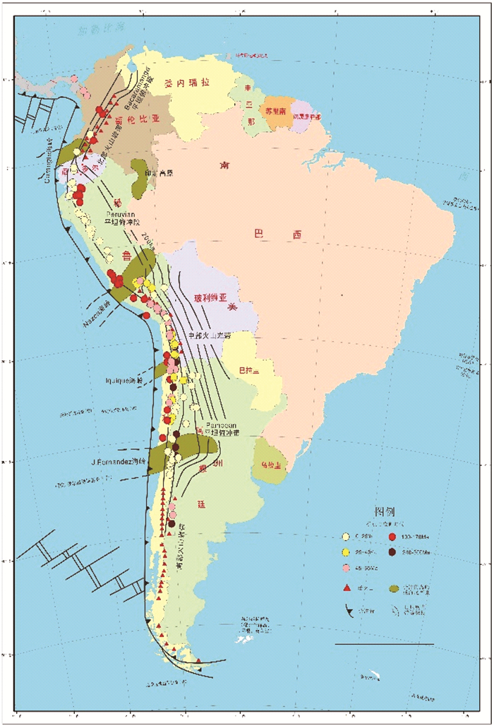
斑岩型矿床是世界上铜、钼和铼等金属最重要来源, 环太平洋地区是世界上最主要的斑岩铜矿带[1-2],仅南美洲安第斯带的智利、秘鲁就拥有El Teniente,Chuquicamata、Río Blanco-Los Bronces、La Escondida、Los Pelambres-El Pachón、Rosario、Radomiro Tomic、El Salvador、Toki、La Granja、Cujaone、Cerro Casala、Minas Congas等众多千万吨以上的巨型斑岩铜(金)矿,探明储量超过2.6亿吨,占全球铜探明储量的37.7%,产量占全球铜产量的39%(世界矿产资源年评,2014),其中El Teniente铜储量约为9千多万吨,且含金超过2500吨[2-7]。对安第斯带斑岩型矿床的研究,一直是地质学家研究的热点。
文章依托中国地质调查局“全球矿产资源信息系统”和有关项目,试图通过总结南美安第斯带斑岩型铜(金-钼)矿床的时空分布特征,为认识安第斯带斑岩型矿床成矿地质特征、成矿规律等提供参考。
1. 安第斯带斑岩型铜(金-钼)矿床时空分布
斑岩型矿床是南美安第斯带最重要的铜(金-钼)矿床类型。斑岩铜矿原指产于强烈绢云母化和石英化中酸性斑岩里的细脉浸染型铜矿,目前多数学者认为斑岩铜矿是指与花岗质斑状侵入岩相关的,且钾质硅酸盐蚀变普遍发育于岩体内部,岩浆期后热液形成的细脉浸染状和角砾状硫化物矿床,还包括部分矽卡岩矿体[8],也包括与斑岩型矿床有密切时空和成因联系的叠加其上的浅成低温热液金银铜矿床[9]。
根据基底组成、构造-岩浆演化、板块俯冲形式和成矿作用的不同,安第斯造山带自北而南划分为3个次级构造单元,即:北安第斯带、中安第斯带和南安第斯带,北、中安第斯带构造分界约在5°S左右的厄瓜多尔的瓜亚基尔湾,中、南安第斯带构造分界为39°S左右的智利南部的瓦尔迪维亚(Valdivia)[10-11]。
在整个安第斯带上,斑岩型铜矿带长约6000 km,呈线性多条带状分布,与安第斯造山带平行(图 1),每个斑岩铜成矿带的发育都受限于不同的成矿期[12]。从目前勘探和开发情况看,中安第斯段一直是铜矿勘探和开采的热点地区,特别是秘鲁南部—智利中北部和阿根廷西北部地区,发现了一大批具有巨型规模的斑岩铜矿; 北安第斯段的斑岩铜矿也逐渐受到重视,南安第斯段的斑岩铜潜力很小[1, 13]。

1.1 北安第斯段
明显分出三条斑岩铜矿带,北部主要分布在6°N~9°N之间,以哥伦比亚的Acandi、Pantanos-Pegadorcito、Murindo等为代表,成矿时代在48.7~42 Ma,属于始新世;向南(在5°N~5°S之间)形成大致与造山带平行的两条斑岩铜矿带,西侧以厄瓜多尔的Junin、Gaby-Papa Grande及秘鲁的Rio Blanco等为代表,成矿时代在中新世(20~6.5 Ma);东侧以厄瓜多尔的Mirador、Panantza等为代表,成矿时代是中晚侏罗世(150~170 Ma)。
1.2 中安第斯段
1.2.1 秘鲁中北部(5°S~12°S之间)
该区存在一条长1200 km,宽50~100 km的斑岩型铜(金-钼)矿带,沿西科迪勒拉延伸,成矿时代为中新世-上新世(20~5 Ma)。该带著名的巨型斑岩铜(金-钼)矿床有Toromocho、EI Galeno、Minas Conga及矽卡岩型铜(金)矿床Antamina。
1.2.2 秘鲁南部(12°S~18°S之间)
该区存在3条斑岩铜矿带,沿海岸科迪勒拉延伸的以Zafranal、Almacen、Anita de Tibilos等为代表,带宽在30 km左右,成矿时代为晚侏罗世—早白垩世(160~100 Ma);第二条带分布在14°S~16°S之间,成矿时代是始新世晚期—渐新世(40~20 Ma),以Las Bambas、Tintaya、Chalcobamba等为代表;第三条带分布在16°S~18°S之间,成矿时代为古新世(62~50 Ma),这是秘鲁最著名的铜矿集中区,象Cuajone、Quellaveco、Toquepala、Cerro Verde/Santa Rosa等巨型斑岩矿床都分布在这里。
1.2.3 秘鲁南部—智利中北部(含阿根廷西北部)(12°S~39°S之间)
这是安第斯带斑岩型铜(金-钼)矿床发现数量多、分布相对最集中、矿床规模达巨型数量也最多的地段,有5条斑岩铜矿带,以古新世—早始新世带、中始新世—早渐新世带和中新世—早上新世带最为重要。
(1) 成矿时代最老(250~292 Ma)的斑岩铜矿出现在二叠纪,沿智利和阿根廷西部边界分布(20°S~40°S),矿床规模不大。
(2) 中生代晚期(100~160 Ma)的斑岩铜矿发育在13°S~34°S的海岸科迪勒拉,断续延长2300 km,带宽在30 km左右,该带以众多铁氧化物型Cu-Au矿床和曼陀型(Manto)铜矿床为主,主要有Raul-Condestable、Manto verde和Michilla、Mantos Blancos、El Soldado、Lo Aguirre等。
(3) 古新世—早始新世(45~65 Ma)的斑岩铜矿主要产于16°S~32°S,位于西科迪勒拉西侧斜坡,铜矿带平均宽度为30~50 km。该带最著名的矿床有秘鲁的Cerro Verde-Santa Rosa、Cuajone、Quellaveco、Toquepala及智利的Cerro Colorado、Spence矿床,以高Mo,低Au为特征。
(4) 中始新世—早渐新世(45~30 Ma)的斑岩铜矿带从秘鲁南部的13°30′S向南一直延伸到智利北部31°S,全长约2500 km,在秘鲁南部带宽约130 km,在智利北部变为30~50 km宽,而在24.6°S的阿根廷西北部该带宽约150 km。在秘鲁南部矿带位于东、西科迪勒拉之间的坳陷地带,矿化与Andahuaylas-Yauri钙碱性岩基有时空关联,典型矿床有Antapaccay、Coroccohuayco、Tintaya、Los Chancas和Cotabarnbas等;在智利北部,从20°S~26°S之间,该带长>1000 km,产于Domeyko科迪勒拉,斑岩铜矿床位于Domeyko断裂系统之上或附近,受该断裂体系控制明显[15-18],典型矿床有Chuquicamata、Potrerillos、EI Salvador、Escondida、Quebrada Blanca、Zaldivar、Radomiro Tomic、EI Abra等。
(5) 中新世-早上新世(23~4 Ma)的斑岩铜矿带位于智利中部—阿根廷中部之间,可细分三个亚带:智利中部亚带位于32°S~35°S之间,沿主科迪勒拉延伸约400 km,矿床形成时代约12~4 Ma,主要矿床有Los Pelambres、Rio Blanco-Los Bronces和EI Teniente;Maricunga-El Indio亚带位于智利中部亚带北部,26°S~31°S之间,矿床形成时代约12~4 Ma,以斑岩铜金矿为主,如Cerro Casale等;Farallon Negro亚带位于阿根廷西北部的安第斯山脉前陆地带,24°S~26°S之间,矿床形成时代约10~5 Ma,以斑岩铜(金-钼)矿为主,如Bajo dela Alumbrera、Agua Rica和Los Pelambres-El Pachon等。
在中安第斯段,从秘鲁南部—智利中部斑岩型铜(金-钼)矿床分布看,铜矿带的成矿时代具有向东逐渐年轻的倾向,这可能是由于在大陆边缘受一系列长期大洋板块俯冲作用的影响[19~21]。
从安第斯带斑岩型铜(金-钼)矿床时空分布看,矿床成矿时代大体可分为6期,其中,晚古生代冈瓦纳造山旋回2期:二叠纪(300~250 Ma)和中晚侏罗世(175~145 Ma);中—新生代安第斯造山旋回4期:早白垩世(140~100 Ma)、古新世—始新世(65~50 Ma)、始新世晚期—渐新世(43~31 Ma)和中新世中期—上新世(12~4 Ma)。冈瓦纳造山旋回的两期斑岩铜矿化规模都较小,分布局限,其中,二叠纪的斑岩铜矿仅发育在智利东部和阿根廷西北部[19];中晚侏罗世的斑岩铜矿主要发育在厄瓜多尔和哥伦比亚一带。
安第斯造山旋回是该区斑岩型铜矿形成的主要时期,最主要的是始新世晚期-渐新世(43~31 Ma)和中新世中期—上新世(12~4 Ma)时期,主要产在中安第斯段,以秘鲁南部—智利中北部(含阿根廷西北部)为主。
1.3 南安第斯段
该段中—新生代火山-岩浆活动强度比中安第斯段相对较弱,岩性多偏基性,以玄武质或玄武安山质为主[10]。成矿作用也与中安第斯段存在较大差异,基本没有斑岩型矿床存在[12],矿床类型以浅成低温热液型的金、银矿床和喷流沉积型(Sedex)Zn-Pb-Ba-Ag多金属矿床为主。
2. 安第斯带斑岩型铜矿床形成时期
安第斯带已知斑岩铜矿床的铜资源量为5.9亿吨(表 1),其中,始新世—渐新世形成的斑岩铜矿为2.69亿吨,约占已发现铜资源量的45.4%,中新世—上新世形成的斑岩铜矿为1.949亿吨,约占已发现铜资源量的32.9%,这两期形成的斑岩铜矿占已发现的全部铜资源量的78.3%,表明始新世—渐新世、中新世—上新世是南美最主要的2个斑岩铜矿形成时期。
表 1 安第斯带各斑岩铜矿成矿期已发现的铜资源量Table 1. Copper resources discovered during the ore-forming period of various porphyry copper deposits in the Andes belt成矿时代 铜资源量(万吨) 占已发现资源量的比例 新生代 中新世—上新世 19490 32.9% 渐新世—中新世 5110 8.6% 始新世—渐新世 26900 45.4% 古新世—始新世 6500 11.0% 中生代 早白垩世 155 0.3% 中晚侏罗世 900 1.5% 古生代 二叠纪 200 0.3% 合计 59255 100% 资料来源:USGS Open-File Report 2008-1253[22] 3. 结论
南美安第斯带是全球斑岩型铜(金-钼)矿床赋存最丰富的地区,矿带呈线性多条带状分布,与安第斯造山带平行。秘鲁中南部—智利中北部(含阿根廷西北部)为安第斯带斑岩型铜(金-钼)矿床发现数量最多、分布最集中、矿床规模达巨型数量最多的地段。斑岩矿床成矿时代有晚古生代冈瓦纳造山旋回两期和中—新生代安第斯造山旋回4期,以始新世晚期—渐新世和中新世中期—上新世最为重要。
致谢: 文章图件由中国地质大学(北京)硕士研究生郑瑜林清绘完成,在此深表谢意。 -
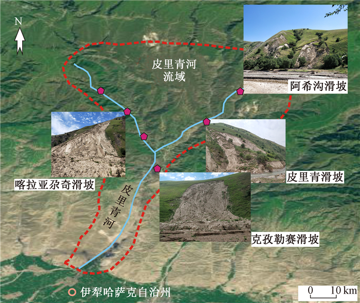
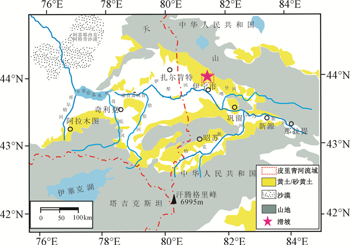
图 3 皮里青河流域滑坡分布示意图
Figure 3. Schematic diagram of landslide distribution in the Piliqing River Basin
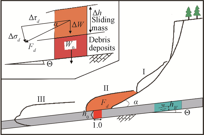

图 6 滑体平均速度随时间变化图
Figure 6. Variation figure of average velocity of the landslide with time
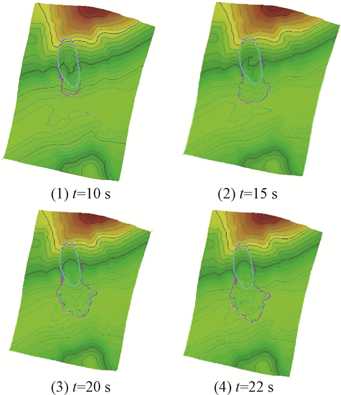
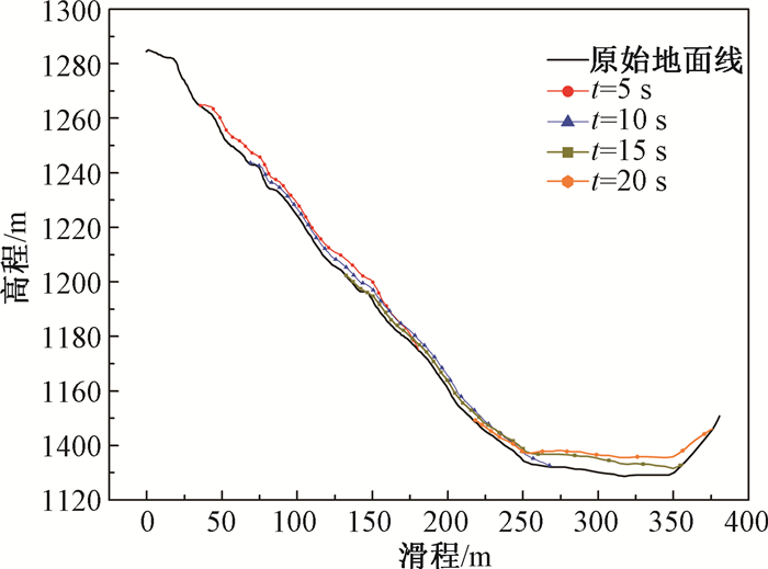
图 7 不同时刻滑坡堆积形态变化图
Figure 7. Variation diagram of landslide accumulation form at different time
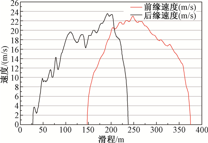
图 8 滑体前后缘运动速度图
Figure 8. Velocity chart of the front and the rear edge of the landslide
表 1 喀拉亚尕奇滑坡Rapid模型参数
Table 1. Parameters of Rapid model of the Kalayagaqi landslide
区域 容重(γ/KN·m-3) 有效摩擦角ϕ 孔压系数Bss 剪切抗力(τss/kPa) 侧向土压力系数k 滑源区 18 12 0.95 6 0.48 堆积区 18 12 0.81 45 0.54  下载: 导出CSV
-
[1] Heim A. Bergsturz und menschenleben[M]. Zurich:Fretz & Wasmuth Verlag, 1932:218. [2] Genevois R, Ghirotti M. The 1963 vaiont landslide[J]. Giornale di Geologia Applicata, 2005, 1(1):41~52. http://d.old.wanfangdata.com.cn/OAPaper/oai_doaj-articles_982117299f6f8eadc7220abd1fe96bf7 [3] Bartelt P, Salm B, Gruber U. Calculating dense-snow avalanche runout using a voellmy-fluid model with active/passive longitudinal straining[J]. Journal of Glaciology, 1999, 45(150):242~254. doi: 10.1017/S002214300000174X [4] Savage S B, Hutter K. The dynamics of avalanches of granular materials from initiation to runout. Part Ⅰ:analysis[J]. Acta Mechanica, 1991, 86(1~4):201~223. doi: 10.1007/BF01175958 [5] Cundall P A, Strack O D L. A discrete numerical model for granular assemblies[J]. Géotechnique, 1979, 29(1):47~65. doi: 10.1680/geot.1979.29.1.47 [6] Voight B, Sousa J. Lessons from Ontake-san:A comparative analysis of debris avalanche dynamics[J]. Engineering Geology, 1994, 38(3~4):261~297. doi: 10.1016/0013-7952(94)90042-6 [7] Melin S. Simulation of sound propagation in granular media on the connection machine[J]. International Journal of Modern Physics C, 1993, 4(6):1103~1107.(请核对年份) doi: 10.1142/S0129183193000859 [8] Pudasaini S P, Hsiau S S, Wang Y Q, et al. Velocity measurements in dry granular avalanches using particle image velocimetry technique and comparison with theoretical predictions[J]. Physics of Fluids, 2005, 17(9):093301. doi: 10.1063/1.2007487 [9] Gao Y, Yin Y P, Li B, et al. Investigation and dynamic analysis of the long runout catastrophic landslide at the Shenzhen landfill on December 20, 2015, in Guangdong, China[J]. Environmental Earth Sciences, 2017, 76(1):13. doi: 10.1007/s12665-016-6332-8 [10] Xing A G, Yuan X Y, Xu Q, et al. Characteristics and numerical runout modelling of a catastrophic rock avalanche triggered by the Wenchuan earthquake in the Wenjia valley, Mianzhu, Sichuan, China[J]. Landslides, 2016, 14(1):83~98. [11] Sassa K, Nagai O, Solidum R, et al. An integrated model simulating the initiation and motion of earthquake and rain induced rapid landslides and its application to the 2006 Leyte landslide[J]. Landslides, 2010, 7(3):219~236. doi: 10.1007/s10346-010-0230-z [12] Yin Y P, Li B, Wang W P, et al. Mechanism of the December 2015 Catastrophic landslide at the Shenzhen landfill and controlling geotechnical risks of urbanization[J]. Engineering, 2016, 2(2):230~249. doi: 10.1016/J.ENG.2016.02.005 [13] 沈伟, 翟张辉, 李同录, 等.陕西泾河南岸大堡子高速远程黄土滑坡运动过程模拟[J].工程地质学报, 2016, 24(6):1309~1317. http://d.old.wanfangdata.com.cn/Periodical/gcdzxb201606038SHEN Wei, ZHAI Zhanghui, LI Tonglu, et al. Simulation of propagation process for the Dabaozi Rapid long run-out loess landslide in the south bank of the Jinghe river, Shaanxi province[J]. Journal of Engineering Geology, 2016, 24(6):1309~1317. (in Chinese with English abstract) http://d.old.wanfangdata.com.cn/Periodical/gcdzxb201606038 [14] 翟张辉, 沈伟, 李同录, 等.天水市大沟滑坡-泥石流运动过程模拟分析[J].工程地质学报, 2017, 25(S1):400~406.ZHAI Zhanghui, SHEN Wei, LI Tonglu, et al. Analysis and simulation of the landslide-debris flow hazard in Dagou village, Tianshui city[J]. Journal of Engineering Geology, 2017, 25(S1):400~406. (n Chinese with English abstract [15] 刘丽楠, 李守定, 姜越, 等.新疆伊犁加朗普特黄土滑坡泥石流降雨诱发机理[J].工程地质学报, 2017, 25(5):1230~1237. http://d.old.wanfangdata.com.cn/Periodical/gcdzxb201705007LIU Li'nan, LI Shouding, JIANG Yue, et al. Failure mechanism of loess landslides due to saturatedunsaturated seepage——case study of Gallente landslide in ILI, Xinjiang[J]. Journal of Engineering Geology, 2017, 25(5):1230~1237. (in Chinese with English abstract) http://d.old.wanfangdata.com.cn/Periodical/gcdzxb201705007 [16] 庄茂国, 魏云杰, 邵海, 等.新疆伊犁皮里青河黄土滑坡类型及其发育特征[J].中国地质灾害与防治学报, 2018, 29(1):54~59. http://d.old.wanfangdata.com.cn/Periodical/zgdzzhyfzxb201801009ZHUANG Maoguo, WEI Yunjie, SHAO Hai, et al. Type and characteristics of loess landslides in Piliqing river, in Yili of Xinjiang Uygur Autonomous Region[J]. The Chinese Journal of Geological Hazard and Control, 2018, 29(1):54~59. (in Chinese with English abstract) http://d.old.wanfangdata.com.cn/Periodical/zgdzzhyfzxb201801009 [17] Okada Y, Sassa K, Fukuoka H. Liquefaction and the steady state of weathered granitic sands obtained by undrained ring shear tests:a fundamental study of the mechanism of liquidized landslides[J]. Journal of Natural Disaster Science, 2000, 22(2):75~85. doi: 10.2328/jnds.22.75 [18] Wang F W, Sassa K. Landslide simulation by a geotechnical model combined with a model for apparent friction change[J]. Physics and Chemistry of the Earth, Parts A/B/C, 2010, 35(3~5):149~161. doi: 10.1016/j.pce.2009.07.006 -

 下载:
下载:
 下载:
下载:


计量
- 文章访问数: 376
- HTML全文浏览量: 150
- PDF下载量: 15
- 被引次数: 0
