Provenance characteristics and risk analysis of debris flows in Siergou, Lanzhou City
-
摘要:
寺儿沟流域位于甘肃省兰州市西固区, 历史上曾发生过大规模泥石流, 造成重大人员伤亡和财产损失。文章基于野外调查和遥感解译, 结合已有文献成果和室内测试, 研究寺儿沟泥石流物源特征及影响因素, 采用FLO-2D软件模拟分析泥石流的危险性。研究结果表明: 寺儿沟以黏性泥石流为主, 表现为低频活动, 目前处于衰退期; 寺儿沟流域内物源丰富, 可分为坡面型物源、崩滑型物源、沟道型物源和人为型物源共4种, 其中崩滑型、沟道型物源控制了泥石流的暴发规模; 而一次性冲出量的大小主要取决于泥石流起动时崩滑体的发育程度, 崩滑体越发育, 一次性冲出量越大, 泥石流规模越大; 在临界降雨条件下, 寺儿沟将会暴发泥石流, 中—高危险区集中于流通区, 严重威胁冲沟内构筑物如兰西高铁、环城高速等安全运营。当遭遇极端强降雨时, 寺儿沟将暴发更大规模泥石流。因此, 有必要进一步研究极端天气条件下泥石流的危险性, 为区内泥石流的防灾减灾提供地质依据。
Abstract:Located in the Xigu District of Lanzhou City, Gansu Province, the Siergou watershed has historically experienced large-scale debris flows that have caused significant casualties and property damage. Based on the field survey and remote sensing interpretation, we studied the characteristics of the material source and influencing factors of the debris flows in Siergou through existing literature and indoor tests. We used the FLO-2D software to simulate and analyze the risk of debris flows. The results show that Siergou is dominated by viscous debris flows, which exhibit low-frequency activity and are currently in recession. There are abundant material sources in the Siergou watershed, which can be classified into four types: slope-type, landslide-type, ditch-type, and manmade-type, among which the landslide-type and ditch-type source control the outbreak scale of debris flow. The volume of a one-time flush-out mainly depends on the development degree of a landslide when the landslide occurs. The more developed the landslide is, the larger the one-time flush-out volume is and the larger the scale of the debris flow is. Under critical rainfall conditions, debris flows will break out in Siergou and deposit on the circulation area, forming medium-high risk areas, which seriously threaten the safe operation of the infrastructure in the gully, such as the Lanzhou-Xining high-speed railway and the beltways of the Lanzhou City. When extreme heavy rainfall is encountered, larger-scale debris flows will break out in Siergou. Therefore, further study of the risk of debris flows under extreme weather conditions is necessary to provide a geological basis for debris flow prevention and mitigation in this region.
-
Key words:
- geohazard /
- debris flow /
- provenance /
- landslide /
- risk /
- Siergou
-
责任编辑:吴芳
-
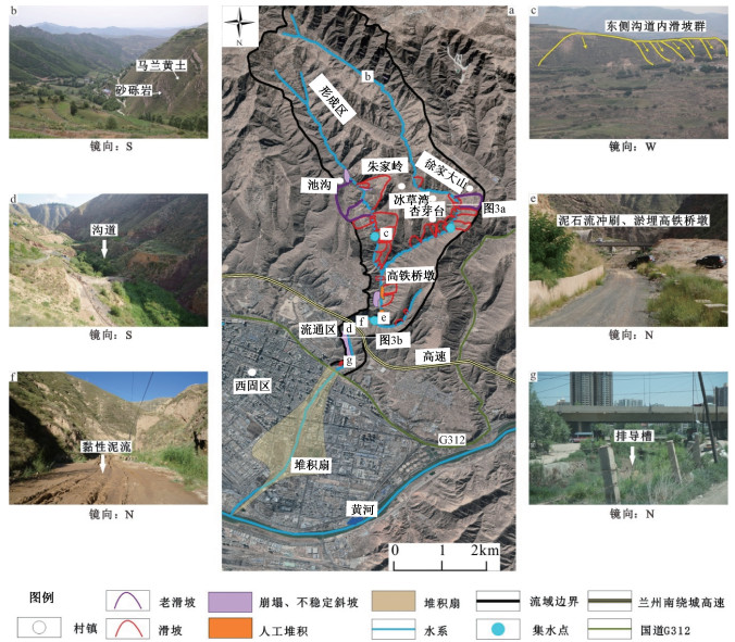
图 2 寺儿沟流域泥石流特征
a—寺儿沟泥石流遥感解译图;b—形成区沟谷形态及岸坡岩性;c—东支沟滑坡群;d—流通区沟道堆积及植被;e—兰西高铁横跨寺儿沟;f—流通区新发黏性泥石流堆积;g—沟口排导槽内植被生长茂盛
Figure 2. Characteristics of the debris flows in the Siergou watershed
(a) Remote sensing interpretation of the debris flows; (b) Gully morphology and bank slope lithology in the formation area; (c) Landslide group along the east sub-branch; (d) Trench accumulation and vegetation in the circulation area; (e) The Lanzhou-Xining high-speed railway spans the Siergou watershed; (f) New accumulation of viscous debris flows in the circulation area; (g) Vegetation flourish in the trench drain channel
图 4 寺儿沟流域物源类型及崩滑体分布
a—西固二号隧道危岩体;b—崩塌形成倒石锥;c—滑坡编号;d—流通区沟谷及沟道堆积;e—人为型物源
Figure 4. Source types and distribution of slumped masses in the Siergou watershed
(a) Unstable rock mass over the Xigu No.2 tunnel; (b) Rockfall cone formed by a collapse; (c) Landslide number; (d) Gullies and accumulations in the circulation area; (e) Anthropogenic sources
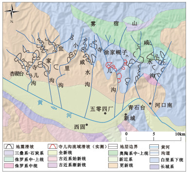
图 6 兰州南部山区地震滑坡分布图(据袁道阳等,2002修改)
Figure 6. Seismic landslide distribution map in the southern mountainous area of Lanzhou (modified from Yuan et al., 2002)
表 2 寺儿沟流域物源静储量统计
Table 2. Static reserves of material sources in the Siergou watershed
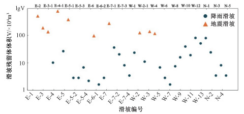
物源类型 各部分静储量 静储量/×104 m3 坡面侵蚀型 地层岩性 Q3黄土 Q3黄土 Q3黄土 K1砂砾岩 2908.31 可侵蚀深度/m 2 1.5 1 0.5 面积/×104 m2 234.09 1049.04 676.20 380.76 累计最大侵蚀量/×104 m3 468.17 1573.56 676.20 190.38 崩滑型 崩塌体静储量/×104 m3 114.00 3465.84 滑坡体静储量/×104 m3 3351.84 沟道型 沟道面积/m2 堆积厚度/m 静储量/×104 m3 10.97 形成区 32800 3 9.84 流通区 5670 2 1.13 人为型 16×104 m3 16.00 表 1 寺儿沟流域崩滑体物源静储量表(表中滑坡编号见图 4c)
Table 1. Static reserves of slumped masses in the Siergou watershed (corresponding landslide numbers are shown in Fig. 4c)
编号 灾害体规模
长×宽×高/m静储量/
×104 m3灾害体类型 编号 灾害体规模
长×宽×高/m静储量/
×104 m3灾害体类型 E-1 450×650×50 487.50 地震滑坡 W-2-1 65×230×20 9.97 降雨滑坡 E-2 360×370×45 199.80 地震滑坡 W-3 422×196×55 151.64 地震滑坡 E-3 400×250×45 150.00 地震滑坡 W-4 352×223×50 130.83 地震滑坡 E-3-1 72×200×30 14.40 降雨滑坡 W-5 65×200×15 6.50 降雨滑坡 E-4 750×640×45 720.00 地震滑坡 W-6 90×90×15 4.05 降雨滑坡 E-4-1 240×140×30 33.60 降雨滑坡 W-7 30×90×15 1.35 降雨滑坡 E-5 550×450×45 371.25 地震滑坡 W-8 120×110×20 8.80 降雨滑坡 E-5-1 59×70×30 4.13 降雨滑坡 W-9 150×170×25 21.25 降雨滑坡 E-5-2 50×96×30 4.80 降雨滑坡 W-10 250×230×25 47.92 降雨滑坡 E-5-3 69×140×30 9.66 降雨滑坡 W-11 200×150×25 25.00 降雨滑坡 E-5-4 40×97×30 3.88 降雨滑坡 W-12 300×230×40 92.00 降雨滑坡 E-6 300×360×30 108.00 地震滑坡 W-13 250×180×40 60.00 降雨滑坡 E-6-1 67×55×20 2.46 降雨滑坡 N-1 300×260×35 91.00 降雨滑坡 E-6-2 104×59×20 4.09 降雨滑坡 N-2 100×270×35 31.50 降雨滑坡 E-7 300×700×40 280.00 地震滑坡 N-3 67×80×30 5.36 降雨滑坡 E-7-1 200×270×25 45.00 降雨滑坡 N-4 60×190×30 11.40 降雨滑坡 E-7-2 120×270×25 27.00 降雨滑坡 N-5 150×70×15 5.25 降雨滑坡 E-7-3 117×114×25 11.12 降雨滑坡 西固二号隧道 100×830×10 83.00 危岩体 E-7-4 80×80×25 5.33 降雨滑坡 西固二号隧道 100×100×60 20.00 崩塌体 W-1 120×300×25 30.00 降雨滑坡 池沟 5×200×100 1.00 危岩体 W-2 400×170×60 136.00 地震滑坡 池沟 50×120×5 10.00 崩塌体 滑坡体总计 3351.84 崩塌危岩体总计 114.00 -
BERTOLO P, WIECZOREK G F, 2005. Calibration of numerical models for small debris flows in Yosemite Valley, California, USA[J]. Natural Hazards and Earth System Sciences, 5(6): 993-1001. doi: 10.5194/nhess-5-993-2005 DENG J L, 2018. Debris flow prediction model based on factor analysis method[J]. Gansu Water Resources and Hydropower Technology, 54(7): 26-30, 42. (in Chinese) DOMÈNECH G, FAN X M, SCARINGI G, et al., 2019. Modelling the role of material depletion, grain coarsening and revegetation in debris flow occurrences after the 2008 Wenchuan earthquake[J]. Engineering Geology, 250: 34-44. doi: 10.1016/j.enggeo.2019.01.010 DOU X D, 2020. Hazard evaluation and control scheme of Daqinggou debris flow disasters in Anning District of Lanzhou[J]. Resource Information and Engineering, 35(1): 110-112. (in Chinese with English abstract) FEI X J, SHU A P, 2004. Movement mechanism and disaster control for debris flow[M]. Beijing: Tsinghua University Press. (in Chinese) GUO X J, LI Y, CUI P, et al., 2020. Intermittent viscous debris flow formation in Jiangjia Gully from the perspectives of hydrological processes and material supply[J]. Journal of Hydrology, 589: 125184. doi: 10.1016/j.jhydrol.2020.125184 HU C H, ZHANG X M, 2020. Loess Plateau soil erosion governance and runoff-sediment variation of Yellow River[J]. Water Resources and Hydropower Engineering, 51(1): 1-11. (in Chinese with English abstract) HU S, QIU H J, WANG N L, et al., 2021. The influence of terrain on loess landslides in Loess Plateau[J]. Acta Geographica Sinica, 76(11): 2697-2709. (in Chinese with English abstract) doi: 10.11821/dlxb202111008 JIANG Z X, 1994. Aquantitative forecast to reserves change of solid loose materials in debris flow ravine[J]. Mountain Research, 12(3): 155-162. (in Chinese with English abstract) JIN L Y, 2004. Development characteristics and disaster assessment methods of debris flow in Loess region: a case study of debris flow disaster assessment in urban planning area of Dingxi City[J]. Gansu Science and Technology, 20(9): 20-24. (in Chinese) doi: 10.3969/j.issn.1000-0952.2004.09.009 KEEFER D K, 1984. Landslides caused by earthquakes[J]. GSA Bulletin, 95(4): 406-421. doi: 10.1130/0016-7606(1984)95<406:LCBE>2.0.CO;2 LI C A, 2004. The primary research of the forecast model of the source area's soil starting for the soil-mechanical debris flows[D]. Beijing: China Academy of Railway Sciences. (in Chinese with English abstract) LI H J, LIU Z, HE F, 2021. Landslide prediction based on grey theory and regression analysis[J]. Building Technology Development, 48(1): 149-151. (in Chinese with English abstract) LI W L, XU Q, HUANG R Q, 2013. A preliminary study on the back wave surface effect of Wenchuan earthquake landslide[J]. Acta Geologica Sinica, 87(S1): 294-295. (in Chinese) LI X Z, KONG J M, WANG C H, 2007. Comparison and application of grey GM (1, 1) modified residual error models in landslide predicting[J]. Journal of Mountain Science, 25(6): 741-746. (in Chinese with English abstract) doi: 10.3969/j.issn.1008-2786.2007.06.015 LIANG H X, SHANG M, XU X, 2016. Research on the influence factors of flow and deposition of debris flow based on the FLO-2D simulation[J]. Journal of Engineering Geology, 24(2): 228-234. (in Chinese with English abstract) LIN M L, WANG K L, HUANG J J, 2005. Debris flow run off simulation and verification-case study of Chen-You-Lan watershed, Taiwan[J]. Natural Hazards and Earth System Sciences, 5(3): 439-445. doi: 10.5194/nhess-5-439-2005 LIU X R, 2016. Hazard assessment of debris flows in Lanzhou City[J]. Northwestern Geology, 49(1): 257-262. (in Chinese with English abstract) doi: 10.3969/j.issn.1009-6248.2016.01.027 LIU Y L, GUAN H P, LI J L, 2001. Time-and-space distribution and prevention of debris flow in Lanzhou district[J]. Journal of Lanzhou Railway Institute, 20(1): 30-35. LU D F, WEI Y T, 2015. A brief analysis of the risk of mudslides in Guanshangou, Anning District, Lanzhou City[J]. Ground Water, 37(6): 195-197. (in Chinese) doi: 10.3969/j.issn.1004-1184.2015.06.083 MA C, HU K H, TIAN M, 2013. Post-earthquake relationships of maximum runout amount and loose matter mass in debris flow gully[J]. Journal of Natural Disasters, 22(6): 76-84. (in Chinese with English abstract) NIU Q F, LU M, LI Y F, et al., 2019. Hazard assessment of debris flow in Lanzhou City of Gansu Province based on methods of grey relation and rough dependence[J]. The Chinese Journal of Geological Hazard and Control, 30(5): 48-56. (in Chinese with English abstract) PAN H L, AN X, DENG Q J, et al., 2020. Progress and prospects of research on debris flow solid source[J]. Science Technology and Engineering, 20(24): 9733-9741. (in Chinese with English abstract) doi: 10.3969/j.issn.1671-1815.2020.24.007 PENG J B, LIN H C, WANG Q Y, et al., 2014. The critical issues and creative concepts in mitigation research of loess geological hazards[J]. Journal of Engineering Geology, 22(4): 684-691. (in Chinese with English abstract) PENG J B, WANG Q Y, ZHUANG J Q, et al., 2020. Dynamic formation mechanism of landslide disaster on the Loess Plateau[J]. Journal of Geomechanics, 26(5): 714-730. (in Chinese with English abstract) QIAO J P, HUANG D, YANG Z J, et al., 2012. Statistical method on dynamic reserve of debris flow's source materials in meizoseismal area of Wenchuan earthquake region[J]. The Chinese Journal of Geological Hazard and Control, 23(2): 1-6. (in Chinese with English abstract) doi: 10.3969/j.issn.1003-8035.2012.02.001 QIN Y L, WU J L, ZHAN H Y, et al., 2021. Discussion on the correlation between active fault and geological disaster distribution in the Ganzi area, western Sichuan province, China[J]. Journal of Geomechanics, 27(3): 463-474. (in Chinese with English abstract) SUN X C, WANG B Y, LIU K X, et al., 2020. Analysis on influencing factors of debris flow disasters in Yunnan Province[J]. Yangtze River, 51(11): 121-127. (in Chinese with English abstract) doi: 10.11988/ckyyb.20190825 TANG C, ZHOU J Q, ZHU J, et al., 1994. A study on the risk zoning of debris flow on alluvial fans by applying technology of numerical simulation[J]. Journal of Catastrophology, 9(4): 7-13. (in Chinese with English abstract) WANG W, 2007. Distribution and disaster characteristics of landslides and landslides in Lanzhou[J]. Scienfic & Technical Information of Gansu, 35(6): 56, 180. (in Chinese) WANG X A, CHEN J G, CHEN H Y, et al., 2020. Calculation of debris flow velocity in consideration of viscosity of slurry[J]. Journal of Yangtze River Scientific Research Institute, 37(4): 56-61. (in Chinese with English abstract) WANG Y Y, ZHAN Q D, HAN W L, et al., 2003. Stress-strain properties of viscous debris flow and determination of volocity parameter[J]. The Chinese Journal of Geological Hazard and Control, 14(1): 9-13. (in Chinese with English abstract) WU J H, ZHANG C S, YANG W M, et al., 2022. Risk assessment of debris flow in Zhujiagully watershed based on entropy weight coefficient of variation fusion algorithm and FLO-2D[J]. Journal of Natural Disasters, 31(1): 81-91. (in Chinese with English abstract) WU Y H, LIU K F, CHEN Y C, 2013. Comparison between FLO-2D and Debris-2D on the application of assessment of granular debris flow hazards with case study[J]. Journal of Mountain Science, 10(2): 293-304. doi: 10.1007/s11629-013-2511-1 YAN L Y, LI X B, OUYANG G L, 2021. Research progress in formation mechanism of loess coseismic landslides[J]. Journal of Institute of Disaster Prevention, 23(2): 46-53. (in Chinese with English abstract) YANG J, 2015. Discussion on soil and water loss control model in Loess Plateau of Gansu Province[J]. Soil and Water Conservation in China(4): 33-35. (in Chinese) YANG S, 2014. Study on the movable critical model of solid materials under hydro-dynamical condition in debris flow area[D]. Chengdu: University of Chinese Academy of Sciences. (in Chinese with English abstract) YU B, TANG C, 2016. Dynamic characteristics and activity law of debris flow[M]. Beijing: Science Press. (in Chinese) YUAN D Y, LEI Z S, LIU B C, et al., 2002. Textual research on the 1125 Lanzhou M7.0 earthquake and the causative structure[J]. Earthquake Research in China, 18(1): 67-75. (in Chinese with English abstract) ZHANG D, WU Z H, LI J C, et al., 2013. An overview on earthquake-induced landslide research[J]. Journal of Geomechanics, 19(3): 225-241. (in Chinese with English abstract) ZHANG H W, LIU F Z, WANG J C, et al., 2022. Hazard assessment of debris flows in Kongpo Gyamda, Tibet based on FLO-2D numerical simulation[J]. Journal of Geomechanics, 28(2): 306-318. (in Chinese with English abstract) ZHANG J K, 1994. Summary on debris flow research[J]. The Chinese Journal of Geological Hazard and Control, 5(4): 1-8. (in Chinese with English abstract) 邓玖林, 2018. 基于因子分析法的泥石流预测模型[J]. 甘肃水利水电技术, 54(7): 26-30, 42. https://www.cnki.com.cn/Article/CJFDTOTAL-GSSJ201807008.htm 窦晓东, 2020. 兰州市安宁区大青沟泥石流灾害危害性评价及治理方案[J]. 资源信息与工程, 35(1): 110-112. https://www.cnki.com.cn/Article/CJFDTOTAL-YSJW202001030.htm 费祥俊, 舒安平, 2004. 泥石流运动机理与灾害防治[M]. 北京: 清华大学出版社. 胡春宏, 张晓明, 2020. 黄土高原水土流失治理与黄河水沙变化[J]. 水利水电技术, 51(1): 1-11. https://www.cnki.com.cn/Article/CJFDTOTAL-SJWJ202001001.htm 胡胜, 邱海军, 王宁练, 等, 2021. 地形对黄土高原滑坡的影响[J]. 地理学报, 76(11): 2697-2709. https://www.cnki.com.cn/Article/CJFDTOTAL-DLXB202111009.htm 蒋忠信, 1994. 泥石流固体物质储量变化的定量预测[J]. 山地研究, 12(3): 155-162. https://www.cnki.com.cn/Article/CJFDTOTAL-SDYA403.004.htm 金凌燕, 2004. 黄土地区泥石流发育特点及灾害评估方法: 以定西市城市规划区泥石流灾害评估为例[J]. 甘肃科技, 20(9): 20-24. https://www.cnki.com.cn/Article/CJFDTOTAL-GSKJ200409008.htm 李朝安, 2004. 土力类泥石流源地土体起动预报模型初步研究[D]. 北京: 铁道部科学研究院. 栗海军, 刘泽, 何矾, 2021. 基于灰色理论和非线性回归分析的滑坡时间组合预测研究[J]. 建筑技术开发, 48(1): 149-151. https://www.cnki.com.cn/Article/CJFDTOTAL-JZKF202101079.htm 李为乐, 许强, 黄润秋, 2013. 汶川地震滑坡背波面效应初探[J]. 地质学报, 87(S1): 294-295. https://www.cnki.com.cn/Article/CJFDTOTAL-DZXE2013S1138.htm 李秀珍, 孔纪名, 王成华, 2007. 灰色GM(1, 1)残差修正模型在滑坡预测中的对比应用[J]. 山地学报, 25(6): 741-746. https://www.cnki.com.cn/Article/CJFDTOTAL-SDYA200706015.htm 梁鸿熙, 尚敏, 徐鑫, 2016. 基于FLO-2D数值模拟的泥石流流动与堆积影响因素研究[J]. 工程地质学报, 24(2): 228-234. https://www.cnki.com.cn/Article/CJFDTOTAL-GCDZ201602010.htm 刘兴荣, 2016. 兰州市城区泥石流危险性评价[J]. 西北地质, 49(1): 257-262. https://www.cnki.com.cn/Article/CJFDTOTAL-XBDI201601030.htm 鲁得方, 魏玉涛, 2015. 浅析兰州市安宁区关山沟泥石流风险性[J]. 地下水, 37(6): 195-197. 马超, 胡凯衡, 田密, 2013. 震后泥石流沟松散物质量与最大冲出总量的关系[J]. 自然灾害学报, 22(6): 76-84. https://www.cnki.com.cn/Article/CJFDTOTAL-ZRZH201306011.htm 牛全福, 陆铭, 李月锋, 等, 2019. 基于灰色关联与粗糙依赖度的甘肃兰州市区泥石流危险性评价[J]. 中国地质灾害与防治学报, 30(5): 48-56. https://www.cnki.com.cn/Article/CJFDTOTAL-ZGDH201905007.htm 潘华利, 安笑, 邓其娟, 等, 2020. 泥石流松散固体物源研究进展与展望[J]. 科学技术与工程, 20(24): 9733-9741. https://www.cnki.com.cn/Article/CJFDTOTAL-KXJS202024007.htm 彭建兵, 林鸿州, 王启耀, 等, 2014. 黄土地质灾害研究中的关键问题与创新思路[J]. 工程地质学报, 22(4): 684-691. https://www.cnki.com.cn/Article/CJFDTOTAL-GCDZ201404018.htm 彭建兵, 王启耀, 庄建琦, 等, 2020. 黄土高原滑坡灾害形成动力学机制[J]. 地质力学学报, 26(5): 714-730. doi: 10.12090/j.issn.1006-6616.2020.26.05.059 乔建平, 黄栋, 杨宗佶, 等, 2012. 汶川地震极震区泥石流物源动储量统计方法讨论[J]. 中国地质灾害与防治学报, 23(2): 1-6. https://www.cnki.com.cn/Article/CJFDTOTAL-ZGDH201202003.htm 秦宇龙, 吴建亮, 詹涵钰, 等, 2021. 川西甘孜地区活动断裂与地质灾害分布相关性探讨[J]. 地质力学学报, 27(3): 463-474. doi: 10.12090/j.issn.1006-6616.2021.27.03.042 孙显辰, 王保云, 刘坤香, 等, 2020. 云南省泥石流灾害影响因子分析[J]. 人民长江, 51(11): 121-127. https://www.cnki.com.cn/Article/CJFDTOTAL-RIVE202011021.htm 唐川, 周钜乾, 朱静, 等, 1994. 泥石流堆积扇危险度分区评价的数值模拟研究[J]. 灾害学, 9(4): 7-13. https://www.cnki.com.cn/Article/CJFDTOTAL-ZHXU404.001.htm 王伟, 2007. 兰州地区滑坡泥石流分布及灾害特征[J]. 甘肃科技纵横, 35(6): 56, 180. https://www.cnki.com.cn/Article/CJFDTOTAL-LZKQ200706046.htm 王喜安, 陈剑刚, 陈华勇, 等, 2020. 考虑浆体黏度的泥石流流速计算方法[J]. 长江科学院院报, 37(4): 56-61. https://www.cnki.com.cn/Article/CJFDTOTAL-CJKB202004010.htm 王裕宜, 詹钱登, 韩文亮, 等, 2003. 粘性泥石流体的应力应变特性和流速参数的确定[J]. 中国地质灾害与防治学报, 14(1): 9-13. https://www.cnki.com.cn/Article/CJFDTOTAL-ZGDH200301002.htm 吴季寰, 张春山, 杨为民, 等, 2022. 基于熵权变异系数融合算法和FLO-2D的朱家沟流域泥石流危险性评价[J]. 自然灾害学报, 31(1): 81-91. https://www.cnki.com.cn/Article/CJFDTOTAL-ZRZH202201008.htm 颜灵勇, 李孝波, 欧阳刚垒, 2021. 黄土地震滑坡形成机理研究的若干进展[J]. 防灾科技学院学报, 23(2): 46-53. https://www.cnki.com.cn/Article/CJFDTOTAL-FZJS202102006.htm 杨俊, 2015. 甘肃省黄土高原地区水土流失治理模式探讨[J]. 中国水土保持(4): 33-35. https://www.cnki.com.cn/Article/CJFDTOTAL-ZGSB201504015.htm 杨顺, 2014. 水动力作用下泥石流源区固体物质可移动判别模型研究[D]. 成都: 中国科学院大学. 余斌, 唐川, 2016. 泥石流动力特性与活动规律研究[M]. 北京: 科学出版社. 袁道阳, 雷中生, 刘百篪, 等, 2002. 兰州1125年7级地震考证与发震构造分析[J]. 中国地震, 18(1): 67-75. https://www.cnki.com.cn/Article/CJFDTOTAL-ZGZD200201006.htm 张铎, 吴中海, 李家存, 等, 2013. 国内外地震滑坡研究综述[J]. 地质力学学报, 19(3): 225-241. https://journal.geomech.ac.cn/article/id/59c5f311-5f2f-467d-adfe-69e7da4f5fc6 张浩韦, 刘福臻, 王军朝, 等, 2022. 基于FLO-2D数值模拟的工布江达县城泥石流灾害危险性评价[J]. 地质力学学报, 28(2): 306-318. doi: 10.12090/j.issn.1006-6616.2021117 张杰坤, 1994. 泥石流研究综述[J]. 中国地质灾害与防治学报, 5(4): 1-8. https://www.cnki.com.cn/Article/CJFDTOTAL-ZGDH199404000.htm -


 下载:
下载:
