| Citation: | LIU Shuai,
HE Bin,
WANG Tao,
et al.,
2024. Development characteristics and susceptibility assessment of coseismic geological hazards of Jishishan MS 6.2 earthquake, Gansu Province, China. Journal of Geomechanics, 30 (2): 314-331. DOI: 10.12090/j.issn.1006-6616.2024009

|

|
ABBAS F, ZHANG F, ISMAIL M, et al., 2023. Optimizing machine learning algorithms for landslide susceptibility mapping along the Karakoram highway, Gilgit Baltistan, Pakistan: a comparative study of baseline, Bayesian, and metaheuristic Hyperparameter optimization techniques[J]. Sensors, 23(15): 6843. doi: 10.3390/s23156843
|
|
ACHU A L, AJU C D, DI NAPOLI M, et al., 2023. Machine-learning based landslide susceptibility modelling with emphasis on uncertainty analysis[J]. Geoscience Frontiers, 14(6): 101657. doi: 10.1016/j.gsf.2023.101657
|
|
ADO M, AMITAB K, MAJI A K, et al., 2022. Landslide susceptibility mapping using machine learning: a literature survey[J]. Remote Sensing, 14(13): 3029. doi: 10.3390/rs14133029
|
|
CANTARINO I, CARRION M A, GOERLICH F, et al., 2019. A ROC analysis-based classification method for landslide susceptibility maps[J]. Landslides, 16(2): 265-282. doi: 10.1007/s10346-018-1063-4
|
|
CHEN B, SONG C, CHEN Y, et al., 2024. Emergency Identification and Influencing Factor Analysis of Coseismic Landslides and Building Damages Induced by the 2023 MS6.2 Jishishan (Gansu, China) Earthquake[J/OL]. Geomatics and Information Science of Wuhan University, 1-16.
|
|
Danika S, Edward M, Sylvia H M, 2019. A Mixed-Methods Evaluation of a Gender Affirmative Education Program for Families of Trans Young People[J]. Journal of GLBT Family Studies, 16(1).
|
|
DE OLIVEIRA G G, RUIZ L F C, GUASSELLI L A, et al., 2019. Random forest and artificial neural networks in landslide susceptibility modeling: a case study of the Fão River Basin, Southern Brazil[J]. Natural Hazards, 99(2): 1049-1073. doi: 10.1007/s11069-019-03795-x
|
|
FAN W, WEI X S, CAO Y B, et al., 2017. Landslide susceptibility assessment using the certainty factor and analytic hierarchy process[J]. Journal of Mountain Science, 14(5): 906-925. doi: 10.1007/s11629-016-4068-2
|
|
FANG L H, YANG T, FAN L P, 2023. On December 18, 2023, Jishishan County, Linxia Prefecture, Gansu Province, MS 6.2 earthquake science and technology support briefing[EB/OL]. Geophysical Research Institute of China Seismological Bureau.
|
|
HUANG R Q, LI W L, 2008. Research on development and distribution rules of Geohazards induced by Wenchuan earthquake on 12th May, 2008[J]. Chinese Journal of Rock Mechanics and Engineering, 27(12): 2585-2592. (in Chinese with English abstract) doi: 10.3321/j.issn:1000-6915.2008.12.028
|
|
HUANG R Q, LI W L, 2008. "5.12" Wenchuan earthquake triggered the development and distribution of geological disasters [J]. Rock mechanics and engineering, 27 (12): 2585-2592. (in Chinese) doi: 10.3321/j.issn:1000-6915.2008.12.028
|
|
LI R, HUANG S Y, DOU H Q, 2023. Dynamic risk assessment of landslide hazard for large-scale photovoltaic power plants under extreme rainfall conditions[J]. Water, 15(15): 2832. doi: 10.3390/w15152832
|
|
LI W L, XU Q, LI Y S, et al., 2024. Preliminary analysis of the coseismic geohazards induced by the 2023 Jishishan MS6.2 earthquake[J]. Journal of Chengdu University of Technology (Science & Technology Edition), 51(1): 33-45, 90. (in Chinese with English abstract)
|
|
LI X, XUE G C, LIU C Z, et al., 2022. Evaluation of Geohazard susceptibility based on information value model and information value-logistic regression model: A case study of the central mountainous area of Hainan Island[J]. Journal of Geomechanics, 28(2): 294-305. (in Chinese with English abstract)
|
|
LIU J M, WANG T, DU J J, et al., 2023. Emergency rapid assessment of landslides induced by the Luding MS6.8 earthquake in Sichuan of China[J]. Hydrogeology & Engineering Geology, 50(2): 84-94. (in Chinese with English abstract)
|
|
LIU S, ZHU J Y, YANG D H, et al., 2023. Geological hazard assessment of collapse and landslide under different rainfall conditions[J/OL]. Bulletin of Geological Science and Technology, 1-19.
|
|
SHAREK D, MCCANN E, HUNTLEY-MOORE S, 2020. A mixed-methods evaluation of a gender affirmative education program for families of trans young people[J]. Journal of GLBT Family Studies, 16(1): 18-31. doi: 10.1080/1550428X.2019.1614504
|
|
SUN D L, CHEN D L, MI C L, et al., 2023. Evaluation of landslide susceptibility in the gentle hill-valley areas based on the interpretable random forest-recursive feature elimination model[J]. Journal of Geomechanics, 29(2): 202-219. (in Chinese with English abstract)
|
|
TIE Y B, ZHANG X Z, CAO J W, et al., 2024. Comparative research of the characteristics of geological hazards induced by the Jishishan (MS6.2) and Luding (MS6.8) earthquakes[J]. Journal of Chengdu University of Technology (Science & Technology Edition), 51(1): 9-21, 59. (in Chinese with English abstract)
|
|
WANG L C, HOU S S, DONG Y, et al., 2023. Basic characteristics of co-seismic geological hazards induced by Jishishan MS6.2 earthquake and suggestions for their risk control[J/OL]. The Chinese Journal of Geological Hazard and Control, 1-11.
|
|
WANG T, MA Y S, LONG C X, et al., 2008. Fault activity of the Wenchuan earthquake in Sichuan, China and seismic secondary geohazards[J]. Geological Bulletin of China, 27(11): 1913-1922. (in Chinese with English abstract)
|
|
WANG T, WU S R, SHI J S, et al., 2015. Concepts and mechanical assessment method for seismic landslide hazard: a review[J]. Journal of Engineering Geology, 23(1): 93-104. (in Chinese with English abstract)
|
|
WANG Y S, ZHAO B, JI F, et al., 2024. Preliminary insights into the hazards triggered by the 2023 Jishishan MS6.2 earthquake in Gansu province[J]. Journal of Chengdu University of Technology (Science & Technology Edition), 51(1): 1-8. (in Chinese with English abstract)
|
|
XIAO L, 2012. Study on the attenuation relationship of strong ground motion parameters of horizontal bedrock [J]. International seismic dynamics, (1): 37-39. (in Chinese with English abstract)
|
|
XU C, XU X W, 2012. GIS and ANN model for earthquake triggered landslides susceptibility zonation[J]. Geological Science and Technology Information, 31(3): 116-121. (in Chinese with English abstract
|
|
XU Q, HUANG R Q, 2008. Kinetics charateristics of large landlides triggered by May 12th Wenchuan earthquake[J]. Journal of Engineering Geology, 16(6): 721-729. (in Chinese with English abstract)
|
|
YANG Z H, LAN H X, ZHANG Y S, et al., 2017. Research review on long-term activity of post-earthquake geohazard in strong seismic-disturbed regions[J]. Journal of Geomechanics, 23(5): 743-753. (in Chinese with English abstract)
|
|
YIN Y P, ZHANG Y S, WU F Q, et al., 2014. Research achievements and prospects on Wenchuan earthquake-induced Geohazard investigation[J]. Geological Survey of China, 1(1): 1-9. (in Chinese with English abstract)
|
|
YOUSSEF A M, POURGHASEMI H R, POURTAGHI Z S, et al., 2016. Landslide susceptibility mapping using random forest, boosted regression tree, classification and regression tree, and general linear models and comparison of their performance at Wadi Tayyah Basin, Asir Region, Saudi Arabia[J]. Landslides, 13(5): 839-856.
|
|
YUAN D Y, 2003. Tectonic deformation features and space-time evolution in northeastern margin of the Qinghai-Tibetan Plateau since the late Cenozoic time[D]. Beijing: Institute of Geology, China Earthquake Administration. (in Chinese with English abstract)
|
|
YUAN D Y, ZHANG P Z, LEI Z S, et al., 2005. A preliminary study on the new activity features of the Lajishan mountain fault zone in Qinghai Province[J]. Earthquake Research in China, 21(1): 93-102. (in Chinese with English abstract)
|
|
ZANG B, 2012. The study of new activities on western segment of northern margin of western Qinling fault and Laji Shan fault[D]. Lanzhou: Lanzhou Institute of Seismology, China Earthquake Administration. (in Chinese with English abstract)
|
|
ZHANG Y S, MA Y S, HU D G, et al., 2010. Investigation and research on the surface rupture of the Yushu earthquake and reconstruction site selection[J]. Acta Geologica Sinica, 84(5): 593-605. (in Chinese with English abstract)
|
|
陈博, 宋闯, 陈毅, 等, 2024. 2023年甘肃积石山MS6.2地震同震滑坡和建筑物损毁情况应急识别与影响因素研究[J/OL]. 武汉大学学报(信息科学版), 1-16.
|
|
房立华, 杨婷, 范莉苹, 2023. 2023年12月18日甘肃临夏州积石山县6.2级地震科技支撑简报[EB/OL]. 中国地震局地球物理研究所.
|
|
黄润秋, 李为乐, 2008. "5.12"汶川大地震触发地质灾害的发育分布规律研究[J]. 岩石力学与工程学报, 27(12): 2585-2592. https://www.cnki.com.cn/Article/CJFDTOTAL-YSLX200812032.htm
|
|
李为乐, 许强, 李雨森, 等, 2024. 2023年积石山MS6.2级地震同震地质灾害初步分析[J]. 成都理工大学学报(自然科学版), 51(1): 33-45, 90. https://www.cnki.com.cn/Article/CJFDTOTAL-CDLG202401004.htm
|
|
李信, 薛桂澄, 柳长柱, 等, 2022. 基于信息量模型和信息量-逻辑回归模型的海南岛中部山区地质灾害易发性研究[J]. 地质力学学报, 28(2): 294-305. doi: 10.12090/j.issn.1006-6616.2021111?viewType=HTML
|
|
刘甲美, 王涛, 杜建军, 等, 2023. 四川泸定MS6.8级地震诱发崩滑灾害快速评估[J]. 水文地质工程地质, 50(2): 84-94. https://www.cnki.com.cn/Article/CJFDTOTAL-SWDG202302009.htm
|
|
刘帅, 朱杰勇, 杨得虎, 等, 2023. 不同降雨工况条件下的崩滑地质灾害危险性评价[J/OL]. 地质科技通报, 1-19.
|
|
孙德亮, 陈丹璐, 密长林, 等, 2023. 基于随机森林-特征递归消除模型的可解释性缓丘岭谷地貌滑坡易发性评价[J]. 地质力学学报, 29(2): 202-219. doi: 10.12090/j.issn.1006-6616.2022128?viewType=HTML
|
|
铁永波, 张宪政, 曹佳文, 等, 2024. 积石山MS6.2级和泸定MS6.8级地震地质灾害发育规律对比[J]. 成都理工大学学报(自然科学版), 51(1): 9-21, 59. https://www.cnki.com.cn/Article/CJFDTOTAL-CDLG202401002.htm
|
|
王立朝, 侯圣山, 董英, 等, 2023. 甘肃积石山MS6.2级地震的同震地质灾害基本特征及风险防控建议[J/OL]. 中国地质灾害与防治学报, 1-11.
|
|
王涛, 马寅生, 龙长兴, 等, 2008. 四川汶川地震断裂活动和次生地质灾害浅析[J]. 地质通报, 27(11): 1913-1922. https://www.cnki.com.cn/Article/CJFDTOTAL-ZQYD200811025.htm
|
|
王涛, 吴树仁, 石菊松, 等, 2015. 地震滑坡危险性概念和基于力学模型的评估方法探讨[J]. 工程地质学报, 23(1): 93-104. https://www.cnki.com.cn/Article/CJFDTOTAL-GCDZ201501019.htm
|
|
王运生, 赵波, 吉锋, 等, 2024. 2023年甘肃积石山MS6.2级地震震害异常的启示[J]. 成都理工大学学报(自然科学版), 51(1): 1-8. https://www.cnki.com.cn/Article/CJFDTOTAL-CDLG202401001.htm
|
|
肖亮, 2012. 水平向基岩强地面运动参数衰减关系研究[J]. 国际地震动态, (1): 37-39. https://www.cnki.com.cn/Article/CJFDTOTAL-GJZT201201016.htm
|
|
许冲, 徐锡伟, 2012. 基于GIS与ANN模型的地震滑坡易发性区划[J]. 地质科技情报, 31(3): 116-121. https://www.cnki.com.cn/Article/CJFDTOTAL-DZKQ201203019.htm
|
|
许强, 黄润秋, 2008. 5.12汶川大地震诱发大型崩滑灾害动力特征初探[J]. 工程地质学报, 16(6): 721-729. https://www.cnki.com.cn/Article/CJFDTOTAL-GCDZ200806001.htm
|
|
杨志华, 兰恒星, 张永双, 等, 2017. 强震区震后地质灾害长期活动性研究综述[J]. 地质力学学报, 23(5): 743-753. https://journal.geomech.ac.cn/article/id/416fc018-d66f-480e-b56e-55765e72d737?viewType=HTML
|
|
殷跃平, 张永双, 伍法权, 等, 2014. 汶川地震地质灾害调查成果与展望[J]. 中国地质调查, 1(1): 1-9. https://www.cnki.com.cn/Article/CJFDTOTAL-DZDC201401002.htm
|
|
袁道阳, 2003. 青藏高原东北缘晚新生代以来的构造变形特征与时空演化[D]. 北京: 中国地震局地质研究所.
|
|
袁道阳, 张培震, 雷中生, 等, 2005. 青海拉脊山断裂带新活动特征的初步研究[J]. 中国地震, 21(1): 93-102. https://www.cnki.com.cn/Article/CJFDTOTAL-ZGZD200501009.htm
|
|
张波, 2012. 西秦岭北缘断裂西段与拉脊山断裂新活动特征研究[D]. 兰州: 中国地震局兰州地震研究所.
|
|
张永双, 马寅生, 胡道功, 等, 2010. 玉树地震地表破裂调查与灾后重建避让选址研究[J]. 地质学报, 84(5): 593-605. https://www.cnki.com.cn/Article/CJFDTOTAL-DZXE201005002.htm
|
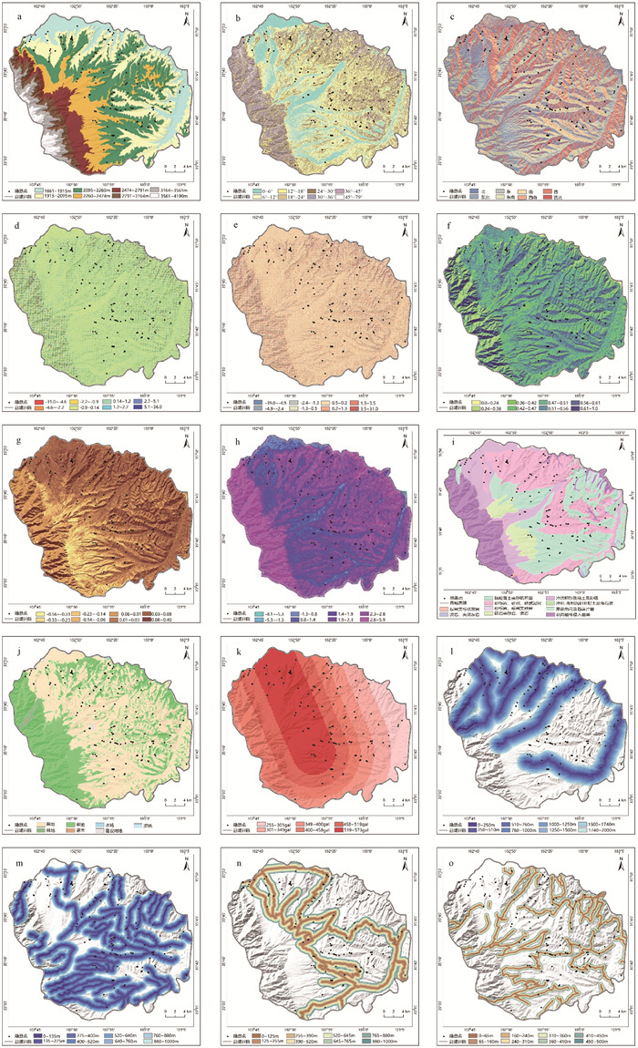
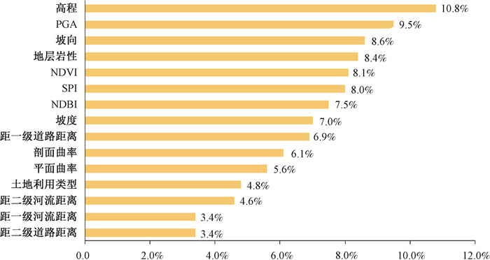
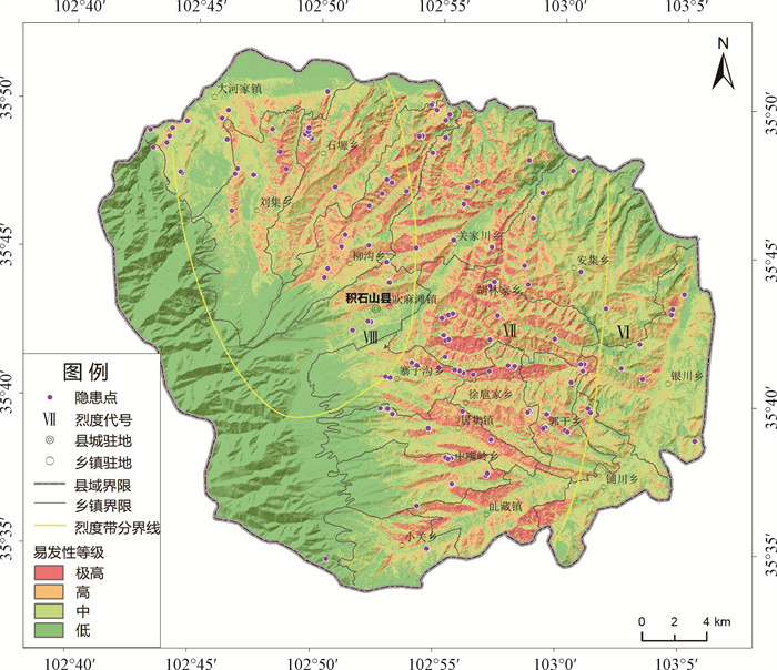
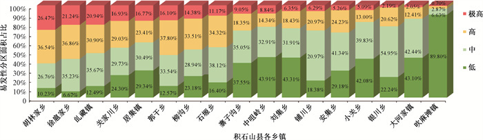
Figures(16) / Tables(1)
Website Copyright © Journal of Geomechanics 京ICP备18031784号 Total visits:
Supported by:
Beijing Renhe Information Technology Co., Ltd.


 DownLoad: