

SEISMOGENIC STRUCTURE OF THE Ms7.0 EARTHQUAKE ON AUGUST 8, 2017 IN JIUZHAIGOU, SICHUAN
-
摘要: 2017年8月8日21时19分,四川阿坝州九寨沟县发生7.0级地震,震中位于巴颜喀拉块体东边界虎牙断裂和东昆仑断裂带东段塔藏断裂交汇区域,地震构造背景较为复杂。地震导致了房屋和道路破坏、滑坡崩塌。根据高分辨率卫星影像解译、阶地坎变形的测量和测年数据得到:塔藏断裂东段晚第四纪以来以左旋走滑为主,兼逆分量,水平滑动速率为2.7~4.1 mm/yr,垂直滑动速率为0.56~0.6 mm/yr。结合此次地震的主余震分布、主震震源机制解等综合结果,初步建立了三维发震构造模型,分析认为此次地震属于走滑型地震,主破裂倾角57°~77°,发震断层可能是塔藏断裂的一条分支,是青藏高原块体向东推挤的一次地震事件。基于历史地震、活动断裂和形变观测方面的研究,巴颜喀拉块体具备显著的强震构造背景,对于该块体边界带周缘的强震活动和变形需要继续关注。
-
关键词:
- 九寨沟Ms7.0级地震 /
- 塔藏断裂东段 /
- 活动断裂 /
- 发震构造 /
- 巴颜喀拉块体
Abstract: An Ms7.0 earthquake struck Jiuzhaigou county at 9:19 pm on August 8, 2017 in Aba Prefecture of Sichuan Province. The epicenter was located in the intersection area of the Huya fault on the east boundary of the Bayan Har block and the Tazang fault on the east section of the East Kunlun fault, with complicated seismotectonic settings. This earthquake caused damages to houses and roads, and landslides collapsed. According to the data of high-resolution satellite image interpretation, the measurement data of tectonic deformation and dating data, it shows that the east section of the Tazang fault has been dominated by left-lateral strike-slip accompanied with thrust faulting; the horizontal sliding rate is about 2.7~4.1 mm/yr, and the vertical sliding rate is about 0.56~0.6 mm/yr. Combined with the distribution of major earthquake and aftershocks and the results of major earthquake source mechanism solution, a three-dimensional seismic structure model is established. The analysis reveals that this earthquake belongs to strike-slip earthquake with the main rupture angle of 57°~77°. It was caused by the eastward push of the Qinghai-Tibet Plateau mass, and the seismogenic fault may be a branch of the Tazang fault. According to the study of historical earthquakes, active faults and deformation observation, the Bayan Kala block has significant strong earthquake tectonic background, and it is necessary to continue to pay attention to the seismic activity and deformation of the boundary of the block. -

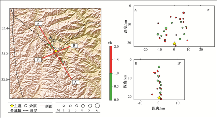
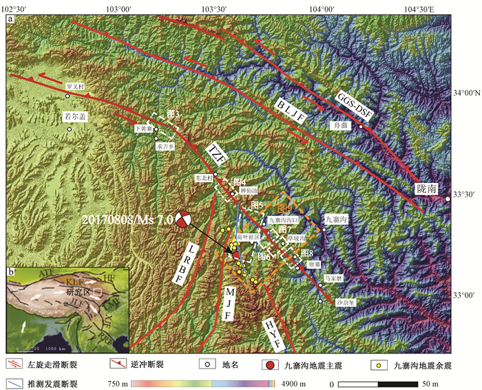
图 1 研究区断裂及余震分布图
ATF—阿尔金断裂带;HF—海原断裂带;KTF—昆仑断裂带;LMF—龙门山断裂带;JLF—嘉黎断裂带;RRF—红河断裂带;TZF—塔藏断裂;LRBF—龙日坝断裂;MJF—岷江断裂;BLGF—白龙江断裂;GGS-DSF—光盖山-迭山断裂;HYF—虎牙断裂
Figure 1. Distribution map of regional faults and aftershocks in the study area

图 2 地震精定位及余震分布图(据IGP-CEA)
Figure 2. Precise location of the earthquake and distribution map of aftershocks

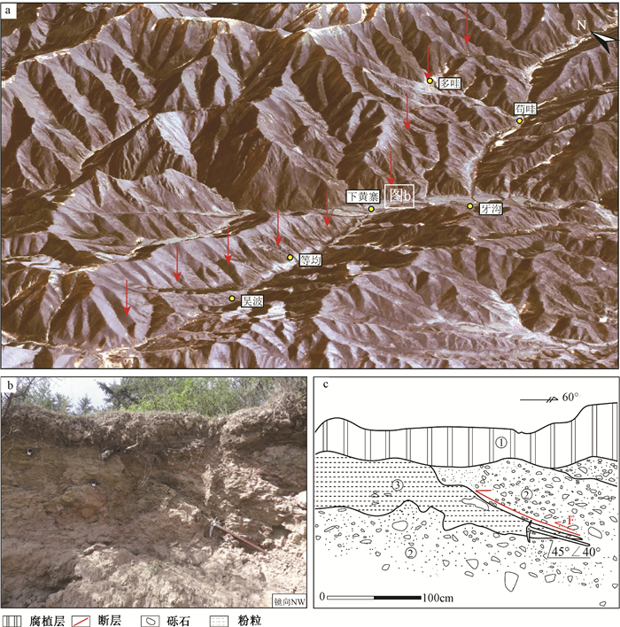
图 3 下黄寨遥感解译及断层剖面
a-高分一号影像三维可视化解译(图中箭头指示断层位置);b-断层剖面;c-断层剖面示意图
Figure 3. GF-1 remote sensing image and fault profile of Xiahuangzhai

图 4 神仙池附近遥感解译及断错地貌
a-神仙池附近高分一号影像三维可视化;b-断错地貌照片;c-地层褶皱照片
Figure 4. GF-1 remote sensing image and fault profile of Shenxianchi area

图 5 漳扎镇附近遥感解译
a-漳扎镇一带高分一号三维可视化;b-彭布地貌照片;c-荷叶地貌照片;d-彭布断层剖面
Figure 5. GF-1 remote sensing image and landform near Zhangzha Town

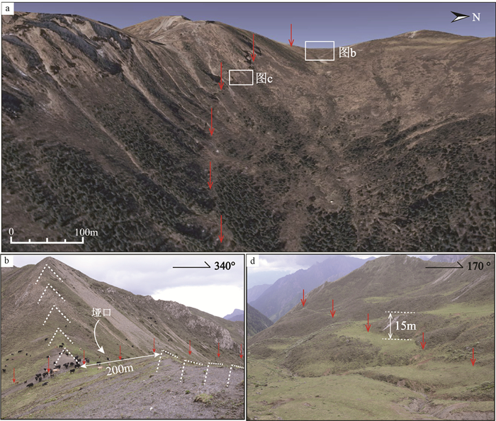
图 6 草坡沟西北断错地貌
a-Google earth影像;b-山脊位错;c-断层陡坎
Figure 6. Dislocation landform in northwestern Caopogou

图 7 若也得附近冲洪积的断错
a-Google earth影像;b-高分一号影像;c-地貌位错图;d-T2阶断层陡坎地实测剖面;e-采样剖面洪积扇位错
Figure 7. Dislocation of alluvial fan near Ruoyedei area

图 8 唐寨无人机航拍与DGPS测量
a-唐寨断错地貌;b-无人机航拍图;c-DGPS实测地形;d-T2阶断层陡坎地实测剖面;e-T3阶地断层陡坎实测剖面;g、f-采样剖面图
Figure 8. UAV aerial image and DGPS measurement of Tangzhai
表 1 四川九寨沟7.0级地震的震源机制解参数
Table 1. Focal mechanism solutions of the Jiuzhaigou Ms7.0 earthquake
资料来源 断层节面Ⅰ 断层节面Ⅱ 震中 震源深度
/km震级 走向/° 倾角/° 滑动角/° 走向/° 倾角/° 滑动角/° CENC 326 62 15 64 77 151 103.82°E 33.20°N 20 M7.0 Global-CMT 150 78 13 242 77 150 103.90°E 33.21°N 14.9 Ms6.5 IGP-CEA 153 84 33 246 57 173 103.85°E 33.19°N 13.5 Mw6.5  下载: 导出CSV
表 2 AMS 14C样品测年结果
Table 2. The dating reults of AMS14C samples
样品编号 实验室样品编号 采样深度/m 13C/12C 样品岩性 年龄结果/a BP JZG-C-01 440594 1.8 25.4% 碳屑 2450±30 JZG-C-02 446948 1.2 24.9% 碳屑 5110±30 JZG-C-03 440593 1.0 26.9% 碳屑 1470±30 注:样品由美国BETA实验室测试
下载: 导出CSV
-
[1] Tapponnier P, Zhiqin X, Roger F, et al. Oblique stepwise rise and growth of the Tibet plateau[J]. Science, 2001, 294(5547):1671. doi: 10.1126/science.105978 [2] Zhang P Z, Shen Z, Wang M, et al. Continuous deformation of the Tibetan Plateau from global positioning system data[J]. Geology, 2004, 32(9):809~812. doi: 10.1130/G20554.1 [3] Beaumont C, Jamieson R A, Nguyen M H, et al. Himalayan tectonics explained by extrusion of a low-viscosity crustal channel coupled to focused surface denudation[J]. Nature, 2001, 414(6865):738. doi: 10.1038/414738a [4] Wang Q, Zhang PZ, Freymueller JT, et al. Present-day crustal deformation in China constrained by global positioning system measurements[J]. Science, 2001, 294(5542):574. doi: 10.1126/science.1063647 [5] 马杏垣.中国岩石圈动力学地图集[M].北京:中国地图出版社, 1989. 16.MA Xingyuan. Lithospheric Dynamics Atlas of China[M]. Beijing:SinoMaps Press, 1989. 16. (in Chinese) [6] 周荣军, 蒲晓虹, 何玉林, 等.四川岷江断裂带北段的新活动、岷山断块的隆起及其与地震活动的关系[J].地震地质, 2000, 22(3):285~294. http://d.wanfangdata.com.cn/Periodical/dzdz200003009ZHOU Rongjun, PU Xiaohong, HE Yulin, et al. Recent activity of Minjiang fault zone, uplift of Minshan block and their relationship with seimicacity of Sichuan[J]. Seismology and Geology, 2000, 22(3):285~294. (in Chinese with English abstract) http://d.wanfangdata.com.cn/Periodical/dzdz200003009 [7] 唐文清, 刘宇平, 陈智梁, 等.岷山隆起边界断裂构造活动初步研究[J].沉积与特提斯地质, 2004, 24(4):31~34. http://d.wanfangdata.com.cn/Periodical/yxgdl200404004TANG Wenqing, LIU Yuping, CHEN Zhiliang, et al. The preliminary study of the tectonic activities along the boundary faults around the Minshan uplift, western Sichuan[J]. Sedimentary Geology and Tethyan Geology, 2004, 24(4):31~34. (in Chinese with English abstract) http://d.wanfangdata.com.cn/Periodical/yxgdl200404004 [8] 周荣军, 李勇, Densmore A L, 等.青藏高原东缘活动构造[J].矿物岩石, 2006, 26(2):40~51. http://d.wanfangdata.com.cn/Periodical/kwys200602007ZHOU Rongjun, LI Yong, Densmore A L, et al. Active tectonic of the eastern margin of the Tibet plateau[J]. Journal of Mineralogy and Petrology, 26(2):40~51. (in Chinese with English abstract) http://d.wanfangdata.com.cn/Periodical/kwys200602007 [9] 李勇, 周荣军, Densmor A L, 等.青藏高原东缘龙门山晚新生代走滑-逆冲作用的地貌标志[J].第四纪研究, 2006, 26(1):40~51. http://www.cnki.com.cn/Article/CJFDTotal-DSJJ200601005.htmLI YONG, ZHOU Rongjun, Densmore A L, et al. Geomorphic evidenve for the late Ceno Zo IC Strike-SL Ipping and thrusting in Longmen outain in at the eastern margin of the Tibetan plateau[J]. Quaternary Sciences, 2006, 26(1):40~51. (in Chinese with English abstract) http://www.cnki.com.cn/Article/CJFDTotal-DSJJ200601005.htm [10] 唐荣昌, 陆联康. 1976年松潘、平武地震的地震地质特征[J].地震地质, 1981, 3(2):41~47. http://chinasciencejournal.com/index.php/DZDZ/article/view/226642TANG Rongchang, LU Liankang. On the seismic geological characteristics of 1976 Songpan-Pingwu Earthquakes[J]. Seismology and Geology, 1981, 3(2):41~47. (in Chinese with English abstract) http://chinasciencejournal.com/index.php/DZDZ/article/view/226642 [11] 胡朝忠. 塔藏断裂晚第四纪活动性研究[D]. 北京: 中国地震局地震预测研究所, 2011.HU Chaozhong. Late Quaternary activity of the Tazang fault[D]. Beijing:Institute of Earthquake Science, CEA, 2011.(in Chinese with English abstract) [12] Kirby E, Harkin N, Wang E Q, et al. Slip-rate gradients along the eastern kunlun fault[J]. Tectonics, 2006, 26(2):TC2010. [13] 张军龙, 任金卫, 陈长云, 等.东昆仑断裂带东部晚更新世以来活动特征及其大地构造意义[J].中国科学:地球科学, 2014, 44(4):654~667. http://www.doc88.com/p-2059722541243.htmlZHANG Junlong, REN Jinwei, CHEN Changyun, et al. The Late Pleistocene activity of the eastern part of east Kunlun fault zone and its tectonic significance[J]. Science China:Earth Sciences, 2014, 57(3):439~453. http://www.doc88.com/p-2059722541243.html [14] Ren J, Xu X, Yeats R S, et al. Millennial slip rates of the Tazang fault, the eastern termination of Kunlun fault:implications for strain partitioning in eastern Tibet[J]. Tectonophysics, 2013, 608(8):1180~1200. http://www.sciencedirect.com/science/article/pii/S0040195113003922 [15] 盛书中, 万永革, 王未来, 等. 2010年玉树Ms 7.1地震发震断层面参数的确定[J].地球物理学进展, 2014, 29(4):1555~1562. doi: 10.6038/pg20140409SHENG Shuzhong, WAN Yongge, WANG Weilai, et al. The fault plane parameter determination of the 2010 Yushu Ms 7.1 earthquake[J]. Process in Geophysics, 2014, 29(4):1555~1562. (in Chinese with English abstract) doi: 10.6038/pg20140409 [16] 马晓雪, 吴中海, 李家存, 等.龙门山构造带南段向西南延伸的遥感影像证据及地震地质意义[J].地质力学学报, 2016, 22(3):548~567. http://journal.geomech.ac.cn/ch/reader/view_abstract.aspx?file_no=20160311&flag=1MA Xiaoxue, WU Zhonghai, LI Jiacun, et al. Remote sensing evidence of the south segment of Long Menshan fault zone extending to southwest and its seismic geological significance[J]. Journal of Geomechanics, 2016, 22(3):548~567. (in Chinese with English abstract) http://journal.geomech.ac.cn/ch/reader/view_abstract.aspx?file_no=20160311&flag=1 [17] 李凯, 吴中海, 李家存, 等.江西九江及邻区主要断裂活动性遥感综合分析[J].地质力学学报, 2016, 22(3):577~593. http://journal.geomech.ac.cn/ch/reader/view_abstract.aspx?file_no=20160313&flag=1LI Kai, WU Zhonghai, LI Jiacun, et al. Comprehensive remote sensing analysis on activities of the main faults in Jiujiang and adjacent areas, Jiangxi[J]. Journal of Geomechanics, 2016, 22(3):577~593. (in Chinese with English abstract) http://journal.geomech.ac.cn/ch/reader/view_abstract.aspx?file_no=20160313&flag=1 [18] Anderson J G. Estimating the seismicity from geological structure for seismic-risk studies[J]. Bulletin of the Seismological Society of America, 1979, 69(1):135~158. http://www.mendeley.com/research/estimating-seismicity-geological-structure-seismicrisk-studies/ [19] Molnar P. Earthquake recurrence intervals and plate tectonics[J]. Bulletin of the Seismological Society of America, 1978, 69(1):115~133. http://bssa.geoscienceworld.org/cgi/content/abstract/69/1/115 [20] Thiel C C. "Probabilities of large earthquakes in the San Francisco bay region" and "probabilities of large scale earthquakes occurring in California on the San Andreas fault"[J].Earthquake Spectra, 1990, 6(4):811~814. doi: 10.1193/1.1585598 [21] Nishigami K. Deep crustal heterogeneity along and around the San Andreas fault system in central California and its relation to the segmentation[J]. Journal of Geophysical Research Solid Earth, 2000, 105(B4):7983~7998. doi: 10.1029/1999JB900381 [22] 邵志刚, 傅容珊, 薛霆虓, 等.昆仑山Ms 8.1级地震震后变形场数值模拟与成因机理探讨[J].地球物理学报, 2008, 51(3):805~816. http://www.cqvip.com/Main/Detail.aspx?id=27237798SHAO Zhigang, FU Rongshan, XUE Tingxiao, et al. The numerical simulation and discussion on mechanism of postseismic deformation after Kunlun Ms 8.1 Earthquake[J]. Chinese Journal of Geophysics, 2008, 51(3):805~816. (in Chinese with English abstract) http://www.cqvip.com/Main/Detail.aspx?id=27237798 [23] 张岳桥, 董树文, 侯春堂, 等.四川芦山2013年Ms7.0地震发震构造初步研究[J].地质学报, 2013, 87(6):747~758. doi: 10.1360/zd2015-45-8-1198ZHANG Yueqiao, DONG Shuwen, HOU Chuntang, et al. Preliminary study on the Seismotectonies of the 2013 Lushan Ms7.0 earthquake, West Sichuan[J]. Acta Geologica Sinica, 2013, 87(6):747~758. (in Chinese with English abstract) doi: 10.1360/zd2015-45-8-1198 [24] Molnar P. The growth of the Tibetan Plateau and Mio-Pliocene evolution of East Asian climate[J]. Palaeontologia Electronica, 2005, 8(1):131~142. [25] 张培震, 徐锡伟, 闻学泽, 等. 2008年汶川8.0级地震发震断裂的滑动速率、复发周期和构造成因[J].地球物理学报, 2008, 51(4):1066~1073. http://www.oalib.com/paper/4870683ZHANG Peizhen, XU Xiwei, WEN Xueze, et al. Slip rates and recurrence intervals of the Longmen Shan active fault zone, and tectonic implications for the mechanism of the May 12 Wenchuan earthquake, 2008, Sichuan, China[J]. Chinese Journal of Geophysics, 2008, 51(4):1066~107. (in Chinese with English abstract) http://www.oalib.com/paper/4870683 -

 下载:
下载:


计量
- 文章访问数: 553
- HTML全文浏览量: 238
- PDF下载量: 33
- 被引次数: 0
