

The controls on the structural styles in the Wuyitage area, southwestern Tarim Basin: Insights from discrete-element numerical simulations
-
摘要: 新生代印度−欧亚板块之间的碰撞和持续汇聚导致青藏高原隆升和扩展,并在其周缘形成了富含油气资源的环青藏高原盆山体系。褶皱−冲断带作为吸收挤压缩短量的重要构造单元,因其复杂的构造样式和变形演化历史一直是构造地质学研究的热点与难点。文章聚焦塔西南山前乌依塔格地区,结合已有研究揭示的差异构造样式、滑脱层和古隆起分布特征,运用离散元数值模拟方法,探讨多因素共同作用下的盆山耦合过程。研究结果显示:乌依塔格地区逆冲构造带具有显著的构造分段性,其几何结构受古近系膏盐层等区域性滑脱层控制。滑脱层厚度差异直接影响断层滑移效率与变形强度,当滑脱层厚度增大时,滑脱作用增强,上下地层构造解耦更为显著,更易发育向后陆方向的反向逆冲构造;当滑脱层厚度减小时,滑脱作用变弱,更易于沿先存基底断层发生构造变形。乌拉根等古隆起通过重构区域应力场与地层力学性质,主导了逆冲断层的发育。此次研究揭示了塔西南山前乌依塔格地区差异构造变形样式的主控机理,为深入理解该地区盆地−山脉协同演化及其潜在资源环境效应提供了重要的科学依据。Abstract:
Objective The collision and ongoing convergence between the Indian and the Eurasian plates have driven the uplift and expansion of the Tibetan Plateau and the formation of a mountain–basin system rich in oil and gas resources. Fold-and-thrust belts, as important structural units accommodating compressive shortening, have long been a focal and challenging topic in structural geology research due to their complex structural styles and deformation histories. This study focuses on the Wuyitage area in the foothill belt of the southwestern Tarim Basin, and synthesizes previous investigations on the lateral variations in structural styles, detachment layers, and paleo-uplift distribution. Methods Through the application of the discrete-element numerical simulation method, the coupled process between the basin and the mountain under the combined influence of multiple factors is explored. Results The thrust belt in the study area exhibits significant structural segmentation, with its geometry largely governed by regional detachment layers such as the Paleogene gypsum-salt layer. The thickness of the detachment layer directly influences fault slip efficiency and deformation intensity. A thicker detachment layer strengthens the detachment effect, promotes decoupling between the upper and lower strata, and facilitates the propagation of thrust structures toward the hinterland. In contrast, a thinner detachment layer weakens the detachment effect, making faulting more prone to occur along pre-existing basement faults. The presence of Ulagen and other paleo-uplifts have also played a dominant role in the development of thrust faults by reconstructing the regional stress field and the mechanical properties of the strata. Significance This study reveals the main controlling mechanism of the differential structural deformation styles in the Wuyitage area of the southern Tarim Basin, providing an important basis for better understanding the basin–range coupling and its potential resources and environmental effects in the study area. -
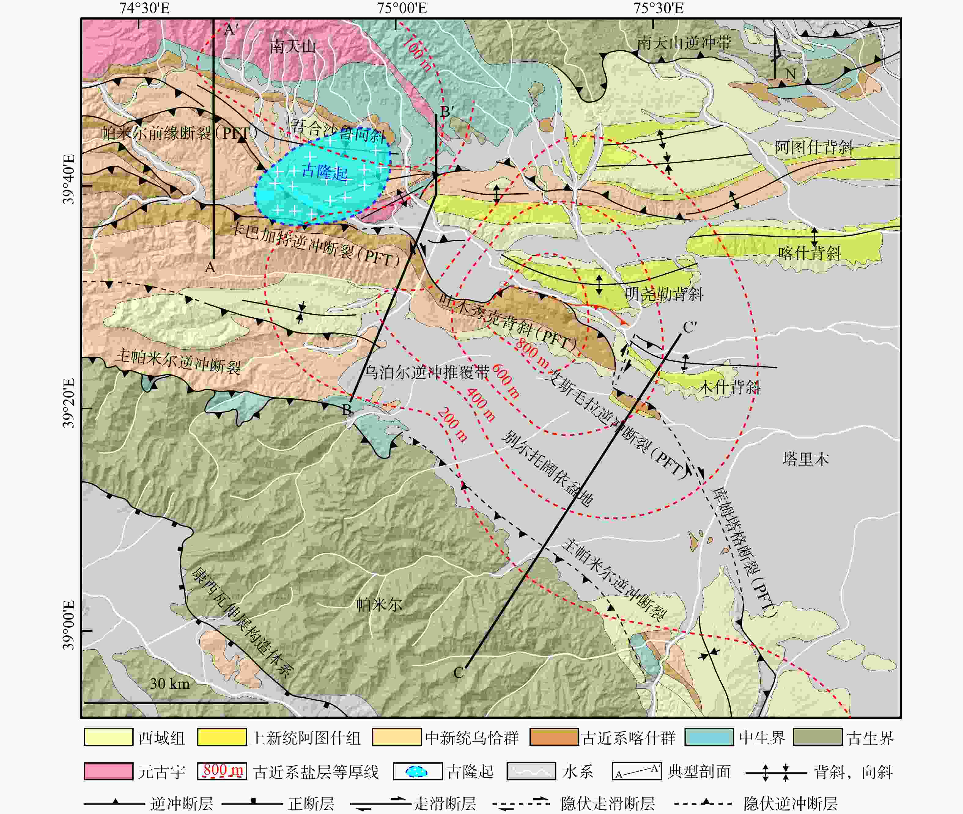
图 1 帕米尔东北缘−南天山对接带区域地质图(据Li et al.,2025修改)
Figure 1. Regional geological map of the junction between the northeastern Pamir and the southern Tian Shan (modified after Li et al., 2025)
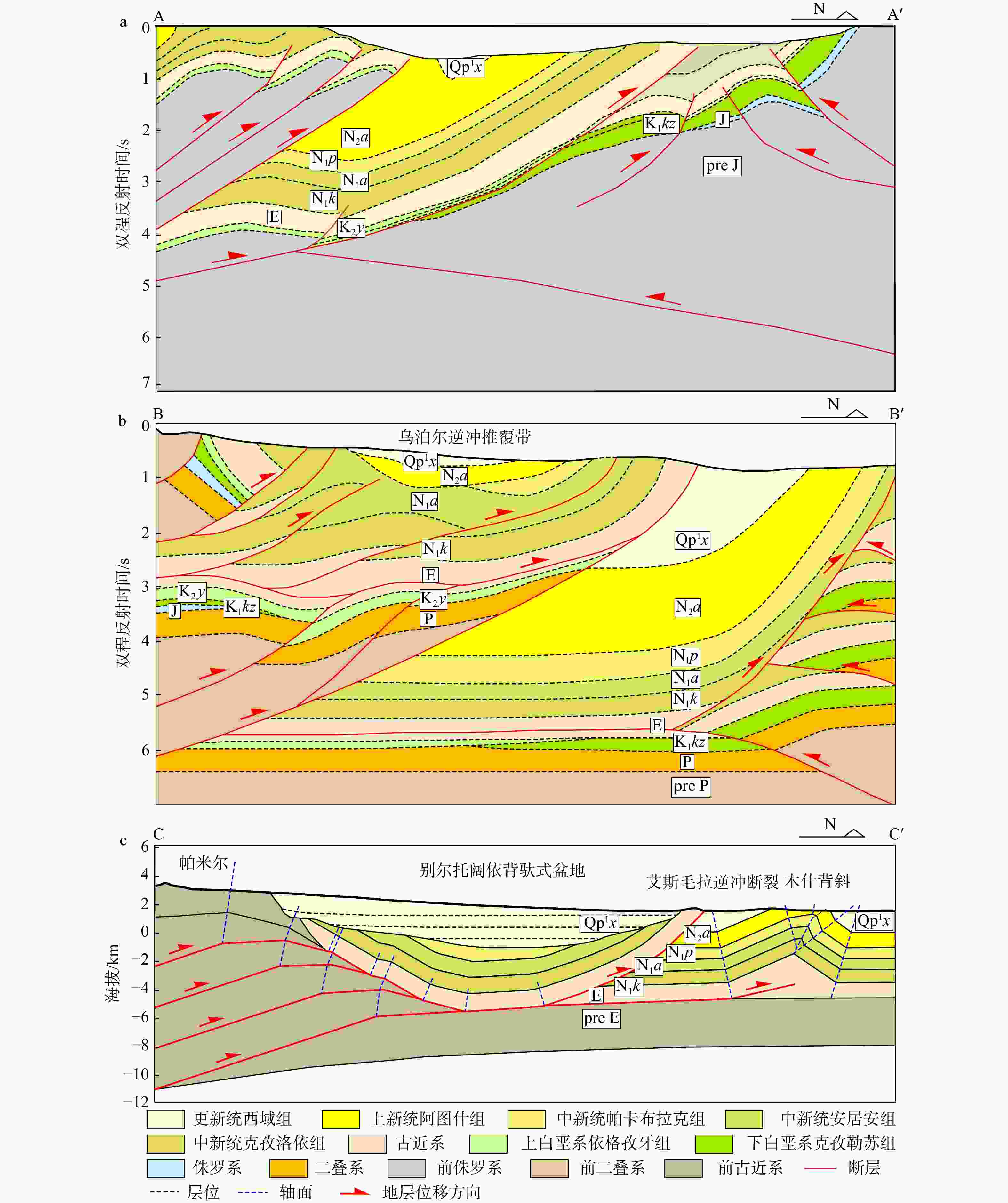
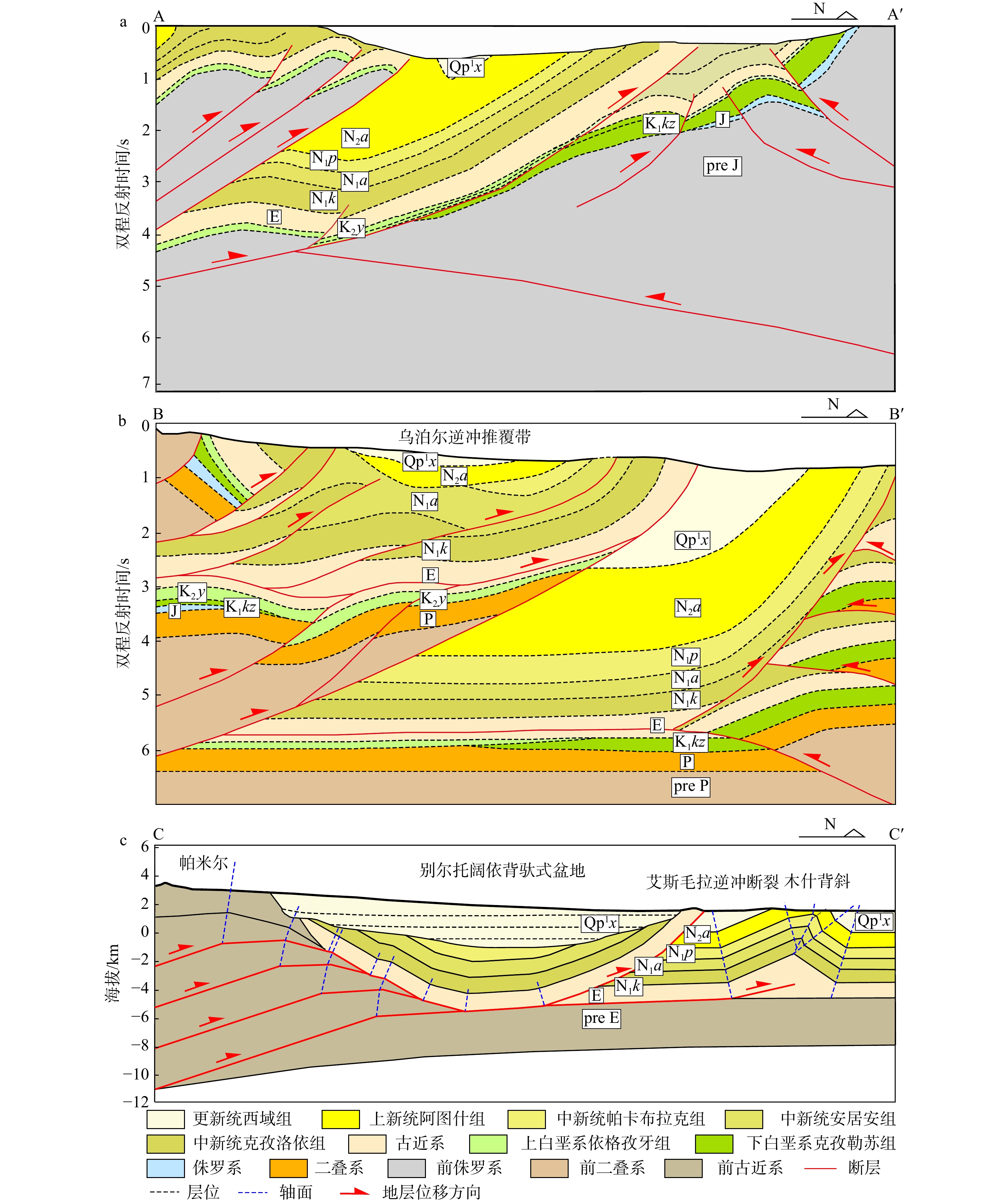
图 2 地质剖面图
a—基底断层将上覆地层切割为多个断块(剖面位置见图1 A-A′;据杨少梅,2021修改);b—基底断层呈叠瓦式构造,发育巨厚的新生代沉积(剖面位置见图1 B-B′;据杨少梅,2021修改);c—数条基底断裂收敛于滑脱层内,上覆地层向后陆反冲作用强烈(剖面位置见图1 C-C′;据Li et al.,2019修改)
Figure 2. Geological cross-sections
(a) The strata are dissected into a series of fault blocks by basement faults (the section position is shown in Fig.1, line A–A′; modified after Yang, 2021). (b) Basement faults exhibit an imbricate pattern, accompanied by extremely thick Cenozoic sediments (the section position is shown in Fig.1, line B–B′; modified after Yang, 2021). (c) Several basement faults converge into the décollement layer, and the overlying strata are marked by intense back-thrusting towards the hinterland (the section position is shown in Fig.1, line C–C′; modified after Li et al., 2019)
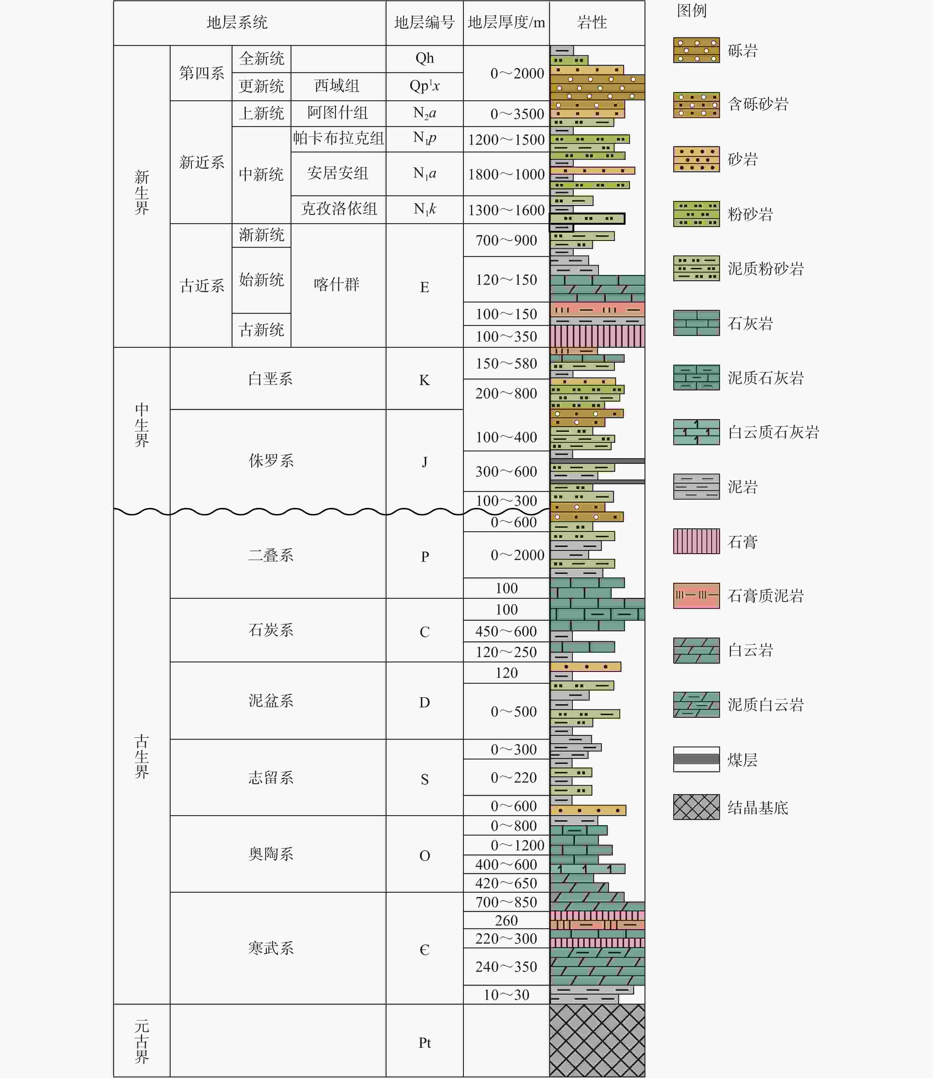
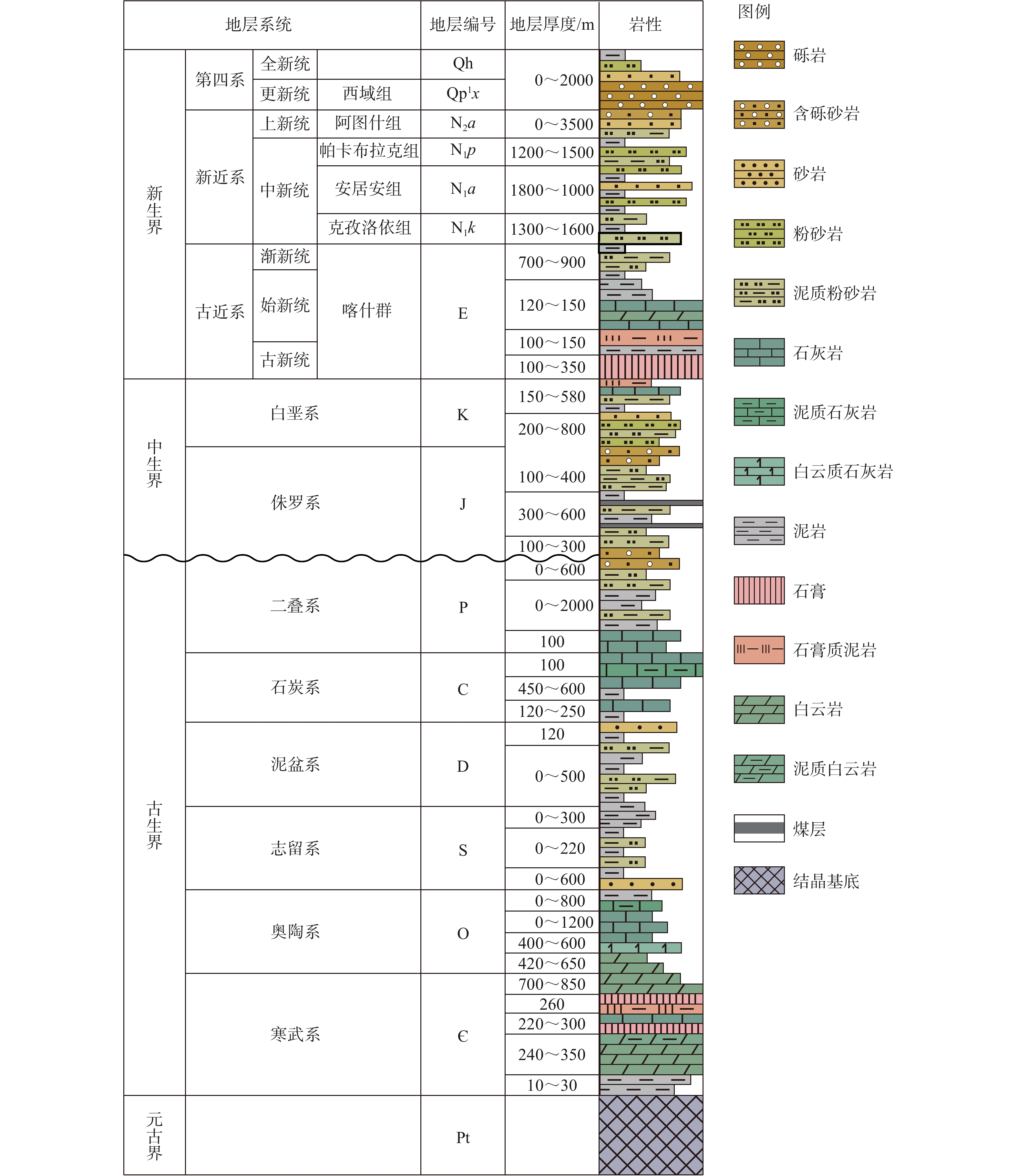
图 3 区域地层柱状图(据Li et al.,2025修改)
Figure 3. Stratigraphic column of the study area (modified after Li et al., 2025)
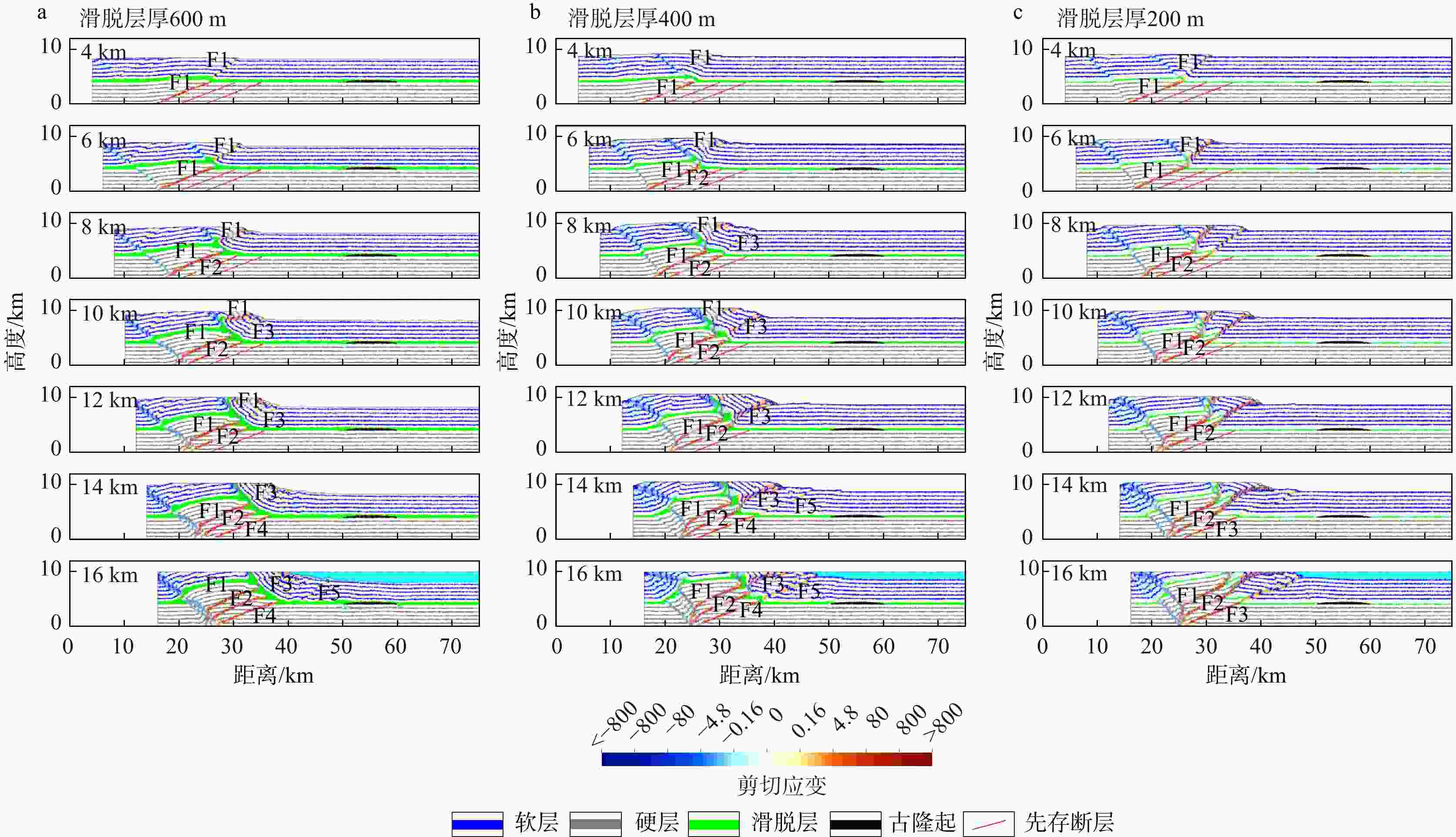
图 5 不同滑脱层厚度的模拟实验结果图
a—实验1:古近系滑脱层厚600 m,上覆地层向后陆发生明显反冲变形;b—实验2:古近系滑脱层厚400 m,上覆层不仅发育反冲构造,而且基底先存断层突破至地表;c—实验3:古近系滑脱层厚200 m,模型上下地层呈现出明显的整体变形特征
Figure 5. Simulation results of the models with different décollement layer thicknesses
(a) Experiment 1: A 600-m-thick Paleogene décollement layer, with the overlying strata exhibiting prominent back-thrusting toward the hinterland; (b) Experiment 2: A 400-m-thick Paleogene décollement layer, with the overlying strata characterized by back-thrust structures, and with pre‑existing basement faults breaking through to the surface; (c) Experiment 3: A 200-m-thick Paleogene décollement layer, with the upper and lower strata showing consistent deformation characteristics
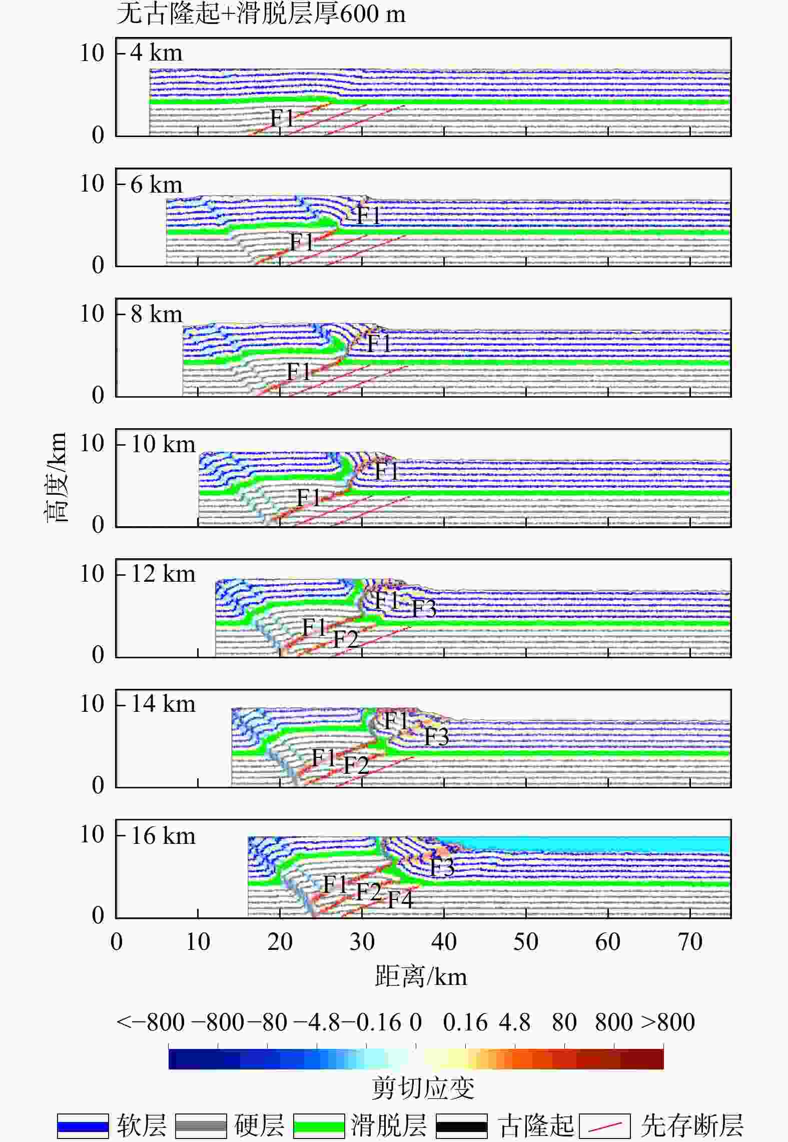
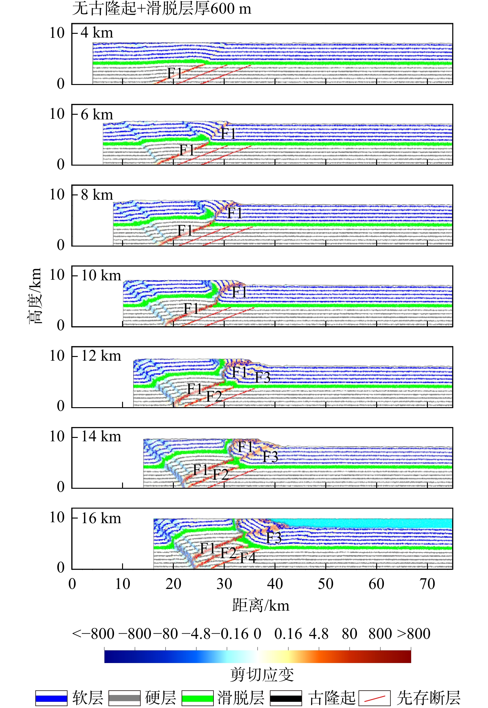
图 6 实验4模拟实验结果图
无古隆起时,模型发育指向后陆方向的反冲构造,但并未出现实验1中的前冲断层F5
Figure 6. Simulation results of Model 4
In the absence of a paleo-uplift, the model develops a backthrust structure oriented towards the hinterland, yet the F5 forethrust fault observed in Experiment 1 does not emerge.
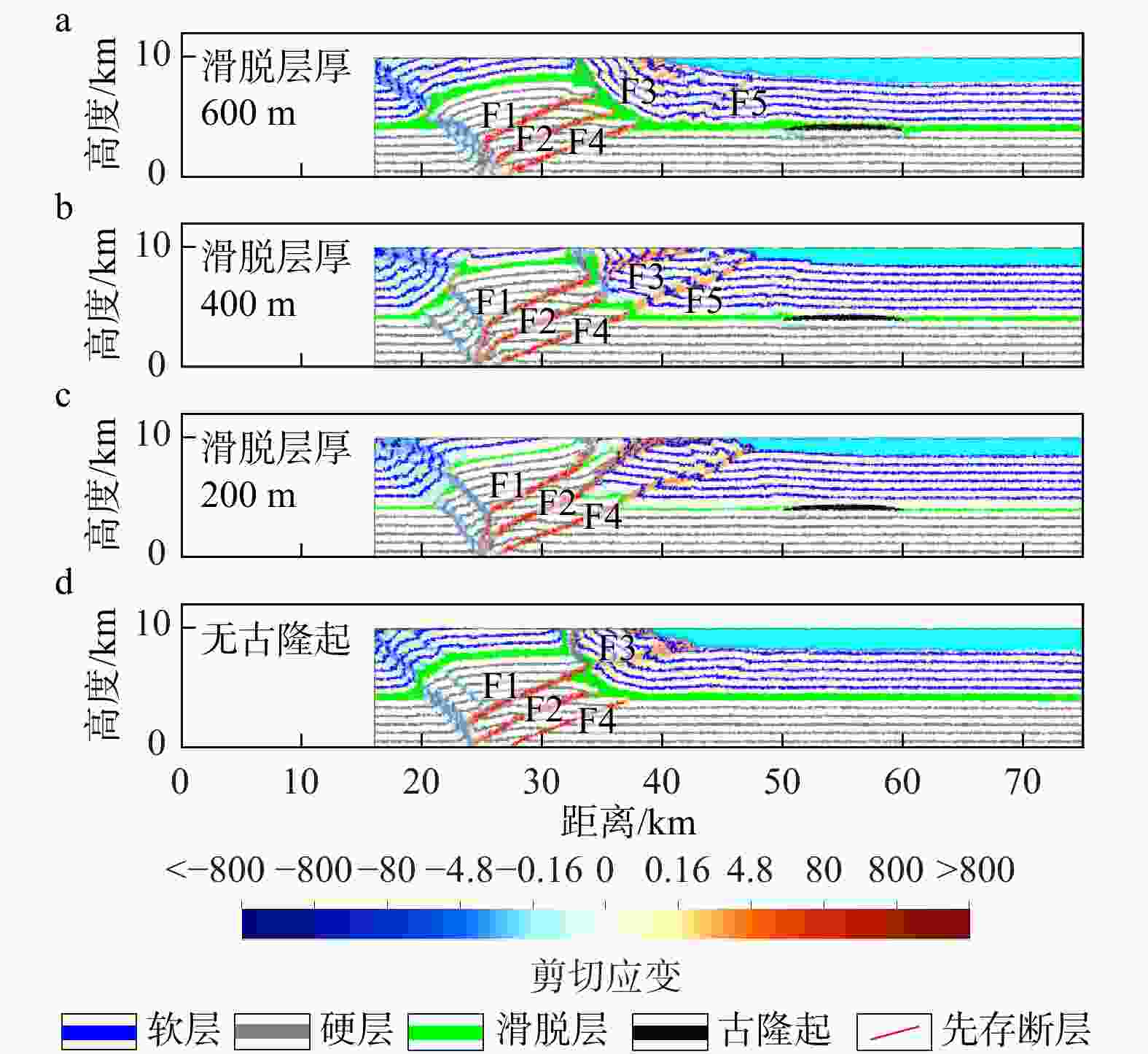
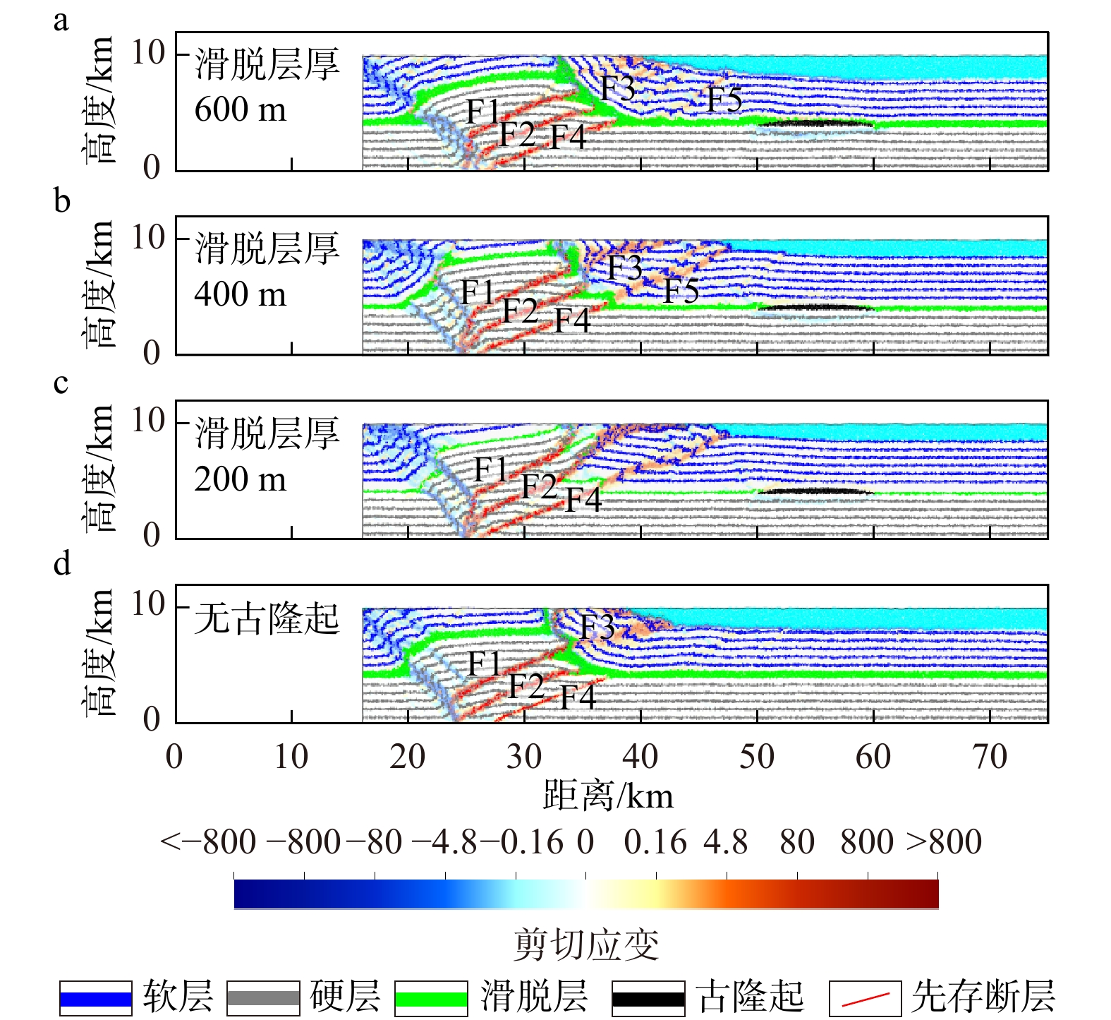
图 7 滑脱层厚度与古隆起模拟实验典型时刻对比图
a—滑脱层厚600 m,上覆盖层变形明显受到反冲构造控制,存在前冲断层F5;b—滑脱层厚400 m,上覆层发育后陆方向反冲构造,基底先存断层部分突破至地表;c—滑脱层厚200 m,基底断裂均突破至地表;d—无古隆起,滑脱层厚600 m,总体构造样式与图7a类似,但未形成前冲断裂F5
Figure 7. Comparison of detachment thickness and paleo-uplift at typical modelling time steps
(a) When the décollement layer thickness is 600 m, the deformation in the overlying strata is mainly characterized by back-thrust structures, and the frontal-thrust F5 develops; (b) When the décollement layer thickness is 400 m, the overlying strata develop back-thrust structures towards the hinterland, and pre‑existing basement faults also penetrate to the surface; (c) When the décollement layer thickness is 200 m, all basement faults penetrate the surface; (d) When there is no paleo-uplift and the décollement layer thickness is 600 m, the overall structural style resembles that in Fig.7a, but the frontal thrust F5 is absent
表 1 离散元实验模型的参数设置
Table 1. Parameter settings for the discrete-element experimental models
模拟地层 密度/
kg/m3摩擦系数 杨氏模
量/Pa剪切模
量/Pa抗拉强
度/Pa剪切强
度/Pa能干层T1 2500 0.3 2.0×10⁸ 2.0×10⁸ 1.0×10⁷ 2.0×10⁷ 能干层T2 2.0×10⁷ 4.0×10⁷ 塑性层 2200 0.0 — — — —  下载: 导出CSV
-
[1] BURCHFIEL B C, BROWN E T, DENG Q D, et al., 1999. Crustal shortening on the margins of the Tien Shan, Xinjiang, China[J]. International Geology Review, 41(8): 665-700. doi: 10.1080/00206819909465164 [2] BUTLER R W H, BOND C E, COOPER M A, et al., 2018. Interpreting structural geometry in fold-thrust belts: why style matters[J]. Journal of Structural Geology, 114: 251-273. doi: 10.1016/j.jsg.2018.06.019 [3] CAO K, WANG G C, VAN DER BEEK P, et al., 2013. Cenozoic thermo-tectonic evolution of the northeastern Pamir revealed by zircon and apatite fission-track thermochronology[J]. Tectonophysics, 589: 17-32. doi: 10.1016/j.tecto.2012.12.038 [4] CHAPMAN J B, CARRAPA B, BALLATO P, et al., 2017. Intracontinental subduction beneath the Pamir Mountains: constraints from thermokinematic modeling of shortening in the Tajik fold-and-thrust belt[J]. GSA Bulletin, 129(11-12): 1450-1471. [5] CHEN H L, LI K, LI Y, et al., 2018. The segmentation deformation of the thrust belt in front of western Kunlun, western China, and its controlling factors[J]. Acta Petrologica Sinica, 34(7): 1933-1942. (in Chinese with English abstract) [6] CHEN H L, ZHANG F F, CHENG X G, et al., 2010. The deformation features and basin-range coupling structure in the northeastern Pamir tectonic belt[J]. Chinese Journal of Geology, 45(1): 102-112. (in Chinese with English abstract) [7] CHEN J J, 2022. Cenozoic thrust deformation and genetic mechanism of the Southwestern Tarim Basin[D]. Beijing: China University of Geosciences (Beijing). (in Chinese with English abstract) [8] CHENG X G, CHEN H L, LIN X B, et al., 2016. Deformation geometry and timing of the Wupoer thrust belt in the NE Pamir and its tectonic implications[J]. Frontiers of Earth Science, 10(4): 751-760. doi: 10.1007/s11707-016-0606-z [9] COWGILL E, YIN A, HARRISON T M, et al., 2003. Reconstruction of the Altyn Tagh fault based on U‐Pb geochronology: role of back thrusts, mantle sutures, and heterogeneous crustal strength in forming the Tibetan Plateau[J]. Journal of Geophysical Research: Solid Earth, 108(B7): 2346. doi: 10.1029/2002jb002080 [10] CUNDALL P A, STRACK O D L, 1979. A discrete numerical model for granular assemblies[J]. Géotechnique, 29(1): 47-65. doi: 10.1680/geot.1979.29.1.47 [11] GAO H H, HE D F, TONG X G, et al., 2017. Tectonic-depositional environment and proto-type basin evolution of the Cambrian in the Tarim Basin[J]. Geoscience, 31(1): 102-118. (in Chinese with English abstract) [12] HE B Z, JIAO C L, HUANG T Z, et al., 2019. Structural architecture of Neoproterozoic rifting depression groups in the Tarim Basin and their formation dynamics[J]. Science China Earth Sciences, 62(3): 529-549. doi: 10.1007/s11430-018-9286-6 [13] JIA C Z, CHEN Z X, LEI Y L, et al., 2022. Deformation mechanisms and structural models of the fold-thrust belts of central and western China[J]. Earth Science Frontiers, 29(6): 156-174. (in Chinese with English abstract) [14] JIA C Z, LI B L, LEI Y L, et al., 2013. The structure of Circum-Tibetan Plateau Basin-Range System and the large gas provinces[J]. Science China Earth Sciences, 56(11): 1853-1863. doi: 10.1007/s11430-013-4649-7 [15] LABORDE A, BARRIER L, SIMOES M, et al., 2019. Cenozoic deformation of the Tarim Basin and surrounding ranges (Xinjiang, China): a regional overview[J]. Earth-Science Reviews, 197: 102891. doi: 10.1016/j.earscirev.2019.102891 [16] LI B L, JIA C Z, PANG X Q, et al., 2007. The spatial distribution of the foreland thrust tectonic deformation in the Circum-Tibetan Plateau Basin and Range System[J]. Acta Geologica Sinica, 81(9): 1200-1207. (in Chinese with English abstract) [17] LI C S, 2019. Quantitative analysis and simulation of structural deformation in the fold and thrust belt based on Discrete Element Method[D]. Nanjing: Nanjing University. (in Chinese with English abstract) [18] LI C S, YIN H W, XU W Q, et al., 2022. Quantitative analysis and simulation of compressive tectonics based on discrete element method[J]. Geotectonica et Metallogenia, 46(4): 645-661. (in Chinese with English abstract) [19] LI C Y, CHEN H L, ZHANG F Q, et al., 2021. Cenozoic basin-filling evolution of the SW Tarim Basin and its implications for the uplift of western Kunlun: insights from (seismo)stratigraphy[J]. Palaeogeography, Palaeoclimatology, Palaeoecology, 562: 110149. doi: 10.1016/j.palaeo.2020.110149 [20] LI T, CHEN Z X, CHEN J, et al., 2019. Along‐strike and downdip segmentation of the Pamir frontal thrust and its association with the 1985 MW 6.9 Wuqia earthquake[J]. Journal of Geophysical Research: Solid Earth, 124(9): 9890-9919. doi: 10.1029/2019JB017319 [21] LI Y, HUANG J L, QIU B, et al., 2025. Structural analyses of the Qimugen fold-and-thrust belt along the southwestern Tarim Basin (China): implications for tectonics of eastern Pamir and hydrocarbon exploration planning[J]. Journal of the Geological Society, 182(4): jgs2025-002. doi: 10.1144/jgs2025-002 [22] LIANG H, WANG X, CHEN W, et al., 2014. Cenozoic deformation sequence of Hetian-Kekeya structural belt in the piedmont of West Kunlun Mountains[J]. Geotectonica et Metallogenia, 38(1): 27-37. (in Chinese with English abstract) [23] LIU D M, WANG J, JIANG H, et al., 2024. Evolutionary geodynamics and remote effects of the uplift of the Qinghai-Tibet Plateau[J]. Earth Science Frontiers, 31(1): 154-169. (in Chinese with English abstract) [24] LIU J W, RAO G, BAI S, et al., 2025. Structural analysis and numerical modeling of multi-stage tectonic deformation in the Ziliujing anticline, SW Sichuan Basin, China: implications for deformation propagation in salt-bearing fold-and-thrust belts[J]. Tectonophysics, 908: 230760. doi: 10.1016/j.tecto.2025.230760 [25] LIU Z J, FAN K Y, TU G Y, et al., 2024. Deformation characteristics of salt tectonics in the western part of the Kelasu structural belt in the Kuqa Depression, Tarim Basin[J]. Natural Gas Geoscience, 35(6): 988-999. (in Chinese with English abstract) [26] LUO Q, ZHAO Z W, LIU C, et al., 2025. Numerical simulation analysis of stacking structure deformation and stress in the Wuqia structural belt of the western South Tianshan Mountains[J]. Chinese Journal of Geology, 60(5): 1259-1270. (in Chinese with English abstract) [27] MA H R, WANG M M, 2025. Structural control of induced seismicity in the Weiyuan anticline, southwestern Sichuan foreland thrust Belt, China[J]. Tectonics, 44(4): e2024TC008617. doi: 10.1029/2024TC008617 [28] MORGAN J K, 2015. Effects of cohesion on the structural and mechanical evolution of fold and thrust belts and contractional wedges: discrete element simulations[J]. Journal of Geophysical Research: Solid Earth, 120(5): 3870-3896. doi: 10.1002/2014JB011455 [29] NILFOUROUSHAN F, PYSKLYWEC R, CRUDEN A, 2012. Sensitivity analysis of numerical scaled models of fold-and-thrust belts to granular material cohesion variation and comparison with analog experiments[J]. Tectonophysics, 526-529: 196-206. [30] REN H Y, FU H, JI J, et al., 2017. Correlation of Cretaceous-Palaeogene sedimentary evolution in southwestern Tarim Basin and adjacent central Asia basins[J]. Sedimentary Geology and Tethyan Geology, 37(3): 103-112. (in Chinese with English abstract) [31] SHAW J H, CONNORS C, SUPPE J, 2005. Seismic interpretation of contractional fault-related folds: an AAPG seismic atlas[M]. Tulsa: American Association of Petroleum Geologists. [32] STEWART S A, 1996. Influence of detachment layer thickness on style of thin-skinned shortening[J]. Journal of Structural Geology, 18(10): 1271-1274. doi: 10.1016/S0191-8141(96)00052-1 [33] SUN T, 2020. Structural analysis of the piedmont fault zone in southwestern depression of Tarim Basin[D]. Beijing: China University of Petroleum (Beijing). (in Chinese with English abstract) [34] TANG P C, RAO G, LI S Q, et al., 2018. The effect of salt thickness on fold lateral linkage: a case study of the anticlines in the leading edge of the western Kuqa Fold and Thrust Belt, South Tianshan[J]. Acta Geologica Sinica, 92(3): 437-448. (in Chinese with English abstract) [35] WANG C Y, CHEN H L, CHENG X G, et al., 2013. Evaluating the role of syn-thrusting sedimentation and interaction with frictional detachment in the structural evolution of the SW Tarim basin, NW China: insights from analogue modeling[J]. Tectonophysics, 608: 642-652. doi: 10.1016/j.tecto.2013.08.016 [36] WANG C Y, CHENG X G, CHEN H L, et al., 2016. The effect of foreland palaeo-uplift on deformation mechanism in the Wupoer fold-and-thrust belt, NE Pamir: constraints from analogue modelling[J]. Journal of Geodynamics, 100: 115-129. doi: 10.1016/j.jog.2016.03.001 [37] WANG Q H, YANG H J, LI Y, et al., 2023. Major breakthrough in the Carboniferous-Permian in Well Qiatan 1 and exploration prospect in the piedmont southwestern Tarim Basin[J]. China Petroleum Exploration, 28(4): 34-45. (in Chinese with English abstract) [38] WANG Q H, YANG H J, LI Y, et al., 2024. Major oil and gas discovery and significance of Well Yetan 1 in the peripheral Kekeya area in the piedmont of the southwestern Tarim Basin[J]. China Petroleum Exploration, 29(4): 1-16. (in Chinese with English abstract) [39] WU X F, LIU S, WANG X, et al., 2004. Analysis on structural sections in the Cenozoic Pamir-western Kunlun foreland fold-and-thrust belt[J]. Chinese Journal of Geology, 39(2): 260-271. (in Chinese with English abstract) [40] XU F, LU T Q, MA Q, 2020. Analysis and Study on Sedimentary Facies of Piedmont Paleogene in Southwest Tarim Basin[J]. Chemical Engineering Design Communications, 46(12): 195-196. (in Chinese with English abstract) [41] YANG G, CHEN Z X, 2023. A two-stage evolution model of the wedged-shaped structures superposed with strike-slip faulting for the Qimugen oroclines of the Southwest Tarim Basin, Northwest China[J]. Chinese Journal of Geology, 58(2): 347-378. (in Chinese with English abstract) [42] YANG G, CHEN Z X, LU X S, et al., 2025. Mechanics and analog modeling of the Huo-Ma-Tu thrust sheet in the southern Junggar Basin fold and thrust belt[J]. Journal of Geomechanics, 31(1): 8-23. (in Chinese with English abstract) [43] YANG H J, SUN D, QIU B, et al., 2025. Breakthrough and significance of Permian oil and gas exploration in Well Duwa1 of Kedong structural belt in the southwestern piedmont of Tarim Basin[J]. Acta Petrolei Sinica, 46(11): 2013-2033. (in Chinese with English abstract) [44] YANG S M, 2021. Cenozoic convergence between the northeastern Pamir and the South Tianshan: insights from structural features and sedimentary records[D]. Hangzhou: Zhejiang University. (in Chinese with English abstract) [45] YANG W X, RAO G, TANG P C, et al., 2025. Discrete-element numerical simulations of thrust-related folding: insights into back-limb deformation[J]. Journal of Structural Geology, 197: 105442. doi: 10.1016/j.jsg.2025.105442 [46] YUE Y, XU Q Q, FU H, et al., 2017. Reservoir-cap rock assemblage and sedimentary characteristics of Cretaceous-Paleogene in southwestern Tarim Basin[J]. Petroleum Geology & Experiment, 39(3): 318-326. (in Chinese with English abstract) [47] ZHAO Y L, SUN Y J, HOU G T, et al., 2025. The outward growth of the arcuate tectonic belt in the northeastern Tibetan Plateau: Insights from three-dimensional finite element numerical simulations[J]. Journal of Geomechanics, 31(3): 361-385. (in Chinese with English abstract) doi: 10.3390/jmse13010170 [48] ZHENG W J, SUN X, YUAN D Y, et al., 2025. Active faults, seismic activity, and seismotectonic environments in the Tibetan Plateau and its adjacent regions[J]. Journal of Geomechanics, 31(5): 1006-1029. (in Chinese with English abstract) [49] ZHOU C, HE J K, SU H, et al., 2024. Discrete element modeling of distal deformation propagation in thrust wedge and implications for early deformation on northern Tibetan and Iranian Plateaus[J]. Journal of Structural Geology, 184: 105150. doi: 10.1016/j.jsg.2024.105150 [50] ZHU Y Z, LI C X, JIANG X Y, et al., 2025. Differential salt-related structural deformation in the eastern segment of the Qiulitage fold and thrust belt, Kuqa Foreland Basin: evidences from seismic interpretation and numerical simulation analysis[J]. Journal of Structural Geology, 194: 105372. doi: 10.1016/j.jsg.2025.105372 [51] 陈汉林, 李康, 李勇, 等, 2018. 西昆仑山前冲断带的分段变形特征及控制因素[J]. 岩石学报, 34(7): 1933-1942. [52] 陈汉林, 张芬芬, 程晓敢, 等, 2010. 帕米尔东北缘地区构造变形特征与盆山结构[J]. 地质科学, 45(1): 102-112. [53] 陈槚俊, 2022. 塔西南新生代冲断构造变形及成因机制[D]. 北京: 中国地质大学(北京). [54] 高华华, 何登发, 童晓光, 等, 2017. 塔里木盆地寒武纪构造−沉积环境与原型盆地演化[J]. 现代地质, 31(1): 102-118. doi: 10.3969/j.issn.1000-8527.2017.01.009 [55] 贾承造, 陈竹新, 雷永良, 等, 2022. 中国中西部褶皱冲断带构造变形机制与结构模型[J]. 地学前缘, 29(6): 156-174. doi: 10.13745/j.esf.sf.2022.8.2 [56] 贾承造, 李本亮, 雷永良, 等, 2013. 环青藏高原盆山体系构造与中国中西部天然气大气区[J]. 中国科学: 地球科学, 43(10): 1621-1631. [57] 李本亮, 贾承造, 庞雄奇, 等, 2007. 环青藏高原盆山体系内前陆冲断构造变形的空间变化规律[J]. 地质学报, 81(9): 1200-1207. [58] 李长圣, 2019. 基于离散元的褶皱冲断带构造变形定量分析与模拟[D]. 南京: 南京大学. [59] 李长圣, 尹宏伟, 徐雯峤, 等, 2022. 基于离散元的挤压构造定量分析与模拟[J]. 大地构造与成矿学, 46(4): 645-661. doi: 10.16539/j.ddgzyckx.2022.04.001 [60] 梁瀚, 汪新, 陈伟, 等, 2014. 西昆仑山前和田−柯克亚挤压构造带新生代变形时序及其地质意义[J]. 大地构造与成矿学, 38(1): 27-37. [61] 刘德民, 王杰, 姜淮, 等, 2024. 青藏高原形成演化动力机制及其远程效应[J]. 地学前缘, 31(1): 154-169. doi: 10.13745/j.esf.sf.2024.1.146 [62] 刘恣君, 范坤宇, 涂国煜, 等, 2024. 塔里木盆地库车坳陷克拉苏构造带西部盐相关构造变形[J]. 天然气地球科学, 35(6): 988-999. [63] 罗强, 赵振伟, 刘畅, 等, 2025. 南天山西段乌恰构造带堆垛构造变形及应力数值模拟分析[J]. 地质科学, 60(5): 1259-1270. doi: 10.12017/dzkx.2025.083 [64] 任泓宇, 傅恒, 纪佳, 等, 2017. 塔里木盆地西南地区与相邻中亚盆地白垩系−古近系沉积演化对比[J]. 沉积与特提斯地质, 37(3): 103-112. [65] 孙统, 2020. 塔里木盆地塔西南坳陷山前断裂带构造解析[D]. 北京: 中国石油大学(北京). [66] 唐鹏程, 饶刚, 李世琴, 等, 2018. 盐层厚度对褶皱拼接样式的影响: 以库车褶皱−冲断带西段前缘背斜带为例[J]. 地质学报, 92(3): 437-448. [67] 王清华, 杨海军, 李勇, 等, 2023. 塔西南山前地区恰探1井石炭系–二叠系重大突破与勘探前景[J]. 中国石油勘探, 28(4): 34-45. [68] 王清华, 杨海军, 李勇, 等, 2024. 塔西南山前地区柯克亚周缘叶探1井油气勘探重大突破及意义[J]. 中国石油勘探, 29(4): 1-16. [69] 伍秀芳, 刘胜, 汪新, 等, 2004. 帕米尔—西昆仑北麓新生代前陆褶皱冲断带构造剖面分析[J]. 地质科学, 39(2): 260-271. [70] 徐斐, 陆廷清, 马青, 2020. 塔西南山前古近系沉积相分析与研究[J]. 化工设计通讯, 46(12): 195-196. doi: 10.3969/j.issn.1003-6490.2020.12.098 [71] 杨庚, 陈竹新, 鲁雪松, 等, 2025. 准南逆冲褶皱带霍−玛−吐逆冲岩席发育力学机制与模拟实验[J]. 地质力学学报, 31(1): 8-23. [72] 杨海军, 孙迪, 邱斌, 等, 2025. 塔西南山前地区柯东构造带杜瓦1井二叠系油气勘探突破及意义[J]. 石油学报, 46(11): 2013-2033. [73] 杨少梅, 2021. 帕米尔东北缘与南天山新生代对接过程: 基于构造特征与沉积记录[D]. 杭州: 浙江大学. [74] 岳勇, 徐勤琪, 傅恒, 等, 2017. 塔里木盆地西南部白垩系—古近系沉积特征与储盖组合[J]. 石油实验地质, 39(3): 318-326. doi: 10.11781/sysydz201703318 [75] 赵一霖, 孙玉军, 侯贵廷, 等, 2025. 青藏高原东北缘弧形构造生长: 来自三维有限元数值模拟的启示[J]. 地质力学学报, 31(3): 361-385. doi: 10.12090/j.issn.1006-6616.2025037 [76] 郑文俊, 孙鑫, 袁道阳, 等, 2025. 青藏高原及邻区活动断裂、地震活动及地震构造环境[J]. 地质力学学报, 31(5): 1006-1029. doi: 10.12090/j.issn.1006-6616.2025124 -

 下载:
下载:


计量
- 文章访问数: 134
- HTML全文浏览量: 30
- PDF下载量: 88
- 被引次数: 0
