


Similarity in geomorphic physical modeling and its application to tectonic geomorphology: A review
-
摘要: 构造地貌物理模拟实验是理解构造−气候−地表过程相互作用的重要工具。文章系统综述了构造地貌物理模拟实验中模型与自然界地貌之间的相似性研究进展。从流域形态自相似性、河道弯曲度、间距比、Hack定律、面积−高程积分、坡度−面积关系及河流裂点迁移等多个地貌参数入手,梳理了以往研究实验与自然系统对比方面的成果与挑战。研究表明,尽管实验在几何、材料与动力学尺度上存在显著差异,但实验模型仍能再现自然界地貌的若干结构特征与演化规律。然而,实验材料的物理性质、模型边界条件、侵蚀机制简化等因素仍对相似性验证构成限制。未来仍需进一步结合高精度观测、多过程耦合模拟与数值模型验证,推动构造地貌物理模拟在定量解释构造活动、气候变化与地貌响应中的深入应用。Abstract:
Objective In tectonic geomorphology, physical modeling is a key tool for investigating the interactions between tectonics, climate and surface processes. A fundamental challenge lies in establishing similarity between analog laboratory experiments and natural landscapes, which differ greatly in scale, materials, and boundary conditions. This review systematically evaluates progress and remaining challenges in similarity in analog modeling. Methods This paper reviews experimental studies using silica powder or the “MatIV” composite material under controlled conditions of rainfall and tectonic uplift. A comparative framework based on geomorphic parameters (basin self-similarity, sinuosity, spacing ratio, Hack’s law, hypsometric integral, slope-area relationships, knickpoint migration, erosion rates, and χ analysis) is adopted to identify consistent findings and discrepancies between experimental and natural landscapes. Results In terms of similarity in fluvial morphology, experimental drainage basins exhibit self-similarity over a range of scales, with shape parameters (spacing ratio, Hack exponent) falling within natural ranges. Hypsometric integrals transition from convex to S-shaped as uplift slows, mimicking mature landscapes. The concavity index approaches natural values in sufficiently large basins. Regarding erosion process similarity, experimental erosion rates increase nonlinearly with slope, and a clear shift from fluvial incision to gravity-dominated erosion occurs on steeper slopes, mirroring natural behavior. Derived time scaling has been validated across compressional, extensional, and strike-slip settings. Knickpoint retreat follows a power law with upstream area and can migrate at a constant rate, indicating an intrinsic landscape response. With respect to erosional dynamics similarity, experimental erosion regimes are mixed: detachment-limited in headwaters and transport-limited downstream. The χ value successfully predicts main drainage divide migration toward higher χ values, consistent with theoretical expectations and natural observations. Conclusions Despite differences in large-scale and material, analog experiments reproduce key features of natural tectonic landscapes in terms of morphology, erosion processes, and erosional dynamics, including self-similarity, Hack scaling, knickpoint dynamics, and divide migration. This “unreasonable effectiveness” arises from the scale independence of landscape dynamics. Current limitations include lower concavity indices in small basins, insufficient quantification of the steepness index, boundary effects on sinuosity, and oversimplified erosion mechanisms. Significance This review provides a systematic synthesis of similarity criteria for physical models of tectonic geomorphology, bridging analog experiments and natural landscapes. It also offers a practical framework for model validation and future quantitative applications in tectonic and climatic research. -
Key words:
- tectonic geomorphology /
- physical modeling /
- similarity /
- geomorphic parameters /
- erosional dynamics
-
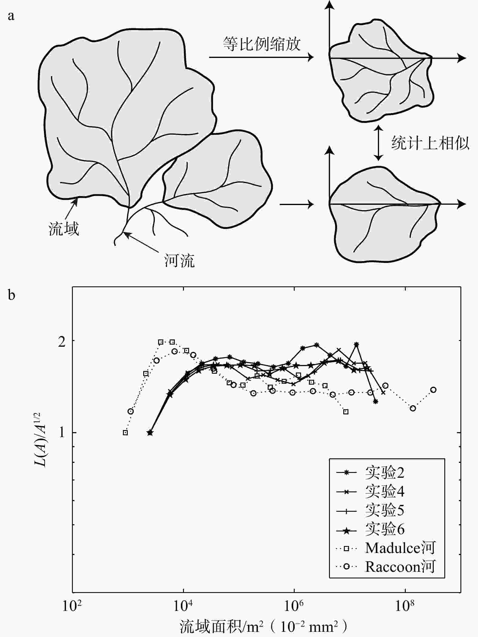
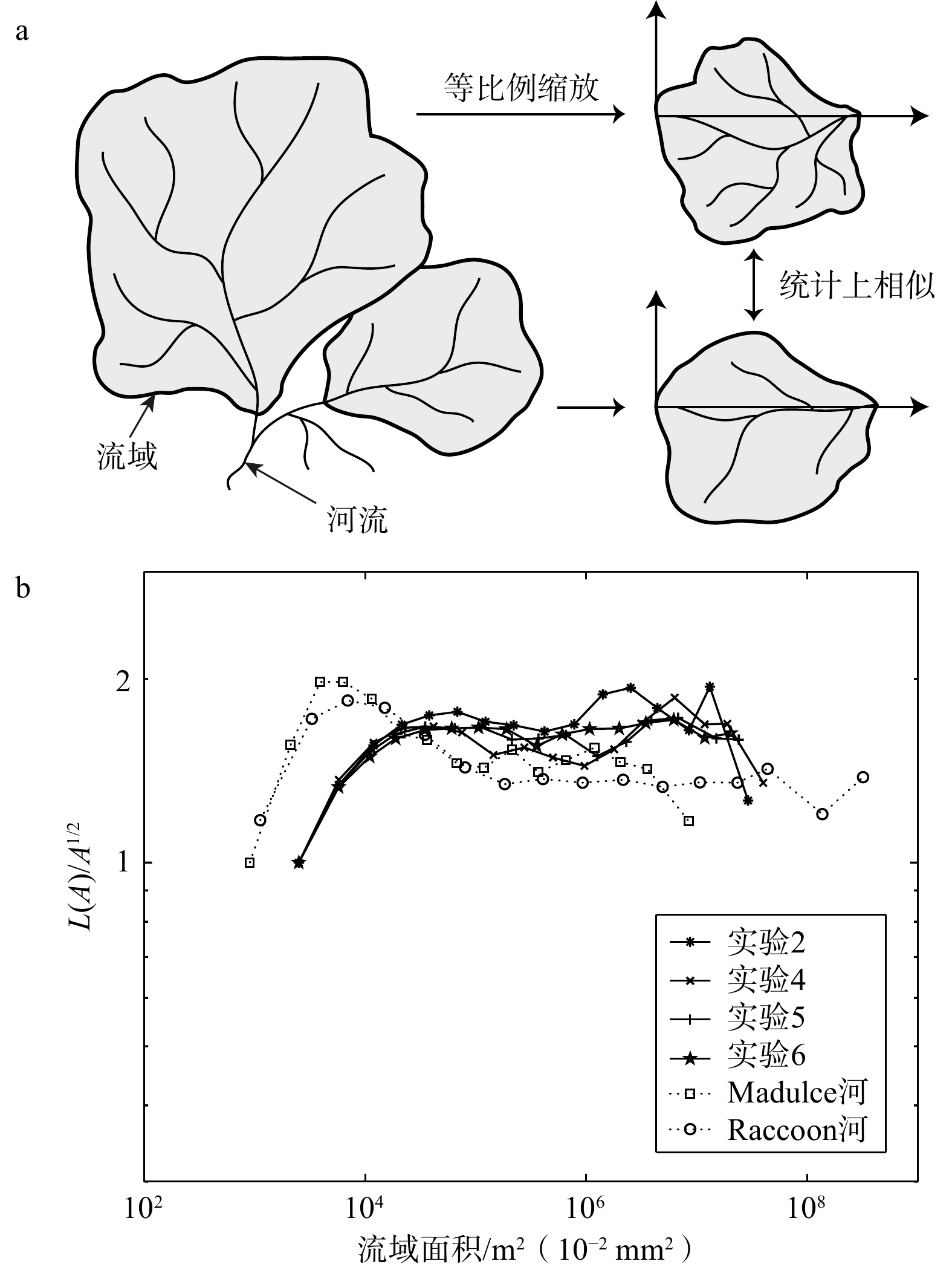
图 1 流域自相似性 (据Niemann and Hasbargen,2005修改)
L(A)—欧几里得盆地长度;A—流域面积a—流域平面自相似性示意图;b—实验流域形状与自然流域形状的对比
Figure 1. Self-similarity of drainage basins (modified from Niemann and Hasbargen, 2005)
(a) Illustration of the horizontal self-similarity condition; (b) Comparison of experimental and natural basin shapes L(A)—euclidean basin length; A—drainage area
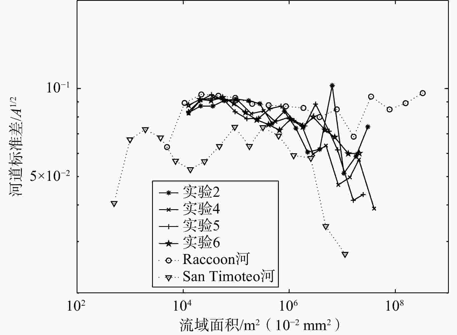
图 2 实验河道与自然河道的弯曲度对比(据Niemann and Hasbargen,2005修改)
A—流域面积
Figure 2. Comparison of the sinuosity of experimental and natural channels (modified from Niemann and Hasbargen, 2005) A—drainage area
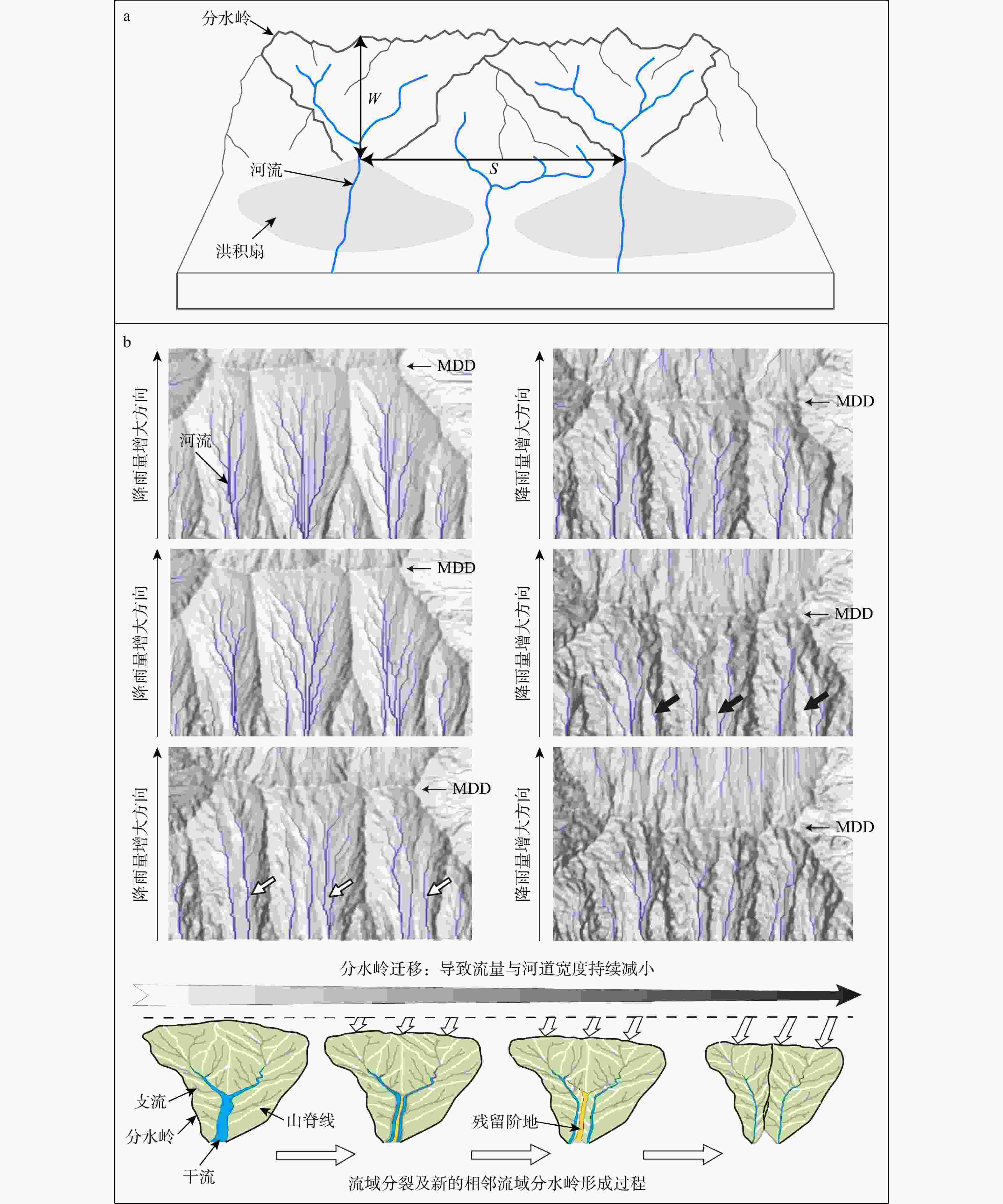
图 3 流域趋于保持一定间距比的说明图
W—自山前至流域分水岭的垂直距离; S—相邻流域出水口之间的直线距离a—间距比R值测量参数示意图 (Hovius,1996;Purdie and Brook,2006);b—主要分水岭(MDD)迁移过程及河流地貌响应过程的晕渲地形图及流域分割过程示意图 (Bonnet,2009)
Figure 3. Schematic diagram illustrating that drainage basins tend to maintain a certain spacing ratio
(a) Schematic diagram of the parameters used to measure the spacing ratio R (Hovius, 1996; Purdie and Brook, 2006); (b) Shaded relief map illustrating the migration of the main drainage divide (MDD) and the fluvial geomorphic response, and schematic diagram showing the watershed segmentation (Bonnet, 2009) W—vertical distance from the mountain front to the drainage divide; S—straight-line distance between adjacent basin outlets
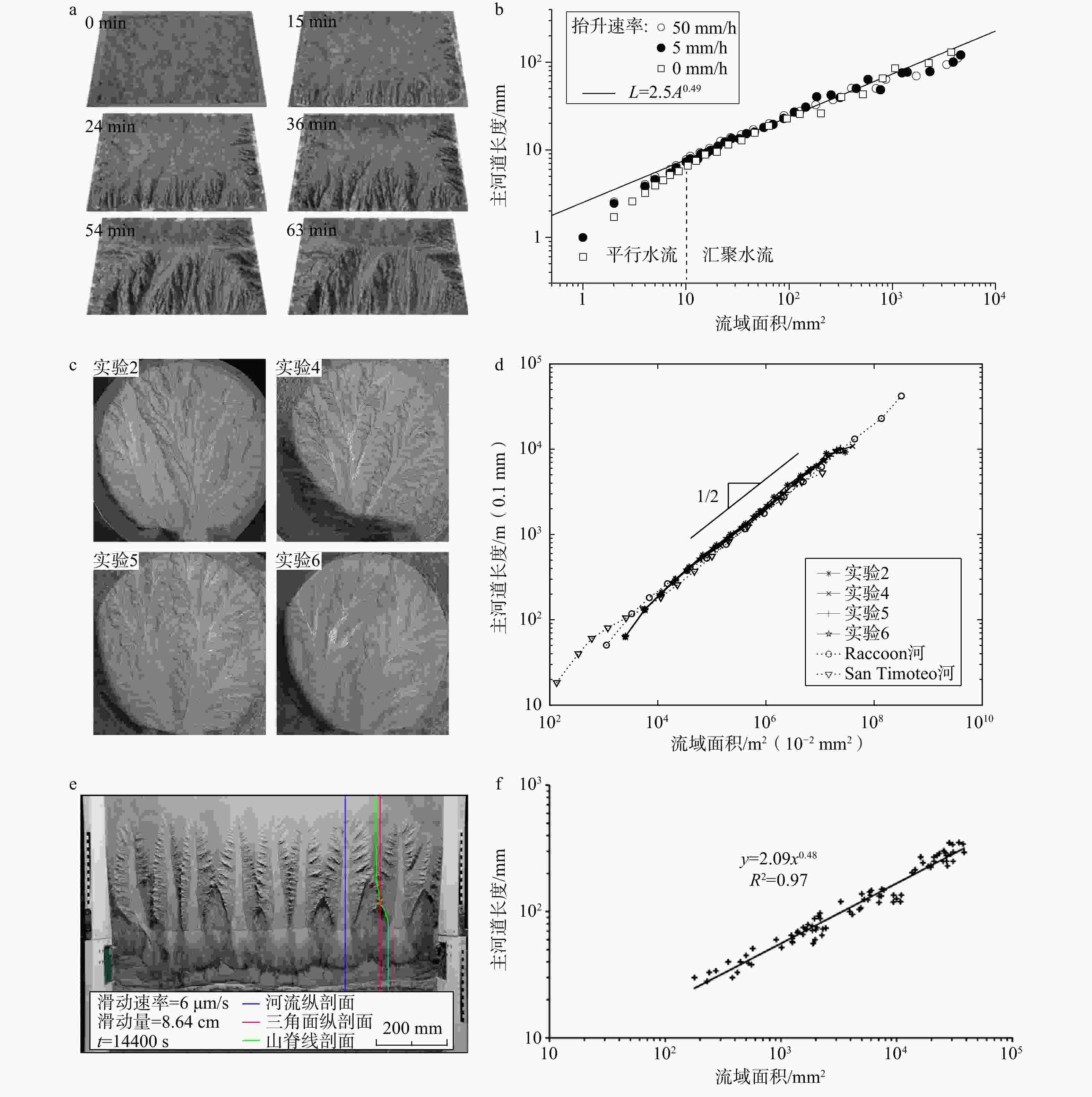
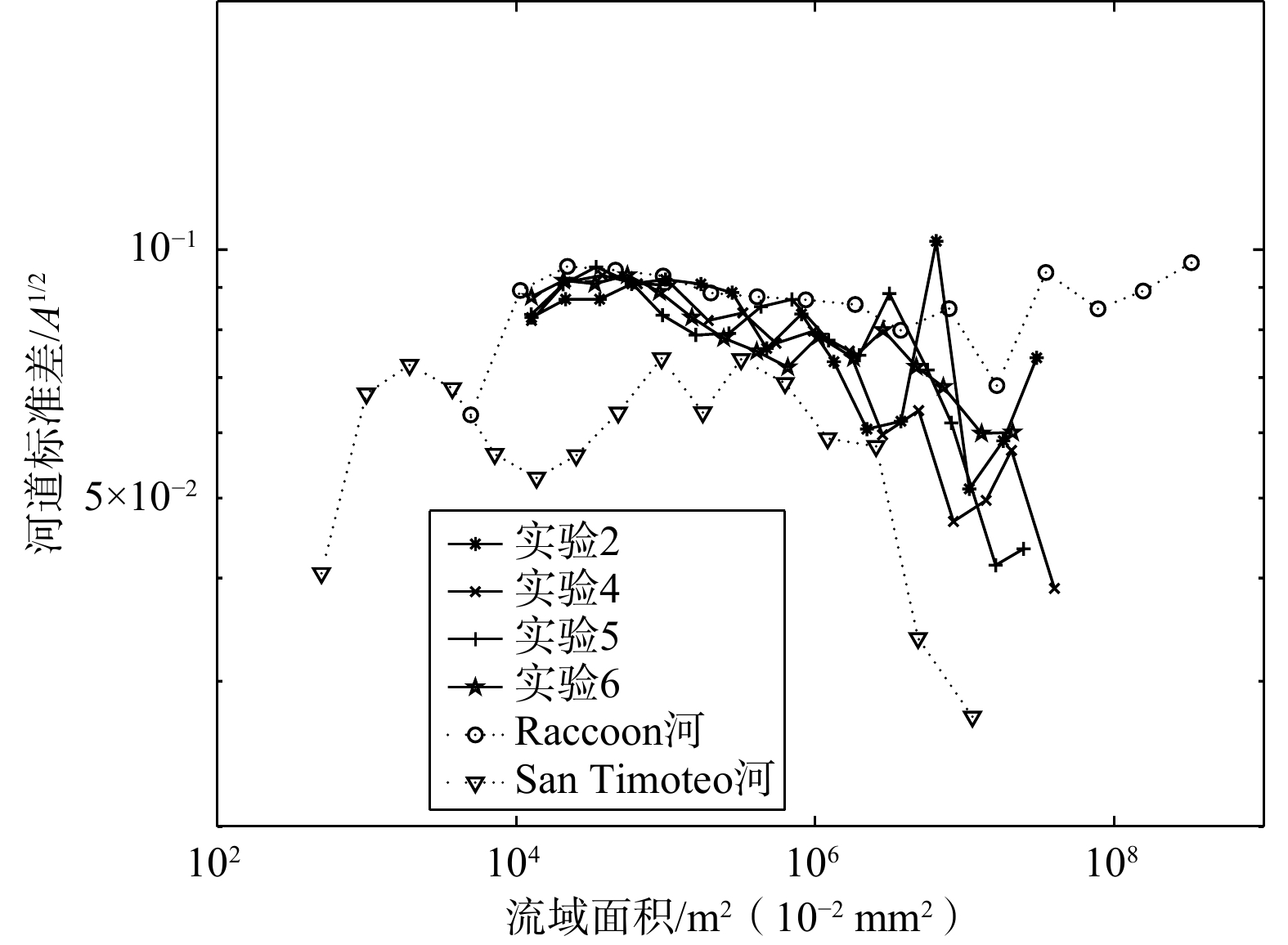
图 4 以往研究中的模拟实验及其主河道长度与流域面积关系
L—河道长度; A—流域面积a—Lague et al. (2003) 实验主要过程照片;b—Lague et al. (2003) 实验中主河道长度与流域面积的关系;c—Niemann and Hasbargen (2005) 4个实验最终照片;d—Niemann and Hasbargen (2005)实验及2条自然界河道的主河道长度与流域面积的关系(图中1/2为主河道长度与流域面积的比值);e—Strak et al. (2011)实验(滑动速率6 μm/s)最终照片;f—Strak et al. (2011)实验中主河道长度与流域面积的关系
Figure 4. Experiments in previous studies and the relationship between main channel length and drainage basin area
(a) Photographs of the main experimental process from Lague et al. (2003); (b) Relationship between main channel length and drainage area in the experiments of Lague et al. (2003); (c) Final photographs of four experiments from Niemann and Hasbargen (2005); (d) Relationship between main channel length and drainage area in the experiments of Niemann and Hasbargen (2005) and two natural river channels (the “1/2” in the figure indicates the ratio of main channel length to drainage area); (e) Final photograph of the experiment from Strak et al. (2011) at a slip rate of 6 μm/s; (f) Relationship between main channel length and drainage area in the experiment of Strak et al. (2011). L—channel length; A—drainage area
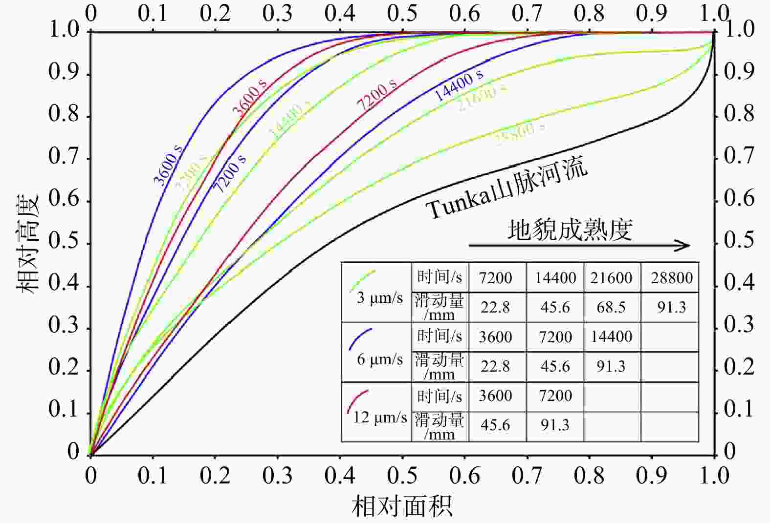
图 5 3个实验(滑动量分别为3、6、12 μm/s)不同阶段下盘的面积−高程积分曲线以及Tunka山脉的面积−高程积分曲线(Strak et al.,2011)
Figure 5. Hypsometric curves for the whole footwall at several stages of three experiments (slip rates are 3, 6, 12 μm/s, respectively). The hypsometric curve for the Tunka mountain range is shown for comparison (Strak et al., 2011)

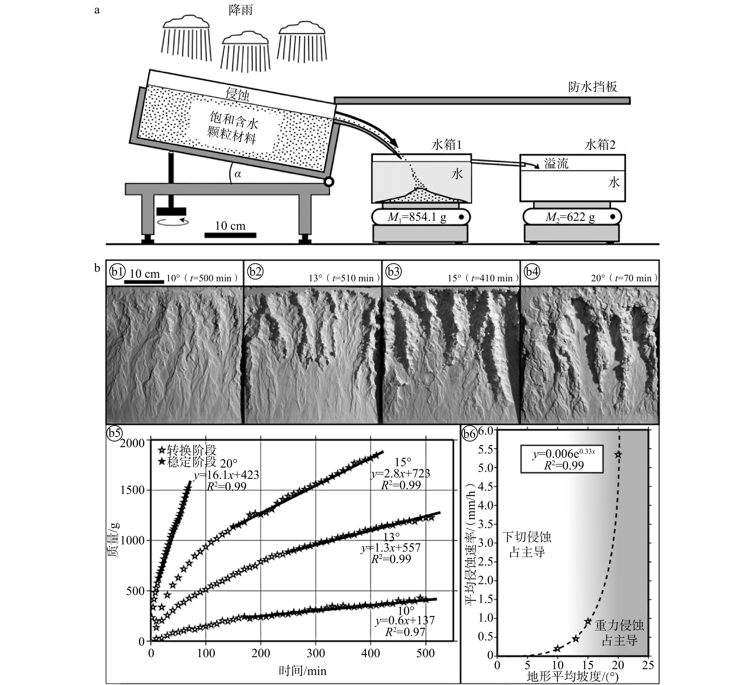
图 6 Graveleau et al. (2011) 测定“MatIV”材料侵蚀速率的方法及结果
a— Graveleau et al. (2011) 设计的测量实验材料侵蚀通量的实验装置(实验箱倾斜角度α可调,被侵蚀的颗粒落入装有水的水箱1,多余的水溢流至水箱2,2个水箱的质量变化通过天平进行记录,图中M1和M2分别为水箱1和2的质量);b——不同初始坡度下“MatIV”材料的平均侵蚀速率测定结果(b1—b4—不同初始坡度下最终阶段形态的照片;b5—不同表面坡度下侵蚀颗粒质量随时间的变化曲线;b6—平均侵蚀速率随坡度的变化曲线)
Figure 6. Method and results of measuring the erosion rate of the "MatIV" material by Graveleau et al. (2011)
(a) Experimental setup designed by Graveleau et al. (2011) to measure the weight of eroded materials (the tilt angle α of the experimental box is adjustable; eroded particles fall into water tank 1, excess water overflows into tank 2; the mass changes of the two tanks are recorded by balances; M1 and M2 denote the masses of tank 1 and tank 2, respectively); (b) Average erosion rates of the “MatIV” material at different initial slopes, including: photographs of the final morphology at different initial slopes (b1 to b4); curves of the particle mass eroded over time for different surface slopes (b5); curves of the average erosion rate as a function of slope (b6)
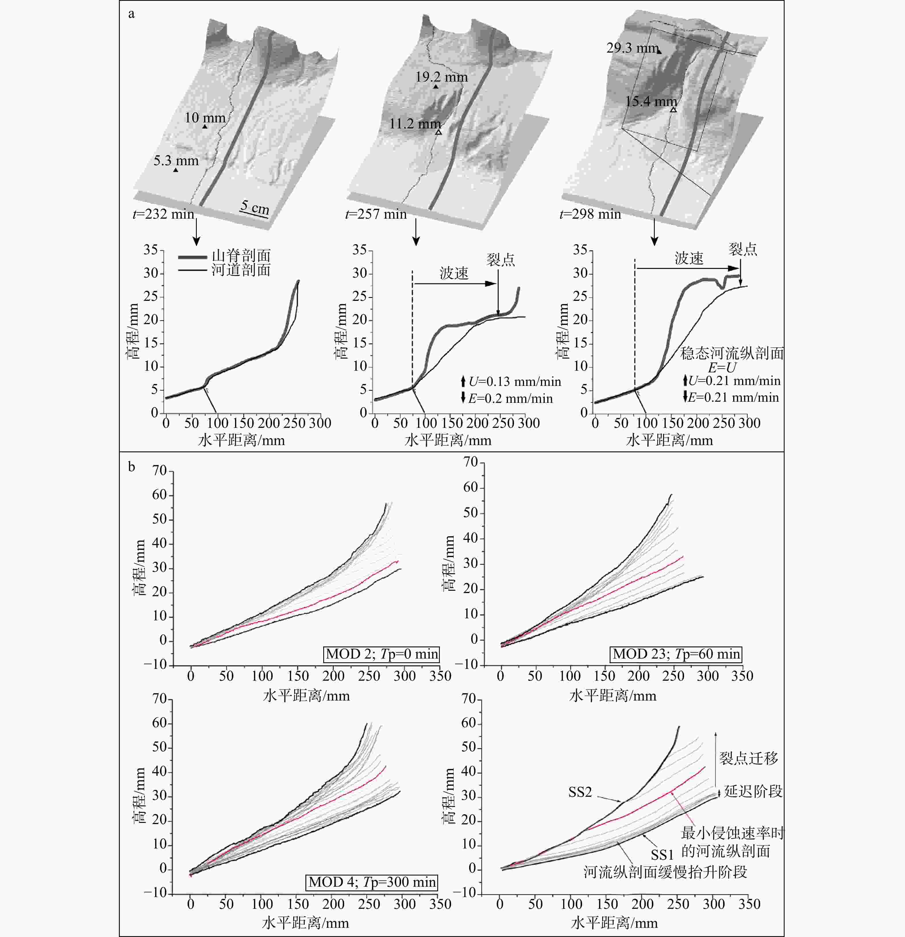
图 7 已有模拟研究中观察到的裂点迁移现象
E—侵蚀速率;U—抬升速率;Tp—红色河流纵剖面所在的实验时间a—河道持续下切三维透视图以及山脊线和河流纵剖面(裂点在t=232 min形成并向上游迁移,t=2298 min河道侵蚀速率与相对抬升速率0.21 mm/min达到平衡,该段河道处于稳态;据Viaplana-Muzas et al.,2015修改);b—实验MOD2、MOD23、MOD4在降水减少过程中(从均衡状态SS1阶段到均衡状态SS2阶段)河流纵剖面的演化过程以及河流纵剖面及裂点迁移演化示意性图(相邻剖面时间间隔为20 min;据Moussirou and Bonnet,2018修改)
Figure 7. Knickpoint migration phenomena observed in previous modeling studies
(a) 3D perspective view of continuous river incision, showing ridge lines and longitudinal river profiles. a knickpoint formed at t = 232 min and migrated upstream; by t = 298 min, the channel erosion rate balanced the relative uplift rate of 0.21 mm/min, and this reach of the river reached steady state (modified from Viaplana-Muzas et al., 2015); (b) Evolution of longitudinal river profiles during precipitation decrease (from steady-state stage SS1 to steady-state stage SS2) in experiments MOD2, MOD23, and MOD4 (consecutive profiles are 20 min apart), together with a schematic diagram illustrating the evolution of the longitudinal river profile and knickpoint migration (modified from Moussirou and Bonnet, 2018) E—erosion rate; U—uplift rate; Tp—experimental time at which the red river longitudinal profile was recorded
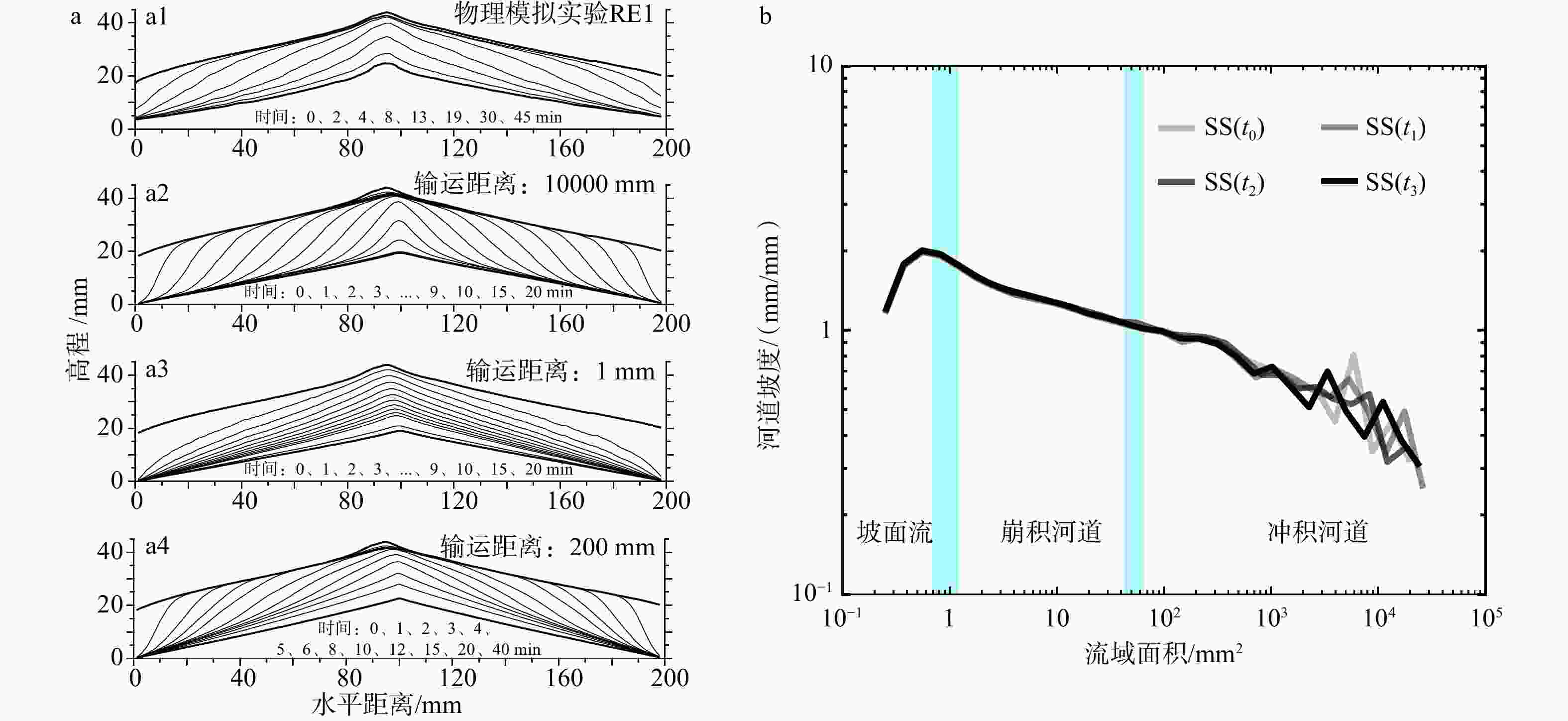
图 8 已有模拟研究中的侵蚀模式分析图
SS—均衡状态a—Lague et al. (2003) 研究中物理模拟实验和数值模拟实验的侵蚀过程结果对比(a1—实验RE1中心区域7 cm宽的条带剖面的平均地形剖面;a2—a4—输运距离分别为10000 mm、1 mm和200 mm的数值模拟实验的地形剖面);b—Tejedor et al. (2017) 模拟实验中稳态地貌的4条坡度−面积曲线(时间间隔为5 min,这些曲线显示的是对数面积区间内的平均值,SS(t0)到SS(t3)分别为t0到t3时刻的均衡状态,垂直浅蓝色条带标示了不同侵蚀类型的过渡带)
Figure 8. Analysis of erosion patterns in previous modeling studies
(a) Comparison of results from physical experiments and numerical simulations of erosion in the study of Lague et al. (2003). (a1) Average topographic profile from the central area of experiment RE1 (using a 7-cm-wide strip profile; (a2) to (a4) Topographic profiles from numerical experiments with transport distances of 10,000 mm, 1 mm, and 200 mm, respectively; (b) Four slope-area curves for a steady-state landscape, with a time interval of 5 mins in the modeling by Tejedor et al. (2017). Note that these curves show averages over logarithmic area bins. The vertical light blue bars depict the transitions between different erosion types. SS—steady state
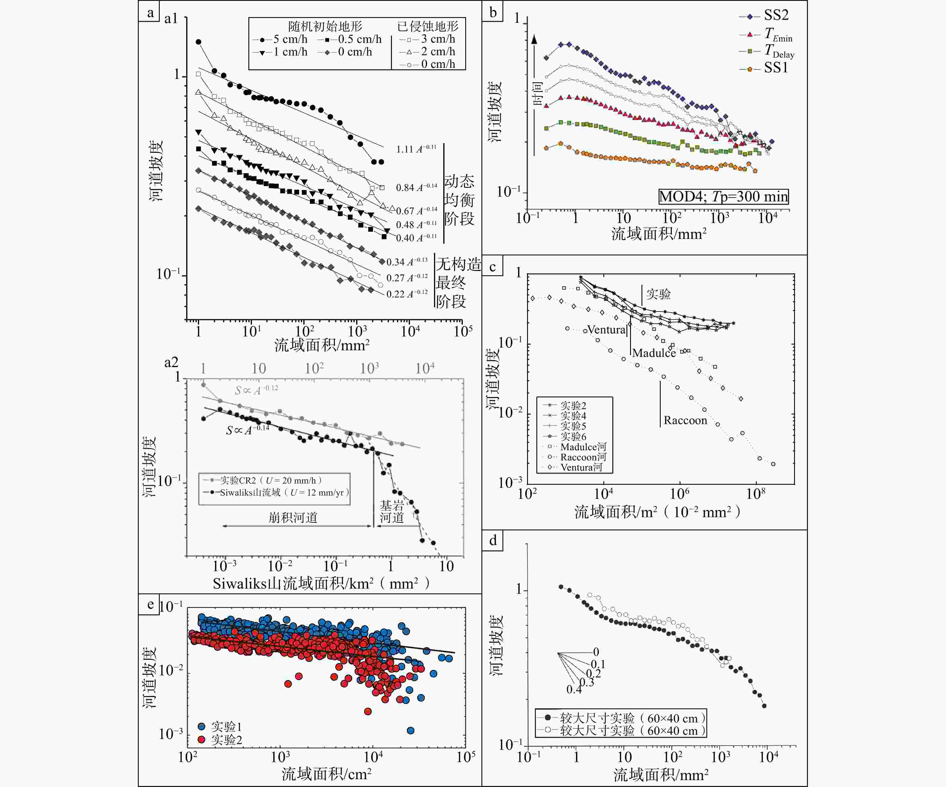
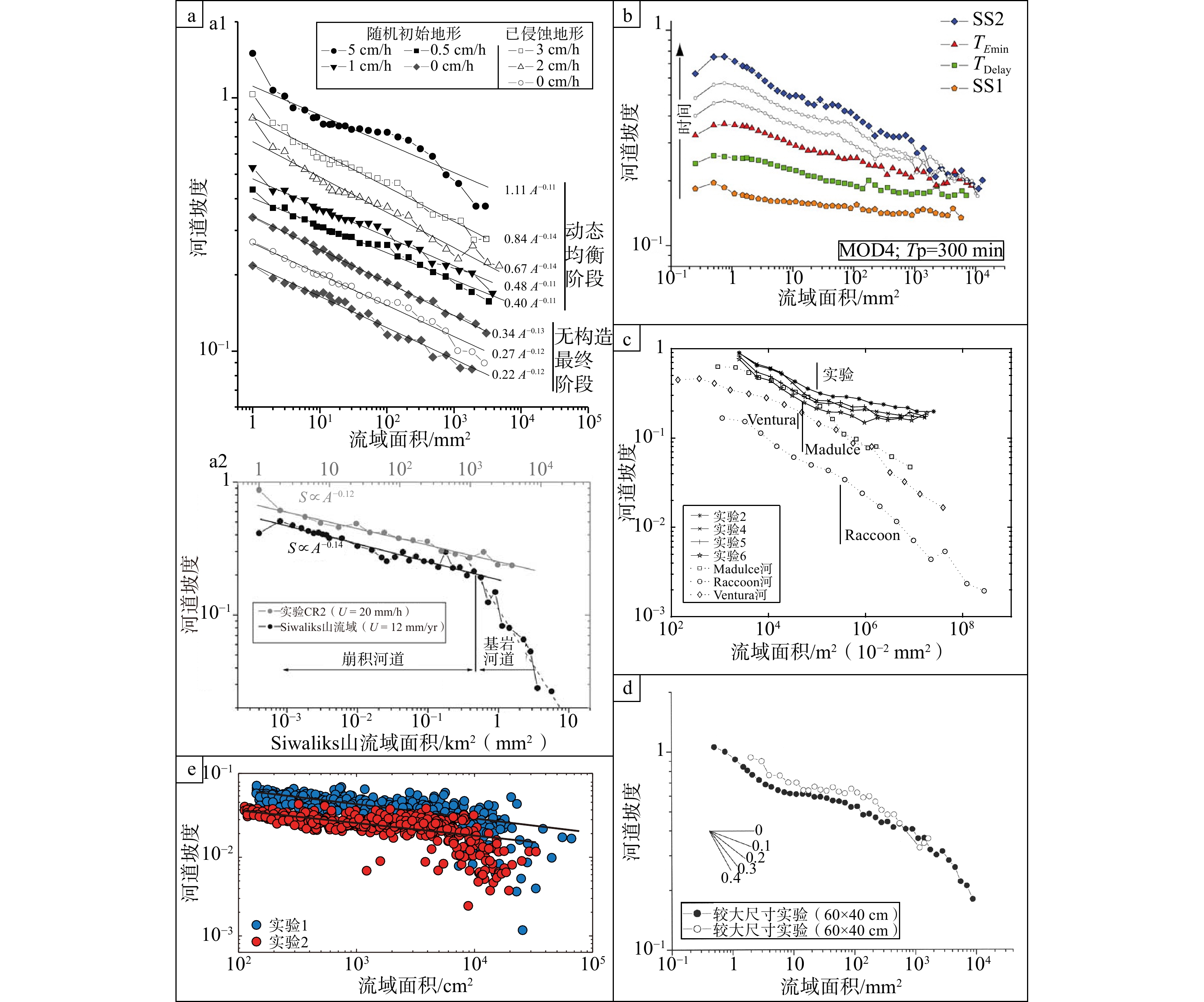
图 9 已有模拟研究中的坡度−面积关系
SS1—均衡状态1;SS2—均衡状态2;TEmin—达到Emin(非均衡状态下的最小侵蚀速率)所对应的时间;TDelay—地貌及侵蚀响应开始的时间;Tp—降水减少持续时间;U—抬升速率;A—流域面积;S—河道坡度a1—部分实验最终阶段的坡度−面积关系;a2—实验CR2与自然界Siwaliks山一个流域的坡度−面积的关系(据Lague et al.,2003修改);b—Moussirou and Bonnet(2018)中实验MOD4从均衡状态1演化到均衡状态2过程中的坡度−面积关系图(灰色点和符号表示过渡阶段);c—实验与自然界流域的坡度−面积关系图(据Niemann and Hasbargen,2005修改);d—相同抬升速率与降雨速率下达到稳态的2个尺寸不同实验的坡度−面积关系图(数据点为整个模型表面原始数据的对数分箱平均值;据Bonnet and Crave,2006修改);e—Guerit et al.(2018)给出的2个实验的河流坡度−面积关系(2个实验均呈现相同的m/n比值0.2,实验中使用的为“MatIV”饱水黏土)
Figure 9. Slope–area relationship in previous modeling studies
(a1) Slope–area relationship at the final stage of selected experiments; (a2) Slope–area relationship for experiment CR2 and a natural catchment from the Siwaliks Hills (modified from Lague et al., 2003); (b) Slope–area relationship for selected stages during the evolution of experiment MOD4 (solid symbols) and for intermediate stages (open symbols) between TEmin (Emin is the minimum erosion rate under non-steady-state conditions; TEmin is the time at which Emin is reached) and SS2 (SS stands for steady state; modified from Moussirou and Bonnet, 2018); (c) Slope–area relationship for experimental and natural catchments, where slopes are calculated using a parameter k = 0.2 (modified from Niemann and Hasbargen, 2005); (d) Slope–area relationship for two experiments of different sizes that reached steady state under the same uplift and rainfall rates. Data points are logarithmic bin averages of the raw data from the entire model surface (modified from Bonnet and Crave, 2006); (e) Slope–area relationship for two experiments. Both experiments yield the same m/n ratio of 0.2. Note that this study used “MatIV” water-saturated clay (modified from Guerit et al., 2018) SS1—steady state 1; SS2—steady state 2; TEmin—time corresponding to the minimum erosion rate (Emin) under non‑steady‑state conditions; TDelay—time when the geomorphic and erosion response begins; Tp—duration of precipitation decrease; U—uplift rate; A—drainage area; S—channel slope
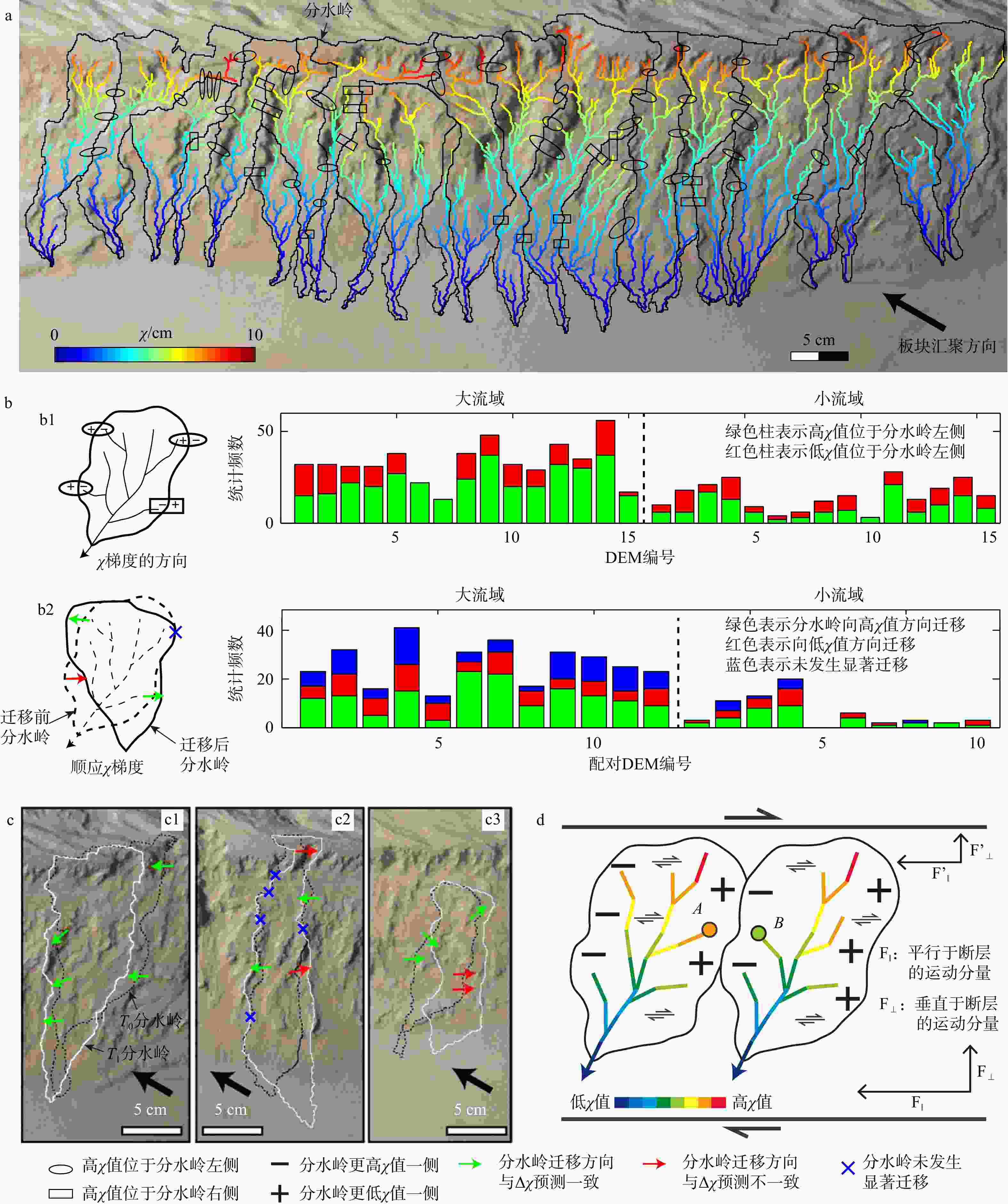
图 10 Guerit et al. (2018) 模拟研究中提取的河道χ值及其与分水岭迁移的关系
a—从实验数字高程模型(DEM)中提取的一幅典型χ值分布图;b—针对大流域与小流域的χ值与流域形态关系的统计分析(b1—T0时刻Δχ的方向;b2—为分水岭在T0至T1期间的迁移方向及其与χ和Δχ值的关系);c—大流域(c1和c2)与小流域(c3)在T0至T1期间的分水岭迁移实例;d—2条走滑断层边界斜向分布式应变作用影响下的流域顺时针旋转及χ值变化趋势
Figure 10. Channel χ values and their relationship with drainage divide migration in the modeling study of Guerit et al. (2018)
(a) A representative χ-map extracted from an experimental DEM; (b) Statistical analysis of the relationship between χ-values and basin morphology for large and small basins: (b1) Orientation of Δχ at time T0; (b2) The migration direction of the divide between T0 and T1 and its relationship with Δχ values; (c) Examples of divide migration from T0 to T1 for large basins (c1, c2) and small basins (c3); (d) Clockwise rotation of drainage basins and χ-value trends in response to distributed oblique strain bounded by two strike-slip faults
表 1 以往实验采用的实验材料和设置
Table 1. Experimental materials and setups used in previous studies
参考文献 实验材料 直径/μm 模型箱
长/cm×宽/cm降雨速率/
(mm/h)硅粉或黄土 Crave et al.,2000 硅粉 10 27×18 50 Bonnet and Crave,2003 硅粉 10~20 20×14 50~350 Lague et al.,2003 黄土 45 30×20 100 ± 15 Babault et al.,2005 硅粉 10 60×40 120 ± 5 Niemann and Hasbargen,2005 硅粉 (含1%高岭土) 45 近圆形
(面积6250 cm2)15~60 Bonnet,2009 硅粉 20 60×40 50~150(梯度) Tejedor et al.,2017 硅粉 25 50×50 45和225 Moussirou and Bonnet,2018 硅粉 10~20 60×40 60~160 Habousha et al.,2023 硅粉 75 90×50 65 ± 10 “MatIV”(括弧内分别为玻璃微珠、硅粉、PVC粉、碳粉的比例和粒径) Graveleau and Dominguez,2008 “MatIV”(40%、40%、18%、2%) 105 ± 5(88、43、147、172) 220×120 30 Strak et al.,2011 “MatIV”(40%、35%、23%、2%) 80 ± 5
(40~70、1~200、50、90~180)130×100 26 ± 4 Guerit et al.,2016,2018 “MatIV”(46%、30%、24%、额外~1%) 未说明(88、43、147、172) 260×140 0~50(梯度) 降雨量为范围且没有表明梯度降雨的,为多个实验采用不同降雨量  下载: 导出CSV
-
[1] BABAULT J, BONNET S, CRAVE A, et al., 2005. Influence of piedmont sedimentation on erosion dynamics of an uplifting landscape: an experimental approach[J]. Geology, 33(4): 301-304. doi: 10.1130/G21095.1 [2] BABAULT J, BONNET S, VAN DEN DRIESSCHE J, et al., 2007. High elevation of low-relief surfaces in mountain belts: does it equate to post-orogenic surface uplift?[J]. Terra Nova, 19(4): 272-277. doi: 10.1111/j.1365-3121.2007.00746.x [3] BIAN S, TAN X B, ZUZA A V, et al., 2025. How does the newly-formed drainage divide migrate after a river capture event?[J]. Earth and Planetary Science Letters, 651: 119165. doi: 10.1016/j.epsl.2024.119165 [4] BONNET S, CRAVE A, 2003. Landscape response to climate change: insights from experimental modeling and implications for tectonic versus climatic uplift of topography[J]. Geology, 31(2): 123-126. doi: 10.1130/0091-7613(2003)031<0123:LRTCCI>2.0.CO;2 [5] BONNET S, CRAVE A, 2006. Macroscale dynamics of experimental landscapes[M]//BUITER S J H, SCHREURS G. Analogue and numerical modelling of crustal-scale processes. London: Geological Society of London: 327-339. [6] BONNET S, 2009. Shrinking and splitting of drainage basins in orogenic landscapes from the migration of the main drainage divide[J]. Nature Geoscience, 2(12): 897-897. doi: 10.1038/ngeo666 [7] CHENG Y L, HE C Q, RAO G, et al., 2018. Geomorphological and structural characterization of the southern Weihe Graben, central China: implications for fault segmentation[J]. Tectonophysics, 722: 11-24. doi: 10.1016/j.tecto.2017.10.024 [8] CRAVE A, LAGUE D, DAVY P, et al., 2000. Analogue modelling of relief dynamics[J]. Physics and Chemistry of the Earth, Part A: Solid Earth and Geodesy, 25(6-7): 549-553. doi: 10.1016/S1464-1895(00)00084-3 [9] DODDS P S, ROTHMAN D H, 2000. Geometry of river networks. I. Scaling, fluctuations, and deviations[J]. Physical Review E, 63(1): 016115. [10] FORTE A M, WHIPPLE K X, 2018. Criteria and tools for determining drainage divide stability[J]. Earth and Planetary Science Letters, 493: 102-117. doi: 10.1016/j.epsl.2018.04.026 [11] GARDNER T W, 1983. Experimental study of knickpoint and longitudinal profile evolution in cohesive, homogeneous material[J]. GSA Bulletin, 94(5): 664-672. doi: 10.1130/0016-7606(1983)94<664:esokal>2.0.co;2 [12] GOREN L, FOX M, WILLETT S D, 2014. Tectonics from fluvial topography using formal linear inversion: theory and applications to the Inyo Mountains, California[J]. Journal of Geophysical Research: Earth Surface, 119(8): 1651-1681. doi: 10.1002/2014JF003079 [13] GRAVELEAU F, DOMINGUEZ S, 2008. Analogue modelling of the interaction between tectonics, erosion and sedimentation in foreland thrust belts[J]. Comptes Rendus Géoscience, 340(5): 324-333. doi: 10.1016/j.crte.2008.01.005 [14] GRAVELEAU F, HURTREZ J E, DOMINGUEZ S, et al., 2011. A new experimental material for modeling relief dynamics and interactions between tectonics and surface processes[J]. Tectonophysics, 513(1-4): 68-87. doi: 10.1016/j.tecto.2011.09.029 [15] GRAVELEAU F, MALAVIEILLE J, DOMINGUEZ S, 2012. Experimental modelling of orogenic wedges: a review[J]. Tectonophysics, 538-540: 1-66. [16] GRAVELEAU F, STRAK V, DOMINGUEZ S, et al., 2015. Experimental modelling of tectonics–erosion–sedimentation interactions in compressional, extensional, and strike–slip settings[J]. Geomorphology, 244: 146-168. doi: 10.1016/j.geomorph.2015.02.011 [17] GUERIT L, DOMINGUEZ S, MALAVIEILLE J, et al., 2016. Deformation of an experimental drainage network in oblique collision[J]. Tectonophysics, 693: 210-222. doi: 10.1016/j.tecto.2016.04.016 [18] GUERIT L, GOREN L, DOMINGUEZ S, et al., 2018. Landscape ‘stress’ and reorganization from χ-maps: insights from experimental drainage networks in oblique collision setting[J]. Earth Surface Processes and Landforms, 43(15): 3152-3163. doi: 10.1002/esp.4477 [19] HABOUSHA K, GOREN L, NATIV R, et al., 2023. Plan-form evolution of drainage basins in response to tectonic changes: insights from experimental and numerical landscapes[J]. Journal of Geophysical Research: Earth Surface, 128(3): e2022JF006876. doi: 10.1029/2022JF006876 [20] HACK J T, 1957. Studies of longitudinal stream profiles in Virginia and Maryland[R]. Washington: U. S. Geological Survey. [21] HE C Q, YANG C J, TUROWSKI J M, et al., 2021. Constraining tectonic uplift and advection from the main drainage divide of a mountain belt[J]. Nature Communications, 12(1): 544. doi: 10.1038/s41467-020-20748-2 [22] HORTON R E, 1932. Drainage-basin characteristics[J]. Eos, Transactions American Geophysical Union, 13(1): 350-361. [23] HOVIUS N, 1996. Regular spacing of drainage outlets from linear mountain belts[J]. Basin Research, 8(1): 29-44. doi: 10.1111/j.1365-2117.1996.tb00113.x [24] HOWARD A D, 1994. A detachment-limited model of drainage basin evolution[J]. Water Resources Research, 30(7): 2261-2285. doi: 10.1029/94WR00757 [25] HU X F, PAN B T, LI Q, 2014. Principles of the stream power erosion model and its latest progress in research[J]. Journal of Lanzhou University (Natural Sciences), 50(6): 824-831. (in Chinese with English abstract) [26] HURTREZ J E, SOL C, LUCAZEAU F, 1999. Effect of drainage area on hypsometry from an analysis of small-scale drainage basins in the siwalik hills (central nepal)[J]. Earth Surface Processes and Landforms, 24(9): 799-808. doi: 10.1002/(SICI)1096-9837(199908)24:9<799::AID-ESP12>3.0.CO;2-4 [27] KIRBY E, WHIPPLE K, 2001. Quantifying differential rock-uplift rates via stream profile analysis[J]. Geology, 29(5): 415-418. doi: 10.1130/0091-7613(2001)029<0415:QDRURV>2.0.CO;2 [28] LAGUE D, CRAVE A, DAVY P, 2003. Laboratory experiments simulating the geomorphic response to tectonic uplift[J]. Journal of Geophysical Research: Solid Earth, 108(B1): 2008. [29] LAVÉ J, AVOUAC J P, 2000. Active folding of fluvial terraces across the siwaliks hills, himalayas of central Nepal[J]. Journal of Geophysical Research: Solid Earth, 105(B3): 5735-5770. doi: 10.1029/1999JB900292 [30] LEOPOLD L B, WOLMAN M G, 1957. River channel patterns: braided, meandering, and straight[R]. Washington: U. S. Geological Survey: 50. [31] LI Q, LI Y Q, WANG X Y, et al., 2025. Drainage evolution in accretionary thrust systems as responses to tectono-climatic variability: insights from sandbox modelling[J]. Earth Surface Processes and Landforms, 50(7): e70099. doi: 10.1002/esp.70099 [32] LI X M, ZHANG H P, 2017. Transient fluvial landscape: features, processes and its implication for tectonic-climate interaction[J]. Quaternary Sciences, 37(2): 416-430. (in Chinese with English abstract) [33] LIU J, ZHANG J Y, GE Y K, et al., 2018. Tectonic geomorphology: an interdisciplinary study of the interaction among tectonic climatic and surface processes[J]. Chinese Science Bulletin, 63(30): 3070-3088. (in Chinese with English abstract) doi: 10.1360/n972018-00498 [34] LOGET N, VAN DEN DRIESSCHE J, 2009. Wave train model for knickpoint migration[J]. Geomorphology, 106(3-4): 376-382. doi: 10.1016/j.geomorph.2008.10.017 [35] MERRITTS D, VINCENT K R, 1989. Geomorphic response of coastal streams to low, intermediate, and high rates of uplift, medocino triple junction region, northern California[J]. GSA Bulletin, 101(11): 1373-1388. doi: 10.1130/0016-7606(1989)101<1373:grocst>2.3.co;2 [36] MONTGOMERY D R, DIETRICH W E, 1992. Channel initiation and the problem of landscape scale[J]. Science, 255(5046): 826-830. doi: 10.1126/science.255.5046.826 [37] MONTGOMERY D R, FOUFOULA-GEORGIOU E, 1993. Channel network source representation using digital elevation models[J]. Water Resources Research, 29(12): 3925-3934. doi: 10.1029/93WR02463 [38] MONTGOMERY D R, 2001. Slope distributions, threshold hillslopes, and steady-state topography[J]. American Journal of Science, 301(4-5): 432-454. doi: 10.2475/ajs.301.4-5.432 [39] MOUSSIROU B, BONNET S, 2018. Modulation of the erosion rate of an uplifting landscape by long-term climate change: an experimental investigation[J]. Geomorphology, 303: 456-466. doi: 10.1016/j.geomorph.2017.12.010 [40] NIEMANN J D, HASBARGEN L E, 2005. A comparison of experimental and natural drainage basin morphology across a range of scales[J]. Journal of Geophysical Research: Earth Surface, 110(F4): F04017. doi: 10.1029/2004jf000204 [41] PAOLA C, STRAUB K, MOHRIG D, et al., 2009. The “Unreasonable Effectiveness” of stratigraphic and geomorphic experiments[J]. Earth-Science Reviews, 97(1-4): 1-43. doi: 10.1016/j.earscirev.2009.05.003 [42] PECKHAM S D, 1995. New results for self-similar trees with applications to river networks[J]. Water Resources Research, 31(4): 1023-1029. doi: 10.1029/94WR03155 [43] PURDIE H, BROOK M, 2006. Drainage spacing regularity on a fault-block: a case study from the eastern ruahine range[J]. New Zealand Geographer, 62(2): 97-104. doi: 10.1111/j.1745-7939.2006.00034.x [44] RIGON R, RODRIGUEZ-ITURBE I, MARITAN A, et al., 1996. On Hack's law[J]. Water Resources Research, 32(11): 3367-3374. doi: 10.1029/96WR02397 [45] SCHUMM S A, 1956. Evolution of drainage systems and slopes in badlands at Perth Amboy, New Jersey[J]. GSA Bulletin, 67(5): 597-646. doi: 10.1130/0016-7606(1956)67[597:eodsas]2.0.co;2 [46] SHAO C J, LI Y, ZHAO G H, et al., 2015. Tectonic geomorphology analysis of piedmont rivers in the southern section of Longmenshan based on hypsometric integral[J]. Geoscience, 29(4): 727-737. (in Chinese with English abstract) [47] SMART J S, SURKAN A J, 1967. The relation between mainstream length and area in drainage basins[J]. Water Resources Research, 3(4): 963-974. doi: 10.1029/WR003i004p00963 [48] SNYDER N P, WHIPPLE K X, TUCKER G E, et al., 2000. Landscape response to tectonic forcing: digital elevation model analysis of stream profiles in the mendocino triple junction region, northern California[J]. GSA Bulletin, 112(8): 1250-1263. doi: 10.1130/0016-7606(2000)112<1250:LRTTFD>2.0.CO;2 [49] STRAHLER A N, 1952. Hypsometric (area-altitude) analysis of erosional topography[J]. GSA Bulletin, 63(11): 1117-1142. doi: 10.1130/0016-7606(1952)63[1117:haaoet]2.0.co;2 [50] STRAK V, DOMINGUEZ S, PETIT C, et al., 2011. Interaction between normal fault slip and erosion on relief evolution: insights from experimental modelling[J]. Tectonophysics, 513(1-4): 1-19. doi: 10.1016/j.tecto.2011.10.005 [51] TALLING P J, STEWART M D, STARK C P, et al., 1997. Regular spacing of drainage outlets from linear fault blocks[J]. Basin Research, 9(4): 275-302. doi: 10.1046/j.1365-2117.1997.00048.x [52] TEJEDOR A, SINGH A, ZALIAPIN I, et al., 2017. Scale-dependent erosional patterns in steady-state and transient-state landscapes[J]. Science Advances, 3(9): e1701683. doi: 10.1126/sciadv.1701683 [53] TUCKER G E, WHIPPLE K X, 2002. Topographic outcomes predicted by stream erosion models: sensitivity analysis and intermodel comparison[J]. Journal of Geophysical Research: Solid Earth, 107(B9): 2179. doi: 10.1029/2001jb000162 [54] VIAPLANA-MUZAS M, BABAULT J, DOMINGUEZ S, et al., 2015. Drainage network evolution and patterns of sedimentation in an experimental wedge[J]. Tectonophysics, 664: 109-124. doi: 10.1016/j.tecto.2015.09.007 [55] WALKER F, ALLEN M B, 2012. Offset rivers, drainage spacing and the record of strike-slip faulting: the Kuh Banan Fault, Iran[J]. Tectonophysics, 530-531: 251-263. [56] WANG Y Z, ZHANG H P, ZHENG D W, et al., 2016. Stream-power incision model and its implications: discussion on the urgency of studying bedrock channel across the Tibetan Plateau[J]. Quaternary Sciences, 36(4): 884-897. (in Chinese with English abstract) [57] WHIPPLE K X, KIRBY E, BROCKLEHURST S H, 1999. Geomorphic limits to climate-induced increases in topographic relief[J]. Nature, 401(6748): 39-43. doi: 10.1038/43375 [58] WHIPPLE K X, TUCKER G E, 1999. Dynamics of the stream-power river incision model: implications for height limits of mountain ranges, landscape response timescales, and research needs[J]. Journal of Geophysical Research: Solid Earth, 104(B8): 17661-17674. doi: 10.1029/1999JB900120 [59] WHIPPLE K X, 2001. Fluvial landscape response time: how plausible is steady-state denudation?[J]. American Journal of Science, 301(4-5): 313-325. doi: 10.2475/ajs.301.4-5.313 [60] WHIPPLE K X, TUCKER G E, 2002. Implications of sediment-flux-dependent river incision models for landscape evolution[J]. Journal of Geophysical Research: Solid Earth, 107(B2): 2039. [61] WHIPPLE K X, FORTE A M, DIBIASE R A, et al., 2017. Timescales of landscape response to divide migration and drainage capture: implications for the role of divide mobility in landscape evolution[J]. Journal of Geophysical Research: Earth Surface, 122(1): 248-273. doi: 10.1002/2016JF003973 [62] WHITTAKER A C, BOULTON S J, 2012. Tectonic and climatic controls on knickpoint retreat rates and landscape response times[J]. Journal of Geophysical Research: Earth Surface, 117(F2): F02024. [63] WILLETT S D, HOVIUS N, BRANDON M T, et al. , 2006. Tectonics, climate, and landscape evolution[M]. Boulder: Geological Society of America. [64] WILLETT S D, MCCOY S W, PERRON J T, et al., 2014. Dynamic reorganization of river basins[J]. Science, 343(6175): 1248765. doi: 10.1126/science.1248765 [65] WILLGOOSE G, HANCOCK G, 1998. Revisiting the hypsometric curve as an indicator of form and process in transport-limited catchment[J]. Earth Surface Processes and Landforms, 23(7): 611-623. doi: 10.1002/(SICI)1096-9837(199807)23:7<611::AID-ESP872>3.0.CO;2-Y [66] XU W, LIU Z C, YUAN Z D, et al., 2017. River geomorphic parameters of the Huashan Piedmont and their tectonic implications[J]. Seismology and Geology, 39(6): 1316-1335. (in Chinese with English abstract) [67] YAN B, JIA D, 2017. Systematic offset of bedrock channels along active strike-slip faults on the eastern Tibetan Plateau[J]. Seismology and Geology, 39(6): 1127-1142. (in Chinese with English abstract) [68] YAN B, JIA D, WANG M M, 2023. Drainage development on the northern Tibetan Plateau controlled by the altyn tagh fault: insights from analogue modelling[J]. Earth Surface Processes and Landforms, 48(10): 2005-2022. doi: 10.1002/esp.5600 [69] YANG R, WILLETT S D, GOREN L, 2015. In situ low-relief landscape formation as a result of river network disruption[J]. Nature, 520(7548): 526-529. doi: 10.1038/nature14354 [70] ZHANG H P, ZHANG P Z, WU Q L, et al., 2008. Characteristics of the Huanghe River longitudinal profiles around Xunhua-Guide area (NE Tibet) and their tectonic significance[J]. Quaternary Sciences, 28(2): 299-309. (in Chinese with English abstract) [71] ZHOU C, TAN X B, LIU Y D, et al., 2022. A cross-divide contrast index (C) for assessing controls on the main drainage divide stability of a mountain belt[J]. Geomorphology, 398: 108071. doi: 10.1016/j.geomorph.2021.108071 [72] 胡小飞, 潘保田, 李琼, 2014. 基岩河道水力侵蚀模型原理及其最新研究进展[J]. 兰州大学学报(自然科学版), 50(6): 824-831. [73] 李雪梅, 张会平, 2017. 河流瞬时地貌: 特征、过程及其构造-气候相互作用内涵[J]. 第四纪研究, 37(2): 416-430. [74] 刘静, 张金玉, 葛玉魁, 等, 2018. 构造地貌学: 构造-气候-地表过程相互作用的交叉研究[J]. 科学通报, 63(30): 3070-3088. [75] 邵崇建, 李勇, 赵国华, 等, 2015. 基于面积-高程积分对龙门山南段山前河流的构造地貌研究[J]. 现代地质, 29(4): 727-737. [76] 王一舟, 张会平, 郑德文, 等, 2016. 基岩河道河流水力侵蚀模型及其应用: 兼论青藏高原基岩河道研究的迫切性[J]. 第四纪研究, 36(4): 884-897. [77] 徐伟, 刘志成, 袁兆德, 等, 2017. 华山山前河流地貌参数及其构造意义[J]. 地震地质, 39(6): 1316-1335. doi: 10.3969/j.issn.0253-4967.2017.06.015 [78] 闫兵, 贾东, 2017. 沿走滑活动断层的基岩河道系统位错: 以青藏高原东部为例[J]. 地震地质, 39(6): 1127-1142. doi: 10.3969/j.issn.0253-4967.2017.06.003 [79] 张会平, 张培震, 吴庆龙, 等, 2008. 循化-贵德地区黄河水系河流纵剖面形态特征及其构造意义[J]. 第四纪研究, 28(2): 299-309. doi: 10.3321/j.issn:1001-7410.2008.02.012 -

 下载:
下载:






计量
- 文章访问数: 461
- HTML全文浏览量: 121
- PDF下载量: 151
- 被引次数: 0
