


Geomorphic features and tectonic responses in the Upper Yalong River basin
-
摘要: 雅砻江上游地处巴颜喀拉块体东南缘,水系发达,区内北西向的大型活动断裂贯穿流域盆地。当前研究多聚焦于其断裂活动性、古地震事件及地震危险性评估,关于流域地貌特征及其构造变形响应方面的研究相对薄弱。文章基于30 m分辨率Copernicus数字高程模型(DEM)提取了雅砻江上游98个子流域,计算各子流域的面积−高程积分(HI)、流域形状指数(BS)、流域盆地不对称度(AF)、流域伸长比(Re)及标准化河流梯度指数平均值(SLKavg),通过量化与分级,集成为综合指标——相对构造活动强度(Iat),结合归一化河道陡峭指数(ksn)、河流裂点揭示流域地貌特征的空间分异规律,进而探讨构造活动与地貌演化之间的耦合关系。研究结果表明,雅砻江上游流域HI值介于0.09~0.63,部分子流域处于发育幼年期,流域几何形态呈现明显不对称,水系、冲沟与冲洪积扇发生左旋位错,SLKavg、ksn揭示若干子流域抬升强烈,河道纵向坡度变化显著;Iat表明构造活动性在空间上呈现强弱相间、弱域连通的分异格局,低值Iat子流域沿断裂呈条带状分布;五道梁−长沙贡玛断裂全新世活动段南北端Iat值较低,中段Iat值较高,可能与断裂分段局部的构造变形差异有关;甘孜−玉树断裂经过子流域Iat值也较低,对应块体边界的强活动性;各地貌指数对Iat影响强度大小依次为Re、HI、AF、SLKavg、BS。构造活动、地貌特征与地震活动在雅砻江上游地区表现出显著的一致性,表明构造动力对流域地貌的发育与演化具有主导控制作用。
-
关键词:
- 雅砻江上游 /
- 巴颜喀拉块体 /
- 五道梁−长沙贡玛断裂 /
- 地貌指数 /
- 相对构造活动性
Abstract:Objective The Upper Yalong River basin, situated on the southeastern margin of the Bayan Har block, is characterized by a well-developed river system. Large-scale NW-trending active faults traverse this drainage basin, where tectonic activity constrains regional fluvial geomorphic development and evolution. Current research has predominantly focused on fault activity, paleoseismic events, and seismic hazard assessment, whereas studies addressing basin-scale geomorphic characteristics and their response to tectonic deformation remain relatively limited. Methods Based on a 30-meter-resolution Copernicus Digital Elevation Model (DEM), 98 sub-basins were identified within the Upper Yalong River basin. Five geomorphic indices were calculated for each sub-basin: hypsometric integral (HI), basin shape index (BS), asymmetry factor (AF), elongation ratio (Re), and mean normalized stream gradient index (SLKavg). These indices were quantified, classified, and integrated into a composite indicator—the relative strength of tectonic activity (Iat). Furthermore, the normalized channel steepness index (ksn) and knickpoints were incorporated to reveal the spatial differentiation of fluvial geomorphic characteristics and to explore the coupling relationship between tectonic activity and landscape evolution. Results In the Upper Yalong River basin, HI values range from 0.09 to 0.63. Some sub-basins are in an early stage of development and exhibit significant asymmetry. Left-lateral offsets of waterways, gullies, and alluvial fans are observed. SLKavg and ksn indicate strong tectonic uplift in most basins, accompanied by significant longitudinal variations in channel slope. Spatially, the Iat displays a pattern of alternating high and low values, with interconnected low-activity zones. Basins with low Iat values are distributed in linear belts along fault zones. Along the Wudaoliang–Changshagongma fault, which crosses the upper basin, Iat values are lower in the northern and southern Holocene-active segments. In contrast, the middle segment intersecting the Changshagongma Basin shows higher Iat values, possibly related to localized variations in tectonic deformation along fault segments. Basins traversed by the Ganzi–Yushu fault also exhibit relatively low Iat values, corresponding to strong activity at the block boundary. The geomorphic indices affect Iat in the order: Re > HI > AF > SLKavg > BS. Conclusions The strong consistency among tectonic activity, geomorphic features, and seismic activity in the study area directly reflects the role of tectonic processes in shaping the regional landscape pattern. The spatial differentiation of Iat and geomorphic indices effectively captures differential tectonic uplift and deformation along fault zones, providing clear geomorphic evidence of ongoing tectonic dynamics on the southeastern margin of the Bayan Har block. -
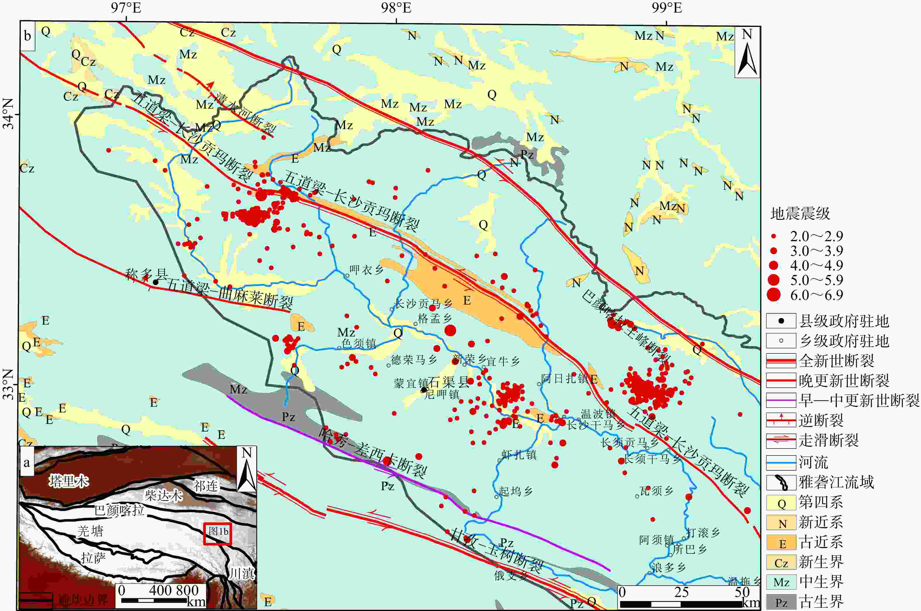
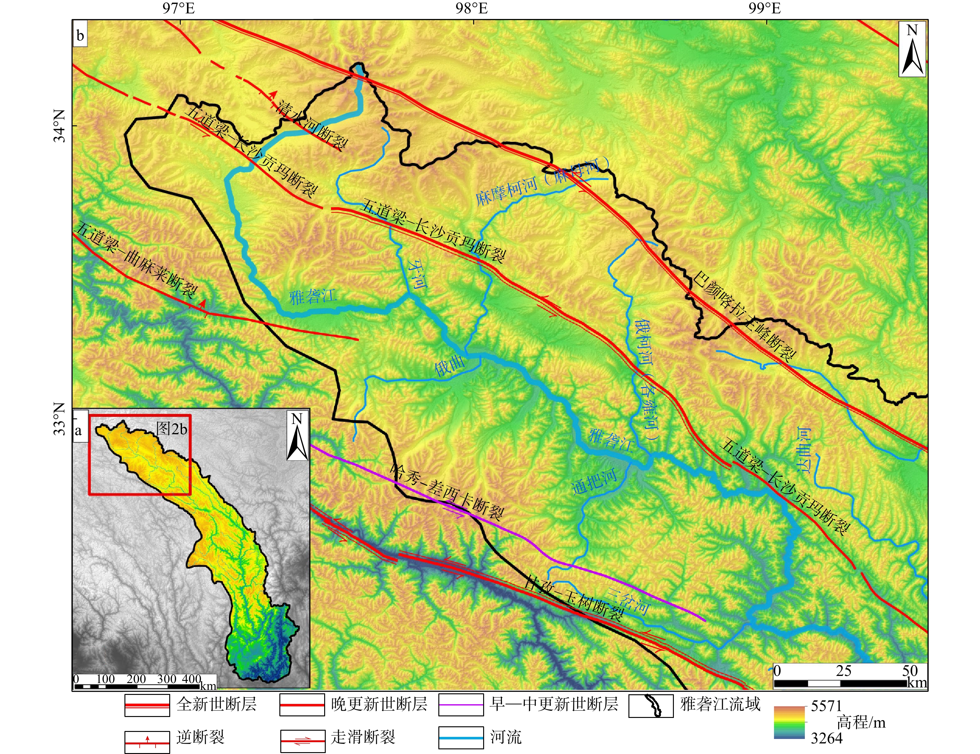
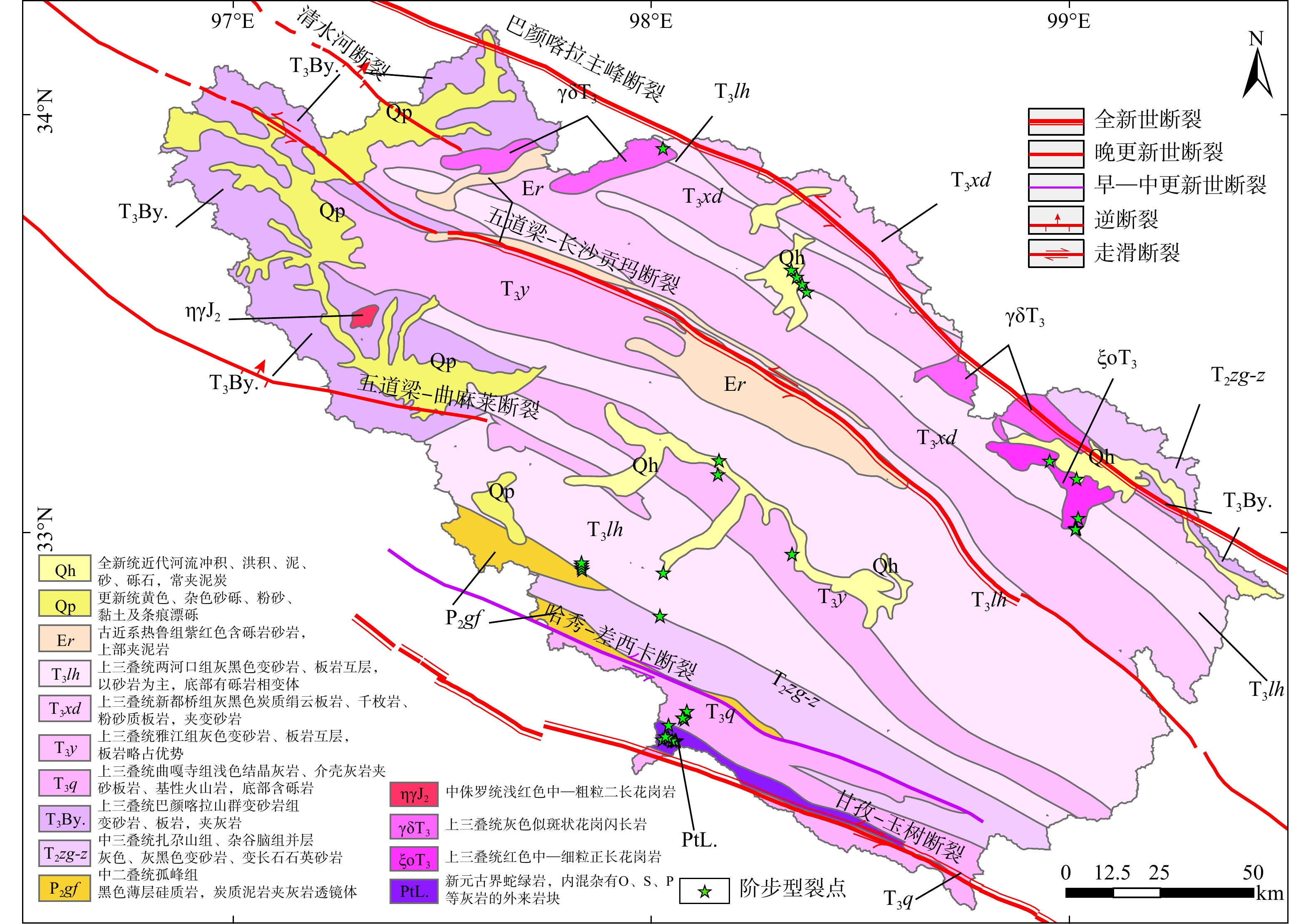
图 1 雅砻江上游地质构造简图
a—雅砻江上游构造背景;b—雅砻江上游构造概况
Figure 1. Simplified geological structural map of the Upper Yalong River basin
(a) Regional tectonic overview of the Upper Yalong River basin; (b) Stratigraphic distribution and tectonic overview of the Upper Yalong River basin
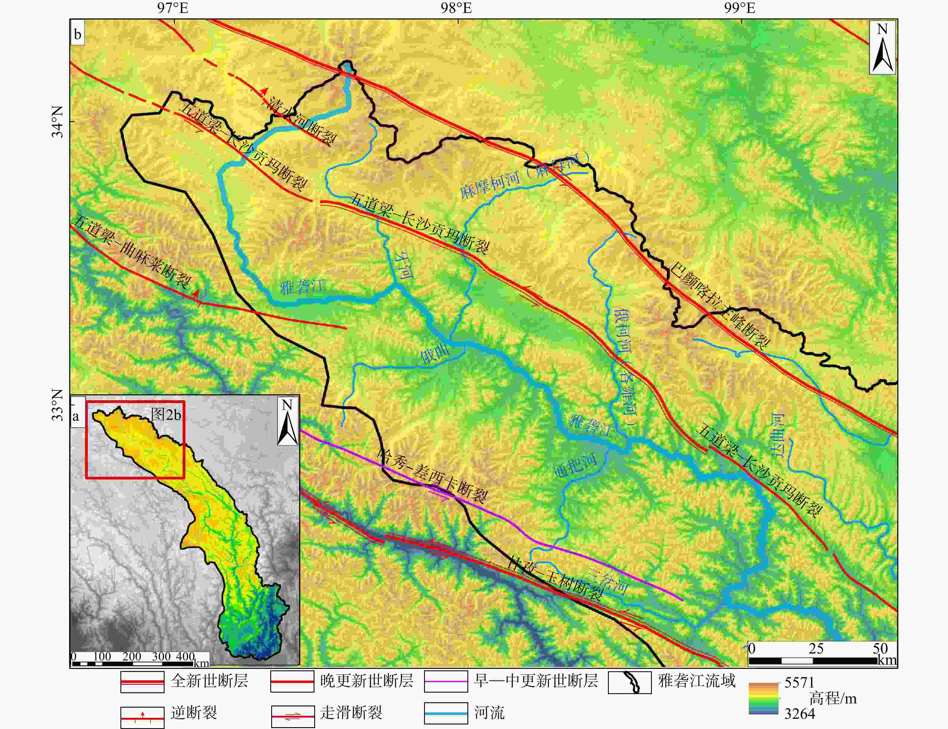
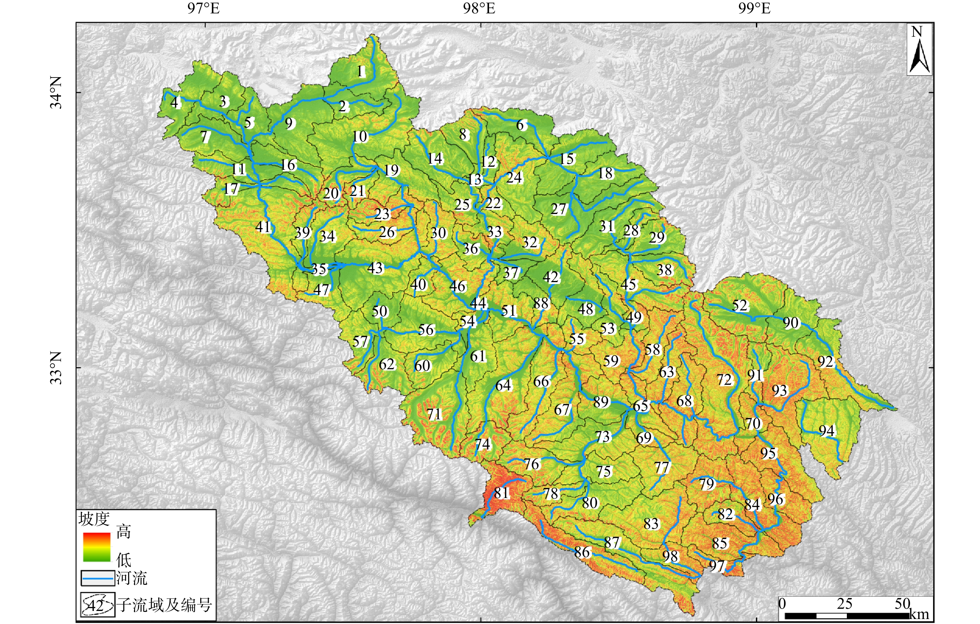
图 2 雅砻江上游DEM特征
a—雅砻江上游流域地理位置;b—雅砻江上游流域DEM
Figure 2. DEM of the Upper Yalong River basin
(a) Location of the Upper Yalong River basin; (b) Digital elevation model (DEM) of the Upper Yalong River basin
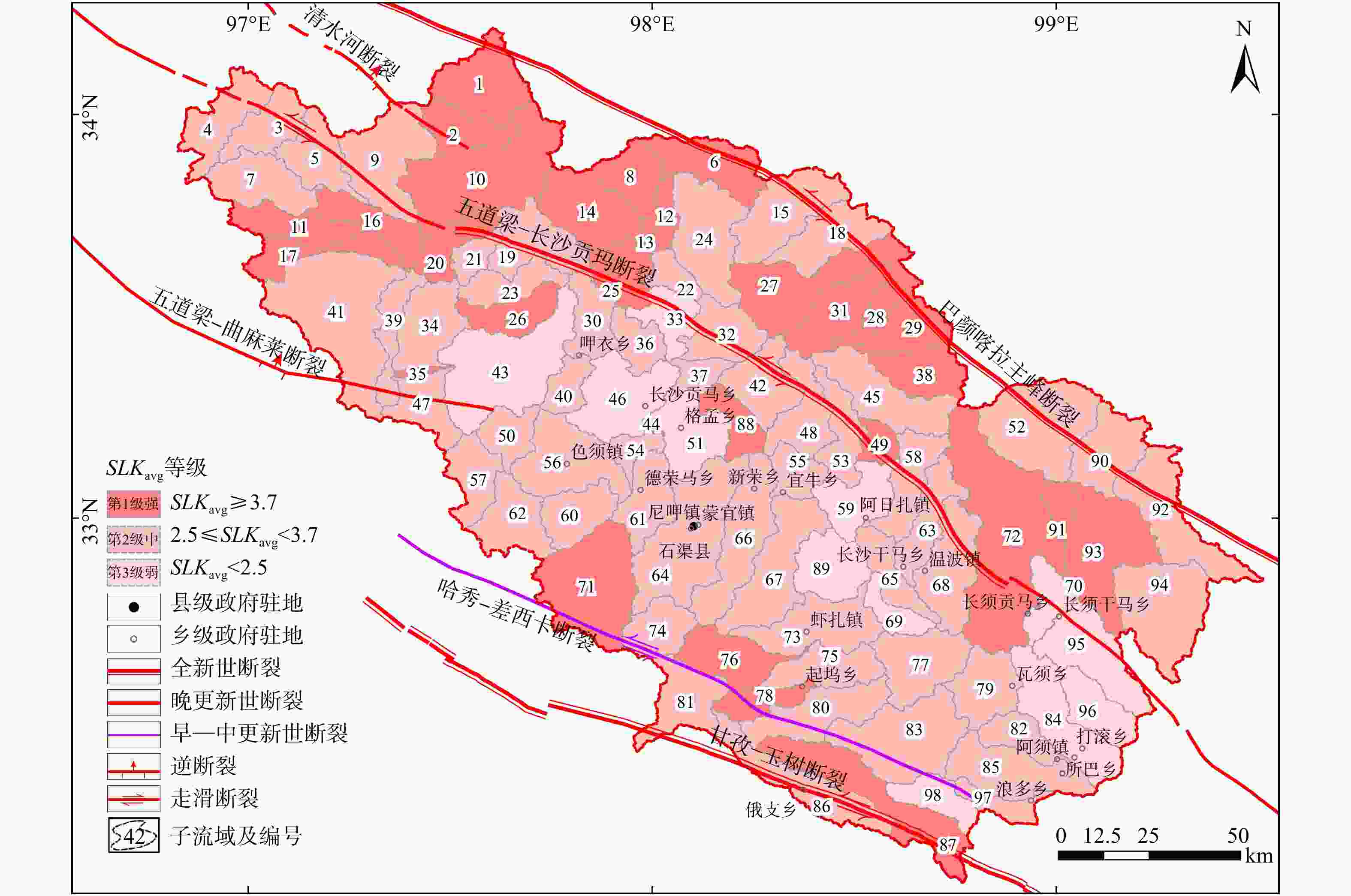
图 8 标准化河流梯度指数平均值(SLKavg)分布图
Figure 8. Distribution of the mean normalized stream length gradient (SLKavg)
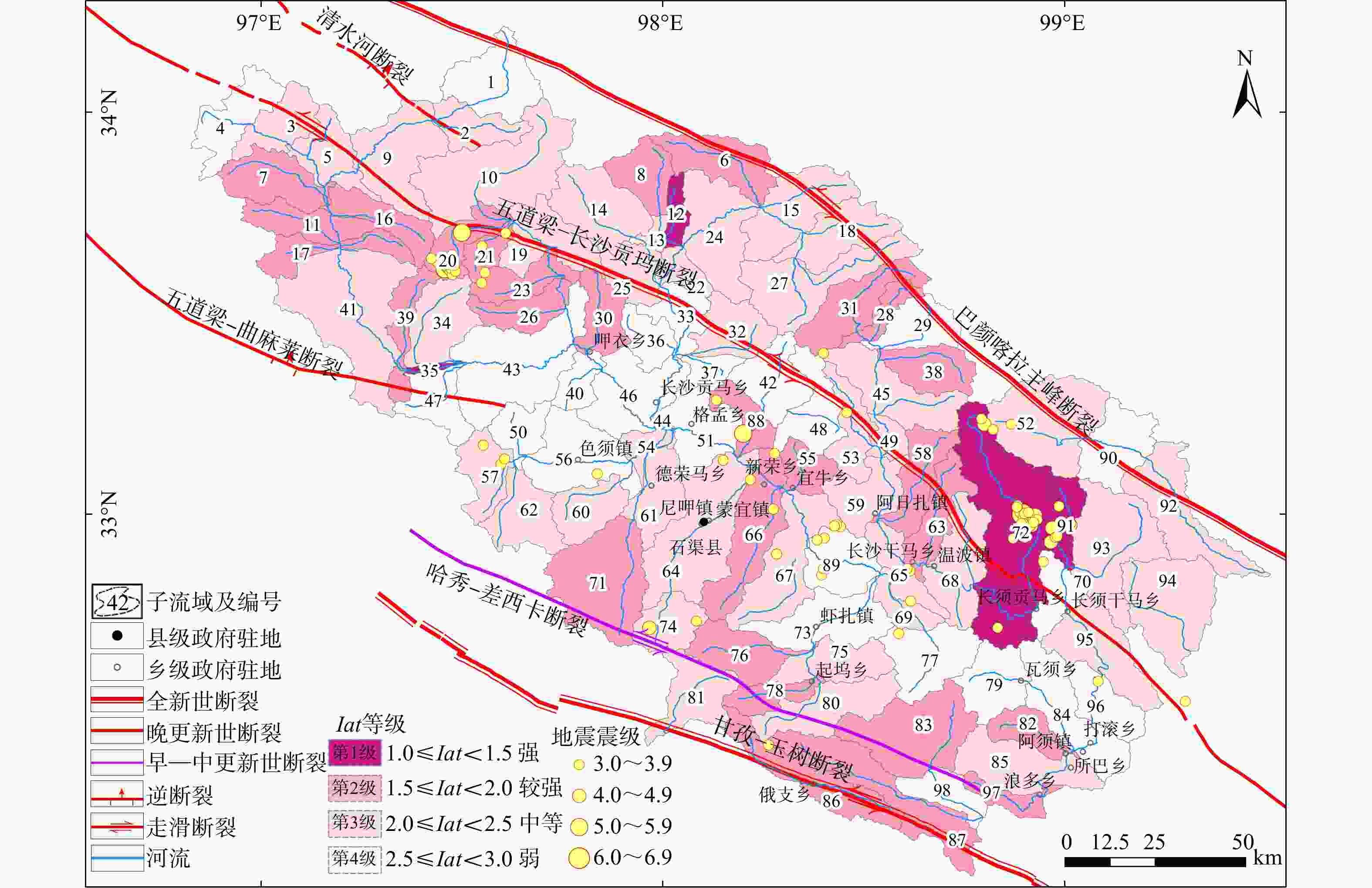
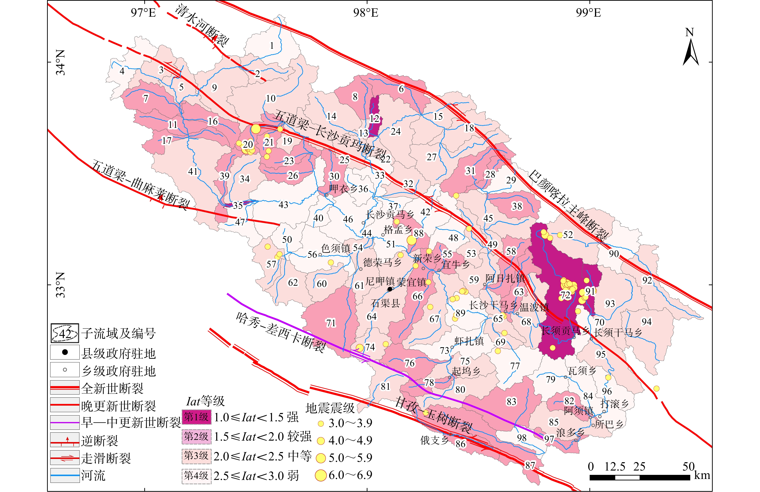
图 9 相对构造活动强度(Iat)分布图
Figure 9. Distribution of relative tectonic activity classes (Iat)
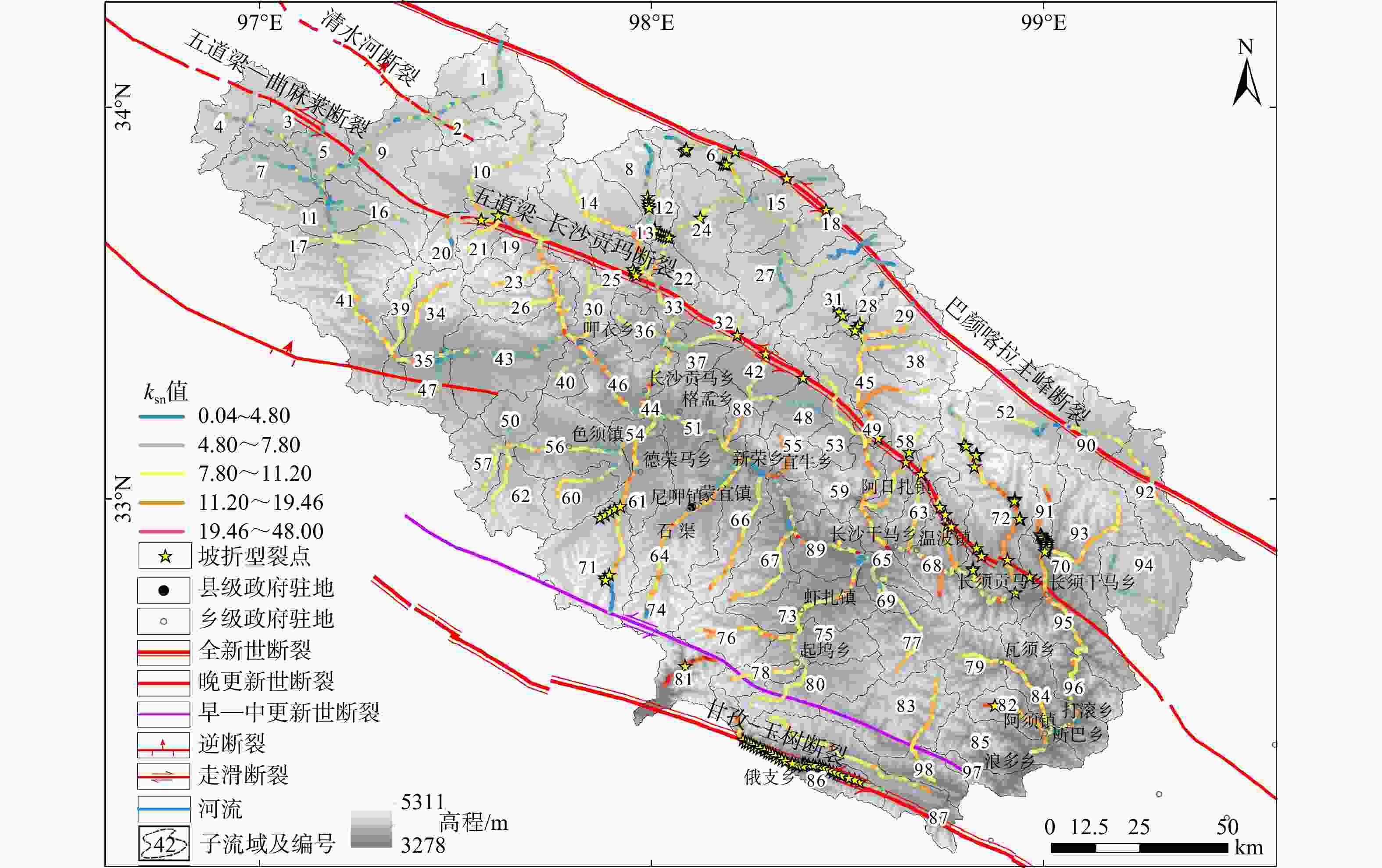
图 10 归一化河道陡峭指数 (ksn)分布图
Figure 10. Distribution of the normalized channel steepness index(ksn)
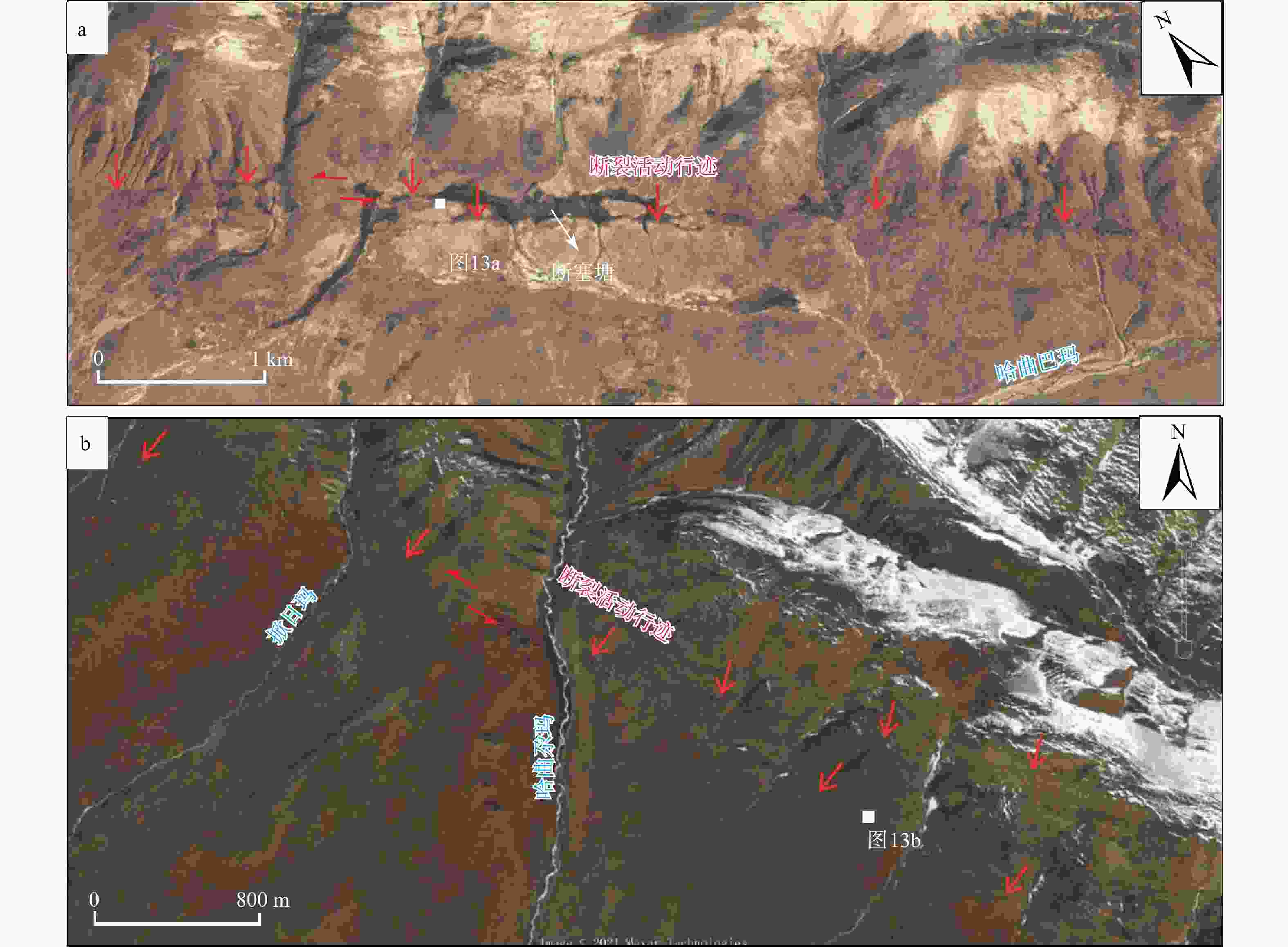
图 12 五道梁−长沙贡玛断裂活动行迹(据梁明剑等,2022修改)
a—32号子流域断裂构造地貌;b—42号子流域断裂构造地貌
Figure 12. Active traces of the Wudaoliang–Changshagongma fault (modified after Liang et al., 2022)
(a) Fault-controlled tectonic geomorphology of No. 32 sub-basin; (b) Fault-controlled tectonic geomorphology of No. 42 sub-basin
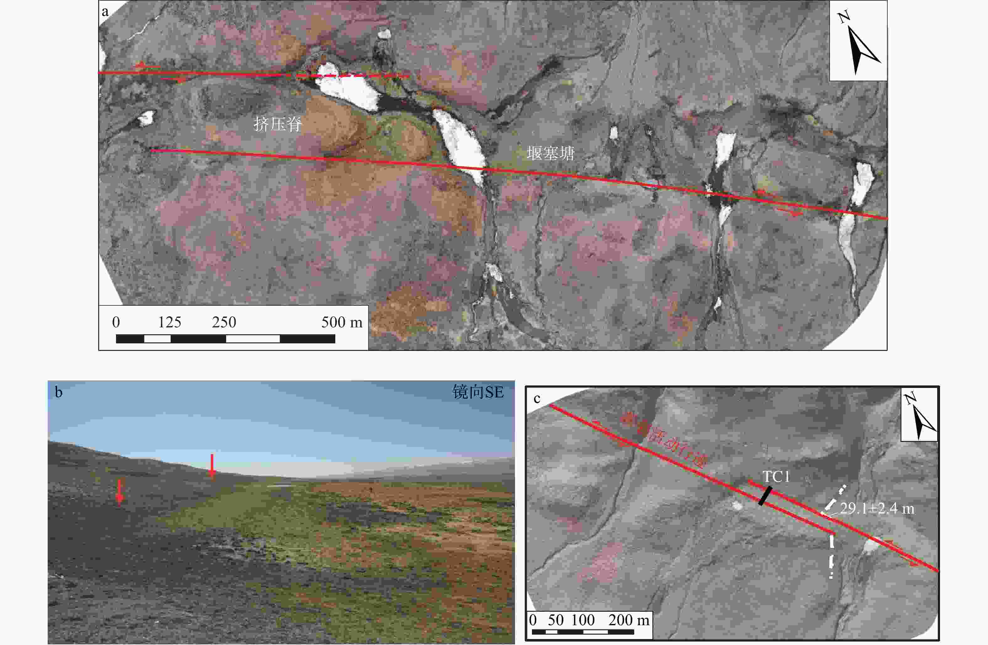
图 13 典型构造地貌特征(具体位置见图12;据梁明剑等,2022修改)
a—哈曲巴玛沟口西山前洪积扇的挤压脊与堰塞塘;b—哈曲尕玛沟口东山前洪积扇断层陡坎与槽谷;c—哈曲尕玛沟口东山前洪积扇左旋错断约29.1±2.4 m
Figure 13. Typical tectonic geomorphic features (see Fig. 12 for locations; modified after Liang et al., 2022)
(a) Compressional ridge and sag pond developed on the alluvial fan near the mouth of the Haqubama river; (b) Fault scarp and trough on the eastern piedmont alluvial fan at the mouth of the Haqugama gully; (c) The piedmont alluvial fan east of the mouth of the Haqugama river has been left‑laterally offset by approximately 29.1±2.4 m
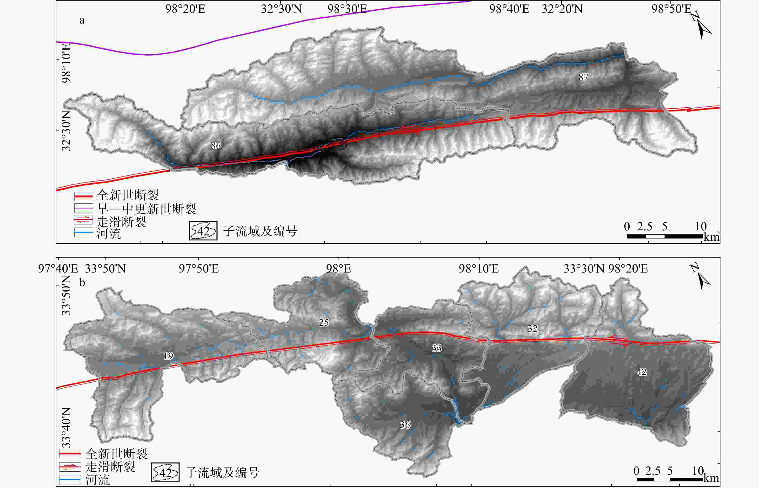
图 14 断裂性质影响水系结构
a—甘孜−玉树断裂影响水系结构;b—五道梁−长沙贡玛断裂影响水系结构
Figure 14. Influence of fault properties on drainage structure
(a) Drainage structure controlled by the Ganzi–Yushu fault; (b) Drainage structure controlled by the Wudaoliang–Changshagongma fault
表 1 地貌指数分级示意表
Table 1. Classification of geomorphic indices
地貌指数分级及构造活动性程度 地貌指数分类方法 最终选取分类 El Hamdouni et al.,2008 Dehbozorgi et al.,2010 孙林龙等,2024 王阳等,2024 HI 第1级(强) HI>0.5 HI$\geqslant $0.5 HI>0.5 HI$\geqslant $0.46 HI>0.5 第2级(中) 0.4$\leqslant $HI$\leqslant $0.5 0.4$\leqslant $HI<0.5 0.4$\leqslant $HI$\leqslant $0.5 0.37$\leqslant $HI<0.46 0.4$\leqslant $HI$\leqslant $0.5 第3级(弱) HI<0.4 HI<0.4 HI<0.4 HI<0.37 HI<0.4 BS 第1级(强) BS$ \geqslant 4.0 $ BS$ \geqslant 4.0 $ BS>2.3 − BS>2.3 第2级(中) 3.0<BS<4.0 3.0<BS<4.0 1.5$\leqslant $BS$\leqslant $2.3 − 1.5$\leqslant $BS$\leqslant $2.3 第3级(弱) BS$ \leqslant 3.0 $ BS$ \leqslant 3.0 $ BS<1.5 − BS<1.5 $ AF $ 第1级(强) $ \left| AF-50\right| \geqslant 15 $ $ \left| AF-50\right| \geqslant 15 $ $ \left| AF-50\right| \geqslant 15 $ $ \left| AF-50\right| \geqslant 15 $ $ \left| AF—50\right| \geqslant 15 $ 第2级(中) $ 7 \leqslant \left| AF-50\right| <15 $ $ 7 \leqslant \left| AF-50\right| <15 $ $ 7 \leqslant \left| AF-50\right| <15 $ $ 7 \leqslant \left| AF-50\right| <15 $ $ 7 \leqslant \left| AF—50\right| <15 $ 第3级(弱) $ \left| AF-50\right| <7 $ $ \left| AF-50\right| <7 $ $ \left| AF-50\right| <7 $ $ \left| AF-50\right| <7 $ $ \left| AF—50\right| <7 $ $ Re $ 第1级(强) − − − $ Re<0.5 $ $ Re<0.5 $ 第2级(中) − − − $ 0.5 \leqslant Re<0.75 $ $ 0.5 \leqslant Re<0.75 $ 第3级(弱) − − − $ 0.75 \leqslant Re $ $ 0.75 \leqslant Re $ $ {SLK}_{\text{avg}} $ 第1级(强) − − $ {SLK}_{\text{avg}}\geqslant $3.7 − $ {SLK}_{\text{avg}}\geqslant $3.7 第2级(中) − − $ 2.5 \leqslant {SLK}_{\text{avg}}<3.7 $ − $ 2.5 \leqslant {SLK}_{\text{avg}}<3.7 $ 第3级(弱) − − $ {SLK}_{\text{avg}}<2.5 $ − $ {SLK}_{\text{avg}}<2.5 $ $ Iat $ 第1级(强) $ 1.0<Iat<1.5 $ $ 1.0 \leqslant Iat<1.5 $ $ 1.0 \leqslant Iat<1.5 $ $ 1.0 \leqslant Iat<1.5 $ $ 1.0 \leqslant Iat<1.5 $ 第2级(较强) $ 1.5<Iat<2.0 $ $ 1.5 \leqslant Iat<2.0 $ $ 1.5 \leqslant Iat<2.0 $ $ 1.5 \leqslant Iat<2.0 $ $ 1.5 \leqslant Iat<2.0 $ 第3级(中等) $ 2.0<Iat<2.5 $ $ 2.0 \leqslant Iat<2.5 $ $ 2.0 \leqslant Iat<2.5 $ $ 2.0 \leqslant Iat<2.5 $ $ 2.0 \leqslant Iat<2.5 $ 第4级(弱) $ 2.5<Iat $ $ 2.5 \leqslant Iat<3.0 $ $ 2.5 \leqslant Iat<3.0 $ $ 2.5 \leqslant Iat<3.0 $ $ 2.5 \leqslant Iat<3.0 $ 注:HI—面积−高程积分;BS—流域形状指数;AF—流域盆地不对称度;Re—流域伸长比;${SLK}_{\text{avg}} $—标准化河流梯度指数平均值;Iat—相对构造活动强度  下载: 导出CSV
-
[1] BHAT M A, DAR T, BALI B S, 2020. Morphotectonic analysis of Aripal Basin in the north-western Himalayas (India): an evaluation of tectonics derived from geomorphic indices[J]. Quaternary International, 568: 103-115. doi: 10.1016/j.quaint.2020.10.032 [2] CAO P J, CHENG S Y, LIN H X, et al., 2021. DEM in quantitative analysis of structural geomorphology: application and prospect[J]. Journal of Geomechanics, 27(6): 949-962. (in Chinese with English abstract) [3] DAI Z L, SHEN Y G, LI A B, 2024. Automatic extraction of the geomorphic indices[DB/OL]. Zenodo [2026-09-16] [4] DEHBOZORGI M, POURKERMANI M, ARIAN M, et al., 2010. Quantitative analysis of relative tectonic activity in the Sarvestan area, central Zagros, Iran[J]. Geomorphology, 121(3-4): 329-341. doi: 10.1016/j.geomorph.2010.05.002 [5] EL HAMDOUNI R, IRIGARAY C, FERNÁNDEZ T, et al., 2008. Assessment of relative active tectonics, southwest border of the Sierra Nevada (southern Spain)[J]. Geomorphology, 96(1-2): 150-173. doi: 10.1016/j.geomorph.2007.08.004 [6] FIGUEROA A M, KNOTT J R, 2010. Tectonic geomorphology of the southern Sierra Nevada Mountains (California): evidence for uplift and basin formation[J]. Geomorphology, 123(1-2): 34-45. doi: 10.1016/j.geomorph.2010.06.009 [7] FLINT J J, 1974. Stream gradient as a function of order, magnitude, and discharge[J]. Water Resources Research, 10(5): 969-973. doi: 10.1029/WR010i005p00969 [8] GUAN X, PANG L C, JIANG Y T, et al., 2021. Spatial characteristics of quantitative geomorphic indices in the Taihang Mountains, North China: implications for tectonic geomorphology[J]. Journal of Geomechanics, 27(2): 280-293. (in Chinese with English abstract) [9] GUO X F, LI J H, 2024. Fluvial geomorphic characteristics of Taiwan Island, China and its tectonic implications[J]. Acta Scientiarum Naturalium Universitatis Pekinensis, 60(3): 464-474. (in Chinese with English abstract) [10] HACK J T, 1973. Stream-profile analysis and stream-gradient index[J]. Journal of Research of the U. S. Geological Survey, 1(4): 421-429. [11] HU J H, ZHAO X Y, LONG R X, et al., 2025. Geomorphic features of the upper Nujiang River basin and their tectonic significance in the southeastern margin of the Qinghai-Tibet Plateau[J]. Chinese Journal of Geology, 60(5): 1281-1297. (in Chinese with English abstract) [12] JIANG S F, 2021. Geomorphic response of dam events in the Yalong River[D]. Xining: Qinghai Normal University. (in Chinese with English abstract) [13] KIRBY E, WHIPPLE K X, 2012. Expression of active tectonics in erosional landscapes[J]. Journal of Structural Geology, 44: 54-75. doi: 10.1016/j.jsg.2012.07.009 [14] LI H Q, YUAN D Y, SU Q, et al., 2023. Geomorphic features of the Menyuan basin in the Qilian Mountains and its tectonic significance[J]. Journal of Geomechanics, 29(6): 824-841. (in Chinese with English abstract) [15] LI N, JI L Y, JIANG F Y, et al., 2024. Analysis of future strong earthquake activity at the boundary faults of the Bayan Har block based on GPS data[J]. Journal of Seismological Research, 47(3): 405-418. (in Chinese with English abstract) [16] LI S, CHANG Y Q, QING Y H, et al., 2025. Geomorphologic features of the Longchuan River Basin in central Yunnan and their indication of tectonic activity[J]. Journal of Seismological Research, 48(3): 391-400. (in Chinese with English abstract) [17] LI Y J, ZHOU X H, YOU J Y, et al., 2024. Geomorphic feature and tectonic implications of the Hanjiang River basin in the northern Dabashan[J]. Chinese Journal of Geology, 59(4): 1132-1150. (in Chinese with English abstract) [18] LI Y Y, YANG R, XU C C, 2025. Analysis of morphological variability on the southeastern Tibetan Plateau and its causes: a case study of the Yajiang area[J]. Quaternary Sciences, 45(1): 117-131. (in Chinese with English abstract) [19] LIANG M J, HUANG F P, SUN K, et al., 2022. The Holocene activity and its evidence from paleoearthquake of the middle segment of Wudaoliang-Changshagongma Fault inside the Bayan Har Block[J]. Earth Science, 47(3): 766-778. (in Chinese with English abstract) [20] LIANG M J, ZHOU W Y, DONG Y, et al. , 2023. New progress of research on NW-trending active faults within the Bayan Har Block[J]. Earthquake Research in Sichuan(1): 12-17. (in Chinese with English abstract) [21] LIU L S, ZHOU X H, WANG Y, et al., 2024. The activity analysis of the middle segment of the Haiyuan fault zone based on DEM terrain feature factor[J]. Scientia Geologica Sinica, 59(4): 1111-1131. (in Chinese with English abstract) [22] LIU Q Y, CHENG W M, GUO L, et al., 2017. Geomorphology of Northern Tianshan and Its Structural Analysis[J]. Geography and Geo-Information Science, 33(4): 79-85. (in Chinese with English abstract) [23] LIU W M, ZHOU L Q, CHEN X Q, et al., 2021. Influence of natural dams on the river profile of the Yalong River Basin[J]. Earth Science Frontiers, 28(2): 58-70. (in Chinese with English abstract) [24] LU F, GAO M X, ZHOU S X, et al, 2023. Fluvial geomorphology of the eastern Altyn Tagh and its tectonic activity implications[J]. Geoscience, 37(5): 1100-1109. [25] MENG X M, HUANG M, HUANG J, et al., 2023. Recent advances in influencing mechanisms and evolution models of watershed geomorphology and river network structure[J]. Advances in Earth Science, 38(8): 780-789. (in Chinese with English abstract) [26] MU R Y, 2022. A comparative study on the characteristics of seismic faults in the interior and boundary of Bayanhar block: take the 2021 MS7.4 Madoi earthquake and the Zoige Paleoearthquake as examples[D]. Beijing: Institute of Earthquake Forecasting, China Earthquake Administration. (in Chinese with English abstract) [27] PIKE R J, WILSON S E, 1971. Elevation-relief ratio, hypsometric integral, and geomorphic area-altitude analysis[J]. GSA Bulletin, 82(4): 1079-1083. doi: 10.1130/0016-7606(1971)82[1079:erhiag]2.0.co;2 [28] QUEIROZ G L, SALAMUNI E, NASCIMENTO E R, 2015. Knickpoint finder: a software tool that improves neotectonic analysis[J]. Computers & Geosciences, 76: 80-87. doi: 10.1016/j.cageo.2014.11.004 [29] RAMÍREZ-HERRERA M T, 1998. Geomorphic assessment of active tectonics in the Acambay Graben, Mexican volcanic belt[J]. Earth Surface Processes and Landforms, 23(4): 317-332. doi: 10.1002/(SICI)1096-9837(199804)23:4<317::AID-ESP845>3.0.CO;2-V [30] SCHWANGHART W, KUHN N J, 2010. TopoToolbox: a set of Matlab functions for topographic analysis[J]. Environmental Modelling & Software, 25(6): 770-781. doi: 10.1016/j.envsoft.2009.12.002 [31] SCHWANGHART W, SCHERLER D, 2014. TopoToolbox 2-MATLAB-based software for topographic analysis and modeling in Earth surface sciences[J]. Earth Surface Dynamics, 2(1): 1-7. doi: 10.5194/esurf-2-1-2014 [32] SCOTTI V N, MOLIN P, FACCENNA C, et al., 2014. The influence of surface and tectonic processes on landscape evolution of the Iberian Chain (Spain): quantitative geomorphological analysis and geochronology[J]. Geomorphology, 206: 37-57. doi: 10.1016/j.geomorph.2013.09.017 [33] SHARMA G, CHAMPATI RAY P K, MOHANTY S, 2018. Morphotectonic analysis and GNSS observations for assessment of relative tectonic activity in Alaknanda basin of Garhwal Himalaya, India[J]. Geomorphology, 301: 108-120. doi: 10.1016/j.geomorph.2017.11.002 [34] SHEN K N, DONG S P, 2023. Spatial Characters of Geomorphic Indices in the Eastern Piedmont of the Helan Shan and Its Neotectonic Implications[J]. Quaternary Sciences, 43(5): 1282-1297. [35] SOLANKI T, SOLANKI P M, MAKWANA N, et al. , 2021. Geomorphic response to neotectonic instability in the Deccan volcanic province, Shetrunji River, western India: insights from quantitative geomorphology[J]. Quaternary International, 575-576: 96-110. [36] STRAHLER A N, 1952. Hypsometric (area-altitude) analysis of erosional topography[J]. GSA Bulletin, 63(11): 1117-1142. doi: 10.1130/0016-7606(1952)63[1117:haaoet]2.0.co;2 [37] SUN L L, DONG Y P, WU Z H, et al., 2024. Study on tectonic activity of the southern Lancang River fault based on the stream geomorphic index[J]. Chinese Journal of Geology, 59(6): 1543-1561. (in Chinese with English abstract) [38] TAN X, LIANG K, MA B Q, 2025. Response of the stream geomorphic index to fault activity in the Qujiang fault on the southeastern margin of the Qinghai-Xizang Plateau[J]. Progress in Earthquake Sciences, 55(10): 571-586. (in Chinese with English abstract) [39] WANG Y, ZHOU X H, SHI X H, et al., 2024. Geomorphic features of the Qingshui River Basin and their significance for the northeastern margin of the Qinghai-Tibet Plateau[J]. Journal of Chengdu University of Technology (Science & Technology Edition), 51(4): 579-595. (in Chinese with English abstract) [40] WEN X Z, DU F, ZHANG P Z, et al., 2011. Correlation of major earthquake sequences on the northern and eastern boundaries of the Bayan Har block, and its relation to the 2008 Wenchuan earthquake[J]. Chinese Journal of Geophysics, 54(3): 706-716. (in Chinese with English abstract) [41] YANG W, 2022. Velocity structure and seismic hazard in the northeastern margin of Bayan Har block[D]. Beijing: Institute of Geophysics, China Earthquake Administration. (in Chinese with English abstract) [42] YAO K, ZHANG C J, HE L, et al., 2020. Dynamic evaluation and prediction of ecological environment vulnerability in the middle-upper reaches of the Yalong River[J]. Remote Sensing for Land and Resources, 32(4): 199-208. (in Chinese with English abstract) [43] ZHANG M M, ZHOU X S, LI X H, et al., 2026. Present-Day Tectonic Stress Field Inversion of the Qinghai-Xizang Plateau Based on Seismic Focal Mechanisms[J]. Journal of Geodesy and Geodynamics, 46(5): 522-529.(in Chinese with English abstract) [44] ZHANG P Z, WANG W T, GAN W J, et al., 2022. Present-day deformation and geodynamic processes of the Tibetan Plateau[J]. Acta Geologica Sinica, 96(10): 3297-3313. (in Chinese with English abstract) [45] ZHANG W, TANG Q Y, LIU L, et al., 2020. Geomorphologic analysis of the Yuqu River drainage basin in Tenasserim Chain based on hypsometric integral value[J]. Scientia Geographica Sinica, 40(8): 1394-1402. (in Chinese with English abstract) [46] ZHENG W J, SUN X, YUAN D Y, et al., 2025. Active faults, seismic activity, and seismotectonic environments in the Tibetan Plateau and its adjacent regions[J]. Journal of Geomechanics, 31(5): 1006-1029. (in Chinese with English abstract) [47] ZHOU R J, MA S H, CAI C X, 1996. Late quaternary active features of the Ganzi-Yushu fault zone[J]. Earthquake Research in China, 12(3): 250-260. (in Chinese with English abstract) [48] 曹鹏举, 程三友, 林海星, 等, 2021. DEM在构造地貌定量分析中的应用与展望[J]. 地质力学学报, 27(6): 949-962. [49] 关雪, 逄立臣, 姜雨彤, 等, 2021. 太行山地貌计量指标空间特征及其构造地貌意义[J]. 地质力学学报, 27(2): 280-293. [50] 郭晓非, 李江海, 2024. 中国台湾岛流域地貌对构造活动的响应[J]. 北京大学学报(自然科学版), 60(3): 464-474. [51] 胡俊宏, 赵晓彦, 龙睿馨, 等, 2025. 青藏高原东南缘怒江上游流域地貌特征及其构造意义[J]. 地质科学, 60(5): 1281-1297. doi: 10.12017/dzkx.2025.085 [52] 姜胜凡, 2021. 雅砻江堰塞事件的地貌响应[D]. 西宁: 青海师范大学. [53] 李红强, 袁道阳, 苏琦, 等, 2023. 祁连山内部门源盆地地貌特征及构造意义[J]. 地质力学学报, 29(6): 824-841. doi: 10.12090/j.issn.1006-6616.2023123 [54] 李宁, 季灵运, 蒋锋云, 等, 2024. 基于GPS数据分析巴颜喀拉块体边界强震活动特征[J]. 地震研究, 47(3): 405-418. doi: 10.20015/j.cnki.ISSN1000-0666.2024.0041 [55] 李圣, 常玉巧, 卿元华, 等, 2025. 滇中龙川江流域地貌特征及其对构造活动的指示[J]. 地震研究, 48(3): 391-400. doi: 10.20015/j.cnki.ISSN1000-0666.2025.0041 [56] 李阳阳, 杨蓉, 徐陈超, 2025. 青藏高原东南缘地貌差异性成因分析: 以雅江地区为例[J]. 第四纪研究, 45(1): 117-131. doi: 10.11928/j.issn.1001-7410.2025.01.10 [57] 李勇杰, 周小虎, 尤继元, 等, 2024. 北大巴山汉江流域地貌特征及其构造意义[J]. 地质科学, 59(4): 1132-1150. [58] 梁明剑, 黄飞鹏, 孙凯, 等, 2022. 巴颜喀拉块体内部五道梁-长沙贡玛断裂中段全新世活动及最新古地震证据[J]. 地球科学, 47(3): 766-778. [59] 梁明剑, 周文英, 董云, 等, 2023. 巴颜喀拉块体内部NW向主要断裂研究新进展[J]. 四川地震(1): 12-17. [60] 刘禄山, 周小虎, 王阳, 等, 2024. 基于DEM地形特征因子的海原断裂带中东段构造活动性分析[J]. 中国地质, 59(4): 1111-1131. [61] 刘樯漪, 程维明, 郭良, 等, 2017. 北天山流域地貌特征及其构造活动分析[J]. 地理与地理信息科学, 33(4): 79-85. doi: 10.3969/j.issn.1672-0504.2017.04.014 [62] 刘维明, 周丽琴, 陈晓清, 等, 2021. 雅砻江流域河道高程剖面上的堰塞坝印记[J]. 地学前缘, 28(2): 58-70. doi: 10.13745/j.esf.sf.2020.9.1 [63] 路芳, 高明星, 周书贤, 等, 2023. 阿尔金东段断裂带流域地貌特征及其构造活动[J]. 现代地质, 37(5): 1100-1109. doi: 10.19657/j.geoscience.1000-8527.2023.020 [64] 孟宪萌, 黄檬, 黄杰, 等, 2023. 流域地貌与河网结构影响机制及其演化模型的研究进展[J]. 地球科学进展, 38(8): 780-789. doi: 10.11867/j.issn.1001-8166.2023.023 [65] 母若愚, 2022. 巴颜喀拉地块内部与边界地震断裂特征对比研究: 以2021年MS7.4玛多地震和若尔盖古地震为例[D]. 北京: 中国地震局地震预测研究所. [66] 申凯楠, 董绍鹏, 2023. 贺兰山东麓地貌形态指数的空间特征及其新构造意义[J]. 第四纪研究, 43(5): 1282-1297. [67] 孙林龙, 董有浦, 吴中海, 等, 2024. 基于河流地貌指数的澜沧江断裂南段构造活动性研究[J]. 地质科学, 59(6): 1543-1561. doi: 10.12017/dzkx.2024.107 [68] 谭鑫, 梁宽, 马保起, 2025. 青藏高原东南缘曲江断裂河流地貌指数对断裂活动的响应[J]. 地震科学进展, 55(10): 571-586. doi: 10.19987/j.dzkxjz.2024-175 [69] 王阳, 周小虎, 史小辉, 等, 2024. 青藏高原东北缘清水河流域地貌特征及其构造意义[J]. 成都理工大学学报(自然科学版), 51(4): 579-595. doi: 10.3969/j.issn.1671-9727.2024.04.04 [70] 闻学泽, 杜方, 张培震, 等, 2011. 巴颜喀拉块体北和东边界大地震序列的关联性与2008年汶川地震[J]. 地球物理学报, 54(3): 706-716. [71] 杨文, 2022. 巴颜喀拉块体东北缘速度结构及地震危险性[D]. 北京: 中国地震局地球物理研究所. [72] 姚昆, 张存杰, 何磊, 等, 2020. 雅砻江中上游流域生态环境脆弱性动态评价及预测[J]. 国土资源遥感, 32(4): 199-208. [73] 张明明, 周新锁, 李晓晖, 等, 2026. 基于地震震源机制的青藏高原现今构造应力场反演[J]. 大地测量与地球动力学, 46(5): 522-529. [74] 张培震, 王伟涛, 甘卫军, 等, 2022. 青藏高原的现今构造变形与地球动力过程[J]. 地质学报, 96(10): 3297-3313. doi: 10.3969/j.issn.0001-5717.2022.10.003 [75] 张威, 唐倩玉, 刘亮, 等, 2020. 基于面积—高程积分的他念他翁山玉曲流域地貌学分析[J]. 地理科学, 40(8): 1394-1402. [76] 郑文俊, 孙鑫, 袁道阳, 等, 2025. 青藏高原及邻区活动断裂、地震活动及地震构造环境[J]. 地质力学学报, 31(5): 1006-1029. doi: 10.12090/j.issn.1006-6616.2025124 [77] 周荣军, 马声浩, 蔡长星, 1996. 甘孜-玉树断裂带的晚第四纪活动特征[J]. 中国地震, 12(3): 250-260. -

 下载:
下载:





计量
- 文章访问数: 481
- HTML全文浏览量: 105
- PDF下载量: 156
- 被引次数: 0
