

The spatial distribution, deformation characteristics, and engineering effects of the southeastern segment of the Jiali Fault Zone
-
摘要: 青藏高原东南缘的嘉黎断裂带是高原物质向南东向挤出的关键边界构造,其几何展布与活动性对理解高原构造演化及评估区域工程风险至关重要。然而,该断裂带东南段(古乡−贡日嘎布段)因地形险峻、植被覆盖严重,其精确空间位置与全新世活动性长期存在争议。此次研究针对该关键争议区段,综合运用高分辨率遥感影像解译、野外地质地貌调查、大地电磁探测以及钻探揭露等多种手段,系统研究了断裂带的空间展布、结构特征及活动性。结果表明,嘉黎断裂带南东段沿古乡南、嘎隆拉、金珠弄巴至朗秋弄巴一线连续展布,遥感解译与野外调查识别出断层槽谷、断塞塘、挤压鼓包、基岩断层镜面与水平擦痕等断裂活动证据;地球物理探测揭示了清晰的低阻破碎带;钻探岩心揭露了显著的断层破碎带。这些证据共同证实了断裂在该区段的存在与展布。结合区域古地震研究,认为该段具备全新世活动潜力。研究进一步系统分析了断裂活动可能引发的深部工程效应,包括同震错断(估算最大位错量达5~6 m)、围岩劣化、高地应力与岩爆、地震动放大、高压突涌水涌泥、局部地温异常以及洞口次生灾害等。在传统活动断层探测方法难以实施的复杂地质环境下,此次研究针对青藏高原东南缘高地形起伏、厚植被覆盖和缺乏细粒第四纪沉积等问题,重点实施了遥感解译、高精度物探和跨断裂钻探工作,为后续在类似地区开展活动断层探查和研究建立了示范。Abstract:
Objective The Tibetan Plateau, as the world's largest and most tectonically active continental collision orogenic belt, has long been at the forefront of global geoscience research due to its complex tectonic patterns and ongoing dynamic processes. The Jiali Fault Zone along the southeastern margin of the Tibetan Plateau serves as the key structure for the southeastward extrusion of plateau materials. Its tectonic attributes, geometric distribution, and activity are of great significance for understanding the Cenozoic tectonic evolution of the plateau, the kinematics of southeastward extrusion of plateau materials, the genesis of regional earthquakes and geohazards, and the assessment of regional engineering risks. However, the precise spatial location and Holocene activity of the southeastern segment of this fault zone (from Guxiang to Gongrigabu) have long been subject to controversy due to rugged terrain and dense vegetation cover. Methods This study systematically investigated the spatial distribution, structural characteristics, and activity of the Jiali Fault in this critical, disputed segment by integrating multiple techniques, including high-resolution remote sensing image interpretation, field geological and geomorphological surveys, magnetotelluric sounding, and drilling data. Based on these investigations, we further analyzed the potential underground engineering effects triggered by fault activity. Results and Conclusions (1) The southeastern segment of the Jiali Fault Zone extends continuously southeastward from south of Guxiang through Galongla and Jinzhunongba to Langqiunongba. Remote sensing interpretation reveales different kinds of structural geomorphologies including fault troughs, sag ponds, and push-up ridges. Field surveys identified bedrock fault planes and horizontal striations, demonstrating predominantly right-lateral strike-slip motion. Geophysical surveys revealed distinct low-resistivity fracture zones (approximately 200–300 m wide) in the Cuokanongba, Galongla, Jinzhunongba, and Langqiunongba areas, indicating that the Jiali Fault dips 60°–80° to the southwest. Drilling cores revealed significant fault fracture zones in the Galongla area. Together, these findings confirm the existence and NW-SE-trending distribution of the Jiali fault. In combination with evidence for Holocene activity in the western segment, offset of late Pleistocene–Holocene sedimentary profiles in the Gongrigabuqu segment, and new survey results, the southeastern segment of the Jiali Fault plausibly exhibits Holocene activity. (2) Activity along the Jiali Fault may trigger the following seven types of underground engineering effects and associated adverse geological issues: co-seismic displacement (with an estimated maximum displacement up to 5–6 meters), rock mass degradation, high stress and rockbursts, ground motion amplification, high-pressure water and mud outbursts, localized geothermal anomalies, and secondary hazards at tunnel entrances. These effects form a complex and intrinsically linked geological risk chain, posing significant challenges for deep, long tunnels crossing fault zones. Therefore, for underground projects crossing potentially active faults where avoidance is impossible or cost-prohibitive, we recommend implementing systematic reinforcement designs and risk control measures corresponding to these effects across the entire project life cycle, starting from the planning and site selection stages. Significance This study addressed the challenges of applying traditional active detection methods to complex geological environments, such as high topographic relief, deep vegetation cover, and the absence of fine-grained Quaternary deposits, along the southeastern margin of the Tibetan Plateau. This study focused on remote sensing interpretation, high-precision geophysical surveys, and cross-fault drilling, thereby establishing a successful model for future active fault exploration in similar regions. The outcomes not only provide critical geological constraints for refining the tectonic model of the southeastern Tibetan Plateau, but also offer an indispensable scientific basis for planning, seismic design, and risk prevention of major engineering projects crossing active fault zones. Furthermore, the research methodology establishes a successful model for future active fault investigations in comparable regions. -
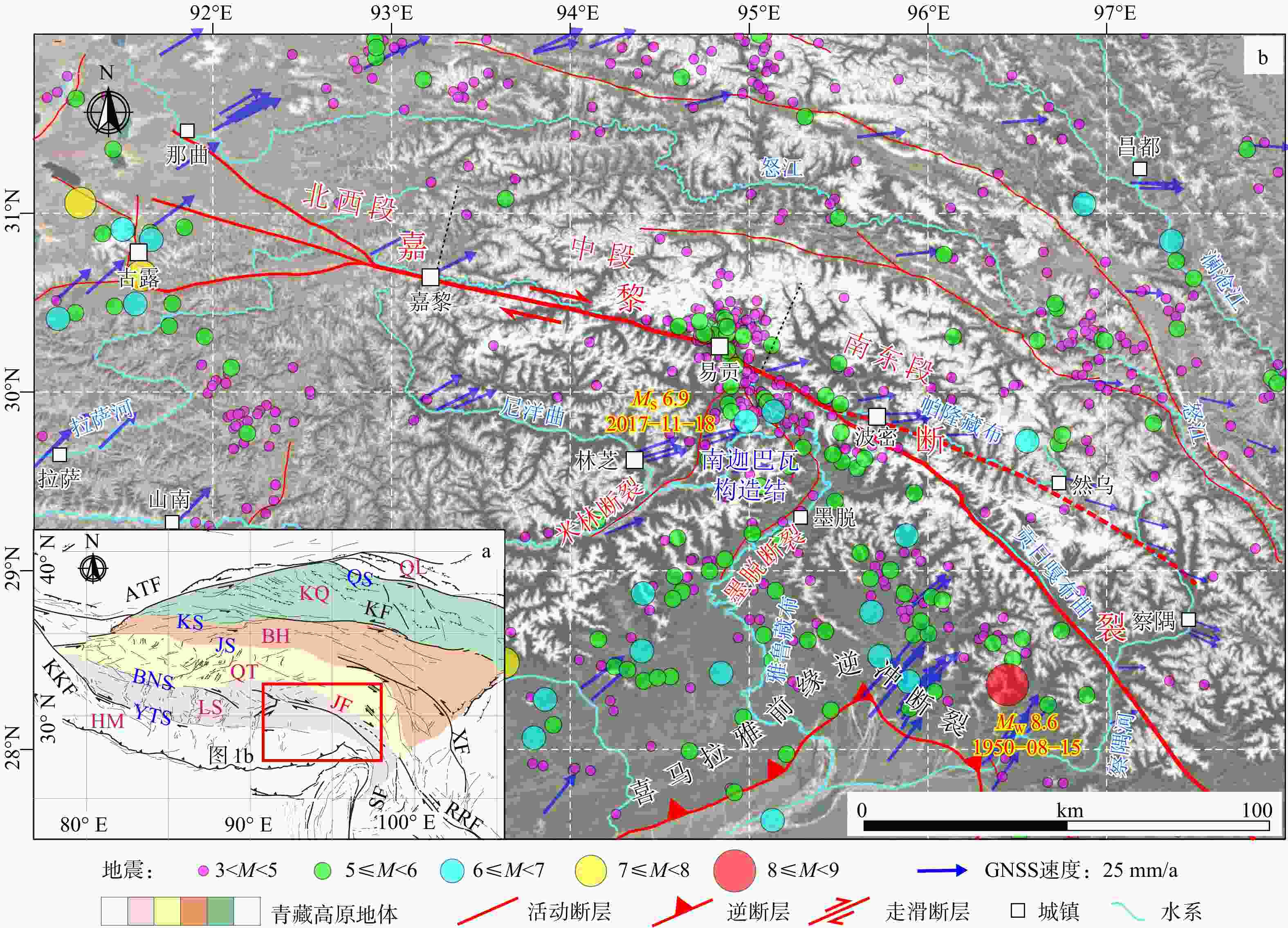
图 1 青藏高原东南部嘉黎断裂带及其周缘地区活动断裂与地震分布图(据Armijo et al.,1989;Zhang et al.,2021修改)
图中地震数据下载自USGS;GNSS数据来源于Wang and Shen,2020;ATF—阿尔金断裂带;KF—昆仑断裂带;KKF—喀喇昆仑断裂带;XF—鲜水河断裂带;RRF—红河断裂带;SF—实皆断裂带;JF—嘉黎断裂带;HM—喜马拉雅地体;LS—拉萨地体;QT—羌塘地体;BH—巴颜喀拉地体;KQ—昆仑–柴达木地体;QL—祁连山地体;YTS—雅鲁藏布江缝合带;BNS—班公湖–怒江缝合带;JS—金沙江缝合带;KS—昆仑缝合带;QS—祁连缝合带a—嘉黎断裂带大地构造背景图;b—青藏高原东南部活动断裂和地震分布图
Figure 1. Map showing the distribution of active faults and earthquakes in the southeastern Tibetan Plateau, centered on the Jiali Fault and its adjacent areas (modified from Armijo et al., 1989; Zhang et al., 2021) (a) Tectonic background map of the Jiali Fault Zone; (b) Distribution of active faults and earthquakes in the southeastern Tibetan Plateau
Earthquakes are from the USGS; Blue vectors are GNSS velocities relative to stable Eurasia (Wang and Shen, 2020); ATF: Altyn Tagh Fault; KF: Kunlun Fault; KKF: Karakorum Fault; XF: Xianshuihe Fault; RRF: Red River Fault; SF: Sagaing Fault; JF: Jiali Fault; HM: Himalaya Terrane; LS: Lhasa Terrane; QT: Qiangtang Terrane; BH: Bayan Har Terrane; KQ: Kunlun–Qaidam Terrane; QL: Qilian Shan Terrane; YTS: Yarlung Tsangpo Suture; BNS: Bangong–Nujiang Suture; JS: Jinsha Suture; KS: Kunlun Suture; QS: Qilian Suture
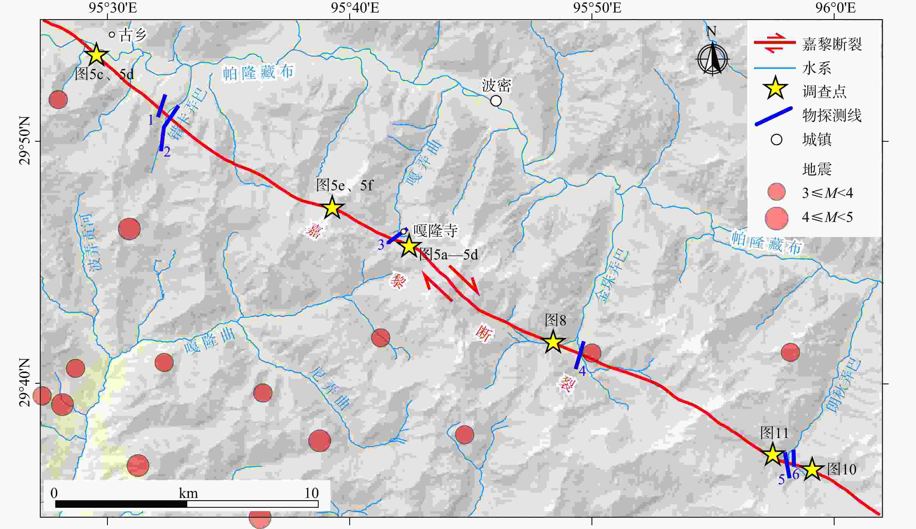
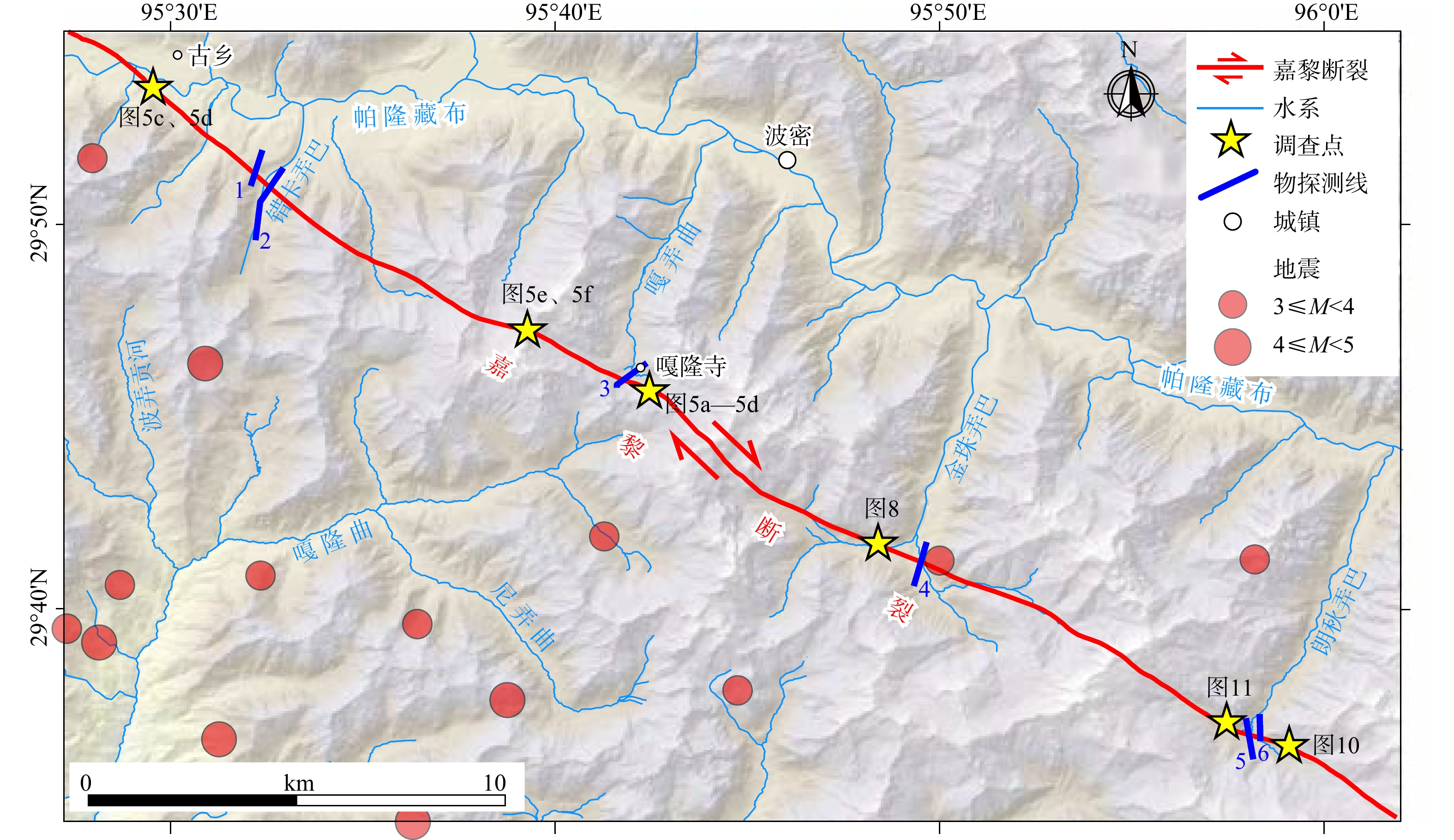
图 2 嘉黎断裂古乡−贡日嘎布段空间展布特征及主要调查研究点分布
Figure 2. Spatial extent of the Jiali Fault from Guxiang to Gongrigabu and the main investigation sites
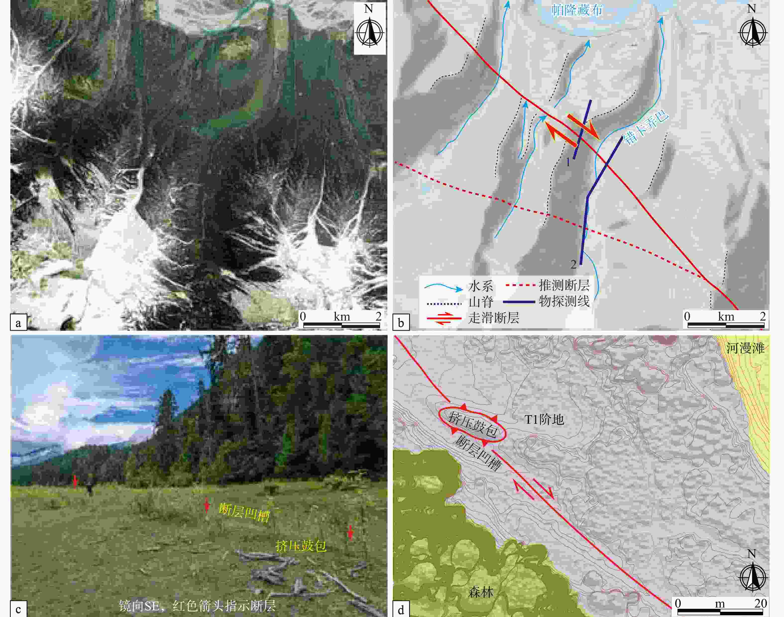
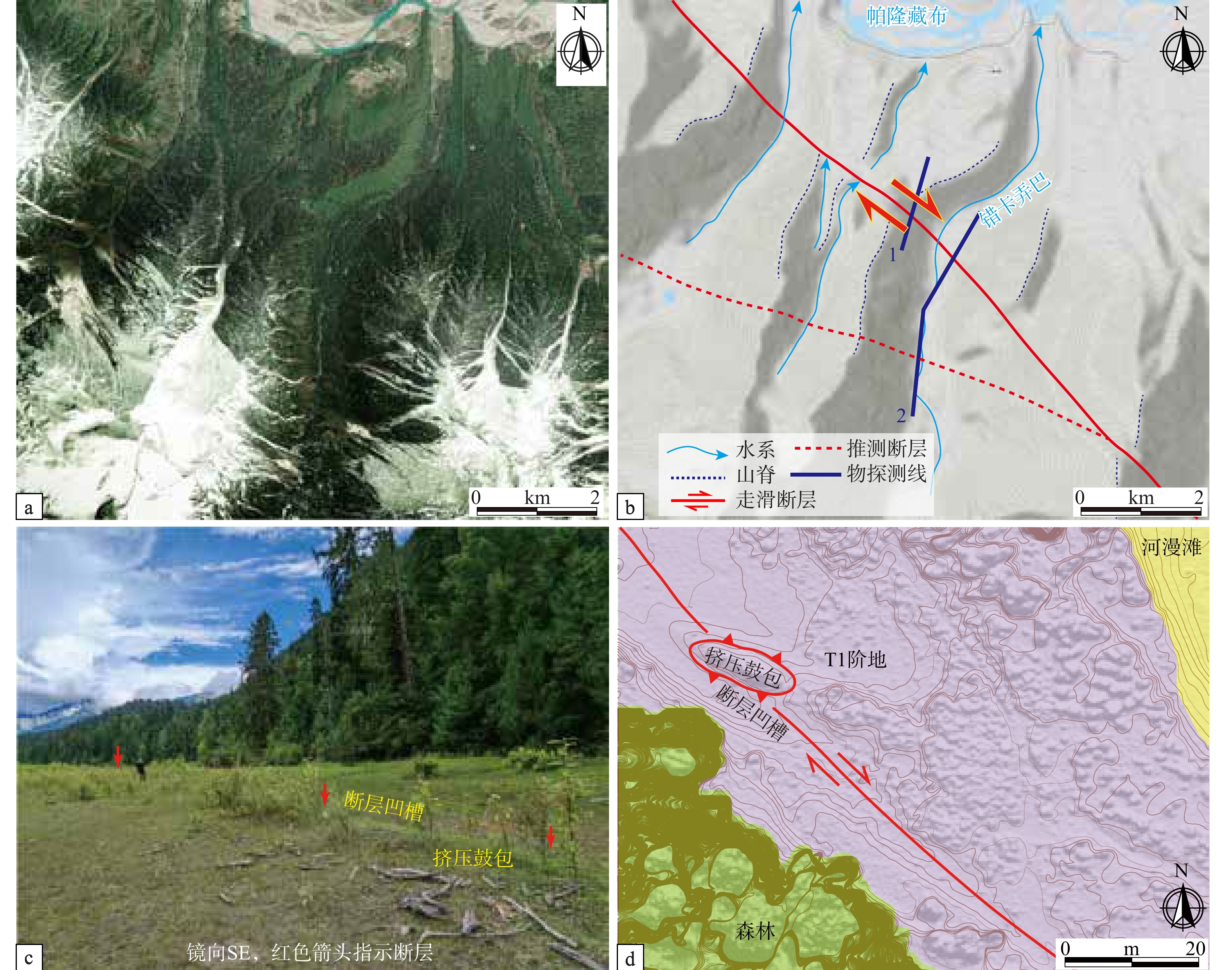
图 3 古乡南−错卡弄巴附近嘉黎断裂卫星影像及野外特征
a—疑似的右行错断河道、山脊卫星影像;b—疑似的右行错断河道、山脊DEM图;c—帕隆藏布南岸T1阶地上疑似的断层凹槽和挤压鼓包;d—基于小型无人机DEM影像的构造地貌解译图
Figure 3. Satellite images and geomorphological features of the Jiali Fault from south of Guxiang to Cuokanongba
(a) Satellite image showing the possible dextral offset of river courses and mountain ridges; (b) DEM map showing the possible dextral offset of river courses and mountain ridges; (c) Field photo showing a possible fault trough and push-up ridge on the T1 terrace along the southern bank of the Parlung Tsangpo River; (d) Tectonic and geomorphic interpretation of the DEM derived from a small UAV
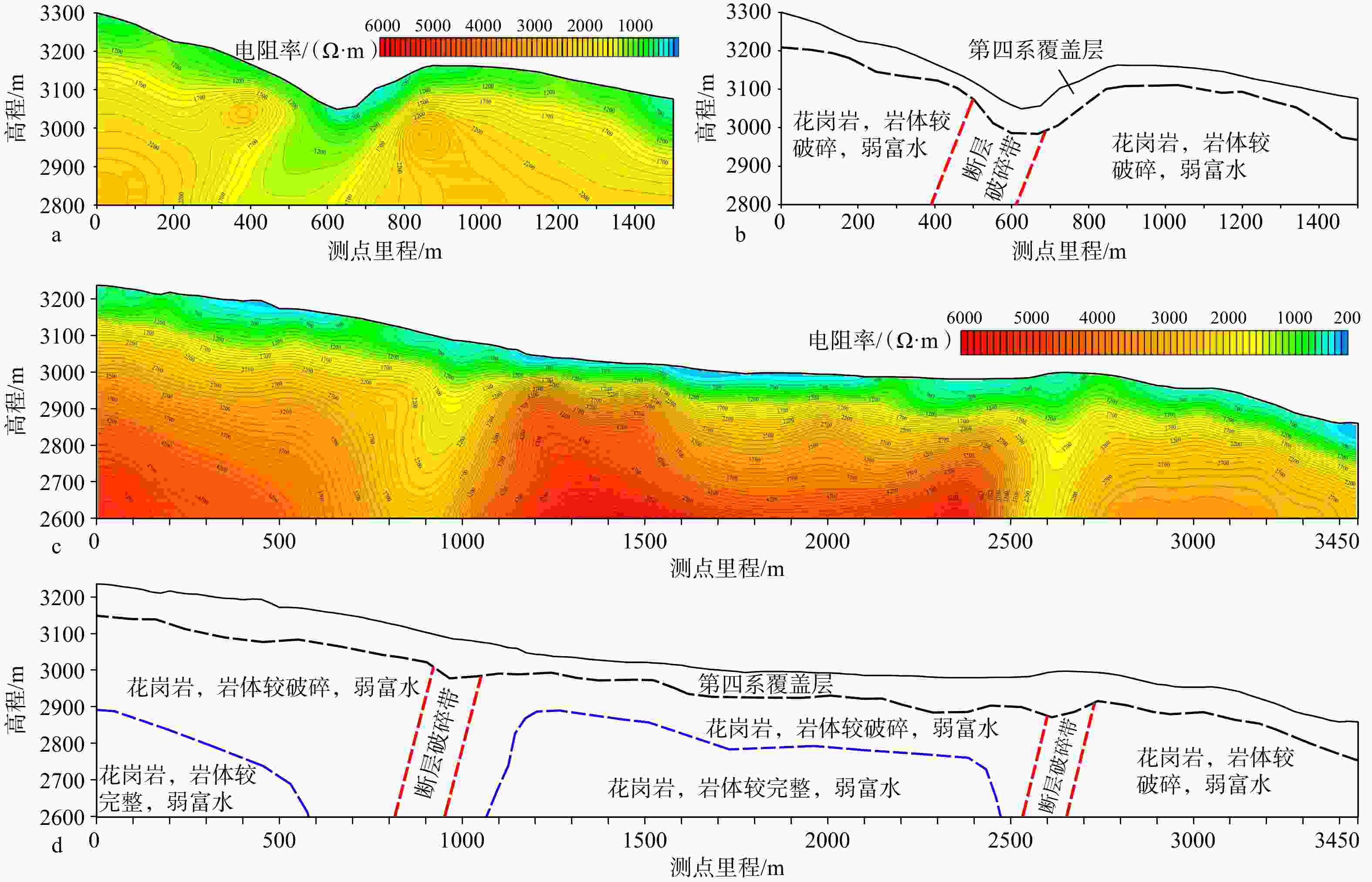
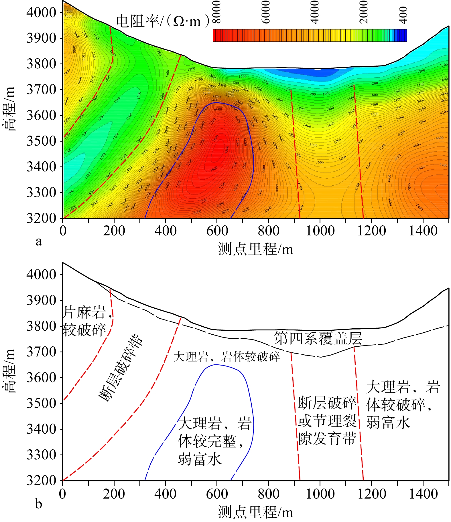
图 4 错卡弄巴附近1号和2号大地电磁剖面揭示的嘉黎断裂特征(剖面位置见图2)
a—1号大地电磁剖面反演结果;b—1号剖面地质解译图;c—2号大地电磁剖面反演结果;d—2号剖面地质解译图
Figure 4. Inversion results and geological interpretation of magnetotelluric profiles 1 and 2 across the Jiali Fault near Cuokanongba (Locations of the profiles are shown in Fig. 2)
(a) Inversion result of magnetotelluric profile 1; (b) Geological interpretation of profile 1; (c) Inversion result of magnetotelluric profile 2; (d) Geological interpretation of profile 2
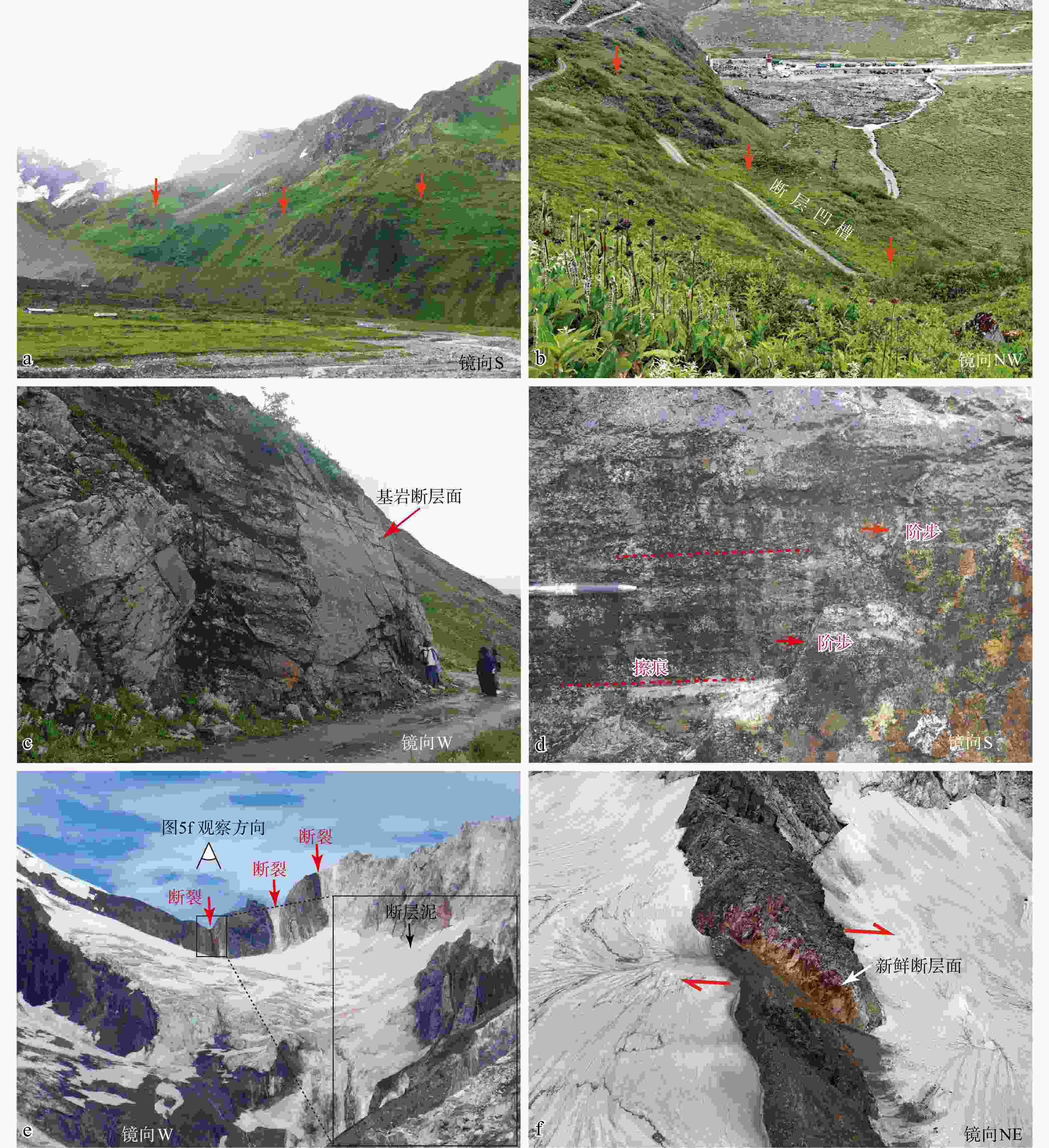
图 5 嘎隆寺附近嘉黎断裂构造地貌和岩石变形特征
a—线性展布的坡中平台;b—嘎隆拉雪山北坡的疑似断层槽谷;c—基岩断层面;d—断层擦痕和阶步;e—嘉黎断裂上的断层垭口地貌及黑色断层泥;f—疑似的山脊右行错断
Figure 5. Tectonic geomorphology and deformation of bedrock along the Jiali Fault near Galong Temple
(a) Linearly distributed terraces on the slope; (b) Fault trough on the northern slope of Galongla Range; (c) Fault plane developed in bedrock; (d) Slickensides and fault steps; (e) Mountain pass formed by faulting with black gouge in the fault core; (f) Right-lateral offset ridge
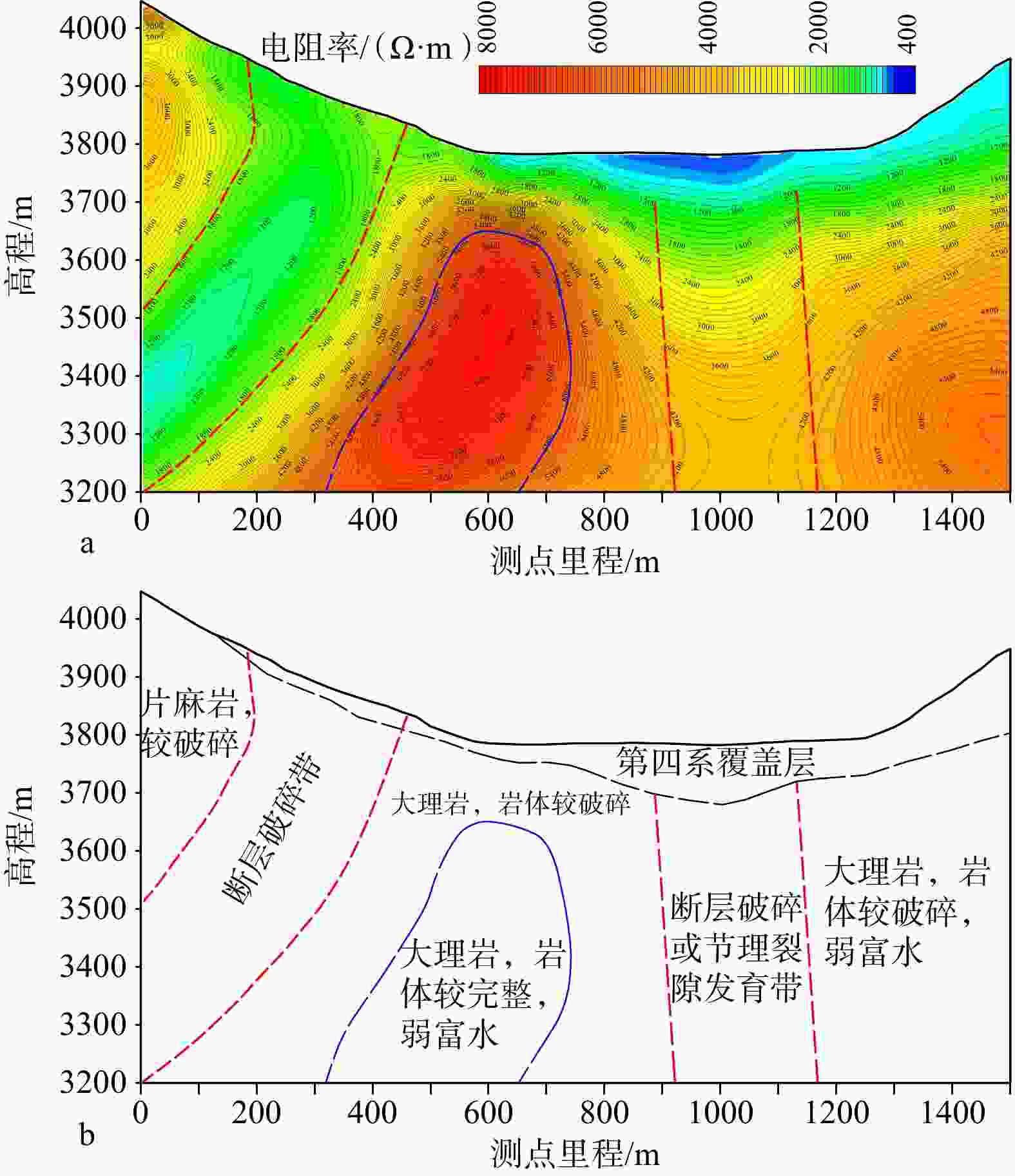
图 6 嘎隆拉盆地内3号大地电磁剖面揭示的嘉黎断裂特征(剖面位置见图2)
a—3号大地电磁剖面反演结果;b—3号剖面地质解译图
Figure 6. Inversion results and geological interpretation of magnetotelluric profile 3 across the Jiali Fault in Galongla Basin (Location of the profile is shown in Fig. 2)
(a) Inversion result of magnetotelluric profile 3; (b) Geological interpretation of profile 3
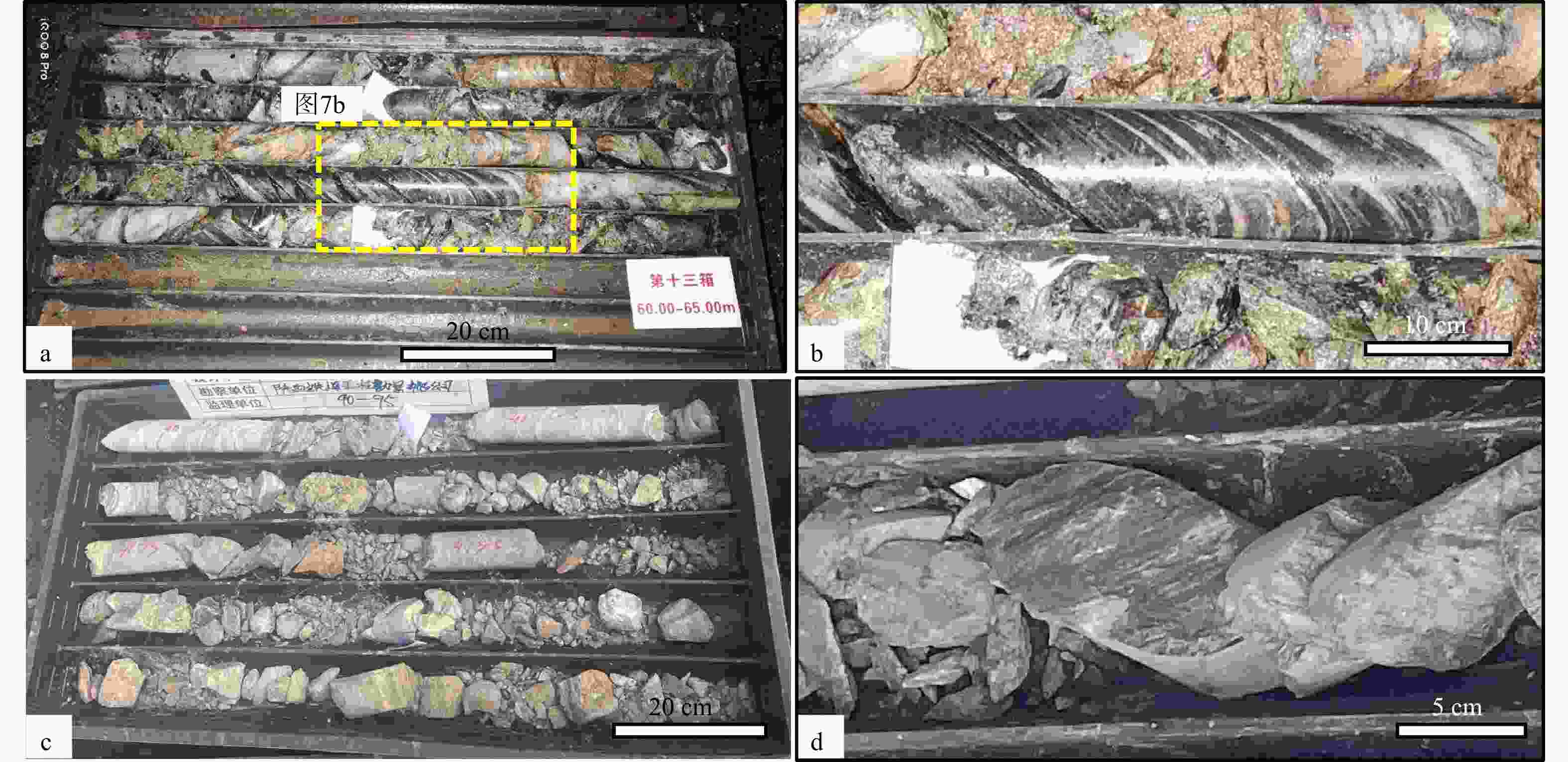
图 7 嘎隆拉水平钻孔和竖直钻孔岩心破碎特征
a—水平钻孔岩心破碎特征;b—水平钻孔岩心面理化特征;c—竖直钻孔岩心破碎特征;d—竖直钻孔中的断层滑动面
Figure 7. Fragmentation characteristics of drilling cores from horizontal and vertical boreholes
(a) Fragmentation characteristics of drilling cores from a horizontal borehole; (b) Foliation characteristics of a drilling core from a horizontal borehole; (c) Fragmentation characteristics of drilling cores from a vertical borehole; (d) Fault slip surface in the drilling core from a vertical borehole
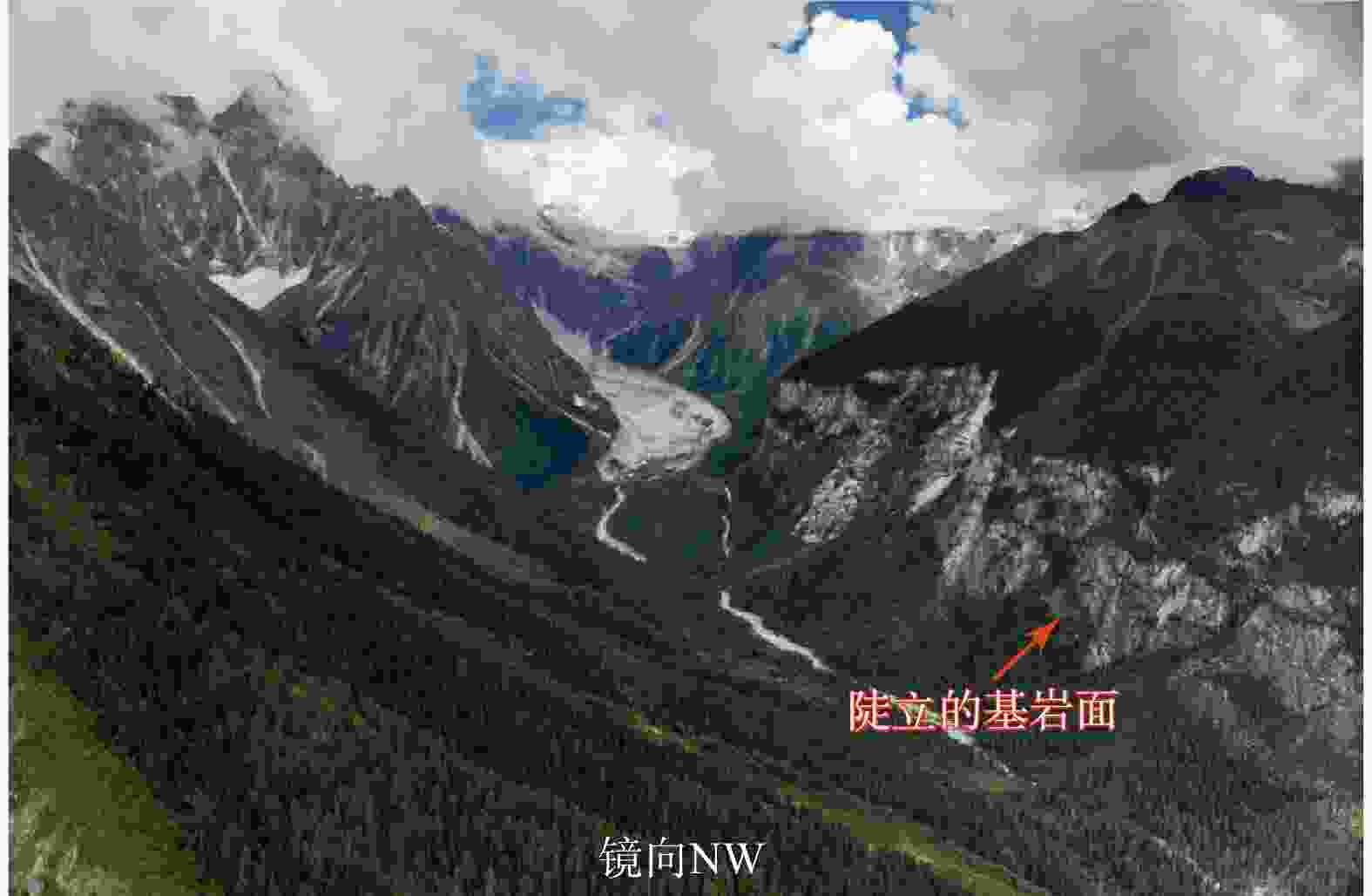
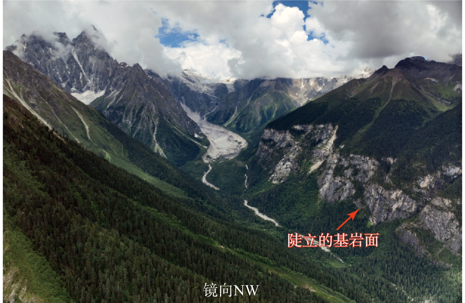
图 8 金珠弄巴北岸发育的陡立基岩面
Figure 8. Steep bedrock surface developed on the northern bank of the Jinzhunongba River
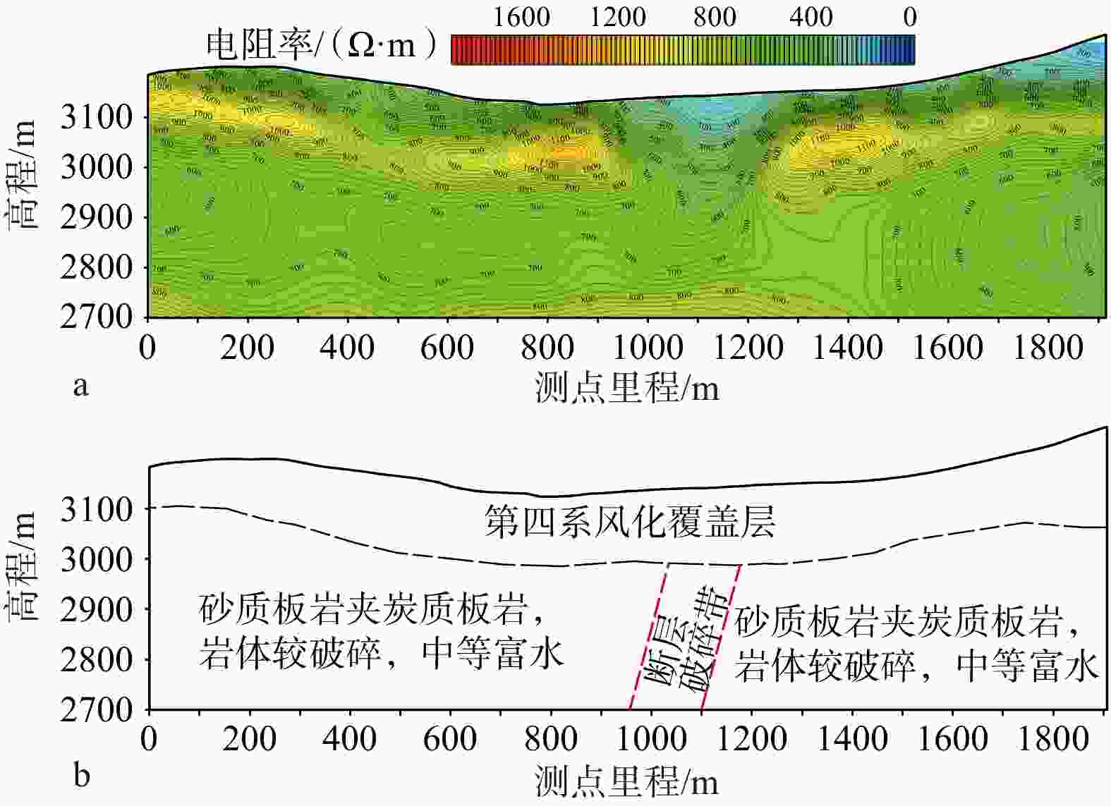
图 9 穿过金珠弄巴河谷的4号大地电磁剖面(剖面位置见图2)
a—4号大地电磁剖面反演结果;b—4号剖面地质解译图
Figure 9. Inversion result and geological interpretation of magnetotelluric profile 4 across Jinzhunongba Valley (Location of the profile is shown in Fig. 2)
(a) Inversion result of the magnetotelluric profile 4; (b) Geological interpretation of profile 4
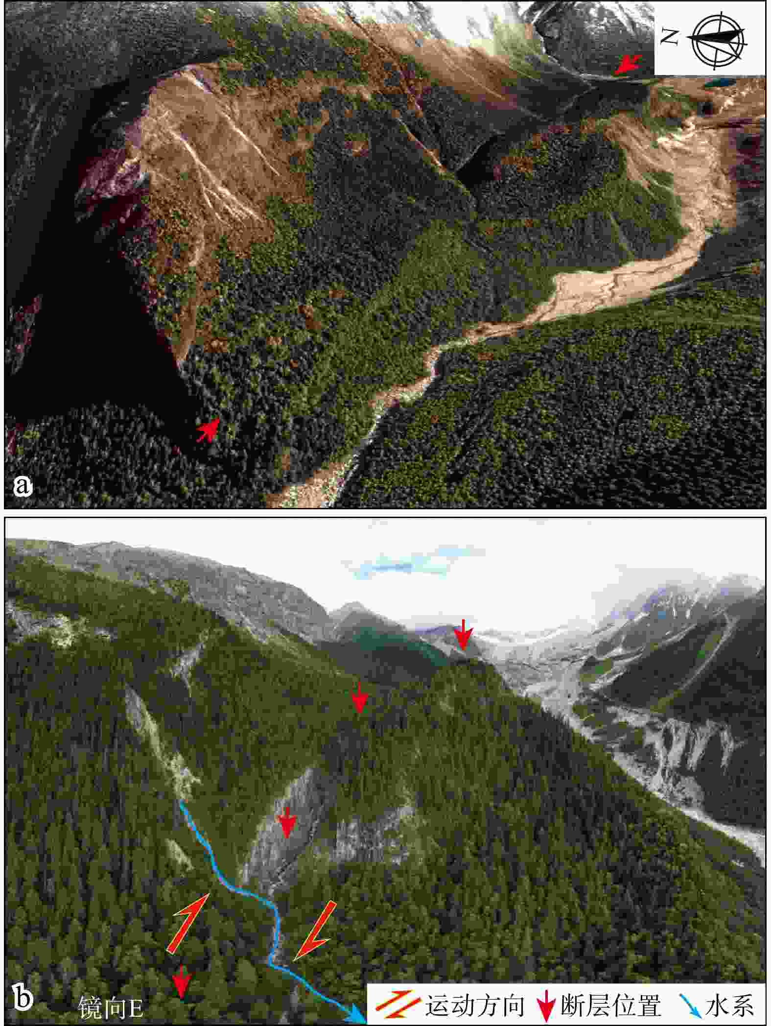
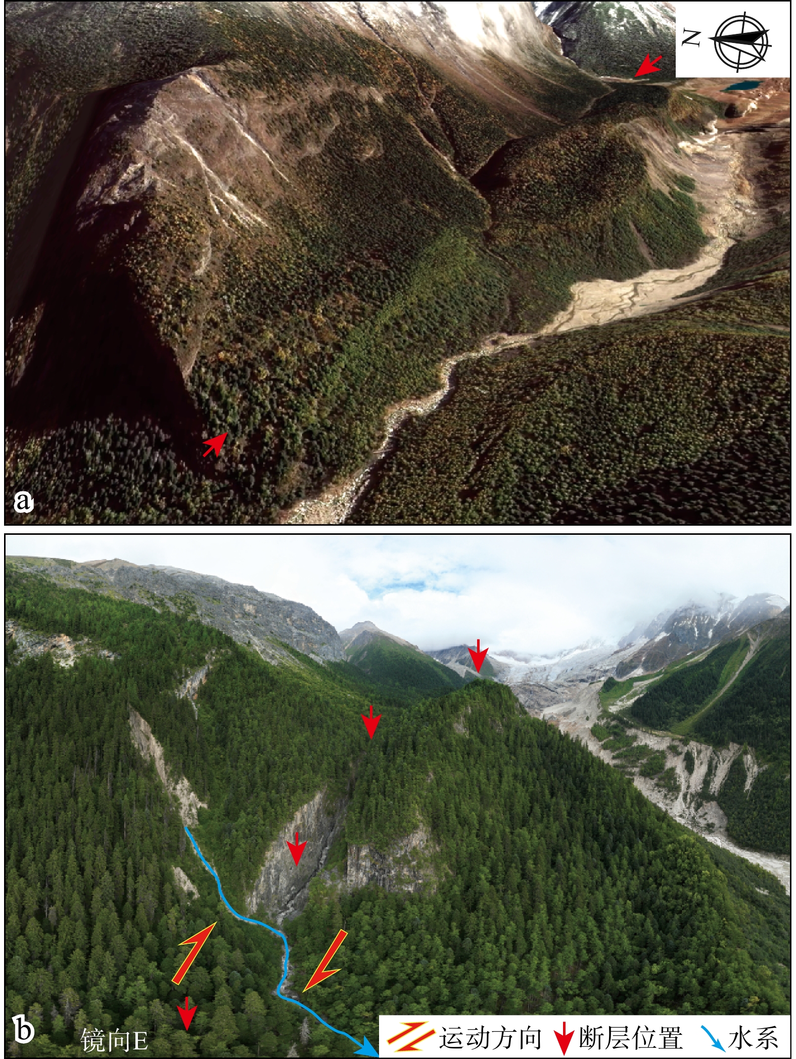
图 10 嘉黎断裂在朗秋冰川附近的构造地貌特征
a—谷歌卫星影像图;b—无人机照片
Figure 10. Tectonic geomorphic features of the Jiali Fault near the Langqiu Glacier
(a) Google Earth satellite image; (b) UAV photograph
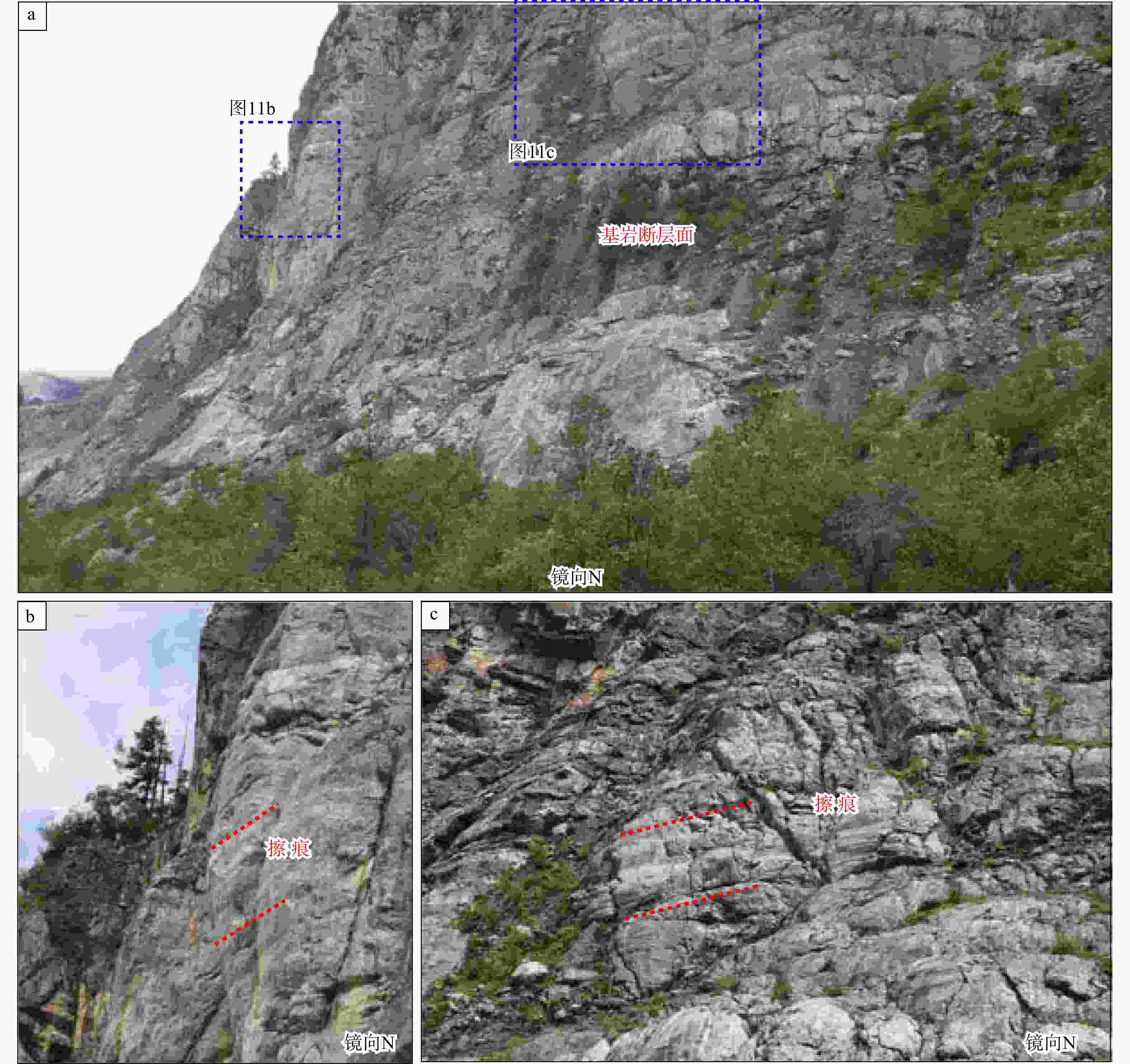
图 11 朗秋冰川附近基岩断层面与水平擦痕
a—基岩断层面;b—基岩断层面上近水平擦痕;c—近水平擦痕
Figure 11. Fault plane and slickensides developed in bedrock near Langqiu Glacier
(a) Fault plane in bedrock; (b) Horizontal slickensides on the fault plane; (c) Horizontal slickensides
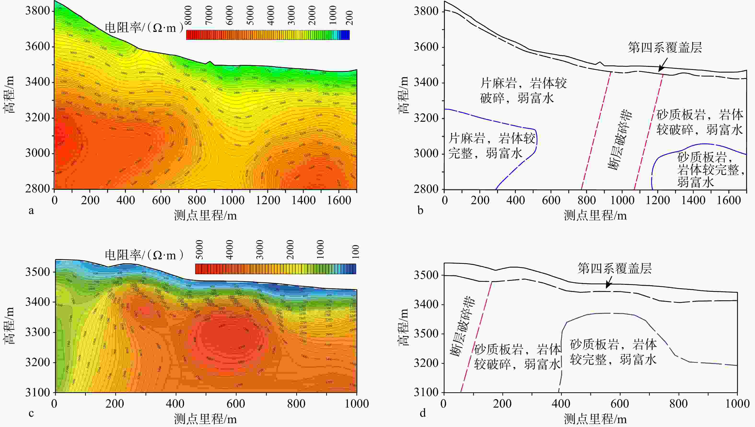
图 12 朗秋冰川附近5和6号大地电磁剖面揭示的嘉黎断裂特征(剖面位置见图2)
a—5号大地电磁剖面反演结果;b—5号剖面地质解译图;c—6号大地电磁剖面反演结果;d—6号剖面地质解译图
Figure 12. Inversion results and geological interpretation of magnetotelluric profiles 5 and 6 across the Jiali Fault near Langqiu Glacier (Locations of the profiles are shown in Fig. 2)
(a) Inversion results of magnetotelluric profile 5; (b) Geological interpretation of profile 5; (c) Inversion results of magnetotelluric profile 6; (b) Geological interpretation of profile 6
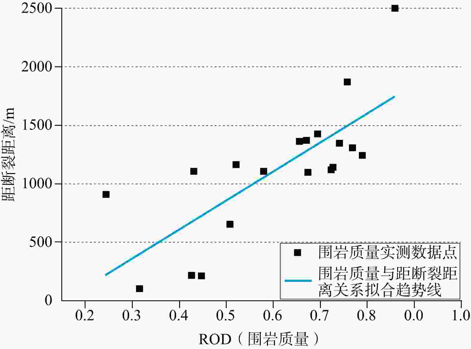
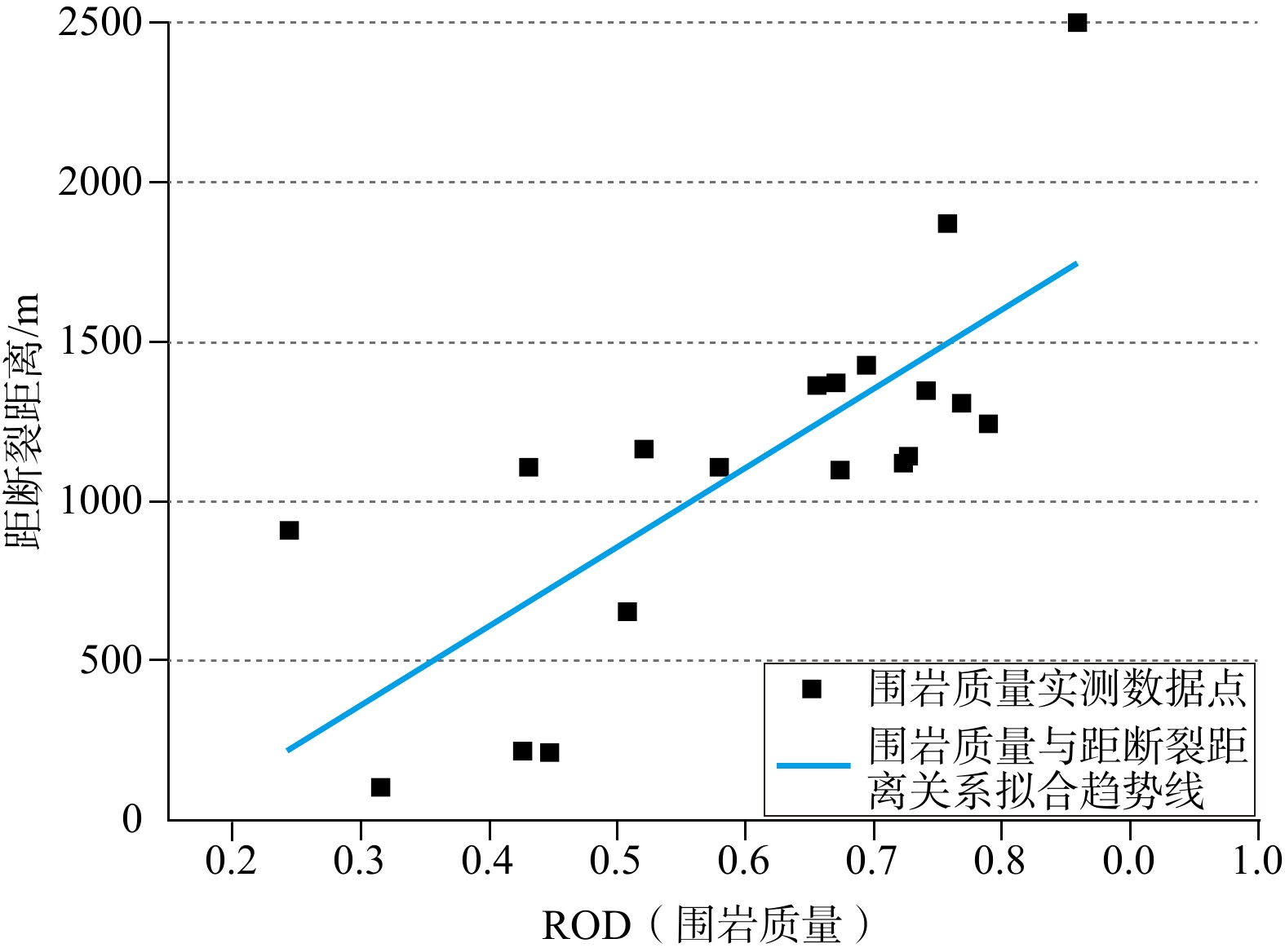
图 13 钻孔岩石质量指标RQD(Rock Quality Designation)值与嘉黎断裂距离相关性图(中铁第一勘察设计院集团有限公司,2020)
Figure 13. Correlation between borehole RQD values and the distance from the Jiali Fault (China Railway First Survey and Design Institute Group Co., Ltd., 2020)
-
[1] ARMIJO R, TAPPONNIER P, MERCIER J L, et al., 1986. Quaternary extension in southern Tibet: Field observations and tectonic implications[J]. Journal of Geophysical Research: Solid Earth, 91(B14): 13803-13872. doi: 10.1029/JB091iB14p13803 [2] ARMIJO R, TAPPONNIER P, HAN T L, 1989. Late Cenozoic right-lateral strike-slip faulting in southern Tibet[J]. Journal of Geophysical Research: Solid Earth, 94(B3): 2787-2838. [3] BAI L, LI G H, SONG B W, 2017. The source parameters of the M6.9 Mainling, Tibet earthquake and its tectonic implications[J]. Chinese Journal of Geophysics, 60(12): 4956-4963. (in Chinese with English abstract) [4] CHEN P G, HE X H, XU S F, et al., 2023. Earthquake relocation and regional stress field around the eastern Himalayan syntaxis[J]. Reviews of Geophysics and Planetary Physics, 54(6): 667-683. (in Chinese with English abstract) [5] CHENG Y, JIANG Y N, HOU Z J, et al., 2024. InSAR deformation observation and regional severe earthquake hazard analysis of the 2016 and 2022 strong earthquake activities in Menyuan, Qinghai[J]. Journal of Geomechanics, 30(6): 965-977. (in Chinese with English abstract) doi: 10.12090/j.issn.1006-6616.2023197 [6] China Railway First Survey & Design Institute Group Co. , 2020. Evaluation report on the impact of the eastern Himalayan syntaxis and the Jiali fault on the construction and operation of the Yigong tunnel project[R]. (in Chinese) [7] DING L, ZHONG D H, 2013. The tectonic evolution of the eastern Himalaya syntaxis since the collision of the Indian and Eurasian plates[J]. Chinese Journal of Geology, 48(2): 317-333. (in Chinese with English abstract) [8] DING L, ZHONG D H, YIN A, et al., 2001. Cenozoic structural and metamorphic evolution of the eastern Himalayan syntaxis (Namche Barwa)[J]. Earth and Planetary Science Letters, 192(3): 423-438. doi: 10.1016/S0012-821X(01)00463-0 [9] HAN S, WU Z H, GAO Y, et al., 2022. Surface rupture investigation of the 2022 Menyuan MS 6.9 Earthquake, Qinghai, China: Implications for the fault behavior of the Lenglongling fault and regional intense earthquake risk[J]. Journal of Geomechanics, 28(2): 155-168. (in Chinese with English abstract) [10] LEE H Y, CHUNG S L, WANG J R, et al., 2003. Miocene Jiali faulting and its implications for Tibetan tectonic evolution[J]. Earth and Planetary Science Letters, 205(3-4): 185-194. doi: 10.1016/S0012-821X(02)01040-3 [11] LI H Q, LI T F, HE Z Y, et al. , 2022. Early Cretaceous hydrous mafic magmatism in the eastern Lhasa terrane, Tibet: Petrogenesis and constraints on the early history of the eastern Jiali (Parlung) fault[J]. Lithos, 418-419: 106686. [12] LI K J, WANG H, CHEN L C, et al., 2025. Late Quaternary slip rates and paleoseismicity on the western segment of the Jiali fault zone and implications for tectonic deformation and slip partitioning in the central Tibetan Plateau[J]. Tectonics, 44(7): e2025TC009002. doi: 10.1029/2025TC009002 [13] LIANG J W, HAN H X, 2013. Amplification of ground motion around fault fracture zone (I) basic laws[J]. Earthquake Engineering and Engineering Dynamics, 33(5): 9-19. (in Chinese with English abstract) doi: 10.13197/j.eeev.2013.05.9.liangjw.002 [14] LIN T H, LO C H, CHUNG S L, et al., 2009. 40Ar/39Ar dating of the Jiali and Gaoligong shear zones: Implications for crustal deformation around the eastern Himalayan Syntaxis[J]. Journal of Asian Earth Sciences, 34(5): 674-685. doi: 10.1016/j.jseaes.2008.10.009 [15] LIU S J, LAN H X, ZHANG N, 2022. Geomechanical analysis of major engineering region in middle segment of Jiali fault[J]. Journal of Engineering Geology, 30(6): 1947-1961. (in Chinese with English abstract) doi: 10.13544/j.cnki.jeg.2022-0623 [16] LIU S J, LAN H X, STROM A, et al., 2024. Spatial segmentation of Jiali Fault’s Holocene activity in the southeastern Tibetan Plateau[J]. npj Natural Hazards, 1(1): 42. doi: 10.1038/s44304-024-00038-3 [17] LU S M, WU Z H, HAN S, et al., 2025. Quaternary activity characteristics of the Yiong‐Zayu segment of the Jiali fault zone[J]. Earth Science, 50(8): 3052-3069. (in Chinese with English abstract) [18] MA X, FU L, LI T F, et al., 2021. Analysis of geothermal origin in eastern Himalayan Syntaxis[J]. Geoscience, 35(1): 209-219. (in Chinese with English abstract) doi: 10.19657/j.geoscience.1000-8527.2021.016 [19] PAN G T, HAO G J, FENG Y F, et al., 2009. Subdivision of tectonic units in China[J]. Geology in China, 36(1): 1-28. (in Chinese with English abstract) [20] PAN J W, BAI M K, LI C, et al., 2021. Coseismic surface rupture and seismogenic structure of the 2021-05-22 Maduo (Qinghai) MS7.4 earthquake[J]. Acta Geologica Sinica, 95(6): 1655-1670. (in Chinese with English abstract) [21] PAN J W, LI H B, CHEVALIER M L, et al., 2022. Coseismic surface rupture and seismogenic structure of the 2022 MS6.9 Menyuan earthquake, Qinghai Province, China[J]. Acta Geologica Sinica, 96(1): 215-231. (in Chinese with English abstract) [22] REN J W, SHEN J, CAO Z Q, et al., 2000. Quaternary faulting of Jiali fault, southeast Tibetan Plateau[J]. Seismology and Geology, 22(4): 344-350. (in Chinese with English abstract) [23] ROYDEN L H, BURCHFIEL B C, VAN DER HILST R D, 2008. The geological evolution of the Tibetan Plateau[J]. Science, 321(5892): 1054-1058. doi: 10.1126/science.1155371 [24] SHEN J, REN J W, WANG Y P, et al. , 2001. The Quaternary right lateral strike slipping of the Jiali fault zone in south Tibet [A]. Study of the Recent Deformation and Dynamics of the Lithosphere in Qinghai-Xizang Plateau[C]. Beijing: Seismological Press. (in Chinese with English abstract) [25] SHEN J, WANG Y P, REN J W, et al., 2003. Quaternary dextral shearing and crustal movement in Southeast Tibetan Plateau[J]. Xinjiang Geology, 21(1): 120-125. (in Chinese with English abstract) [26] SONG J, TANG F T, DENG Z H, et al., 2013. Late Quaternary movement characteristic of Jiali fault in Tibetan Plateau[J]. Acta Scientiarum Naturalium Universitatis Pekinensis, 49(6): 973-980. (in Chinese with English abstract) [27] TANG F T, SONG J, CAO Z Q, et al., 2010. The movement characters of main faults around eastern Himalayan Syntaxis revealed by the latest GPS data[J]. Chinese Journal of Geophysics, 53(9): 2119-2128. (in Chinese with English abstract) [28] TAPPONNIER P, PELTZER G, LE DAIN A Y, et al., 1982. Propagating extrusion tectonics in Asia: New insights from simple experiments with plasticine[J]. Geology, 10(12): 611-616. doi: 10.1130/0091-7613(1982)10<611:petian>2.0.co;2 [29] TAPPONNIER P, PELTZER G, ARMIJO R, 1986. On the mechanics of the collision between India and Asia[J]. Geological Society, London, Special Publications, 19(1): 113-157. doi: 10.1144/GSL.SP.1986.019.01.07 [30] TAPPONNIER P, ZHIQIN X, ROGER F, et al., 2001. Oblique stepwise rise and growth of the Tibet Plateau[J]. Science, 294(5547): 1671-1677. doi: 10.1126/science.105978 [31] TIAN Z, YANG Z Q, WANG S D, 2020. Moment deficits on the major faults and earthquake hazard assessment in the eastern Himalayan syntaxis[J]. Seismology and Geology, 42(1): 33-49. (in Chinese with English abstract) [32] WAN J W, CHU H L, LI B, et al., 2021. Characteristics, types, main causes and development of high-position geohazard chains along the Jiali fault zone, Tibet, China[J]. The Chinese Journal of Geological Hazard and Control, 32(3): 51-60. (in Chinese with English abstract) doi: 10.16031/j.cnki.issn.1003-8035.2021.03-07 [33] WANG H, LI K J, CHEN L C, et al., 2020. Evidence for Holocene activity on the Jiali fault, an active block boundary in the southeastern Tibetan Plateau[J]. Seismological Research Letters, 91(3): 1776-1780. doi: 10.1785/0220190371 [34] WANG M, SHEN Z K, 2020. Present-day crustal deformation of continental China derived from GPS and its tectonic implications[J]. Journal of Geophysical Research: Solid Earth, 125(2): e2019JB018774. doi: 10.1029/2019JB018774 [35] WELLS D L, COPPERSMITH K J, 1994. New Empirical Relationships among Magnitude, Rupture Length, Rupture Width, Rupture Area, and Surface Displacement[J]. Bulletin of the Seismological Society of America, 84(4): 974-1002. doi: 10.1785/BSSA0840040974 [36] WU Z H, 2024. The earthquake-controlling process of continental collision-extrusion active tectonic system around the Qinghai-Tibet Plateau: A case study of strong earthquakes since 1990[J]. Journal of Geomechanics, 30(2): 189-205. (in Chinese with English abstract) [37] XU X W, HAN Z J, YANG X P, et al. , 2016. Seismotectonic Map in China and its Adjacent Regions[M]. Beijing: Seismological Press. (in Chinese). [38] XU Z Q, LI H B, TANG Z M, et al., 2011. The transformation of the terrain structures of the Tibet Plateau through large-scale strike-slip faults[J]. Acta Petrologica Sinica, 27(11): 3157-3170. (in Chinese with English abstract) [39] XUE Y G, QU J K, PENG J B, et al., 2026. Main Unfavorable Geological Conditions and Gigantic Engineering Geological Problems of the Lower Reaches of the Yarlung Zangbo River[J]. Geoscience, 40(01): 1-30. (in Chinese with English abstract) [40] YAN Y, 2023. The tunnel damage effects and implications of the coseismic rupture of the Menyuan MS 6.9 Earthquake in Qinghai, China[J]. Journal of Geomechanics, 29(6): 869-878. (in Chinese with English abstract) [41] YAO J M, YAO X, WANG Y B, et al., 2024. Current active fault distribution and slip rate along the middle section of the Jiali-Chayu fault from Sentinel-1 InSAR observations (2017-2022)[J]. Earth, Planets and Space, 76(1): 21. doi: 10.1186/s40623-024-01962-4 [42] ZHANG B, CAI F L, CHEN S Y, et al., 2020. Sinistral strike-slip shearing along the Jiali shear zone around the eastern Himalaya syntaxis region: Evidences for Oligocene eastward limited translation of Tibet[J]. Journal of Structural Geology, 139: 104136. doi: 10.1016/j.jsg.2020.104136 [43] ZHANG L, LIANG S M, YANG X P, et al., 2021. Geometric and kinematic evolution of the Jiali fault, eastern Himalayan Syntaxis[J]. Journal of Asian Earth Sciences, 212: 104722. doi: 10.1016/j.jseaes.2021.104722 [44] ZHANG P Z, DENG Q D, ZHANG G M, et al., 2003. Active tectonic blocks and strong earthquakes in the continent of China[J]. Science in China Series D: Earth Sciences, 46(24): 13-24. doi: 10.1360/03dz0002 [45] ZHANG Y S, GUO C B, LI X Q, et al., 2021. Key problems on hydro-engineering-environmental geology along the Sichuan-Tibet Railway corridor: Current status and development direction[J]. Hydrogeology & Engineering Geology, 48(5): 1-12. (in Chinese with English abstract) doi: 10.16030/j.cnki.issn.1000-3665.202104001 [46] ZHAO Y F, GONG W B, JIANG W, et al., 2021. Multi-stage characteristics and tectonic significance of the Jiali fault in Guxiang-Tongmai section, South Tibet[J]. Geoscience, 35(1): 220-233. (in Chinese with English abstract) [47] ZHAO Z D, LEI H S, BAI Z M, et al., 2025. Crustal structure and chemical composition of the Yingpan-Jinding-Beiya-Panlong transect in southeastern Tibetan Plateau[J]. Earth Science Frontiers, 2025, 32(06): 256-275. (in Chinese with English abstract) [48] ZHONG N, GUO C B, HUANG X L, et al., 2021. Late Quaternary activity and paleoseismic records of the middle south section of the Jiali- Chayu fault[J]. Acta Geologica Sinica, 95(12): 3642-3659. (in Chinese with English abstract) [49] 张宁, 张文哲, 李郎平, 等. 青藏高原地温时空分布及某重大线性工程深部高地温风险分析[J]. 工程地质学报, 2022, 30(03): 708-719. [50] 白玲, 李国辉, 宋博文, 2017. 2017年西藏米林6.9级地震震源参数及其构造意义[J]. 地球物理学报, 60(12): 4956-4963. [51] 陈平光, 何骁慧, 徐树峰, 等, 2023. 喜马拉雅东构造结地震精定位及其区域应力场研究[J]. 地球与行星物理论评(中英文), 54(6): 667-683. [52] 程燕, 蒋亚楠, 侯中健, 等, 2024. 2016年和2022年青海门源强震活动的InSAR形变观测与区域强震危险性分析[J]. 地质力学学报, 30(6): 965-977, doi: 10.12090/j.issn.1006-6616.2023197. [53] 丁林, 钟大赉, 2013. 印度与欧亚板块碰撞以来东喜马拉雅构造结的演化[J]. 地质科学, 48(2): 317-333. doi: 10.3969/j.issn.0563-5020.2013.02.001 [54] 韩帅, 吴中海, 高扬, 等, 2022. 2022年1月8日青海门源MS 6.9地震地表破裂考察的初步结果及对冷龙岭断裂活动行为和区域强震危险性的启示[J]. 地质力学学报, 28(2): 155-168. doi: 10.12090/j.issn.1006-6616.2022013 [55] 梁建文, 韩红霞, 2013. 断层破碎带对地震动的放大作用: (Ⅰ)基本规律[J]. 地震工程与工程振动, 33(5): 9-19, doi: 10.13197/j.eeev.2013.05.9.liangjw.002. [56] 刘世杰, 兰恒星, 张宁, 2022. 嘉黎断裂中段重大工程区地质力学分析[J]. 工程地质学报, 30(6): 1947-1961, doi: 10.13544/j.cnki.jeg.2022-0623. [57] 陆诗铭, 吴中海, 韩帅, 等, 2025. 嘉黎断裂带易贡-察隅段第四纪活动性特征[J]. 地球科学, 50(8): 3052-3069. [58] 马鑫, 付雷, 李铁锋, 等, 2021. 喜马拉雅东构造结地区地热成因分析[J]. 现代地质, 35(1): 209-219, doi: 10.19657/j.geoscience.1000-8527.2021.016. [59] 潘桂棠, 郝国杰, 冯艳芳, 等, 2009. 中国大地构造单元划分[J]. 中国地质, 36(1): 1-28. [60] 潘家伟, 白明坤, 李超, 等, 2021. 2021年5月22日青海玛多MS7.4地震地表破裂带及发震构造[J]. 地质学报, 95(6): 1655-1670. doi: 10.3969/j.issn.0001-5717.2021.06.001 [61] 潘家伟, 李海兵, CHEVALIER M L, 等, 2022. 2022年青海门源MS6.9地震地表破裂带及发震构造研究[J]. 地质学报, 96(1): 215-231. doi: 10.3969/j.issn.0001-5717.2022.01.018 [62] 任金卫, 沈军, 曹忠权, 等, 2000. 西藏东南部嘉黎断裂新知[J]. 地震地质, 22(4): 344-350. [63] 沈军, 任金卫, 汪一鹏, 等, 2001. 西藏南部嘉黎断裂带第四纪右旋走滑运动研究[A]. 青藏高原岩石圈现今变动与动力学研究论文集[C]. 北京: 地震出版社. [64] 沈军, 汪一鹏, 任金卫, 等, 2003. 青藏高原东南部第四纪右旋剪切运动[J]. 新疆地质, 21(1): 120-125. doi: 10.3969/j.issn.1000-8845.2003.01.019 [65] 宋键, 唐方头, 邓志辉, 等, 2013. 青藏高原嘉黎断裂晚第四纪运动特征[J]. 北京大学学报(自然科学版), 49(6): 973-980. [66] 唐方头, 宋键, 曹忠权, 等, 2010. 最新GPS数据揭示的东构造结周边主要断裂带的运动特征[J]. 地球物理学报, 53(9): 2119-2128. doi: 10.3969/j.issn.0001-5733.2010.09.012 [67] 田镇, 杨志强, 王师迪, 2020. 喜马拉雅东构造结主要断裂的地震矩亏损与危险性评估[J]. 地震地质, 42(1): 33-49. [68] 万佳威, 褚宏亮, 李滨, 等, 2021. 西藏嘉黎断裂带沿线高位链式地质灾害发育特征分析[J]. 中国地质灾害与防治学报, 32(3): 51-60, doi: 10.16031/j.cnki.issn.1003-8035.2021.03-07. [69] 吴中海, 2024. 青藏高原陆陆碰撞-挤出活动构造体系控震作用: 以1990年以来强震活动为例[J]. 地质力学学报, 30(2): 189-205. doi: 10.12090/j.issn.1006-6616.2023186 [70] 徐锡伟, 韩竹军, 杨晓平, 等. 2016. 中国及邻区地震构造图[M]. 北京: 地震出版社. [71] 许志琴, 李海兵, 唐哲民, 等, 2011. 大型走滑断裂对青藏高原地体构架的改造[J]. 岩石学报, 27(11): 3157-3170. [72] 薛翊国, 渠敬凯, 彭建兵, 等, 2026. 雅鲁藏布江下游主要不良地质条件与重大工程地质问题[J]. 现代地质, 2026, 40 (01) : 1-30. [73] 阎渊, 2023. 青海门源MS 6.9地震同震破裂的隧道破坏效应与启示[J]. 地质力学学报, 29(6): 869-878. doi: 10.12090/j.issn.1006-6616.2023027 [74] 张培震, 邓起东, 张国民, 等, 2003. 中国大陆的强震活动与活动地块[J]. 中国科学(D辑), 33(S1): 12-20. doi: 10.3969/j.issn.1674-7240.2003.z1.002 [75] 张永双, 郭长宝, 李向全, 等, 2021. 川藏铁路廊道关键水工环地质问题: 现状与发展方向[J]. 水文地质工程地质, 48(5): 1-12, doi: 10.16030/j.cnki.issn.1000-3665.202104001. [76] 赵远方, 公王斌, 江万, 等, 2021. 藏南嘉黎断裂古乡—通麦段多期活动特征及其构造意义[J]. 现代地质, 35(1): 220-233. [77] 赵志丹, 雷杭山, 白志明, 等. 青藏高原东南缘营盘-金顶-北衙-盘龙剖面地壳结构与化学成分[J]. 地学前缘, 2025, 32(06): 256-275. [78] 中铁第一勘察设计院集团有限公司, 2020. 喜马拉雅东构造结与嘉黎断裂带对易贡隧道工程建设运营的影响评价报告[R]. [79] 钟宁, 郭长宝, 黄小龙, 等, 2021. 嘉黎-察隅断裂带中南段晚第四纪活动性及其古地震记录[J]. 地质学报, 95(12): 3642-3659. doi: 10.3969/j.issn.0001-5717.2021.12.005 -

 下载:
下载:


计量
- 文章访问数: 365
- HTML全文浏览量: 96
- PDF下载量: 396
- 被引次数: 0
