

Sedimentary records of Holocene paleoflood events in the northern branch of the Daqing River
-
摘要: 海河流域地处华北平原北部,位于中国北方半干旱—半湿润气候区,是水文气候变化的敏感区,洪涝灾害频发,重建区域古洪水历史是评估未来极端洪水灾害影响的关键,而该流域古洪水事件发生规律及其驱动机制的研究仍显不足。基于海河流域大清河北支新盖房分洪道全新世地层剖面,根据地层序列、岩性特征及沉积构造,结合沉积物粒度、磁化率等指标分析,识别出全新世以来的3期(6次)古洪水事件沉积。洪水沉积以中—细砂为主,黏土与粉砂含量较低,磁化率呈高值,指示强水动力条件下高磁性外源物质的输入。通过加速器质谱14C测年法(AMS14C)年龄限定3期古洪水事件的年代分别约为: 8.4 cal ka BP、5.0~4.6 cal ka BP、4.1 ~3.7 cal ka BP。第1期洪水事件发生于全新世气候适宜期早期,处于8.2 ka事件的前兆期,为气候相对不稳定阶段。第2期洪水事件处于全新世气候适宜期晚期,东亚夏季风逐渐减弱,该期洪水主要受东亚季风控制。第3期洪水事件在时间上与全球性4.2 ka气候事件较一致,对应于全新世晚期季风持续衰退中的波动阶段,为弱季风条件下的偏湿气候期。大清河北支全新世古洪水序列与东亚夏季风强度波动及全球性气候事件密切相关,为揭示海河流域洪涝灾害发生规律及雄安新区韧性城市建设提供了科学依据。Abstract:
Objective The Haihe River Basin, located in the northern part of the North China Plain, within the semi-arid and semi-humid climatic region of north China, is a sensitive area for hydroclimatic changes and experiences frequent flood disasters. Reconstructing the regional paleoflood history is crucial for assessing the potential impact of future extreme flood disasters. However, research on the occurrence patterns and driving mechanisms of paleoflood events in this basin remains insufficient. Methods Through analysis of stratigraphic sequences, lithological characteristics, sedimentary structures, and indicators such as sediment grain size and magnetic susceptibility, we identified deposits of three periods (six occurrences) of Holocene paleoflood events in the Xingaifang Flood Diversion Channel in the North Branch of the Daqing River within the Haihe River Basin. [Discussion] The flood deposits are primarily composed of fine to medium sand, with low clay and silt contents, and high magnetic susceptibility, indicating the input of highly magnetic materials under high-energy hydrodynamic conditions. The first period of flood events occurred in the early stage of the Holocene Climatic Optimum, during the precursor phase of the 8.2 ka event, when the climate was in a relatively unstable stage. The second period of flood events took place in the late stage of the Holocene Climatic Optimum, as the East Asian Summer Monsoon (which primarily controlled these floods) gradually weakened. The third period of flood events coincided temporally with the global 4.2 ka climate event, corresponding to a fluctuating phase within the late Holocene monsoon decline with a relatively humid climate under weak monsoon conditions. Results Based on AMS 14C dating, the periods of the three paleoflood events are constrained to approximately ~8.4 cal ka BP, 5.0–4.6 cal ka BP, and 4.1–3.7 cal ka BP, respectively. The Holocene paleoflood sequence of the North Branch of the Daqing River is closely related to fluctuations in the intensity of the East Asian Summer Monsoon and global climate events. This study provides a scientific basis for understanding flood disaster patterns in the Haihe River Basin and supports resilient urban planning in the Xiong'an New Area. -
Key words:
- Paleofloods /
- Holocene /
- grain size /
- Daqing River /
- Xiong'an New Area
-
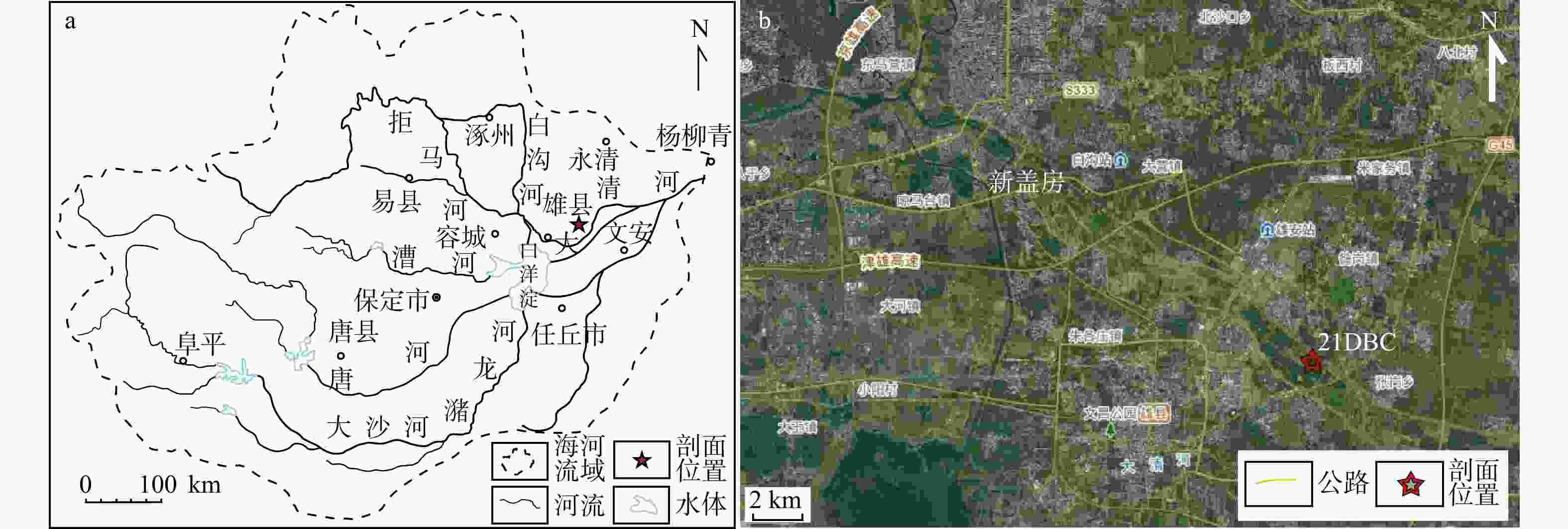
图 1 海河流域及大清河下游地理位置
a—海河流域范围;b—21DBC剖面位置
Figure 1. Haihe River Basin and the lower reaches of the Daqing River
(a) Extent of the Haihe River Basin; (b) Location of the 21DBC section
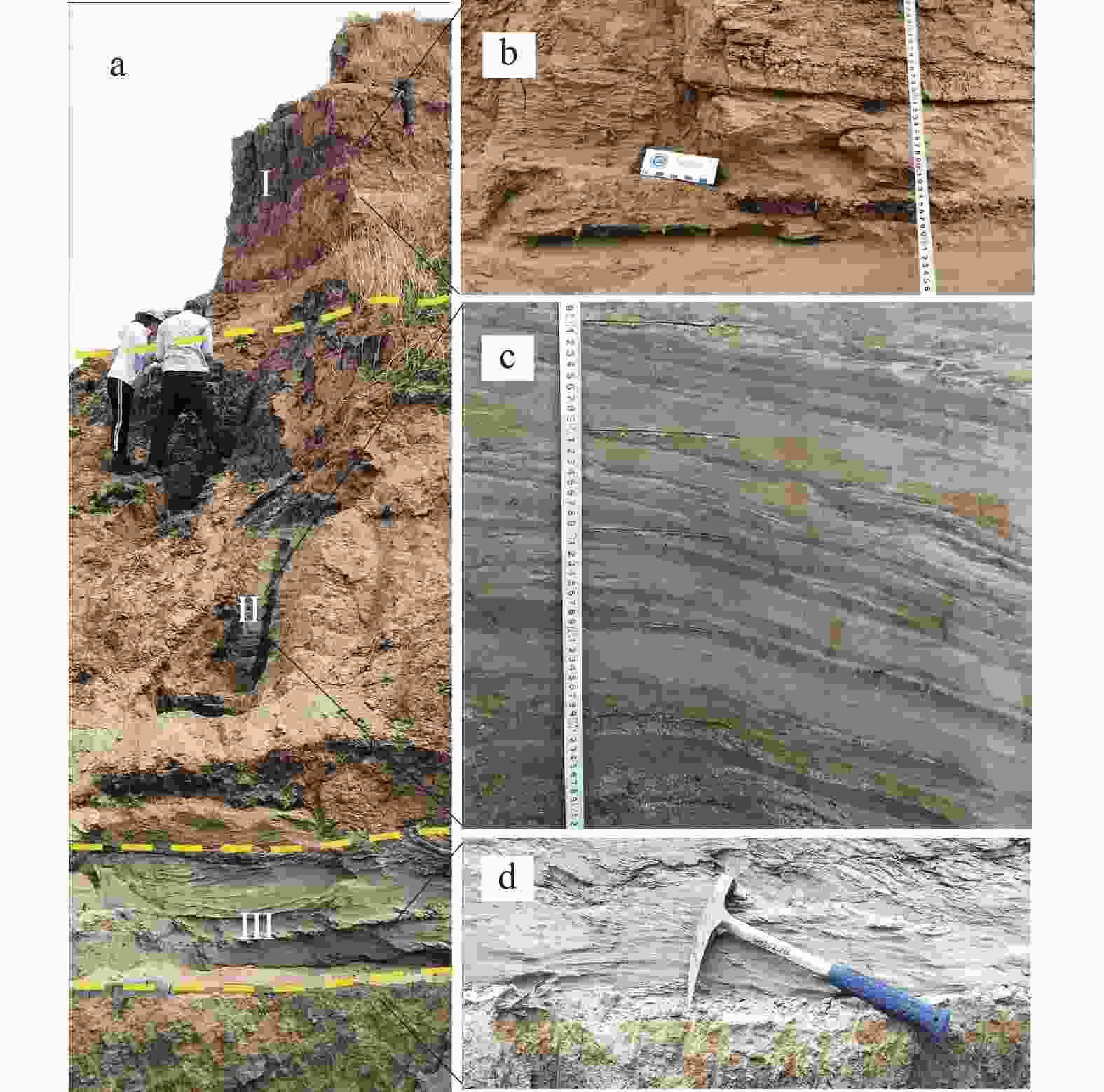
图 2 21DBC剖面沉积特征及岩性段划分
a—剖面整体岩性特征;b—上段(Ⅰ)粉细砂夹黏土质粉砂;c—中段(Ⅱ)黏土质粉砂与粉细砂互层;d—下段(Ⅲ)中—细砂
Figure 2. Sedimentary characteristics and lithologic unit division of the 21DBC section
(a) Overall lithologic characteristics of the section; (b) Upper unit (Ⅰ): silt–fine sand interbedded with clayey silt; (c) Middle unit (Ⅱ): clayey silt interbedded with silt–fine sand; (d) Lower unit (Ⅲ): medium–fine sand
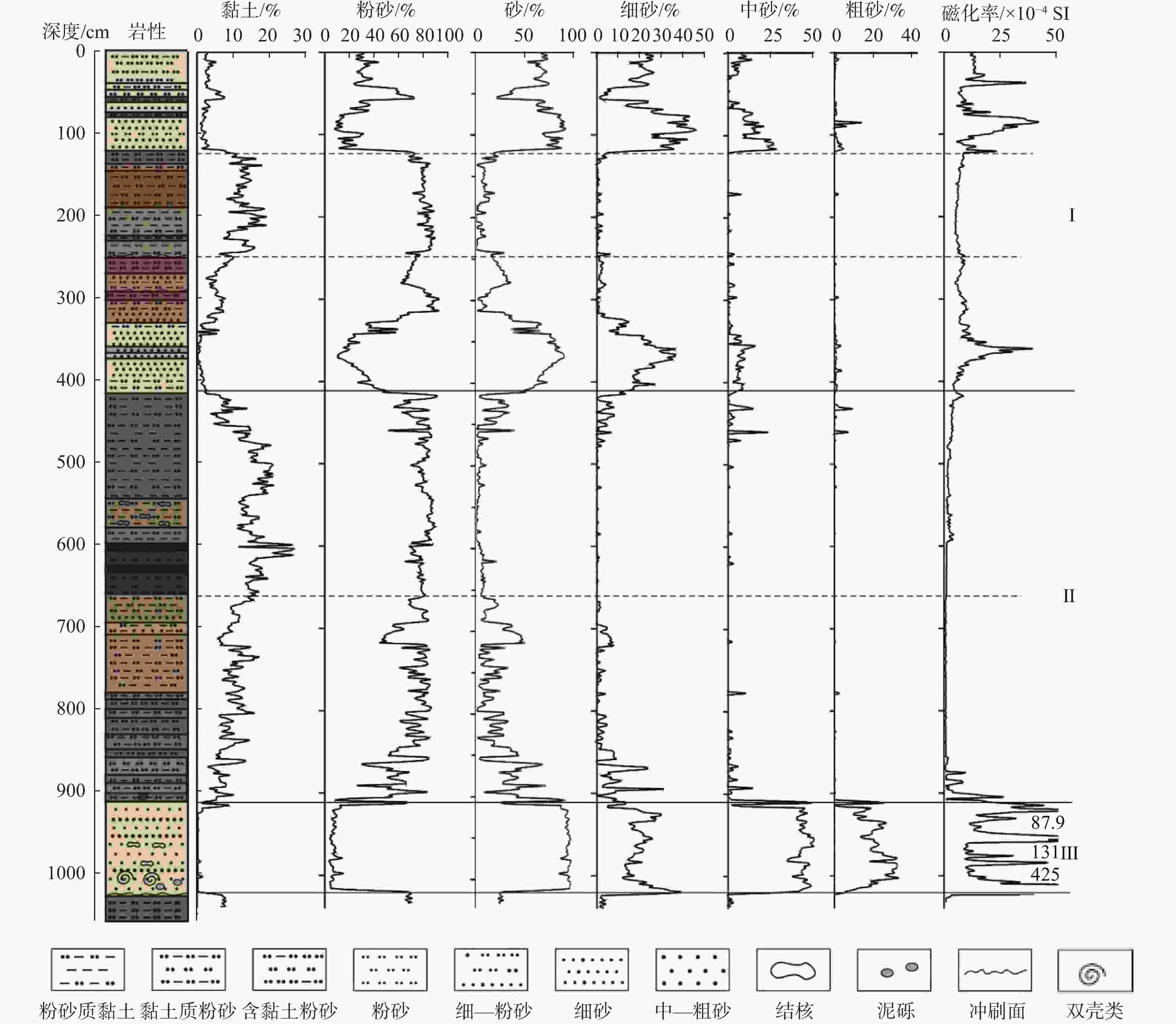
图 3 大清河北支21DBC剖面粒度组成与磁化率曲线
磁化率下段(Ⅲ)曲线中的数字表示3个异常高值(单位:10−4SI)
Figure 3. Variation of grain sizes of the 21DBC section
The numbers on the lower segment (III) of magnetic susceptibility indicate three anomaly peaks (unit: 10−4 SI).

图 4 21DBC剖面主要粒度参数变化曲线
Figure 4. Variation of main grain size parameters of the 21DBC section
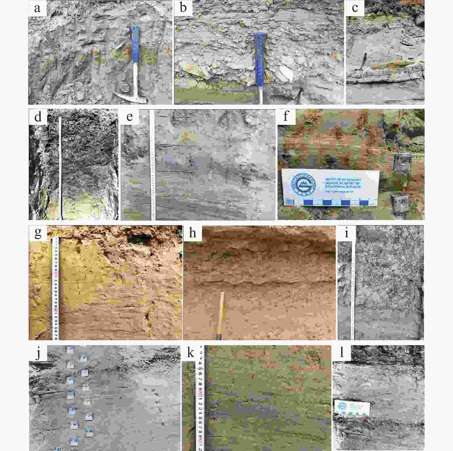
图 5 21DBC剖面典型沉积构造特征
a—剖面底部接触面;b—剖面下段含泥砾层;c—剖面下段砂层夹黏土质粉砂;d—剖面中段泥炭层;e—剖面中段灰色黏土质粉砂与黄色细砂互层;f—剖面中段纹层;g—剖面上段粉—细砂层发育小型波状层理;h—砂层底部多发育波状冲刷面;i—黏土质粉砂;j—粉—细砂层发育平行层理;k—小型波状层理;l—粉—细砂与薄层粉砂质黏土韵律层
Figure 5. Characteristics of typical sedimentary structures in the 21DBC profile
(a) Contact surface at the bottom of the section; (b) Muddy gravel layer in the lower unit of the section; (c) Sand layer interbedded with clayey silt in the lower unit of the section; (d) Peat layer in the middle unit of the section; (e) Gray clayey silt interbedded with yellow fine sand in the middle unit of the section; (f) Laminae in the middle unit of the section; (g) Small-scale wavy bedding in a silty fine sand layer in the upper unit of the section; (h) Wavy scour surfaces at the bottom of sand layers; (i) Clayey silt; (j) Parallel bedding in a silty fine sand layer; (k) Small-scale wavy bedding; (l) Rhythmic layering of silty fine sand and thin sandy clay
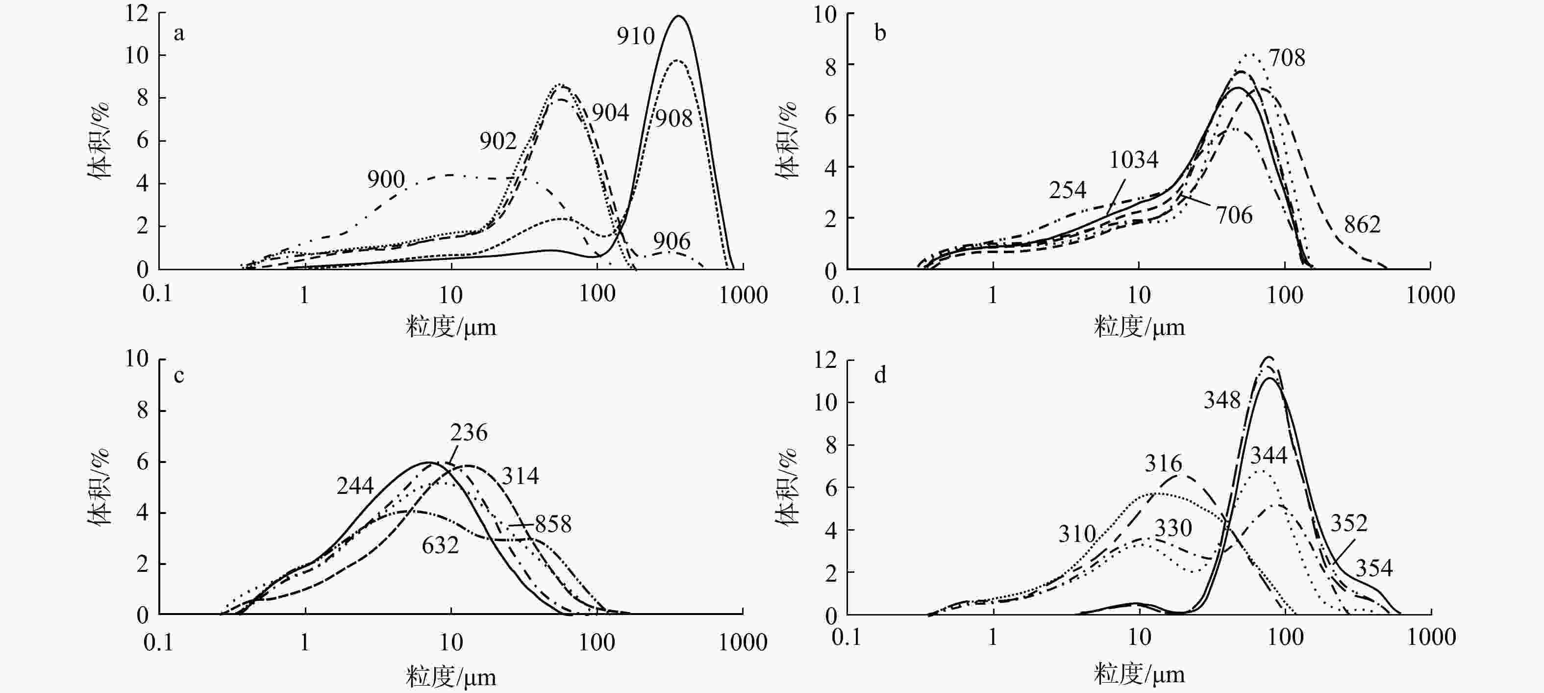
图 6 21DBC剖面典型沉积物粒度频率曲线图
a—910~900 cm深度粒度频率曲线;b—不同深度河流相沉积的粒度频率曲线;c—不同深度湖沼相沉积的粒度频率曲线;d—354~310 cm深度粒度频率曲线
Figure 6. Grain-size frequency distribution curve of typical sediments in the 21DBC section
(a) Frequency curves at 910–900 cm depth; (b) Frequency curves of fluvial deposits at different depths; (c) Frequency curves of lacustrine deposits at different depths; (d) Frequency curves at 354–310 cm depth

图 7 21DBC剖面不同深度粒度概率累积曲线
图中编号(21DBC450)为样品编号,括号中数字(910 cm)表示采样深度
Figure 7. Cumulative probability curves of different sediment types in the 21DBC section
The numbers, such as 21DBC450, in the figure represent the sample numbers, and the number in parentheses, such as 910 cm, indicates the sampling depth.
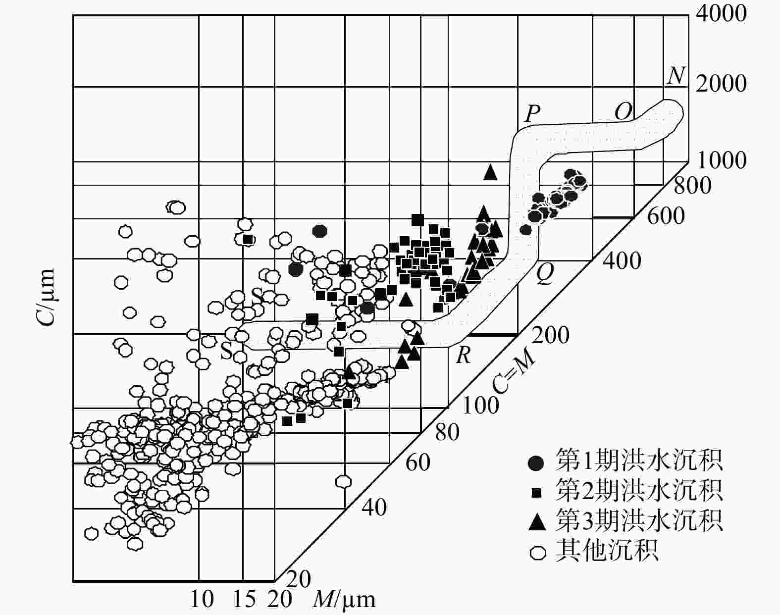
图 8 21DBC剖面沉积物粒度C-M图
NO段—滚动;OP段—滚动+悬浮;PQ段—悬浮+滚动;QR段—递变悬浮;RS段—均匀悬浮
Figure 8. C–M diagram of sediments in the 21DBC section
NO segment—rolling; OP segment—rolling with suspension; PQ segment—suspension with rolling; QR segment—graded suspension; RS segment—uniform suspension

图 9 大清河北支21DBC剖面全新世古洪水序列
a—砂含量;b—平均粒径;c—分选系数;d—磁化率(χ);e—宁晋泊年降水量(PANN;Zhang et al.,2024);f—公海年降水量(PANN;Chen et al.,2015)
Figure 9. Holocene paleoflood sequence of the 21DBC section in the Northern Branch of the Daqing River
(a) Sand content; (b) Mean grain size; (c) Sorting; (d) Magnetic susceptibility (χ); (e) Annual precipitation (PANN) of Ningjinbo (Zhang et al., 2024); (f) Annual precipitation (PANN) of Gonghai (Chen et al., 2015)
表 1 21DBC剖面AMS14C年龄测试结果(王燕校,2022)
Table 1. AMS 14C dating results for the 21DBC section (Wang, 2022)
实验室编号 样品编号 测试材料 采样深度/cm δ13C/‰ 14C年龄/a BP 2σ校正年龄/cal a BP 中值年龄/cal a BP Beta – 603450 21DBC-72 CM 沉积物 72 −21.8 3600±30 3984~3831 3907 Beta – 603451 21DBC-246 CM 沉积物 246 −21.7 4120±30 4725~4526 4625 Beta – 603452 21DBC-650 CM 沉积物 650 −23.9 4830±30 5539~5477 5508 Beta – 603453 21DBC-910 CM 沉积物 910 −22.3 7580±30 8420~8346 8383  下载: 导出CSV
表 2 21DBC剖面光释光(OSL)年龄结果(王燕校,2022)
Table 2. Optically Stimulated Luminescence (OSL) dating results for the 21DBC section (Wang, 2022)
样品编号 剖面深度/m 含水率/% U/×10−6 Th/×10−6 K/% 剂量率/(Gy/ka) 等效剂量/Gy 年龄/ka 18BZ-05 9.6 6±3 2.27±0.03 15.67±0.32 1.41±0.02 3.07±0.07 25.49±0.40 8.29±0.23 20DBC-0 10.5 23±5 2.25±0.02 10.17±0.03 1.89±0.04 3.18±0.17 130.65±2.18 41.11±2.28
下载: 导出CSV
表 3 大步村21DBC剖面沉积物粒度参数
Table 3. Grain-size parameters of the 21DBC section
地层单元 采样深度/cm 分选系数 偏度 峰态 平均粒径/µm 范围 平均 范围 平均 范围 平均 范围 平均 上段 0~120 0.97~2.16 1.45 0.03~0.52 0.34 1.02~2.04 1.58 22.30~188.30 90.46 120~250 1.41~2.54 1.83 −0.21~0.35 0.08 0.78~1.24 0.95 4.84~40.96 10.33 250~417 0.65~2.08 1.36 −0.13~0.49 0.17 0.79~1.71 1.21 10.42~122.28 56.57 中段 417~660 1.40~3.39 1.85 −0.38~0.31 0.05 0.62~1.47 0.97 4.44~32.94 8.98 660~910 1.44~2.55 1.91 0.01~0.59 0.36 0.84~2.01 1.12 7.01~87.70 23.29 下段 910~1028 0.83~1.81 1.09 0.18~0.59 0.33 1.17~1.86 1.34 21.95~387.49 281.78 底部 1028~1040 1.85~1.99 1.92 0.36~0.46 0.42 1.01~1.13 1.06 22.58~27.21 24.73
下载: 导出CSV
表 4 大步村21DBC剖面沉积物粒度参数
Table 4. Grain-size parameters of the 21DBC section
地层单元 采样深度/cm 中值粒径/µm D90/µm 砂/(粉砂+黏土)比值 砂/粉砂比值 范围 平均 范围 平均 范围 平均 范围 平均 上段 0~120 31.42~179.06 101.13 84.01~627.09 231.90 0.27~10.04 3.10 0.30~11.19 3.42 120~250 5.03~61.54 11.32 16.72~271.06 53.79 0~0.99 0.09 0~1.15 0.11 250~417 11.19~118.64 59.01 34.01~350.06 144.50 0.01~8.48 1.70 0.02~8.48 1.74 中段 417~660 4.03~41.43 9.12 18.03~601.32 57.52 0~0.63 0.07 0~0.75 0.09 660~910 8.03~113.01 31.43 26.38~309.80 87.38 0.01~2.38 0.35 0.01~2.67 0.39 下段 910~1028 27.86~403.02 315.64 114.70~756.84 600.98 0.34~25.47 13.41 0.38~25.47 13.50 底部 1028~1040 31.42~38.52 34.62 85.67~106.97 92.78 0.28~0.38 0.33 0.31~0.42 0.37
下载: 导出CSV
-
[1] AN Z S, PORTER S C, KUTZBACH J E, et al., 2000. Asynchronous Holocene optimum of the East Asian monsoon[J]. Quaternary Science Reviews, 19(8): 743-762. doi: 10.1016/S0277-3791(99)00031-1 [2] BAKER V R, 2008. Paleoflood hydrology: origin, progress, prospects[J]. Geomorphology, 101(1-2): 1-13. doi: 10.1016/j.geomorph.2008.05.016 [3] BAKER V R, BENITO G, BROWN A G, et al., 2022. Fluvial palaeohydrology in the 21st century and beyond[J]. Earth Surface Processes and Landforms, 47(1): 58-81. doi: 10.1002/esp.5275 [4] BENITO G, THORNDYCRAFT V R, 2005. Palaeoflood hydrology and its role in applied hydrological sciences[J]. Journal of Hydrology, 313(1-2): 3-15. doi: 10.1016/j.jhydrol.2005.02.002 [5] BERTOLA M, BLÖSCHL G, BOHAC M, et al., 2023. Megafloods in Europe can be anticipated from observations in hydrologically similar catchments[J]. Nature Geoscience, 16(11): 982-988. doi: 10.1038/s41561-023-01300-5 [6] BLÖSCHL G, HALL J, VIGLIONE A, et al., 2019. Changing climate both increases and decreases European river floods[J]. Nature, 573(7772): 108-111. doi: 10.1038/s41586-019-1495-6 [7] BLOTT S J, PYE K, 2001. GRADISTAT: a grain size distribution and statistics package for the analysis of unconsolidated sediments[J]. Earth Surface Processes and Landforms, 26(11): 1237-1248. doi: 10.1002/esp.261 [8] CHEN C, ZHENG Y W, ZHENG Z, et al., 2023. Holocene millennial-scale megaflood events point to ENSO-driven extreme climate changes[J]. Science China Earth Sciences, 66(11): 2530-2545. (in Chinese with English abstract) doi: 10.1007/s11430-023-1196-y [9] CHEN C J, WU Y, LI J Y, et al., 2025a. Hydrological changes in the East Asian monsoon region around 4.2 ka precisely reconstructed from multi-proxy stalagmites[J]. Quaternary Science Reviews, 357: 109321 doi: 10.1016/j.quascirev.2025.109321 [10] CHEN F H, XU Q H, CHEN J H, et al. , 2015. East Asian summer monsoon precipitation variability since the last deglaciation. Sci Rep 5, 11186 (2015). [11] CHEN H, WANG X Y, LU H Y, et al., 2024. The impacts of climate change, early agriculture and internal fluvial dynamics on paleo-flooding episodes in central China[J]. Science of the Total Environment, 954: 176431. doi: 10.1016/j.scitotenv.2024.176431 [12] CHEN P, XIAN B Z, LIU M J, et al., 2025b. Distinct grain-size patterns in sandy turbidites: implications for identifying the triggers of ancient turbidity currents in lacustrine settings[J]. Sedimentary Geology, 476: 106806. doi: 10.1016/j.sedgeo.2025.106806 [13] FAN B X, YANG B, WANG F, et al., 2025. Spatio-temporal characteristics of the 8.2 and 4.2 ka BP climate events in the East Asian summer monsoon region recorded by stalagmite δ18O data[J]. Science China Earth Sciences, 68(9): 2839-2852. (in Chinese with English abstract) doi: 10.1007/s11430-025-1621-5 [14] FOLK R L, WARD W C, 1957. Brazos River bar: a study in the significance of grain size parameters[J]. Journal of Sedimentary Petrology, 27(1): 3-26. doi: 10.1306/74D70646-2B21-11D7-8648000102C1865D [15] GAO W H, LI K F, MIAO X D, et al., 2025. Holocene extreme flood distribution patterns in the upper and middle Yellow River: a review based on slackwater deposits[J]. Earth-Science Reviews, 261: 105039. doi: 10.1016/j.earscirev.2024.105039 [16] GUO Y Q, GE Y G, CHEN X Q, et al., 2021. Progress in the reconstruction of palaeoflood events in the mountain canyon valleys around the Tibetan Plateau[J]. Earth Science Frontiers, 28(2): 168-180. (in Chinese with English abstract) [17] HAO Z X, XIONG D Y, GE Q S, 2018. Reconstruction of the chronology and characteristics of flood disasters in the Xiong'an New Area over the last 300 years[J]. Chinese Science Bulletin, 63(22): 2302-2310. (in Chinese with English abstract) doi: 10.1360/N972018-00068 [18] HARDENG J, BAKKE J, SABATIER P, et al., 2022. Lake sediments from southern Norway capture Holocene variations in flood seasonality[J]. Quaternary Science Reviews, 290: 107643. doi: 10.1016/j.quascirev.2022.107643 [19] Hebei Provincial Water Resources Department Water Conservancy Annals Editorial Office, 1996. Hebei water conservancy annals[M]. Shijiazhuang: Hebei People's Publishing House. (in Chinese) [20] HUANG C C, ZHA X C, LI Y Q, et al., 2025. Progress and prospect of the Holocene palaeoflood hydrology in the middle-upper reaches of the Huaihe River Basin[J]. Geographical Science, 45(1): 36-46. (in Chinese with English abstract) [21] Institute of Regional Geological and Mineral Survey of Hebei Province, 2017. Regional geology of China-Hebei Province[M]. Beijing: Geological Publishing House. (in Chinese) [22] KOCHEL R C, BAKER V R, 1982. Paleoflood hydrology[J]. Science, 215(4531): 353-361. doi: 10.1126/science.215.4531.353 [23] LI H Y, ZHAO N, YANG Y P, et al., 2022. Sedimentary characterization and provenance analysis of the 2018 flooding along the Dan River, Shandong, and the hydrodynamic process reconstruction[J]. Journal of Geomechanics, 28(2): 226-236. (in Chinese with English abstract) [24] LI X C, ZHANG Y X, LI W, et al., 2023. Extreme characteristics of "23·7" heavy rain in Beijing-Tianjin-Hebei and its implications for urban flood control in China[J]. China Flood & Drought Management, 33(11): 13-18. (in Chinese with English abstract) [25] LIN H M, MIN J Z, ZHU L J, et al., 2023. The role of Taihang Mountain topography in“7·19”persistent low vortex rainstorm in North China[J]. Journal of the Meteorological Sciences, 43(1): 46-58. (in Chinese with English abstract) [26] LIU J, WANG H, CHEN L L, et al., 2025. Abrupt sea-level rise prior to the 8.2 ka climatic event revealed from the post-glacial sedimentary succession off the northern coast of Shandong Peninsula, North Yellow Sea[J]. Quaternary Science Reviews, 363: 109428. doi: 10.1016/j.quascirev.2025.109428 [27] LIU J L, LI Y, SHI X, et al., 2017. Grain size characteristics and distribution regularities of typical river sediments in Haihe River Basin[J]. Water Resources Protection, 33(6): 9-19. (in Chinese with English abstract) [28] LIU Z R, XUE H Y, WANG C S, 2021. Late Quaternary depositional characteristics and environment significance of the Xibozhang section in Baoding, central Hebei Plain, China[J]. Journal of Geomechanics, 27(6): 1011-1023. (in Chinese with English abstract) [29] MA Q, TU Z H, LI Z M, et al. , 2025. Future flood defense condition with the rain belt northward moving in Daqing River basin[J/OL]. South-to-North Water Transfers and Water Science & Technology. [2025-09-10]. https://link.cnki.net/urlid/13.1430.tv.20250703.1805.006. (in Chinese with English abstract) [30] MAIZELS J, 1997. Jökulhlaup deposits in proglacial areas[J]. Quaternary Science Reviews, 16(7): 793-819. doi: 10.1016/S0277-3791(97)00023-1 [31] MILLY P C D, WETHERALD R T, DUNNE K A, et al., 2002. Increasing risk of great floods in a changing climate[J]. Nature, 415(6871): 514-517. doi: 10.1038/415514a [32] NI H T, TIAN F, HUAN X J, et al., 2025. Authenticity of the Great Flood during the late Longshan era[J]. Journal of Geographical Sciences, 35(8): 1714-1732. doi: 10.1007/s11442-025-2391-7 [33] OLDFIELD F, 1991. Environmental magnetism — a personal perspective[J]. Quaternary Science Reviews, 10(1): 73-85. doi: 10.1016/0277-3791(91)90031-O [34] OSTROWSKI P, FALKOWSKI T, KOCHANEK K, 2023. Reconstructing parameters of the Holocene paleofloods in alluvial lowland river valleys – an example from the Bug valley (East Poland)[J]. Journal of Hydrology, 624: 129930. doi: 10.1016/j.jhydrol.2023.129930 [35] PASSEGA R, 1957. Texture as characteristic of clastic deposition[J]. AAPG Bulletin, 41(9): 1952-1984. [36] QU X X, HUANG C, RAO Z G, et al., 2024. Holocene provenance variations and palaeofloods response to ENSO-driven monsoon precipitation in the subalpine peatland in southern China[J]. Palaeogeography, Palaeoclimatology, Palaeoecology, 635: 111948. doi: 10.1016/j.palaeo.2023.111948 [37] REIMER P J, AUSTIN W E N, BARD E, et al., 2020. The IntCal20 Northern Hemisphere radiocarbon age calibration curve (0-55 cal kBP)[J]. Radiocarbon, 62(4): 725-757. doi: 10.1017/RDC.2020.41 [38] SHANG L J, ZHA X C, HUANG C C, et al., 2024. Late Holocene extraordinary palaeoflood events and their climatological context in the Shahe River, Huaihe River Basin, China[J]. Journal of Asian Earth Sciences, 276: 106346. doi: 10.1016/j.jseaes.2024.106346 [39] SHENG G Y, LIAO Y M, HU H B, 2020. Risk evaluation for flood waterlogging disasters in the Xiongan New Area under climate change[J]. China Population, Resources and Environment, 30(6): 40-52. (in Chinese with English abstract) [40] SHI C Y, 2012. A study on migration of the Southern branches of the Daqinghe river in historical periods: and on its relationship with the evolution of the Baiyangdian lake[J]. Journal of Chinese historical Geography, 27(2): 50-59. (in Chinese with English abstract) [41] STØREN E N, DAHL S O, NESJE A, et al., 2010. Identifying the sedimentary imprint of high-frequency Holocene river floods in lake sediments: development and application of a new method[J]. Quaternary Science Reviews, 29(23-24): 3021-3033. doi: 10.1016/j.quascirev.2010.06.038 [42] SUN T, CHENG W Q, BO Q Y, et al., 2021. Analysis on historical flood and countermeasures in prevention and control of flood in Daqing River Basin[J]. Environmental Research, 196: 110895. doi: 10.1016/j.envres.2021.110895 [43] WANG H Y, JIA Y N, ZHANG Y Z, et al., 2021. Research progress of paleoflood events in the Yellow River Basin since the Last Deglaciation[J]. Progress in Geography, 40(7): 1220-1234. (in Chinese with English abstract) doi: 10.18306/dlkxjz.2021.07.012 [44] WANG Y J, CHENG H, EDWARDS R L, et al., 2005. The Holocene Asian monsoon: links to solar changes and north Atlantic climate[J]. Science, 308(5723): 854-857. doi: 10.1126/science.1106296 [45] WANG Y J, 2022. Paleoflood events recorded by Holocene fluvial sediments in Baiyangdian[D]. Beijing: Chinese Academy of Geological Sciences. [46] WEISS H, COURTY M A, WETTERSTROM W, et al., 1993. The genesis and collapse of third millennium north Mesopotamian civilization[J]. Science, 261(5124): 995-1004. doi: 10.1126/science.261.5124.995 [47] WEN Y W, LI Y Q, HUANG C C, et al., 2025. Sedimentary characteristics and hydroclimatic background of palaeoflood events since the Late Pleistocene in the Lihe River, a tributary of the Huaihe River[J]. Progress in Geography, 44(3): 642-656. (in Chinese with English abstract) doi: 10.18306/dlkxjz.2025.03.015 [48] WENTWORTH C K, 1922. A scale of grade and class terms for clastic sediments[J]. The Journal of Geology, 30(5): 377-392. doi: 10.1086/622910 [49] WILHELM B, ARNAUD F, ENTERS D, et al., 2012. Does global warming favour the occurrence of extreme floods in European Alps? First evidences from a NW Alps proglacial lake sediment record[J]. Climatic Change, 113(3-4): 563-581. doi: 10.1007/s10584-011-0376-2 [50] WILHELM B, BALLESTEROS CÁNOVAS J A, MACDONALD N, et al., 2019. Interpreting historical, botanical, and geological evidence to aid preparations for future floods[J]. WIREs Water, 6(1): e1318. doi: 10.1002/wat2.1318 [51] XU R Z, YU S Y, ZHOU L, et al., 2025. Holocene extreme flood events in the Yangtze River Basin: research progress and implications[J]. Marine Geology & Quaternary Geology, 45(2): 158-176. (in Chinese with English abstract) [52] YANG J S, WANG Y, YIN J H, et al., 2022. Progress and prospects in reconstruction of flood events in Chinese alluvial plains[J]. Earth Science, 47(11): 3944-3959. (in Chinese with English abstract) [53] YANG J S, LIU Z, LIU S H, et al., 2025. Holocene paleoflood stratigraphy in the lower Yellow River floodplain, China[J]. Geomorphology, 478: 109720. doi: 10.1016/j.geomorph.2025.109720 [54] YANG X L, JIN X Q, SUN Y, et al., 2023. Evolution characteristics and formation of the July 2023 severe torrential rain on the eastern foothills of Taihang Mountains in Hebei Province[J]. Meteorological Monthly, 49(12): 1451-1467. (in Chinese with English abstract) [55] YIN C M, QIU W L, LI R Q, 2001. Holocene paleofloods in the North China Plain[J]. Journal of Beijing Normal University (Natural Science), 37(2): 280-284. (in Chinese with English abstract) [56] YU S Y, HOU Z F, CHEN X X, et al., 2020. Extreme flooding of the lower Yellow River near the Northgrippian-Meghalayan boundary: evidence from the Shilipu archaeological site in southwestern Shandong Province, China[J]. Geomorphology, 350: 106878. doi: 10.1016/j.geomorph.2019.106878 [57] YU S Y, LI W J, ZHOU L, et al., 2023. Human disturbances dominated the unprecedentedly high frequency of Yellow River flood over the last millennium[J]. Science Advances, 9(8): eadf8576. doi: 10.1126/sciadv.adf8576 [58] ZAVALA C, PAN S X, 2018. Hyperpycnal flows and hyperpycnites: origin and distinctive characteristics[J]. Lithologic Reservoirs, 30(1): 1-18. [59] ZHA X C, HUANG C C, PANG J L, et al. , 2015. Reconstructing the palaeoflood events from slackwater deposits in the upper reaches of Hanjiang River, China[J]. Quaternary International, 380-381: 358-367. [60] ZHANG P, YANG J S, ZHAO H, et al., 2020. Research progress of the Holocene paleoflood in the Yellow River basin and a future prospect[J]. Marine Geology & Quaternary Geology, 40(6): 178-188. (in Chinese with English abstract) [61] ZHANG W S, LI B, FAN B S, et al., 2024. Reconstruction of Holocene precipitation patterns and vegetation evolution in the North China Plain: deciphering the relative influence of climate and anthropogenic forcing[J]. Palaeogeography, Palaeoclimatology, Palaeoecology, 638: 112020. doi: 10.1016/j.palaeo.2024.112020 [62] ZHANG X M, ZHANG H W, ZHANG R, et al., 2025. Spatiotemporal pattern of the East Asian monsoon hydroclimate during the 8.2 ka event inferred from a new speleothem multi-proxy record from SE China[J]. Quaternary Science Reviews, 349: 109141. doi: 10.1016/j.quascirev.2024.109141 [63] ZHANG Y C, MA Z J, GAO Q H, et al., 2006. Huge disaster risk and prevention in China[J]. Journal of Geomechanics, 12(2): 119-126. (in Chinese with English abstract) [64] ZHANG Y Z, HUANG C C, PANG J L, et al., 2013. Holocene paleofloods related to climatic events in the upper reaches of the Hanjiang River valley, middle Yangtze River basin, China[J]. Geomorphology, 195: 1-12. doi: 10.1016/j.geomorph.2013.03.032 [65] 陈聪, 郑艳伟, 郑卓, 等, 2023. 全新世千年尺度大洪水沉积记录与ENSO驱动的极端气候变化[J]. 中国科学: 地球科学, 53(11): 2575-2590. [66] 樊倍希, 杨保, 王丰, 等, 2025. 基于东亚季风区石笋δ18O记录的8.2和4.2ka BP气候事件的时空特征研究[J]. 中国科学: 地球科学, 55(9): 2962-2976. [67] 郭永强, 葛永刚, 陈晓清, 等, 2021. 高山峡谷区古洪水事件重建研究进展[J]. 地学前缘, 28(2): 168-180. [68] 郝志新, 熊丹阳, 葛全胜, 2018. 过去300年雄安新区涝灾年表重建及特征分析[J]. 科学通报, 63(22): 2302-2310. [69] 河北省区域地质矿产调查研究所, 2017. 中国区域地质志-河北志[M]. 北京: 地质出版社. [70] 河北省水利厅水利志编辑办公室, 1996. 河北省水利志[M]. 石家庄: 河北人民出版社. [71] 黄春长, 查小春, 李瑜琴, 等, 2025. 淮河中上游流域全新世古洪水水文学研究进展与展望[J]. 地理科学, 45(1): 36-46. [72] 李华勇, 赵楠, 杨艺萍, 等, 2022. 山东丹河2018年洪水沉积特征、物源分析及水文过程重建[J]. 地质力学学报, 28(2): 226-236. [73] 李修仓, 张颖娴, 李威, 等, 2023. “23·7”京津冀暴雨极端性特征及对我国城市防汛的启示[J]. 中国防汛抗旱, 33(11): 13-18. [74] 林慧敏, 闵锦忠, 朱利剑, 等, 2023. 太行山地形在“7·19”华北持续性低涡暴雨中的作用[J]. 气象科学, 43(1): 46-58. [75] 刘静玲, 李毅, 史璇, 等, 2017. 海河流域典型河流沉积物粒度特征及分布规律[J]. 水资源保护, 33(6): 9-19. [76] 刘智荣, 薛怀宇, 王昌盛, 2021. 河北平原中部保定西伯章剖面晚第四纪沉积特征及其环境意义[J]. 地质力学学报, 27(6): 1011-1023. [77] 马强, 涂泽辉, 李郑淼, 等, 2025. 雨带北移影响下大清河北支防洪情势[J/OL]. 南水北调与水利科技. [2025-09-10]. https: //link.cnki.net/urlid/13.1430.tv.20250703.1805.006. [78] 盛广耀, 廖要明, 扈海波, 2020. 气候变化下雄安新区洪涝灾害的风险评估及适应措施[J]. 中国人口·资源与环境, 30(6): 40-52. [79] 石超艺, 2012. 历史时期大清河南系的变迁研究: 兼谈与白洋淀湖群的演变关系[J]. 中国历史地理论丛, 27(2): 50-59. [80] 王浩宇, 贾雅娜, 张玉柱, 等, 2021. 黄河流域末次冰消期以来古洪水事件研究进展[J]. 地理科学进展, 40(7): 1220-1234. [81] 王燕校, 2022. 白洋淀全新世河流相沉积记录的古洪水事件[D]. 北京: 中国地质科学院. [82] 温煜未, 李瑜琴, 黄春长, 等, 2025. 淮河支流澧河晚更新世以来古洪水事件沉积特征及其水文气候背景[J]. 地理科学进展, 44(3): 642-656. [83] 徐润喆, 于世永, 周亮, 等, 2025. 长江流域全新世极端洪水事件研究进展与启示[J]. 海洋地质与第四纪地质, 45(2): 158-176. [84] 杨劲松, 王永, 尹金辉, 等, 2022. 我国冲积平原区洪水事件重建研究进展及展望[J]. 地球科学, 47(11): 3944-3959. [85] 杨晓亮, 金晓青, 孙云, 等, 2023. “23·7”河北太行山东麓罕见特大暴雨特征及成因[J]. 气象, 49(12): 1451-1467. [86] 殷春敏, 邱维理, 李容全, 2001. 全新世华北平原古洪水[J]. 北京师范大学学报(自然科学版), 37(2): 280-284. [87] 张鹏, 杨劲松, 赵华, 等, 2020. 黄河流域全新世古洪水研究进展及展望[J]. 海洋地质与第四纪地质, 40(6): 178-188. [88] 张业成, 马宗晋, 高庆华, 等, 2006. 中国的巨灾风险与巨灾防范[J]. 地质力学学报, 12(2): 119-126. -

 下载:
下载:


计量
- 文章访问数: 403
- HTML全文浏览量: 154
- PDF下载量: 52
- 被引次数: 0
