

Drainage characteristics of the Noto Peninsula, Japan, and their implications for seismic hazards
-
摘要: 2024年1月1日,日本石川县能登半岛发生了Mw 7.5地震,造成200多人死亡。强烈的地壳变形、海啸和滑坡对该地区造成了广泛破坏。历史上,该地区曾多次发生破坏性地震,并诱发滑坡等地质灾害。因此,准确评估该区域主要断裂带的构造活动性具有重要的现实意义和紧迫性。文章尝试采用流域地貌定量分析方法,探讨该地区的活动构造变形特征及其对潜在地震灾害风险的影响。基于30 m空间分辨率的ASTER GDEM数据,提取了研究区的主要流域河网,并获取了(亚)流域盆地的坡度、起伏度、面积−高程积分(HI)和归一化河道陡峭指数(ksn)等地貌参数,同时评估了流域分水岭的稳定性。在此基础上,结合震后发布的航拍影像及地震滑坡解译数据,分析了地震滑坡对分水岭的影响。通过对比分析流域盆地的地形坡度、起伏度、HI值和ksn值发现,半岛北部沿海地区经历了显著的构造活动变形,且表现出明显的分段性特征。2024年能登地震中2个地表抬升显著的区域正位于该地带。半岛中南部也识别出较强的构造活动区域,其空间分布与地表断裂带高度一致。这些断裂带的构造活动性及其潜在的地震灾害风险应引起高度重视。地震滑坡主要集中在地震高抬升区、流域分水岭及河道附近的陡坡地带,表现出高地形坡度和高ksn值特征。部分滑坡甚至跨越分水岭,影响了流域盆地的整体形态。研究结果为进一步评估能登半岛未来潜在的地震灾害提供了重要的科学依据。Abstract:
Objective On January 1, 2024, a Mw 7.5 earthquake occurred on the Noto Peninsula in Ishikawa Prefecture, Japan, resulting in more than 200 fatalities. The seismic event triggered significant crustal deformation, tsunamis, and landslides, leading to widespread damage across the region. Historically, this area has been prone to destructive earthquakes and associated geological hazards, such as landslides. Therefore, accurately evaluating the tectonic activity of major fault zones in the region is both critically important and urgently needed. Methods This study aims to employ quantitative morphotectonic analysis of drainage landscape to investigate the characteristics of active tectonic deformation and its implications for potential seismic hazards. Based on ASTER GDEM data with a spatial resolution of 30 meters, the drainage network within the study area was delineated. Geomorphic indices, including slope, relief, hypsometrical integral (HI), and normalized channel steepness index (ksn), were calculated for each (sub)watershed basin. Additionally, the stability of drainage divides was assessed. Using this information, and integrating post-earthquake aerial imagery and landslide interpretation data, the influence of earthquake-induced landslides on drainage divides was analyzed. Results Comparative analysis of topographic slope, relief, HI, and ksn values revealed that the northern coastal region of the peninsula has undergone significant tectonic deformation, exhibiting distinct segmentation characteristics. As well, active tectonic zones were identified in the central and southern parts of the peninsula, with spatial distributions closely aligned with known surface fault zones. Earthquake-induced landslides were predominantly concentrated in areas of high uplift, along drainage divides, and on steep slopes adjacent to river channels, characterized by steep topography and elevated ksn values. Some landslides even crossed the divides, thereby altering the overall morphology of the drainage basins. Conclusion As revealed by our geomorphological analysis, the northern regions exhibiting high tectonic activity are consistent with areas that experienced significant surface uplift during the 2024 Noto earthquake. Moreover, the central and southern regions, which are characterized by ongoing active deformation, also require careful assessment of their seismic hazards. Significance The findings of this study provide a crucial scientific basis for evaluating future seismic risk in the Noto Peninsula. -
Key words:
- Noto Peninsula /
- geomorphic indices /
- seismic hazards /
- co-seismic landslides /
- drainage divide
-
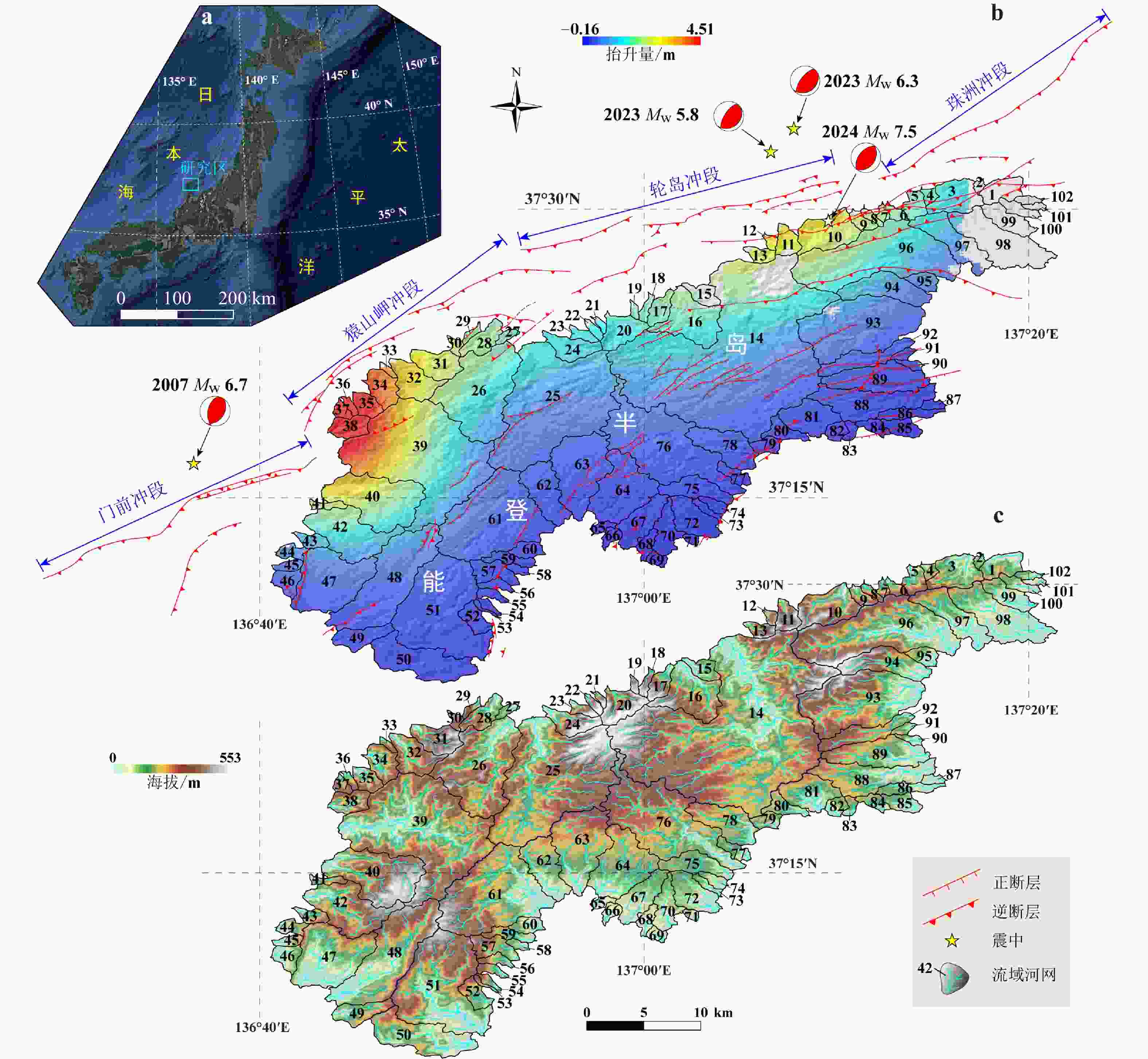
图 1 日本能登半岛区域地质背景、地貌特征及震源机制解(活动断裂的分布引自Inoue et al.,2010;同震地表抬升量结果据 Ma et al.,2024)
a—日本能登半岛地理位置;b—2024年MW 7.5地震引起的同震地表抬升;c—研究区流域河网分布
Figure 1. Regional geological background, geomorphic features and focal mechanism solutions of the Noto Peninsula, Japan(Distribution of active faults is soured from Inoue et al.,2010;Co-seismic uplift amounts are based on Ma et al.,2024)
(a) The geographical location of the Noto Peninsula, Japan; (b) Co-seismic uplift associated with the Mw 7.5 earthquake in 2024; (c) Drainage network distribution within the study area
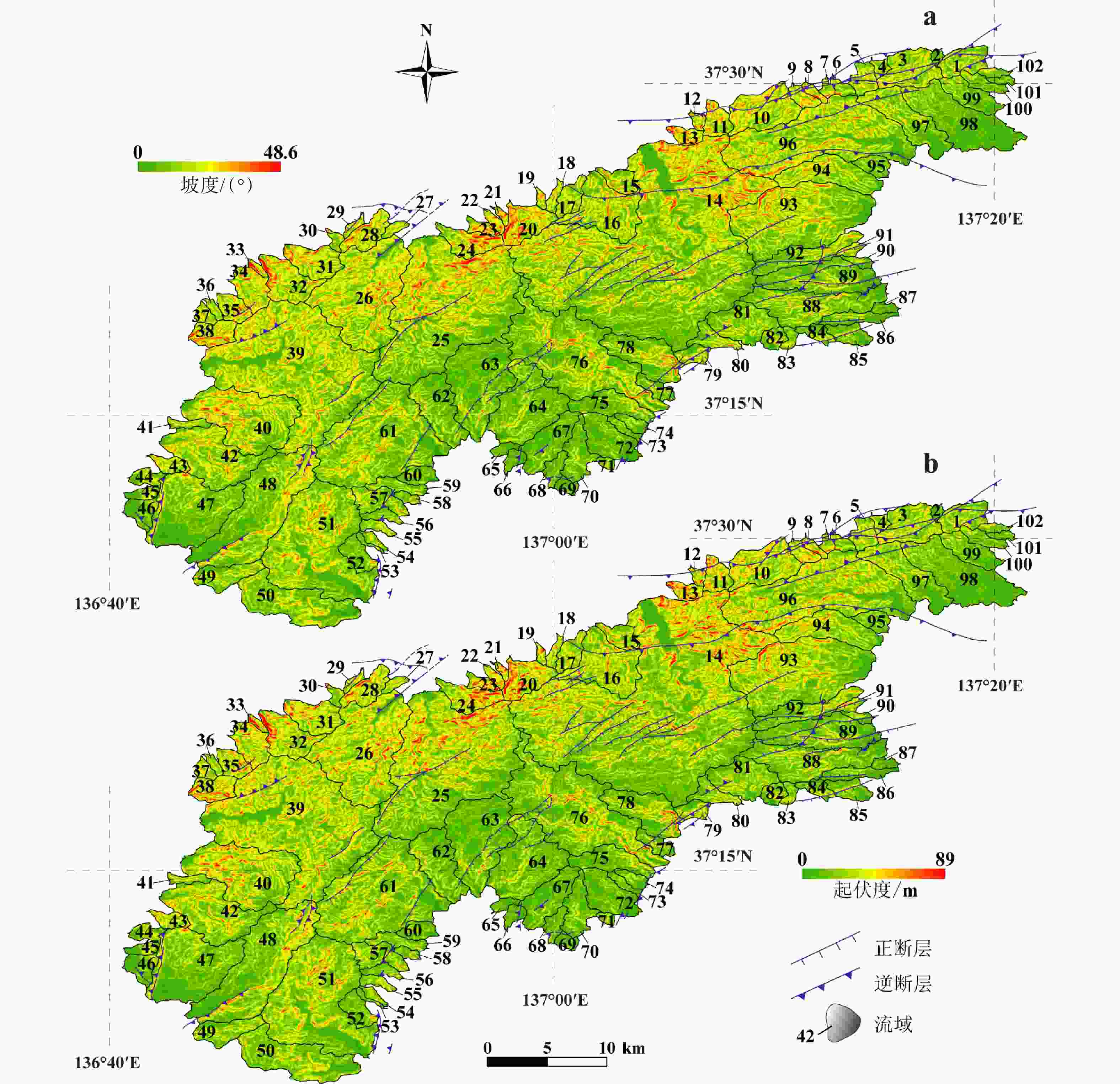
图 2 日本能登半岛地形坡度和起伏平面分布图
a—地形坡度图;b—地形起伏度图
Figure 2. Topographic gradient and relief map of the Noto Peninsula, Japan
(a) Topographic gradient map;(b) Topographic relief map
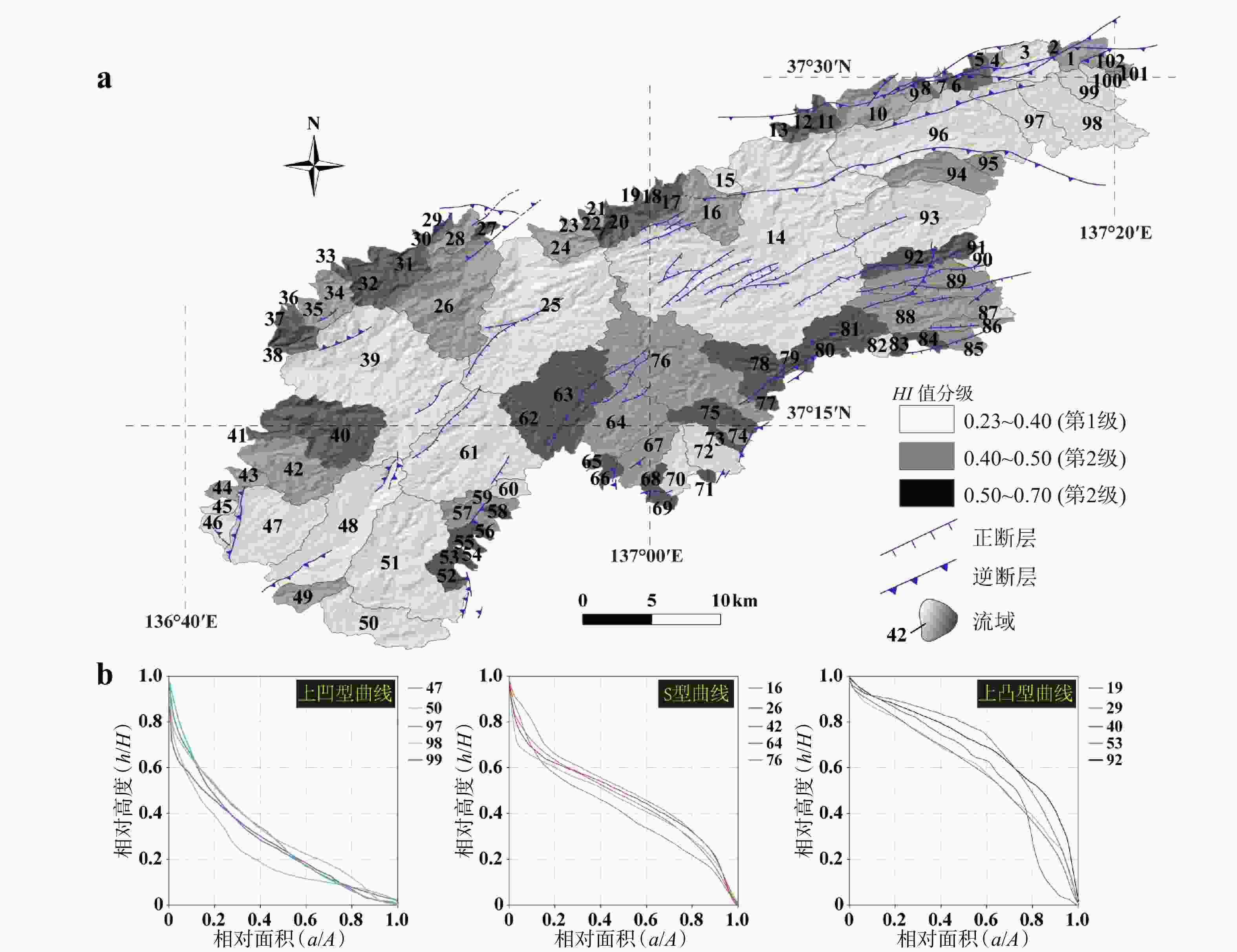
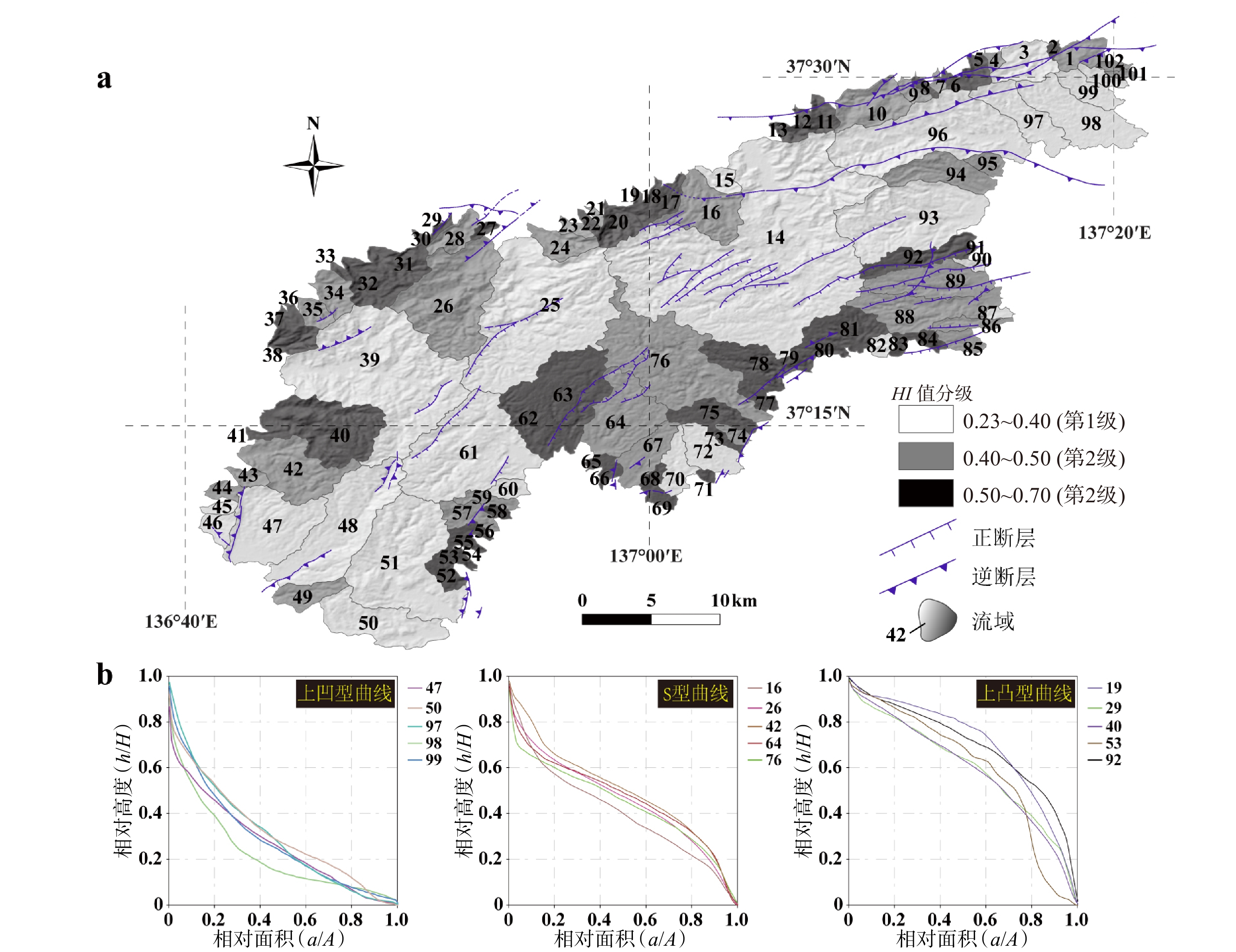
图 3 研究区流域盆地HI值分级及代表性曲线图
a—HI值分级图;b—上凹型、S型和下凹型3种代表性面积−高程积分曲线图
Figure 3. Classification of HI values and representative hypsometric curves for the drainage basins within the study area
(a) Classified HI values; (b) Representative hypsometric curves with upwardly convex, S-shaped and upwardly concave geometries
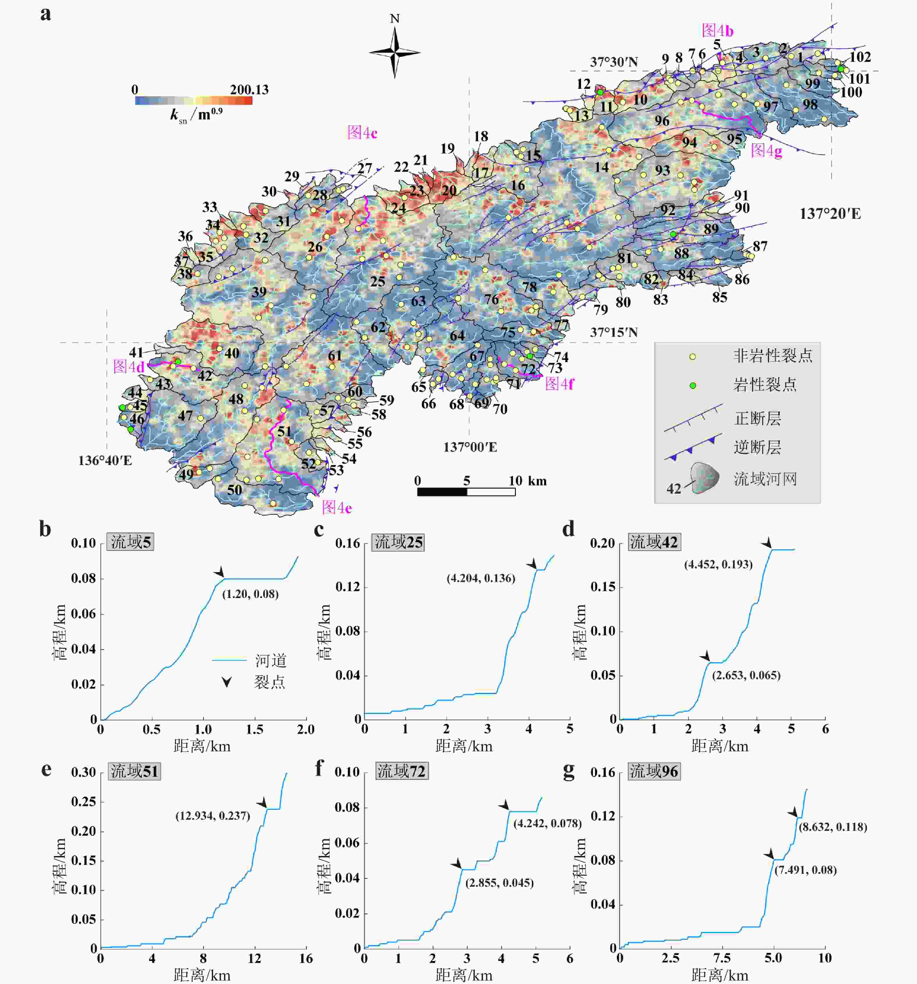
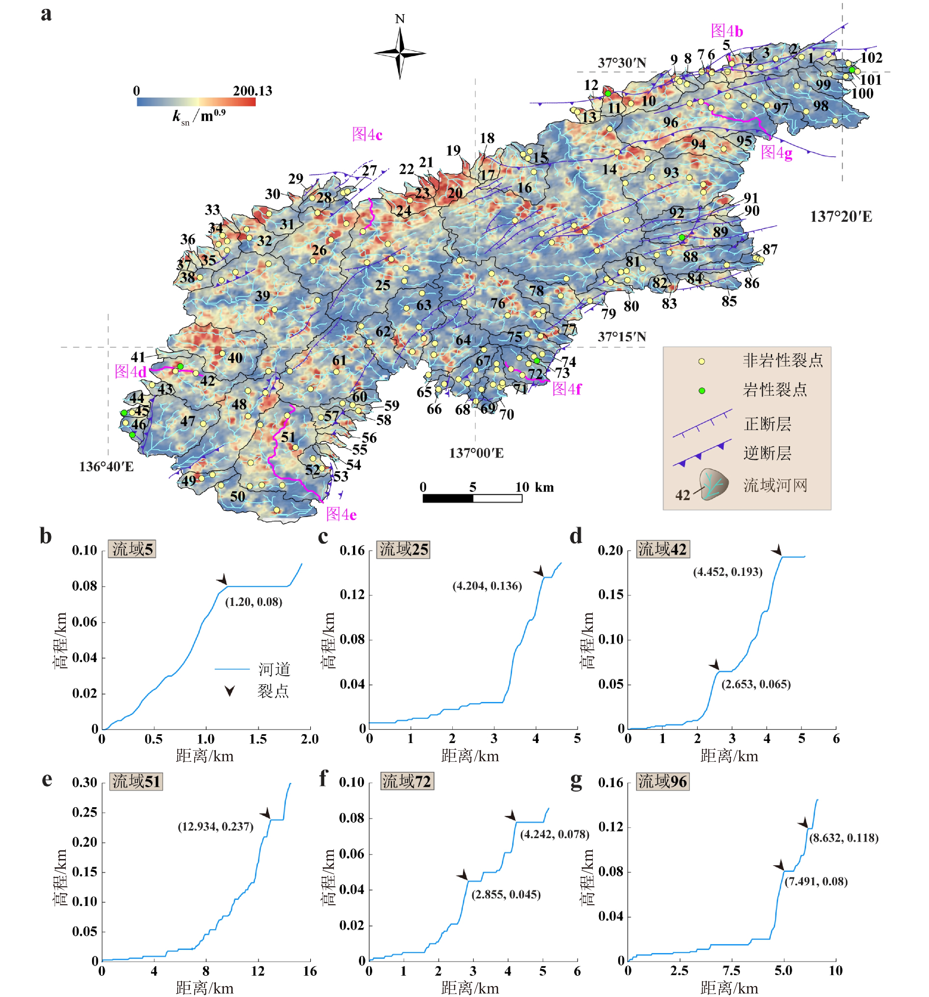
图 4 ksn分布图及代表性河道剖面上识别的裂点
a—ksn插值与裂点空间分布图;b—g代表性河道剖面及裂点示意图
Figure 4. The ksn map and knickpoints identified from the representative river long-profiles
(a) The interpolated ksn map with identified knickpoints; (b−g) Representative river long-profiles exhibiting knickpoints
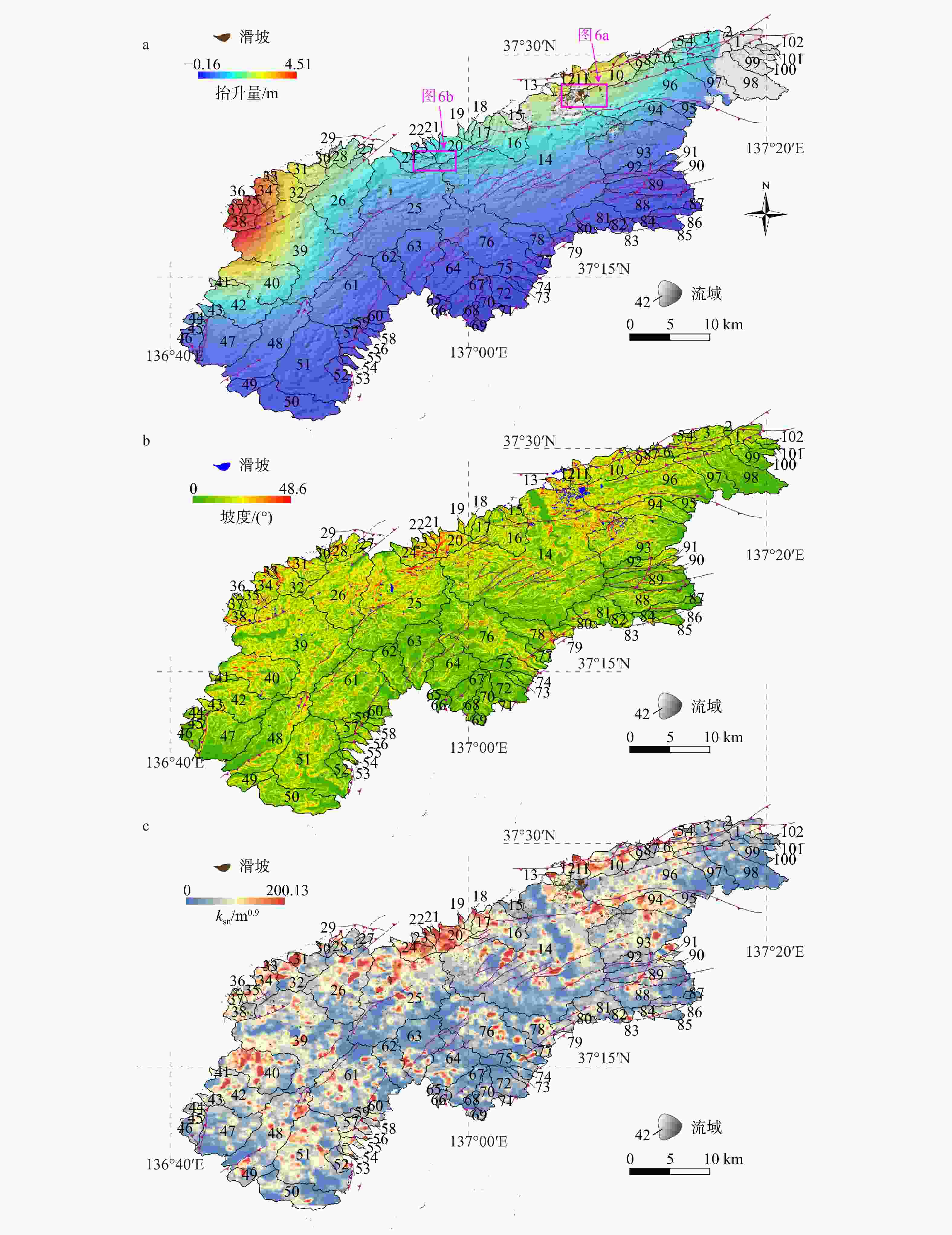
图 5 地震滑坡分布特征和抬升样式及其与地形因子的对比
a—地震滑坡分布特征和地表抬升样式;b—地震滑坡与地形坡度;c—地震滑坡与插值的ksn
Figure 5. Characteristics of the co-seismic landslide distribution and uplift patterns, and their correlation with topographic metrics
(a) Co-seismic landslide distribution and uplift patterns; (b) Distribution of co-seismic landslides and slope gradient; (c) Distribution of co-seismic landsides and interpolated ksn values

图 6 航拍影像解译得到的代表性地震滑坡(位置见图6a)
a—流域14内主要滑坡分布图;b—流域24内主要滑坡分布图
Figure 6. Representative landslides identified through the analysis of aerial images (The locations are shown in Fig. 6a)
(a) Co-seismic landslides within the drainage basin 14; (b) Co-seismic landslides within the drainage basin 24

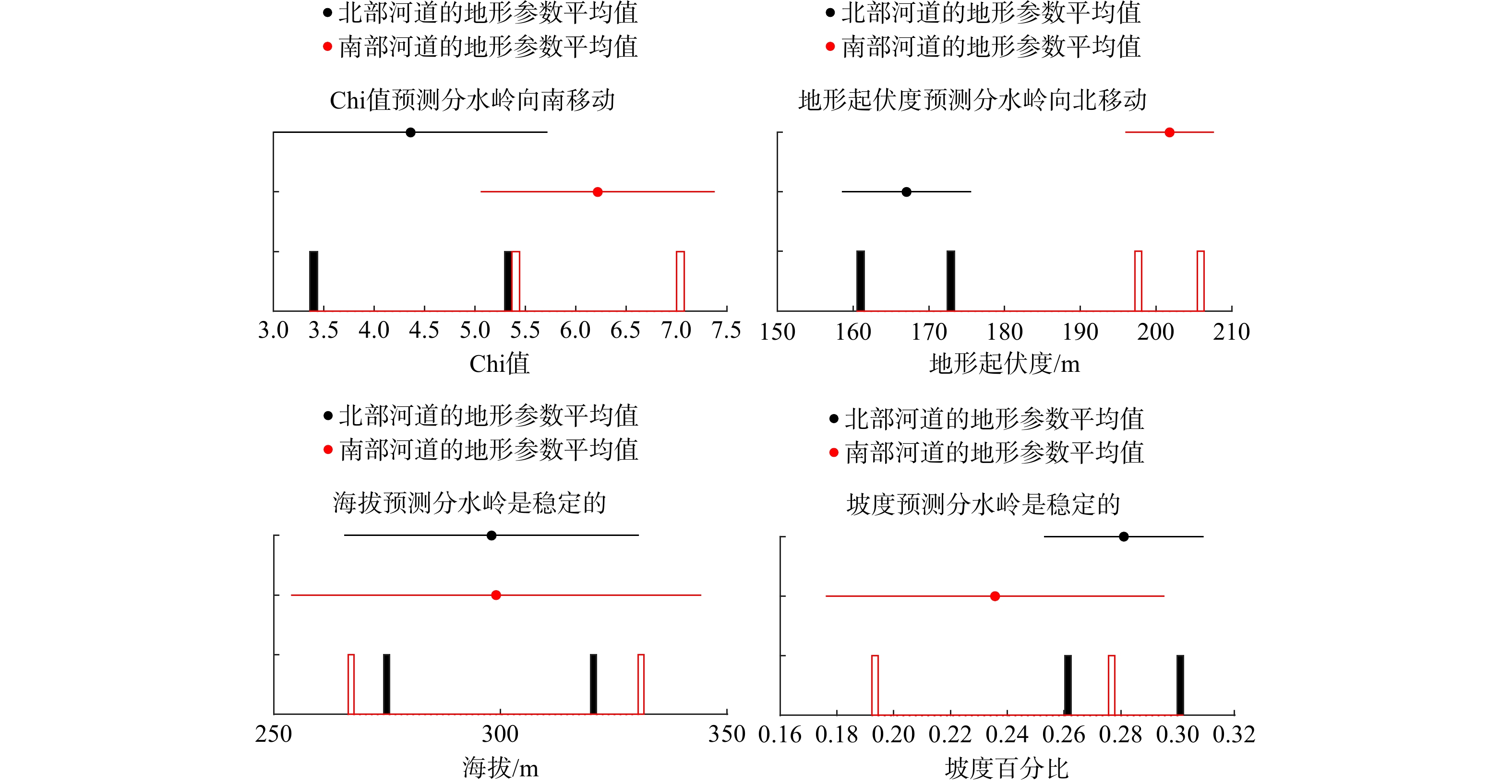
图 7 基于Chi值推断的主分水岭迁移方向
Figure 7. The migration direction of the main drainage divide predicted by χ values
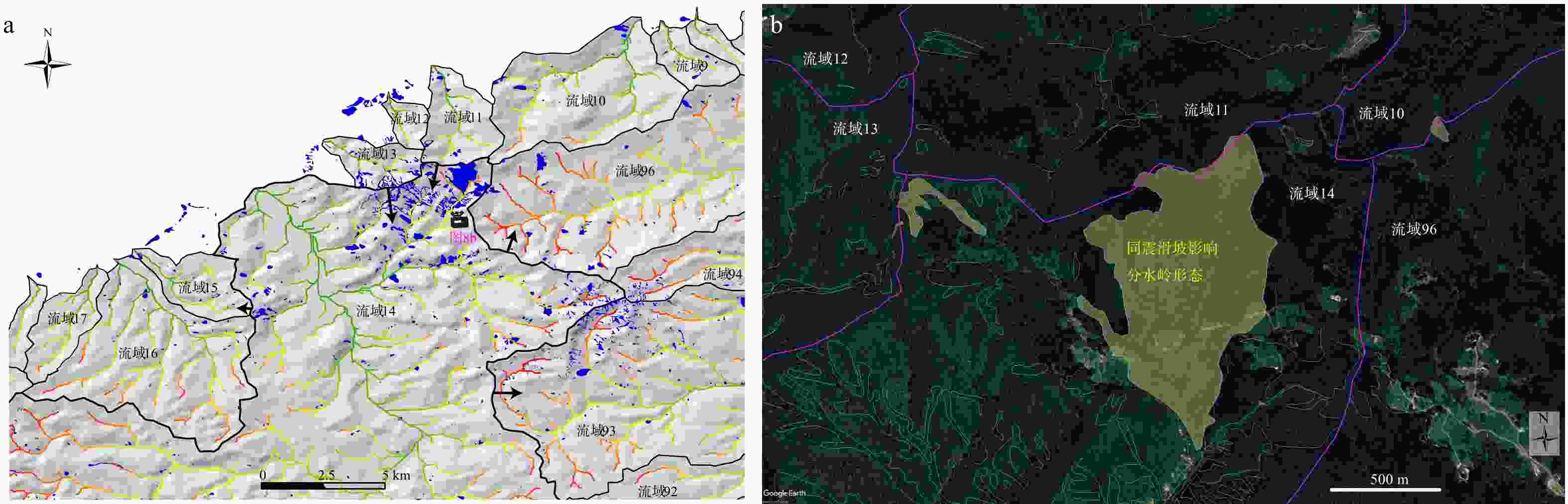
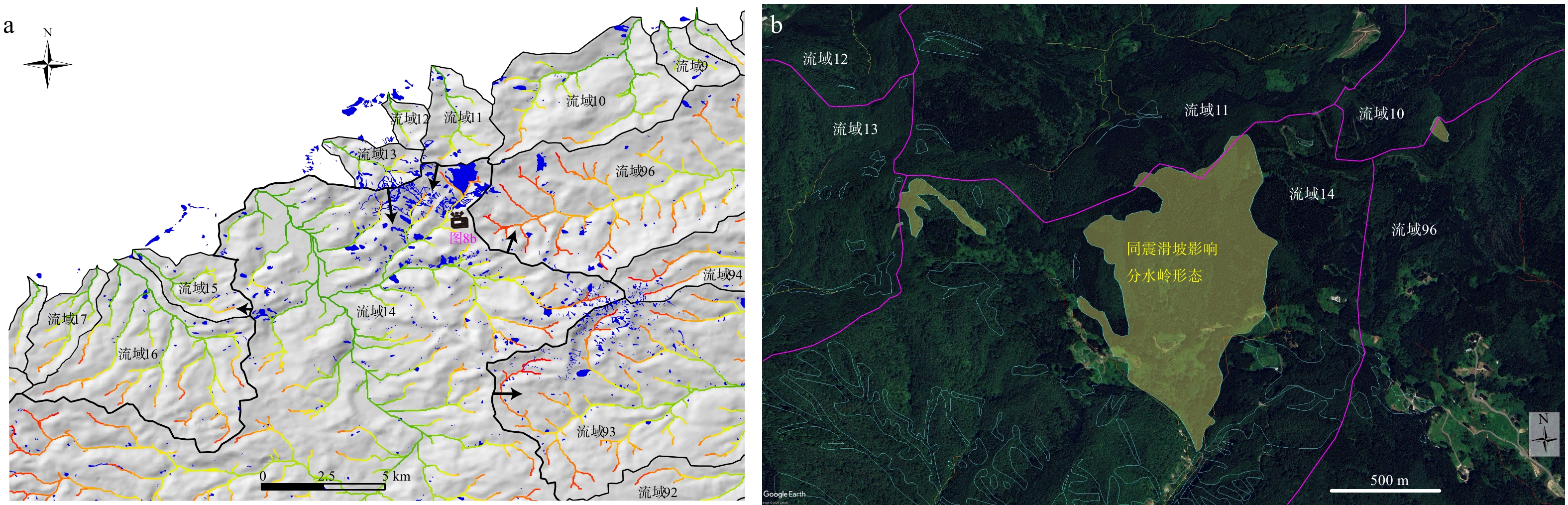
图 8 第14号流域分水岭附近的同震滑坡分布
a—地震滑坡分布情况以及Chi值预测的分水岭迁移方向;b—同震滑坡跨过流域分水岭(底图为谷歌影像)
Figure 8. Distribution of co-seismic landslides near the divide of the drainage No. 14
(a) Distribution of co-seismic landslides and the divide migration direction predicted by χ values; (b) Co-seismic landslides crossing the drainage divide (Base map derived from Google Earth imagery)
-
[1] BAGHA N, ARIAN M, GHORASHI M, et al., 2014. Evaluation of relative tectonic activity in the Tehran basin, central Alborz, northern Iran[J]. Geomorphology, 213: 66-87. doi: 10.1016/j.geomorph.2013.12.041 [2] BISHOP P, 1995. Drainage rearrangement by river capture, beheading and diversion[J]. Progress in Physical Geography, 19(4): 449-473. doi: 10.1177/030913339501900402 [3] CHANG Z Y, WANG J, BAI S B, et al., 2014. Appraisal of active tectonic in Bailongjiang basin based on DEM data[J]. Quaternary Sciences, 34(2): 292-301. (in Chinese with English abstract) [4] CHEN G Q, WU Y Q, XIA M Y, et al., 2024. Focal mechanics and disaster characteristics of the 2024 M 7.6 Noto Peninsula Earthquake, Japan[J]. Frontiers of Structural and Civil Engineering, 18(9): 1378-1387. doi: 10.1007/s11709-024-1111-1 [5] CHENG Y L, HE C Q, RAO G, et al., 2018. Geomorphological and structural characterization of the southern Weihe Graben, central China: implications for fault segmentation[J]. Tectonophysics, 722: 11-24. doi: 10.1016/j.tecto.2017.10.024 [6] DAHLQUIST M P, WEST A J, LI G, 2018. Landslide-driven drainage divide migration[J]. Geology, 46(5): 403-406. doi: 10.1130/G39916.1 [7] DAL PAI M O, SALGADO A A R, DE SORDI M V, et al., 2023. Comparing morphological investigation with χ index and gilbert metrics for analysis of drainage rearrangement and divide migration in inland plateaus[J]. Geomorphology, 423: 108554. doi: 10.1016/j.geomorph.2022.108554 [8] EL HAMDOUNI R, IRIGARAY C, FERNÁNDEZ T, et al, 2008. Assessment of relative active tectonics, southwest border of the Sierra Nevada (southern Spain)[J]. Geomorphology, 96(1-2): 150-173. doi: 10.1016/j.geomorph.2007.08.004 [9] FAN N N, KONG P, ROBL J C, et al., 2021. Timing of river capture in major Yangtze River tributaries: insights from sediment provenance and morphometric indices[J]. Geomorphology, 392: 107915. doi: 10.1016/j.geomorph.2021.107915 [10] FANG D J, SUN W Y, ZHOU Y, et al. , 2024. Characteristics statistical analysis for records of Mw7.5 earthquake occurred at Noto Peninsula in Japan on January 1, 2024[J]. Journal of Vibration and Shock, 43(23): 155-163, 185. (in Chinese with English abstract) [11] FORTE A M, WHIPPLE K X, 2018. Criteria and tools for determining drainage divide stability[J]. Earth and Planetary Science Letters, 493: 102-117. doi: 10.1016/j.jpgl.2018.04.026 [12] FUJII Y, SATAKE K, 2024. Slip distribution of the 2024 Noto Peninsula earthquake (MJMA 7.6) estimated from tsunami waveforms and GNSS data[J]. Earth, Planets and Space, 76(1): 44. doi: 10.1186/s40623-024-01991-z [13] FUKUSHIMA Y, ISHIMURA D, TAKAHASHI N, et al., 2024. Landscape changes caused by the 2024 Noto Peninsula earthquake in Japan[J]. Science Advances, 10(49): eadp9193. doi: 10.1126/sciadv.adp9193 [14] Geospatial Information Authority of Japan, 2024. Information regarding the 2024 Noto Peninsula earthquake[EB/OL]. [2024-05-08]. https://www.gsi.go.jp/BOUSAI/20240101_noto_earthquake.html. (in Japanese) [15] HE C Q, RAO G, YANG R, et al., 2019. Divide migration in response to asymmetric uplift: insights from the Wula Shan horst, North China[J]. Geomorphology, 339: 44-57. doi: 10.1016/j.geomorph.2019.04.024 [16] HE C Q, YANG C J, TUROWSKI J M, et al., 2021. Constraining tectonic uplift and advection from the main drainage divide of a mountain belt[J]. Nature Communications, 12(1): 544. doi: 10.1038/s41467-020-20748-2 [17] HE C Q, BRAUN J, TANG H, et al., 2024. Drainage divide migration and implications for climate and biodiversity[J]. Nature Reviews Earth & Environment, 5(3): 177-192. [18] HOWARD A D, KERBY G, 1983. Channel changes in badlands[J]. Geological Society of America Bulletin, 94(6): 739-752. doi: 10.1130/0016-7606(1983)94<739:CCIB>2.0.CO;2 [19] INOUE T, OKAMURA Y, 2010. Explanatory notes of 1: 200, 000 marine geological map around the northern part of Noto peninsula[R]. Tsukuba: Geological Survey of Japan, AIST. (in Japanese) [20] INOUE T, OZAKI M, OKAMURA Y, 2010. 1: 200, 000 Seamless geological map of the northern part of Noto Peninsula[EB/OL]. https://www.gsj.jp/data/coastal-geology/GSJ_DGM_S1_2010_03_a.pdf. (in Japanese) [21] ISHIKAWA Y, BAI L, 2024. The 2024 Mj 7.6 Noto Peninsula, Japan earthquake caused by the fluid flow in the crust[J]. Earthquake Research Advances, 4(3): 100292. doi: 10.1016/j.eqrea.2024.100292 [22] KIRBY E, WHIPPLE K X, 2012. Expression of active tectonics in erosional landscapes[J]. Journal of Structural Geology, 44: 54-75. doi: 10.1016/j.jsg.2012.07.009 [23] KOBAYASHI H, WATANABE T, KOKETSU K, 2025. Rupture process of the 2024 Noto Peninsula earthquake inferred from strong motion, teleseismic, and geodetic data[J]. Earth, Planets and Space, 77: 104. doi: 10.1186/s40623-025-02238-1 [24] LI Y Y, YANG R, XU C C, 2025. Analysis of morphological variability on the southeastern Tibetan Plateau and its causes: a case study of the Yajiang area[J]. Quaternary Sciences, 45(1): 117-131. (in Chinese with English abstract) [25] LIU C L, BAI Y F, LAY T, et al., 2024. Shallow crustal rupture in a major Mw 7.5 earthquake above a deep crustal seismic swarm along the Noto Peninsula in western Japan[J]. Earth and Planetary Science Letters, 648: 119107. doi: 10.1016/j.jpgl.2024.119107 [26] LÜ Z, SHAO X B, 2004. Research on the diving plate shape characteristic of global diving belt[J]. Seismological Research of Northeast China, 20(3): 17-25. (in Chinese with English abstract) [27] MA Z F, ZENG H Y, LUO H P, et al., 2024. Slow rupture in a fluid-rich fault zone initiated the 2024 Mw 7.5 Noto earthquake[J]. Science, 385(6711): 866-871. doi: 10.1126/science.ado5143 [28] MOGI K, 1963. Some discussions on aftershocks, foreshocks and earthquake swarms: the fracture of a semi-infinite body caused by an inner stress origin and its relation to the earthquake phenomena (third paper)[J]. Bulletin of the Earthquake Research Institute, 41: 615-658. [29] NAKAO K, ICHIMURA T, MUNEKANE H, et al., 2025. Simultaneous Bayesian estimation of multisegment fault geometry and complex slip distribution: application to the 2024 Noto Peninsula earthquake[J]. Geophysical Journal International, 242(2): ggaf231. doi: 10.1093/gji/ggaf231 [30] NISHIMURA T, HIRAMATSU Y, OHTA Y, 2023. Episodic transient deformation revealed by the analysis of multiple GNSS networks in the Noto Peninsula, central Japan[J]. Scientific Reports, 13(1): 8381. doi: 10.1038/s41598-023-35459-z [31] OKUWAKI R, YAGI Y, MURAKAMI A, et al., 2024. A multiplex rupture sequence under complex fault network due to preceding earthquake swarms during the 2024 Mw 7.5 Noto Peninsula, Japan, Earthquake[J]. Geophysical Research Letters, 51(11): e2024GL109224. doi: 10.1029/2024GL109224 [32] PENG Z G, LEI X L, WANG Q Y, et al., 2025. The evolution process between the earthquake swarm beneath the Noto Peninsula, Central Japan and the 2024 M 7.6 Noto Hanto earthquake sequence[J]. Earthquake Research Advances, 5(1): 100332. doi: 10.1016/j.eqrea.2024.100332 [33] PÉREZ-PEÑA J V, AZAÑÓN J M, AZOR A, 2009. CalHypso: an ArcGIS extension to calculate hypsometric curves and their statistical moments. Applications to drainage basin analysis in SE Spain[J]. Computers & Geosciences, 35(6): 1214-1223. [34] RAO G, CHENG Y L, LIN A M, et al., 2017. Relationship between landslides and active normal faulting in the epicentral area of the AD 1556 M~8.5 Huaxian Earthquake, SE Weihe Graben (Central China)[J]. Journal of Earth Science, 28(3): 545-554. doi: 10.1007/s12583-017-0900-z [35] RAO G, ZHONG Y Q, YIN X H, 2025. Geomorphological evidence for superimposed deformation in the southern Sichuan Basin, SW China: implications for seismic hazards[J]. Earth Surface Processes and Landforms, 50(9): e70120. doi: 10.1002/esp.70120 [36] REN Z K, LIN A M, 2010. Co-seismic landslides induced by the 2008 Wenchuan magnitude 8.0 Earthquake, as revealed by ALOS PRISM and AVNIR2 imagery data[J]. International Journal of Remote Sensing, 31(13): 3479-3493. doi: 10.1080/01431161003727770 [37] REN Z K, ZHANG Z Q, DAI F C, et al., 2014. Topographic changes due to the 2008 Mw 7.9 Wenchuan earthquake as revealed by the differential DEM method[J]. Geomorphology, 217: 122-130. doi: 10.1016/j.geomorph.2014.04.020 [38] SHI F, TAN X B, ZHOU C, et al., 2021. Impact of asymmetric uplift on mountain asymmetry: analytical solution, numerical modeling, and natural examples[J]. Geomorphology, 389: 107862. doi: 10.1016/j.geomorph.2021.107862 [39] STRAHLER A N, 1952. Hypsometric (area-altitude) analysis of erosional topography[J]. GSA Bulletin, 63(11): 1117-1142. doi: 10.1130/0016-7606(1952)63[1117:HAAOET]2.0.CO;2 [40] TARUMI K, YOSHIZAWA K, 2025. Frequency-dependent seismic radiation process of the 2024 Noto Peninsula earthquake from teleseismic P-wave back-projection[J]. Earth and Planetary Science Letters, 666: 119509. doi: 10.1016/j.jpgl.2025.119509 [41] TONG F T, DONG Y P, LIU Y, et al., 2024. Migration characteristics of the watershed between Nanpan River and Red River based on morphotectonics[J]. Chinese Journal of Geology, 59(2): 535-548. (in Chinese with English abstract) [42] UMEDA K, YAMAZAKI Y, SUMINO H, 2024. Geochemical signature of deep fluids triggering earthquake swarm in the Noto Peninsula, Central Japan[J]. Geophysical Research Letters, 51(13): e2024GL108581. doi: 10.1029/2024GL108581 [43] WANG F W, LI R, ZHANG S, et al., 2025. Characteristics and controlling factors of landslides triggered by the 2024 Noto Peninsula Earthquake[J]. Nat Hazards, 121(16): 18551-18572. doi: 10.1007/s11069-025-07528-1 [44] WANG Y Z, ZHENG D W, ZHANG H P, 2022. The methods and program implementation for river longitudinal profile analysis: RiverProAnalysis, a set of open-source functions based on the Matlab platform[J]. Science China Earth Sciences, 65(9): 1788-1809. doi: 10.1007/s11430-021-9938-x [45] WHIPPLE K X, TUCKER G E, 1999. Dynamics of the stream-power river incision model: implications for height limits of mountain ranges, landscape response timescales, and research needs[J]. Journal of Geophysical Research: Solid Earth, 104(B8): 17661-17674. doi: 10.1029/1999JB900120 [46] WHIPPLE K X, FORTE A M, DIBIASE R A, et al., 2017. Timescales of landscape response to divide migration and drainage capture: implications for the role of divide mobility in landscape evolution[J]. Journal of Geophysical Research: Earth Surface, 122(1): 248-273. doi: 10.1002/2016JF003973 [47] WILLETT S D, MCCOY S W, PERRON J T, et al., 2014. Dynamic reorganization of river basins[J]. Science, 343(6175): 1248765. doi: 10.1126/science.1248765 [48] WOBUS C, WHIPPLE K X, KIRBY E, et al. , 2006. Tectonics from topography: procedures, promise, and pitfalls[M]//WILLETT S D, HOVIUS N, BRANDON M T, et al. Tectonics, climate, and landscape evolution. Boulder: Geological Society of America: 55-74. [49] WU Y P, YANG R, HE C Q, et al., 2022. Caution on determining divide migration from cross-divide contrast in χ[J]. Geological Journal, 57(10): 4090-4098. doi: 10.1002/gj.4530 [50] XU Q R, DONG Y P, XIE Z P, et al., 2024. Tectonic and geomorphological characteristics of Laoyingshan in the eastern Sichuan-Yunnan block: insights into the uplift and rotation of the blocks[J]. Journal of Geomechanics, 30(4): 535-546. (in Chinese with English abstract) [51] YANG R, SUHAIL H A, GOURBET L, et al., 2020. Early Pleistocene drainage pattern changes in Eastern Tibet: constraints from provenance analysis, thermochronometry, and numerical modeling[J]. Earth and Planetary Science Letters, 531: 115955. doi: 10.1016/j.jpgl.2019.115955 [52] YANG S Y, SANG C F, HU Y, et al., 2024. Coseismic and early postseismic deformation of the 2024 Mw7.45 Noto Peninsula earthquake[J]. Geophysical Research Letters, 51(11): e2024GL108843. doi: 10.1029/2024GL108843 [53] YOSHIDA K, TAKAGI R, FUKUSHIMA Y, et al., 2024. Role of a hidden fault in the early process of the 2024 Mw7.5 Noto Peninsula earthquake[J]. Geophysical Research Letters, 51(16): e2024GL110993. doi: 10.1029/2024GL110993 [54] YUHI M, UMEDA S, ARITA M, et al., 2024. Dataset of post-event survey of the 2024 Noto Peninsula Earthquake Tsunami in Japan[J]. Scientific Data, 11(1): 786. doi: 10.1038/s41597-024-03619-z [55] ZHANG K Z, WAN Y G, 2024. Inversion of rupture process of the Japan MW7.6 earthquake on January 1, 2024[J]. Acta Seismologica Sinica, 46: 1-18. (in Chinese with English abstract) [56] ZHANG L J, YUAN D Y, LI H Q, et al., 2025. Tectonic geomorphological evidence of late Quaternary segmented activity along the northern margin fault of Lajishan[J]. Journal of Geomechanics, 31(3): 411-426. (in Chinese with English abstract) [57] ZHONG Y Q, RAO G, YIN X H, et al., 2026. Drainage response to superimposed deformation of the Weiyuan anticline in the southwestern Sichuan Basin, China[J]. Journal of the Geological Society, 183(1): jgs2025091. doi: 10.1144/jgs2025-091 [58] 常直杨, 王建, 白世彪, 等, 2014. 基于DEM的白龙江流域构造活动定量分析[J]. 第四纪研究, 34(2): 292-301. [59] 方登甲, 孙纬宇, 周宇, 等, 2024. 2024年1月1日日本Mw7.5级能登半岛地震记录特征统计分析[J]. 振动与冲击, 43(23): 155-163, 185. [60] 李阳阳, 杨蓉, 徐陈超, 2025. 青藏高原东南缘地貌差异性成因分析: 以雅江地区为例[J]. 第四纪研究, 45(1): 117-131. [61] 吕政, 邵喜彬, 2004. 全球俯冲带形态特征研究[J]. 东北地震研究, 20(3): 17-25. [62] 童方彤, 董有浦, 刘益, 等, 2024. 基于构造地貌学的南盘江与红河分水岭特征分析[J]. 地质科学, 59(2): 535-548. [63] 王一舟, 郑德文, 张会平, 2022. 河流高程剖面分析的方法与程序实现: 基于Matlab平台编写的开源函数集RiverProAnalysis[J]. 中国科学: 地球科学, 52(10): 2039-2060. [64] 徐琴如, 董有浦, 谢志鹏, 等, 2024. 川滇地块东部老鹰山的构造地貌特征及其揭示的地块隆升和旋转运动[J]. 地质力学学报, 30(4): 535-546. [65] 张凯智, 万永革, 2024. 2024年1月1日日本MW7.6地震破裂过程反演研究[J]. 地震学报, 46: 1-18. [66] 张梨君, 袁道阳, 李红强, 等, 2025. 拉脊山北缘断裂第四纪晚期分段活动的构造地貌证据[J]. 地质力学学报, 31(3): 411-426. -
 2025129资源附件.docx

-

 下载:
下载:


计量
- 文章访问数: 2100
- HTML全文浏览量: 316
- PDF下载量: 39
- 被引次数: 0
