


A 4400-year-old extreme paleo-storm surge recorded in the Dongzhai Port Chenier, Hainan Island, China
-
摘要: 识别古风暴潮记录与极端风暴增水事件,建立长时间尺度台风序列对于预测未来风暴灾害具有重要的科学和实践意义。已有海南岛风暴潮沉积研究多集中在海南岛东部,而对遭受风暴潮灾害最严重的琼州海峡沿岸海湾和河口湾极端风暴灾害关注较少。文章以海南岛铺前湾南部的东寨港乌树村3.2 m厚的贝壳堤为研究对象,通过沉积构造、贝壳来源、贝壳加速器质谱(Accelerator Mass Spectrometry,AMS) 14C测年、地球化学指标及微体古生物分析,认为贝壳堤记录了4400年前的超强风暴潮与极端增水事件。乌树村贝壳堤沉积于全新世高海平面古海岸线向陆一侧的更新世晚期滨海平原上,9个贝壳14C年龄介于4402~6647 a B.P.之间,年龄倒置且新老共存,贝壳分选良好并具有丘状层理、平行层理、波状层理、冲刷面及软沉积变形构造等。贝壳堤与东寨港新滨海平原钻孔岩芯中化石种属、14C年龄对比分析表明,贝壳堤化石来源于近源的铺前河口湾沉积层。贝壳堤化石年龄、侵蚀冲刷面、软沉积变形构造及全新世海平面变化综合分析表明,乌树村贝壳堤由4400年前多次风暴加积而成,由最高风暴沉积尖灭点高程确定风暴增水至少5.5 m,其增水高度接近1980年穿越琼州海峡的8007号台风在雷州湾的特大风暴潮增水高度(5.9 m)。Abstract:
Objective Establishing a long-term typhoon sequence by identifying ancient storm surge records and extreme storm surge elevation events holds significant scientific and practical value for predicting future storm disasters. Previous research on storm surge deposits has predominantly focused on the eastern part of Hainan Island, while relatively limited attention has been given to the extreme storm events in the coastal bays and estuaries along the Qiongzhou Strait—the areas most severely affected by storm surges. Methods This study investigates a 3.2-m-thick shell ridge in Wushu Village, Dongzhai Port, located in the southern part of Puqian Bay on Hainan Island. Analyses of sedimentary structures, shell origins, AMS 14C dating of shells, geochemical indicators, and microfossile assemblages indicate that the shell ridge records a super-strong storm surge and an extreme surge elevation event that occurred 4,400 years ago. The ridge was deposited on a Late Pleistocene coastal plain landward of the Holocene high-sea-level paleo-coastline. Results The 14C ages of nine shells range from 4,402 to 6,647 a B.P., showing age inversions and the coexistence of older and younger shells. The shells are well-sorted and exhibit hummocky bedding, parallel bedding, wavy bedding, scour surfaces, and soft-sediment deformation structures. Conclusions Comparison of fossil species and shell 14C ages between the shell ridge and drill cores from the new coastal plain of Dongzhai Port indicates that the fossils in the shell ridge originated from the nearby sedimentary layers of the Puqian Bay estuary. Integrated analysis of the fossil ages, erosional scour surfaces, soft-sediment deformation structures, and Holocene sea-level changes suggests that the shell ridge in Wushu Village was formed through multiple storm-induced aggradation events occurring 4,400 years ago. Given the elevation of the highest storm deposit pinch-out point, the storm surge height reached at least 5.5 m. This surge height is close to the extraordinary storm surge height (5.9 m) recorded in Leizhou Bay during Typhoon 8007, which crossed the Qiongzhou Strait in 1980. [Significance] This study provides crucial scientific evidence for the prevention and mitigation of extreme storm surge disasters in Hainan, offering valuable insights for regional disaster risk reduction and coastal management. -
Key words:
- chenier /
- superstorm surge event /
- sedimentary characteristics /
- AMS14C dating /
- Dongzhai; PortHainan
-
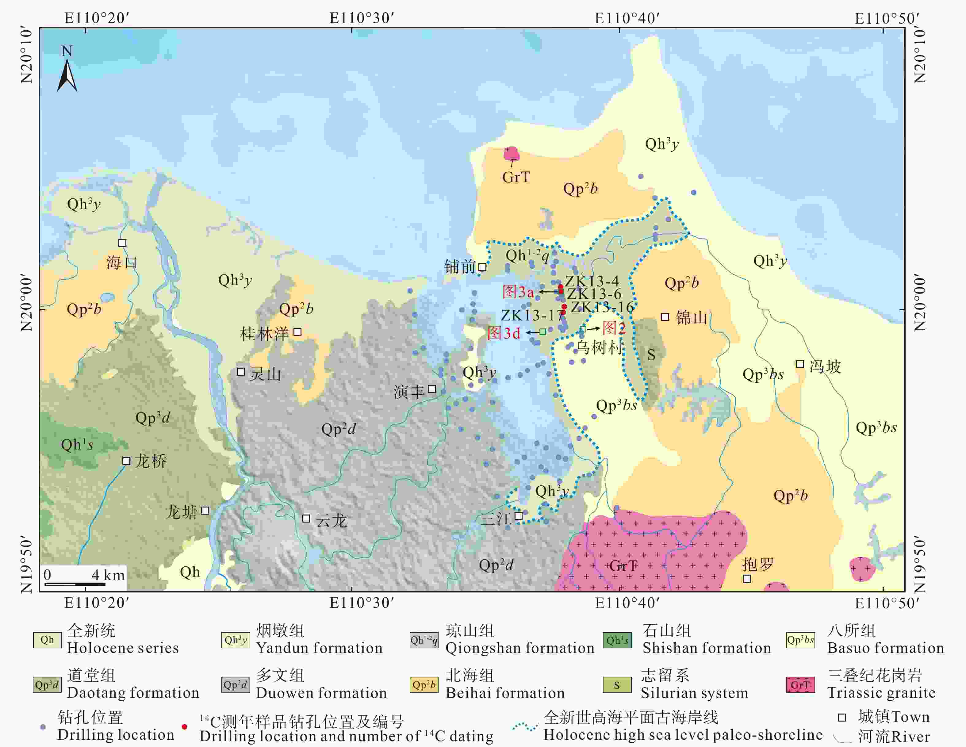
图 1 东寨港古海岸线与风暴潮贝壳堤剖面位置
Figure 1. Map showing the location of the paleo-shoreline and the storm surge chenier profile in Dongzhai Port, Hainan
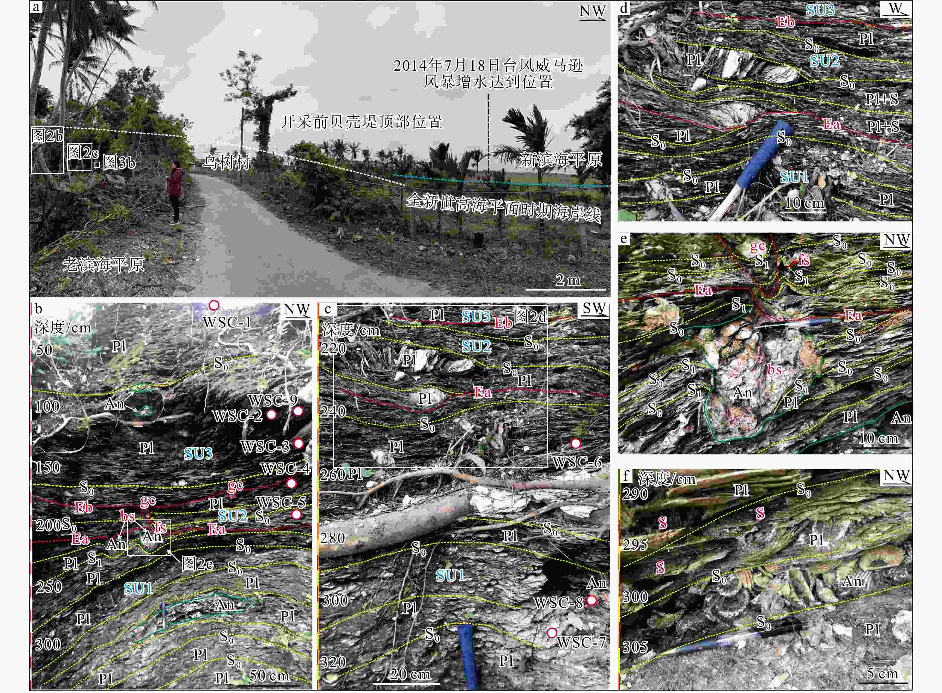
图 2 乌树村贝壳堤14C测年样品位置与沉积构造特征
An—粗饰蚶;Pl—海月;S—粉细砂;S0—层理;S1—变形层理;Ea—早期冲刷面;Eb—晚期冲刷面;bs—球状构造;gc—渠模构造;fs—火焰状构造;红圈—14C测年取样位置;WSC-1—WSC-9—14C测年样品编号a—贝壳堤所在地貌部位;b—贝壳堤沉积构造与SU2单元和SU3单元14C测年样品位置;c—贝壳堤沉积构造与SU1单元14C测年样品位置;d—冲刷面及沉积构造;e—冲刷面与伴生的变形构造;f—海月与粗饰蚶产状与保存状况
Figure 2. Locations of 14C dating samples and sedimentary structures of the shell ridge in Wushu Village
(a) Geomorphic position of the shell ridge; (b) Sedimentary structures and 14C sampling locations for units SU2 and SU3; (c) Sedimentary structures and 14C dating sampling locations for unit SU1; (d) Scour surfaces and sedimentary structures; (e) Scour surfaces and associated deformation structures; (f) Occurrence and preservation of Anadara granosa (Linne) and Placuna Placenta (Linne) An—Anadara granosa (Linne); Pl—Placuna Placenta (Linne); S—silt and fine sand; S0—bedding; S1—deformed bedding; Ea—early scour surface; Eb—late scour surface; bs—ball structure; gc—gutter cast; fs—flame structure; Red circles—sampling locations for 14C dating; WSC-1–WSC-9—sample numbers for 14C dating
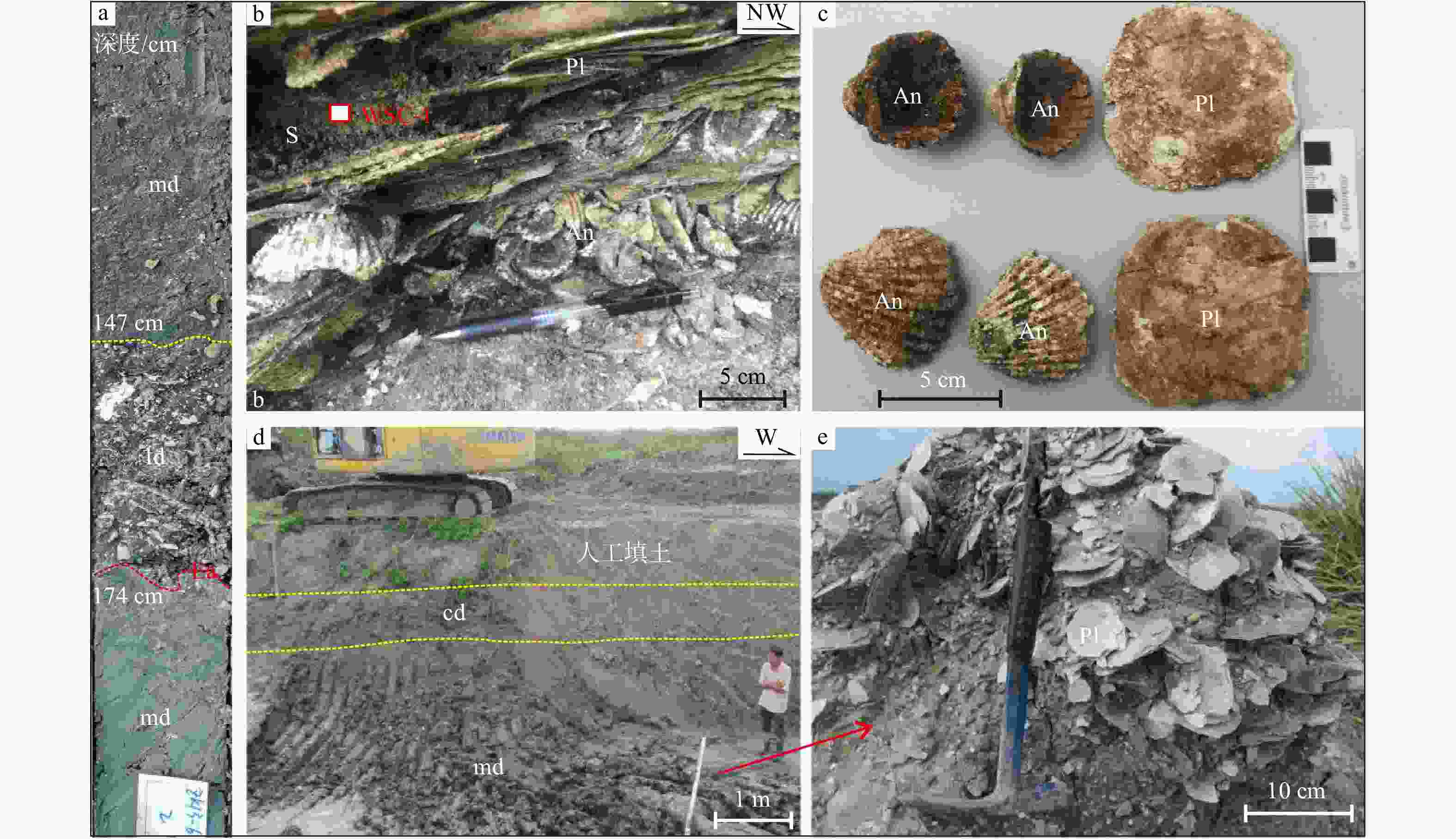
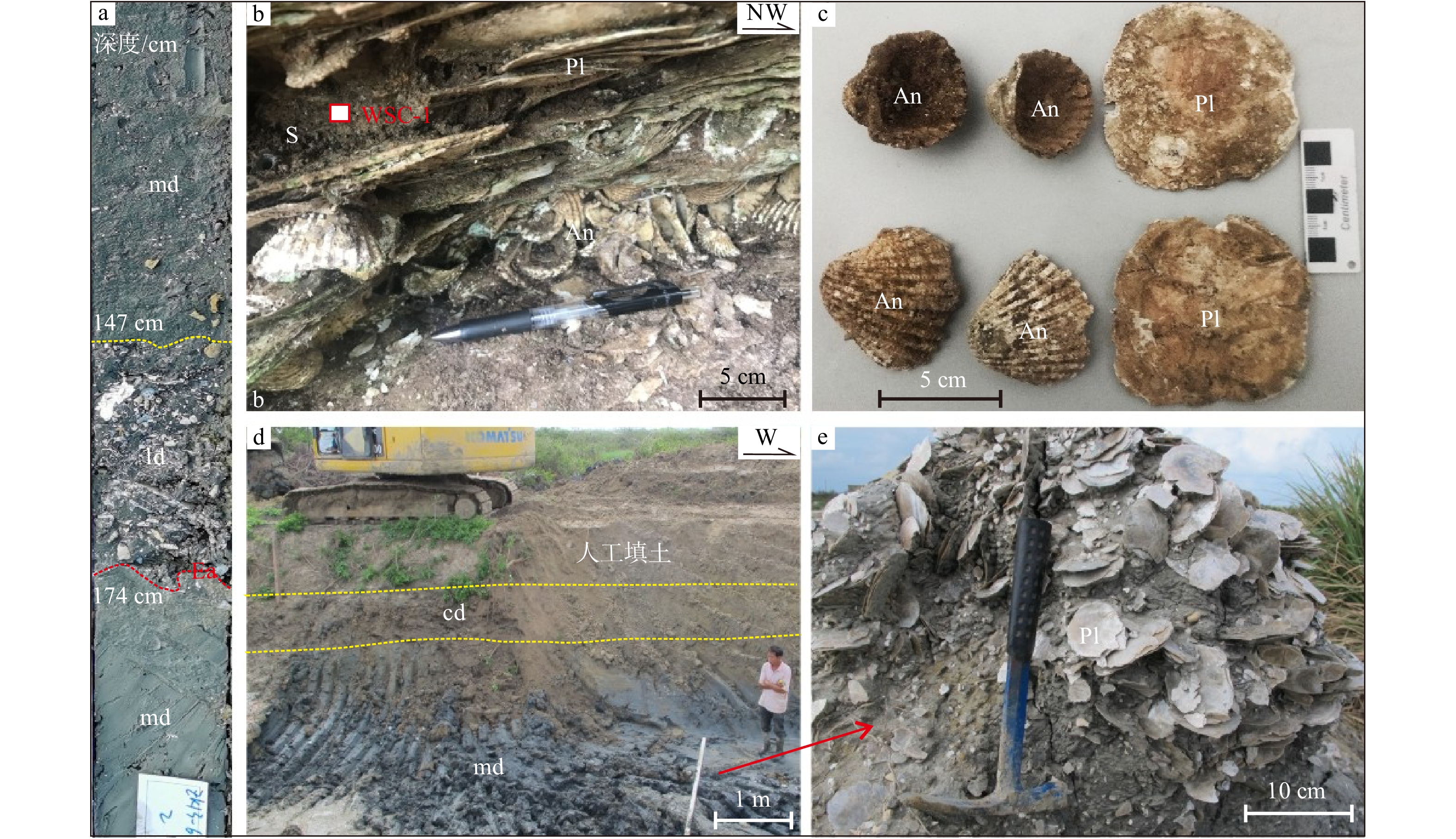
图 3 乌树村贝壳堤和海滩岩采样位置及化石特征
An—粗饰蚶;Pl—海月;md—海相沉积;cd—陆相沉积;ld—滞留沉积;Ea—早期冲刷面a—ZK13-6钻孔岩芯中的滞留沉积;b—乌树村贝壳堤地球化学取样点;c—乌树村贝壳堤中保存完整的粗饰蚶与海月化石;d—东寨港新滨海平原含丰富海月化石的海相沉积与上覆陆相沉积;e—淤泥质粉砂沉积层中保存完好的海月化石
Figure 3. Sampling locations and fossil characteristics of the shell ridge and beachrock in Wushu Village
(a) Lag deposit in drill core ZK13-6; (b) Geochemical sampling points of the shell ridge in Wushu Village; (c) Intact Anadara granosa (Linne) and Placuna Placenta (Linne) fossils preserved in the shell ridge of Wushu Village; (d) Marine deposit rich in Placuna Placenta (Linne) fossils and overlying continental deposit in the new coastal plain of Dongzhai Port; (e) Well-preserved Placuna Placenta (Linne) fossils in the silty silt deposit layer An—Anadara granosa (Linne); Pl—Placuna Placenta (Linne); md—marine deposit; cd—continental deposit; ld—lag deposit in drill core ZK13-6; Ea—early scour surface
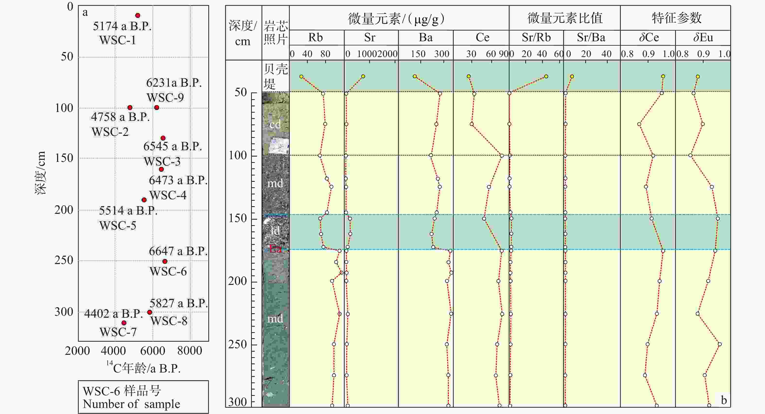
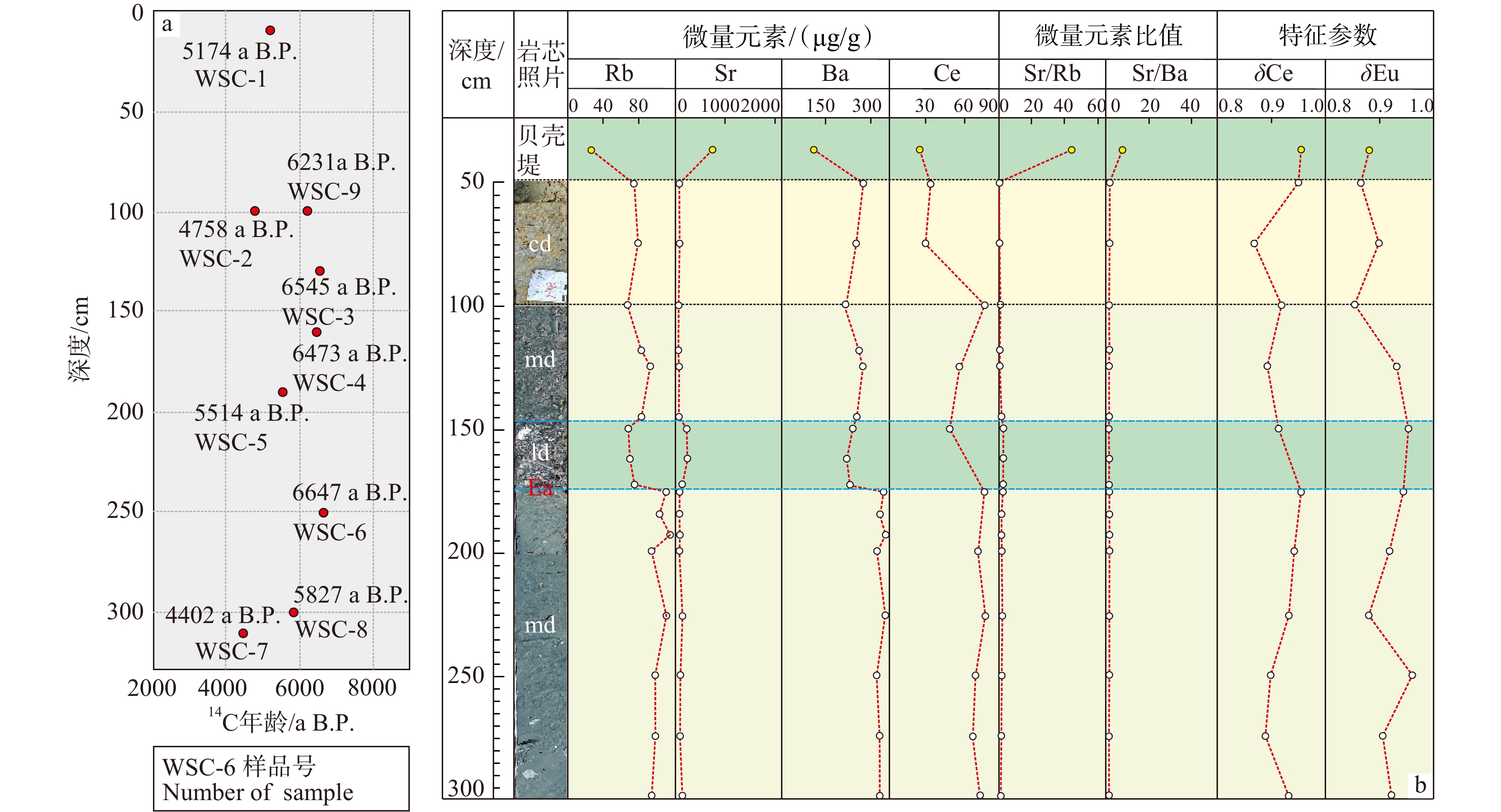
图 4 乌树村贝壳堤AMS 14C年龄随深度变化图与地球化学指标图
An—粗饰蚶;Pl—海月;md—海相沉积;cd—陆相沉积;ld—滞留沉积;Ea—早期冲刷面a—乌树村贝壳堤9个贝壳AMS 14C年龄随深度变化图;b—钻孔ZK13-6地层与贝壳堤地球化学指标对比图
Figure 4. Variation of AMS 14C ages with depth in the shell ridge of Wushu Village, along with geochemical indicators
(a) Graph showing the variation of nine AMS 14C ages of shells with depth in the shell ridge of Wushu Village; (b) Graph comparing geochemical indicators among the strata of drill core ZK13-6 and the shell ridge An—Anadara granosa (Linne);Pl—Placuna Placenta (Linne); md—marine deposit; cd—continental deposit; ld—lag deposit in drill core ZK13-6; Ea—Early scour surface
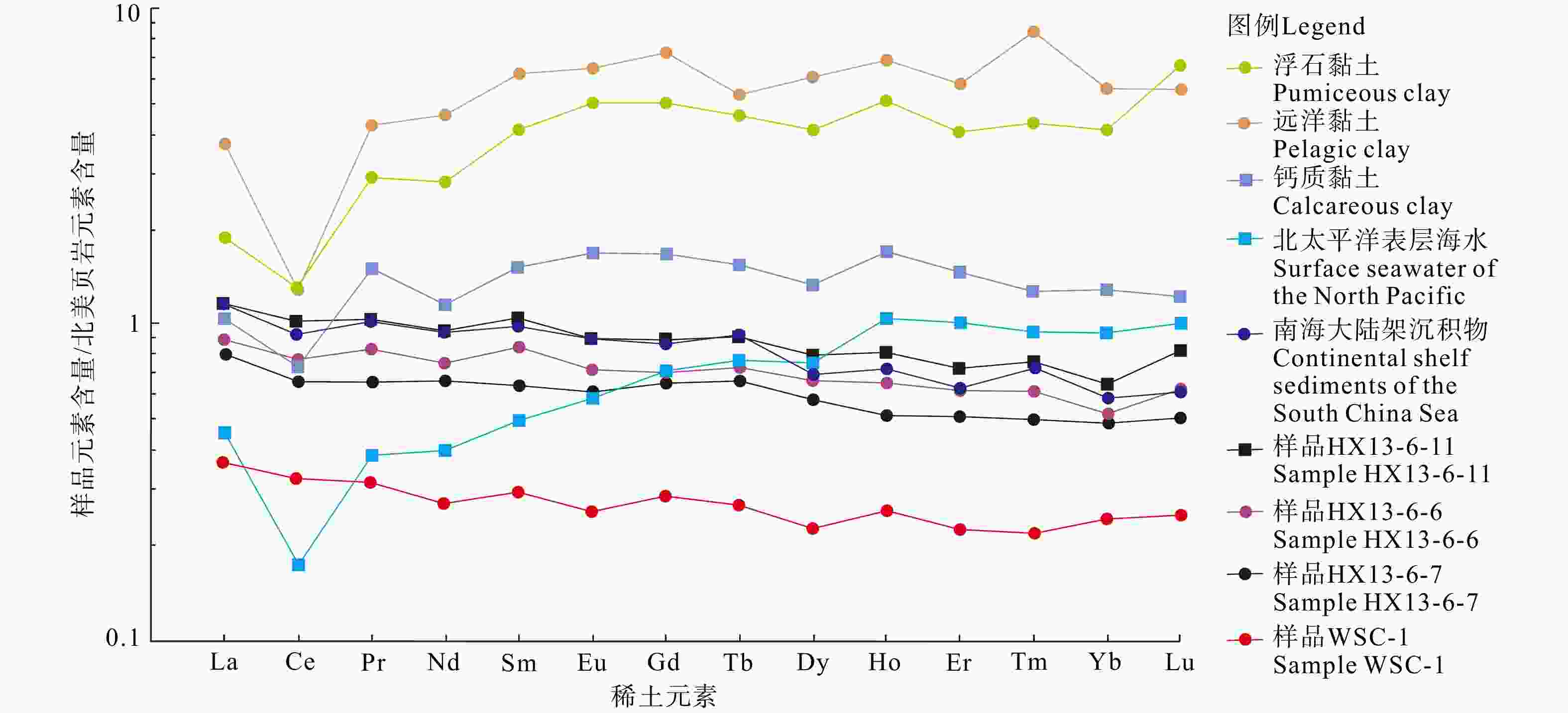
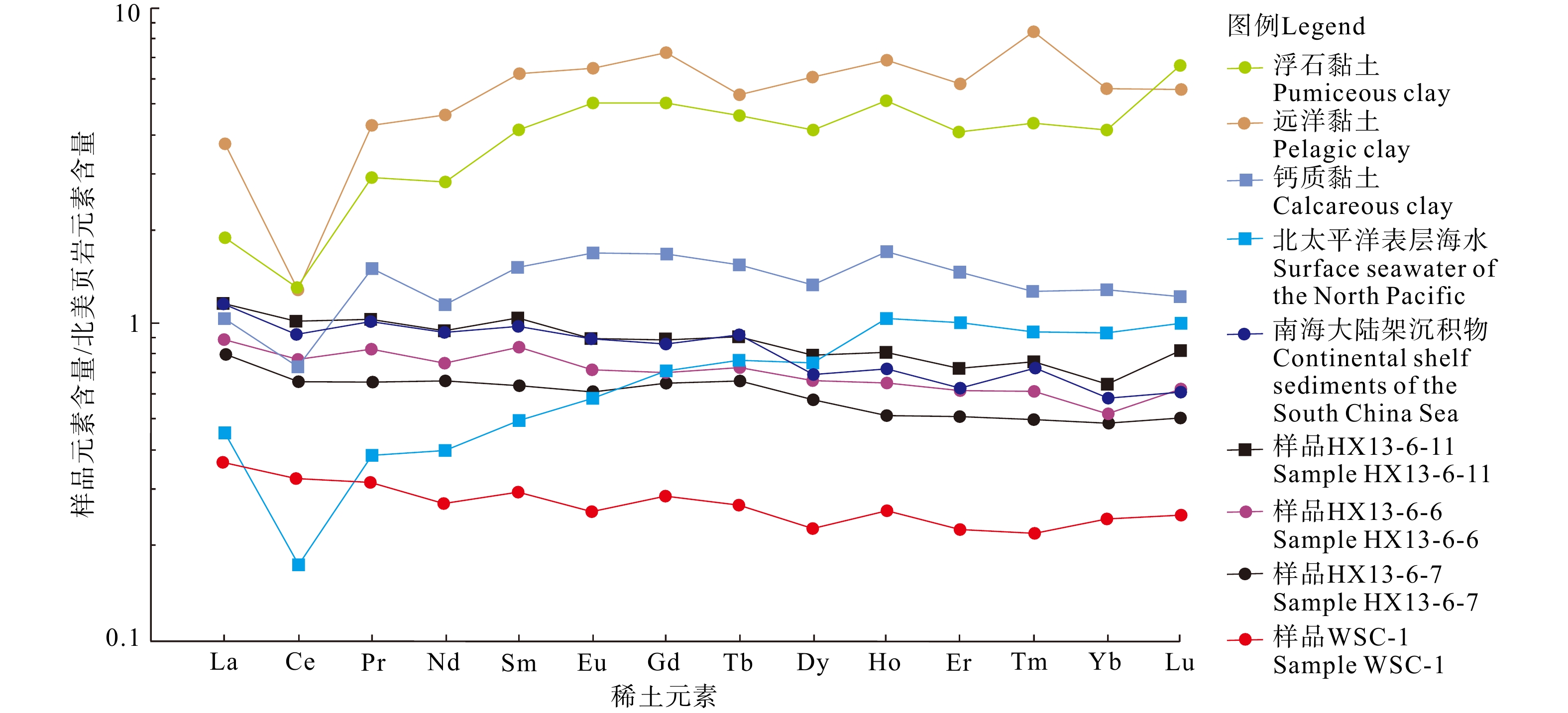
图 5 乌树村贝壳堤碎屑与不同环境沉积物稀土元素配分模式图
Figure 5. Rare earth element distribution patterns of sediments from the shell ridge in Wushu Village and from other environmental settings for comparion
表 1 海南东寨港乌树村贝壳堤和钻孔岩芯贝壳AMS 14C定年结果
Table 1. AMS 14C dating results for shells from the shell ridge and borehole cores of Wushu Village, Dongzhai Port, Hainan
位置 样品号 沉积单元 样品深度/cm 测年物质 测量年龄 /a B.P. 校正年龄/a B.P.
(概率95.4%)中值校正年龄 /a B.P. 乌树村贝壳堤 WSC-1 平行层理段
(SU3单元)10 海月 4885±25 4956~5358 5174 WSC-2 100 海月 4559±25 4564~4945 4758 WSC-9 100 粗饰蚶 5832±53 5998~6395 6213 WSC-3 130 海月 6146±76 6307~6775 6545 WSC-4 波状层理段
(SU2单元)160 海月 6080±58 6276~6674 6473 WSC-5 190 海月 5185±26 5325~5667 5514 WSC-6 丘状层理段
(SU1单元)250 海月 6237±47 6441~6851 6647 WSC-8 300 粗饰蚶 5481±81 5588~6080 5827 WSC-7 310 海月 4276±24 4206~4601 4402 新滨海平原钻孔岩芯 ZK13-4-1 贝壳缩聚层 135 螺 5195±40 5329~5696 5523 ZK13-6-2 154 螺 5365±40 5544~5895 5707 ZK13-16-1 180 海月 6060±40 6279~6635 6451 ZK13-17-2 220 海月 5590±40 5761~6160 5957 ZK13-4-13 原位沉积 430 海月 7060±45 7346~7662 7508 ZK13-6-6 430 海月 7005±50 7287~7615 7460 ZK13-16-2 520 海月 6230±45 6437~6841 6639 ZK13-17-3 390 海月 6560±40 6827~7219 7021  下载: 导出CSV
表 2 乌树村贝壳堤和不同沉积环境沉积物元素含量(μg/g)与参数
Table 2. Element contents (μg/g) and parameters of sediments from the shell ridge in Wushu Village and from other sedimentary environments for comparison
样品号 深度/cm Rb Sr Ba Sr/Ba Sr/Rb LREE/HREE ΣREE δCe δEu WSC-1 310.00 17.30 768.00 109.00 7.05 44.39 7.29 54.27 0.95 0.88 HX13-6-3 50.00 74.70 53.30 271.00 0.19 0.71 8.90 80.02 0.95 0.87 HX13-6-4 75.00 77.20 52.10 246.00 0.21 0.67 8.43 72.21 0.87 0.90 HX13-6-5 100.00 66.10 48.10 212.00 0.23 0.73 8.92 183.18 0.92 0.86 ZK13-6-27 118.00 81.40 66.50 259.00 0.26 0.82 / / / / HX13-6-6 125.00 90.70 73.90 273.00 0.27 0.81 9.31 135.10 0.89 0.93 ZK13-6-28 145.00 82.00 71.50 253.00 0.28 0.87 / / / / HX13-6-7 150.00 67.10 147.00 236.00 0.62 2.19 9.11 117.70 0.92 0.95 ZK13-6-25 162.00 69.30 235.00 215.00 1.09 3.39 / / / / ZK13-6-26 173.00 74.70 219.00 226.00 0.97 2.93 / / / / HX13-6-8 175.00 110.00 119.00 333.00 0.36 1.08 9.26 180.89 0.96 0.94 ZK13-6-30 185.00 103.00 92.40 324.00 0.29 0.90 / / / / ZK13-6-29 193.00 116.00 101.00 348.00 0.29 0.87 / / / / HX13-6-9 200.00 92.40 111.00 316.00 0.35 1.17 9.38 151.69 0.94 0.92 HX13-6-10 225.00 110.00 143.00 345.00 0.41 1.30 9.49 166.44 0.93 0.88 HX13-6-11 250.00 97.70 104.00 314.00 0.33 1.06 9.58 157.25 0.90 0.96 HX13-6-12 275.00 98.70 101.00 322.00 0.31 1.02 9.46 148.58 0.89 0.91 HX13-6-13 300.00 93.40 113.00 326.00 0.35 1.21 9.79 157.76 0.93 0.93 ZK13-6岩芯平均值 88.40 108.80 283.00 0.40 1.28 9.24 140.98 0.92 0.91 中国陆域(赵一阳, 鄢明才,1993) 90.00 200.00 510.00 0.39 2.22 / / / / 南海沿岸泥(赵一阳等,2002) 122.00 128.00 342.00 0.37 1.05 / / / / 南海西北部大陆架(王兆生等,2020) / / / / / 10.30 164.77 0.86 0.97 南海黄岩岛北部(王赛宇,2022) 139.00 171.00 593.00 0.29 1.23 9.08 180.00 1.00 0.67 西太平洋浮石黏土(黄牧,2013) / 309.00 2967.00 0.10 / 3.62 564.34 0.32 1.14 西太平洋钙质软泥(黄牧,2013) / 1082.00 605.00 0.56 / 3.85 37.58 0.42 1.26 西太平洋远洋黏土(黄牧,2013) / 154.00 1152.00 0.13 / 5.91 215.78 0.74 1.17
下载: 导出CSV
-
[1] BI F Z, HAN M K, ZHAO S S, et al., 1988. Depositional layers of Placuna placenta and characteristics of coastal uplift-subsidence in Luodou Farm, Dongzhai Port, Hainan Island[J]. Marine Science Bulletin, 7(3): 35-40. (in Chinese) [2] BOLTON A, GOODKIN N F, DRUFFEL E R M, et al., 2016. Upwelling of pacific intermediate water in the South China Sea revealed by coral radiocarbon record[J]. Radiocarbon, 58(1): 37-53. doi: 10.1017/RDC.2015.4 [3] BONDEVIK S, SVENDSEN J I, JOHNSEN G, et al., 1997. The Storegga tsunami along the Norwegian coast, its age and run up[J]. Boreas, 26(1): 29-53. doi: 10.1111/j.1502-3885.1997.tb00649.x [4] BOSE P K, CHANDA S K, 1986. Storm deposits and hummocky cross-stratification: a geological viewpoint[J]. Q. J. Geol. , Min. Metall. Soc. Indian, 58(1): 53-68. [5] CHAGUE-GOFF C, GOFF J R, 1999. Geochemical and sedimentological signature of catastrophic saltwater inundations (tsunami), New Zealand[J]. Quaternary Australasia, 17(1): 38-48. [6] CHAN J C L, 2005. Interannual and interdecadal variations of tropical cyclone activity over the western North Pacific[J]. Meteorology and Atmospheric Physics, 89(1-4): 143-152. doi: 10.1007/s00703-005-0126-y [7] CHEN Y, CHEN Q F, ZHANG W, 2007. Tsunami disaster in China[J]. Journal of Natural Disasters, 16(2): 1-6. (in Chinese with English abstract) [8] COCHRAN U A, BERRYMAN K R, MILDENHALL D C, et al., 2005. Towards a record of Holocene tsunami and storms for northern Hawke’s Bay, New Zealand[J]. New Zealand Journal of Geology and Geophysics, 48(3): 507-515. doi: 10.1080/00288306.2005.9515129 [9] DANG P X, MITSUGUCHI T, KITAGAWA H, et al., 2004. Marine reservoir correction in the south of Vietnam estimated from an annually-banded coral[J]. Radiocarbon, 46(2): 657-660. doi: 10.1017/S0033822200035712 [10] DAWSON A G, LONG D, SMITH D E, 1988. The Storegga Slides: evidence from Eastern Scotland for a possible tsunami[J]. Marine Geology, 82(3-4): 271-276. doi: 10.1016/0025-3227(88)90146-6 [11] DAWSON A G, STEWART I, 2007. Tsunami deposits in the geological record[J]. Sedimentary Geology, 200(3-4): 166-183. doi: 10.1016/j.sedgeo.2007.01.002 [12] DAWSON S, SMITH D E, RUFFMAN A, et al., 1996. The diatom biostratigraphy of tsunami sediments: examples from recent and middle Holocene events[J]. Physics and Chemistry of the Earth, 21(1-2): 87-92. doi: 10.1016/S0079-1946(97)00015-3 [13] DING Y Y, ZHAO X T, HU D G, et al., 2018. Late Cenozoic fault activity in northeastern Hainan Island and its controlling effect on tectonic subsidence in Dongzhai Port[J]. Acta Geoscientica Sinica, 39(2): 155-166. (in Chinese with English abstract) [14] DOTT JR R H, BOURGEOIS J, 1982. Hummocky stratification: significance of its variable bedding sequences[J]. GSA Bulletin, 93(8): 663-680. doi: 10.1130/0016-7606(1982)93<663:hssoiv>2.0.co;2 [15] FLEET A J, 1984. Aqueous and sedimentary geochemistry of the rare earth elements[M]. Henderson P. Rare Earth Element Geochemistry. Amsterdam: Elsevier Science Publishers B. V. , 343-373. [16] GOFF J, MCFADGEN B G, CHAGUÉ-GOFF C, 2004. Sedimentary differences between the 2002 Easter storm and the 15th-century Okoropunga tsunami, southeastern North Island, New Zealand[J]. Marine Geology, 204(1-2): 235-250 [17] GOFF J, CHAGUÉ-GOFF C, NICHOL S, et al. , 2012. Progress in palaeotsunami research[J]. Sedimentary Geology, 243-244: 70-88. [18] HE H J, 1988. Storm surges along the coast of Guangdong and Hainan[J]. Tropic Oceanology(2): 37-44. (in Chinese with English abstract) [19] HEATON T J, KÖHLER P, BUTZIN M, et al., 2020. Marine20-The marine radiocarbon age calibration curve (0-55, 000 cal BP)[J]. Radiocarbon, 62(4): 779-820. doi: 10.1017/RDC.2020.68 [20] HUANG M, 2013. Preliminary study on the geochemical characteristics of rare earth elements and resource potential of deep-sea sediments in the Pacific Ocean[D]. Qingdao: The First Institute of Oceanography, State Oceanic Administration: 19-29. (in Chinese) [21] ISHIZAWA T, GOTO K, YOKOYAMA Y, et al., 2020. Dating tsunami deposits: present knowledge and challenges[J]. Earth-Science Reviews, 200: 102971. doi: 10.1016/j.earscirev.2019.102971 [22] KORTEKAAS S, DAWSON A G, 2007. Distinguishing tsunami and storm deposits: an example from Martinhal, SW Portugal[J]. Sedimentary Geology, 200(3-4): 208-221. doi: 10.1016/j.sedgeo.2007.01.004 [23] LI D H. 2022. Marine Transgression and Its Chronology Since the Last Glacial Maximum in the Dongzhaigang Area Recorded by Boreholes[D]. Nanjing Normal University. 32-56. (in Chinese with English abstract) [24] LI J S, YANG J G, 1991. Shell ridges in the Luodou area of Hainan Island[J]. Marine Sciences(6): 73. (in Chinese) [25] LI L L, QIU Q, LI Z G, et al., 2022. Tsunami hazard assessment in the South China Sea: a review of recent progress and research gaps[J]. Science China Earth Sciences, 65(5): 783-809. doi: 10.1007/s11430-021-9893-8 [26] LIAO X X, LI S, WANG G Y, et al., 2009. Grain-size features of Aeolian sands on eastern coast of Hainan Island and the reflected sedimentary environment since 38 ka BP[J]. Journal of Desert Research, 29(6): 1086-1092. (in Chinese with English abstract) [27] LONG D, SMITH D E, DAWSON A G, 1989. A Holocene tsunami deposit in eastern Scotland[J]. Journal of Quaternary Science, 4(1): 61-66. doi: 10.1002/jqs.3390040107 [28] LV J K, ZHAI S K, YU Z H, et al., 2021. Application and influence factors of redox-sensitive elements in a sedimentary environment[J]. Marine Sciences, 45(12): 108-124. (in Chinese with English abstract) [29] MENG X W, CHEN Z H, WANG X Q, et al., 2001. Rare earth elements-rich phase and enriching mechanism in sediments from CC area, the Pacific Ocean[J]. Acta Oceanologica Sinica, 20(2): 209-214. [30] MORTON R A, GELFENBAUM G, JAFFE B E, 2007. Physical criteria for distinguishing sandy tsunami and storm deposits using modern examples[J]. Sedimentary Geology, 200(3-4): 184-207. doi: 10.1016/j.sedgeo.2007.01.003 [31] NANAYAMA F, SHIGENO K, SATAKE K, et al., 2000. Sedimentary differences between the 1993 Hokkaido-nansei-oki tsunami and the 1959 Miyakojima typhoon at Taisei, southwestern Hokkaido, northern Japan[J]. Sedimentary Geology, 135(1-4): 255-264. doi: 10.1016/S0037-0738(00)00076-2 [32] NELSON A R, SHENNAN I, LONG A J, 1996. Identifying coseismic subsidence in tidal-wetland stratigraphic sequences at the Cascadia subduction zone of western North America[J]. Journal of Geophysical Research: Solid Earth, 101(B3): 6115-6135. doi: 10.1029/95JB01051 [33] SHI H Y, LI W H, LYU Y B, et al., 2015. Comparative analysis of two severe storm surge of Hainan Province in 2014[J]. Marine Forecasts, 32(4): 75-82. (in Chinese with English abstract) [34] SHINOZAKI T, 2021. Geochemical approaches in tsunami research: current knowledge and challenges[J]. Geoscience Letters, 8(1): 6. doi: 10.1186/s40562-021-00177-9 [35] SOUTHON J, KASHGARIAN M, FONTUGNE M, et al., 2002. Marine reservoir corrections for the Indian Ocean and Southeast Asia[J]. Radiocarbon, 44(1): 167-180. doi: 10.1017/S0033822200064778 [36] STUIVER M, REIMER P J, BRAZIUNAS T F, 1998. High-precision radiocarbon age calibration for terrestrial and marine samples[J]. Radiocarbon, 40(3): 1127-1151. doi: 10.1017/S0033822200019172 [37] TANIOKA Y, SENO T, 2001. Detailed analysis of tsunami waveforms generated by the 1946 Aleutian tsunami earthquake[J]. Natural Hazards and Earth System Sciences, 1(4): 171-175. doi: 10.5194/nhess-1-171-2001 [38] TU J Y, GAO S, ZHOU L, et al., 2016. Return periods and spatial-temporal distribution patterns of typhoons affecting in eastern Hainan Island[J]. Quaternary Sciences, 36(1): 184-195. (in Chinese with English abstract) [39] WALKER R G, DUKE W L, LECKIE D A, 1983. Hummocky stratification: significance of its variable bedding sequences: discussion and reply: discussion[J]. GSA Bulletin, 94(10): 1245-1249. [40] WANG C Q, JIA L Y, HU D G, et al., 2022. Quaternary activity characteristics of the Maniao-Puqian fault in the Jiangdong New District of Haikou[J]. Acta Geologica Sinica, 96(2): 403-417. (in Chinese with English abstract) [41] WANG C Q, SUN D X, YANG X X, et al., 2024. Recognition of earthquake tsunamis records during the Northern Song Dynasty in Puqian Bay, Hainan Island[J]. Journal of Geomechanics, 30(6): 1028-1030. (in Chinese with English abstract) [42] WANG Q, YUAN G B, ZHANG S, et al., 2007. Shelly ridge accumulation and sea-land interaction on the west coast of the Bohai Bay[J]. Quaternary Sciences, 27(5): 775-786. (in Chinese with English abstract) [43] WANG S Y, 2022. An analysis of sedimentary provenance and paleoenvironment at the site U1431 in the South China Sea since Late Miocene[D]. Beijing: China University of Geosciences (Beijing): 15-19. [44] WANG W, LI P R, TAN H Z, et al., 2010. Depositional characteristics and development model of a Chenier built up by storm surges on the coast of the northern South China Sea[J]. Acta Geologica Sinica, 84(12): 1829-1838. (in Chinese with English abstract) [45] WANG Y J, JIANG W Y, YANG X X, et al., 2024. Environmental changes over the last 39 Ka as reconstructed from grain size characteristics of sediments in Dongzhaigang Harbor, Hainan Island[J]. Quaternary Sciences, 44(5): 1362-1370. (in Chinese with English abstract) [46] WANG Z S, ZHANG Y, ZHANG Z G, et al., 2020. Distribution characteristics and resource prospects of rare earth elements in surface sediments of the South China Sea[J]. Journal of the Chinese Society of Rare Earth, 38(6): 808-815. (in Chinese with English abstract) doi: 10.3724/sp.j.1140.2010.01065 [47] XIA M M, WANG C Q, HU D G, et al., 2019. ESR dating of the Basuo Formation in the northeastern Hainan Island and its tectonic significance[J]. Journal of Geomechanics, 25(2): 257-266. (in Chinese with English abstract) [48] XU C G, GAO Y D, LIU J, et al., 2024. Discovery of "detachment-core complex type" basins offshore the northern South China Sea and their oil and gas geological conditions: a case study of the Kaiping Sag in the northern South China Sea[J]. Earth Science Frontiers, 31(6): 381-404. (in Chinese with English abstract) [49] XU Q H, 2006. The coseismic coast fast sinkage and the following possible tsunami caused by the 1605Qiongshan strong earthquake and the evidence[J]. South China Journal of Seismology, 26(1): 17-27. (in Chinese with English abstract) [50] XU S Y, 1997. Storm deposits in the Yangtze Delta[M]. Beijing: Science Press: 59-65. (in Chinese) [51] XU X M, GAO S, ZHOU L, et al., 2019. Sedimentary records of extreme wave events on the northeastern Hainan Island coast, southern China[J]. Haiyang Xuebao, 41(6): 48-63. (in Chinese with English abstract) [52] YAN Q S, XU S Y, SHAO X S, 1989. Holocene cheniers in the Yangtze Delta, China[J]. Marine Geology, 90(4): 337-343. doi: 10.1016/0025-3227(89)90135-7 [53] YANG B M, GAO S, ZHOU L, et al., 2017. A coastal dune overwash record of typhoon storm events from south-eastern Hainan Island[J]. Acta Sedimentologica Sinica, 35(6): 1133-1143. (in Chinese with English abstract) [54] YANG W Q, XIE Z Q, SUN L G, 2021. Research progress in the reconstruction of paleotsunami in the South China Sea and the tsunami deposit characteristics[J]. Earth Science Frontiers, 28(2): 246-257. (in Chinese with English abstract) [55] ZHANG L, WANG C Q, MAI F H, et al., 2022. Maximum transgression paleocoastline in the Holocene in northern Hainan Island: discovery and implications[J]. Geological Review, 68(6): 2269-2276. (in Chinese with English abstract) [56] ZHANG Z K, XIE L, YANG D Y, et al., 2010. Progress in the study of tsunami deposits in the past 20 years[J]. Marine Geology & Quaternary Geology, 30(6): 133-140. (in Chinese with English abstract) [57] ZHANG Z L, LIU J R, ZHANG H B, et al., 2021. The chronological and paleoclimatic study of the Late Pleistocene continental shelf sediments, northern South China Sea: using core DG as an example[J]. Seismology and Geology, 43(6): 1351-1367. [58] ZHAO X T, ZHANG J W, JIAO W Q, et al., 1980. Chenier ridge on the west coast of Bohai Sea[J]. Chines Science Bulletin, 25(6): 279-281. (in Chinese) [59] ZHAO X T, 1989. Cheniers in China: an overview[J]. Marine Geology, 90(4): 311-320. doi: 10.1016/0025-3227(89)90133-3 [60] ZHAO Y Y, YAN M C, 1993. Chemical element abundance in shallow sea sediments of China[J]. Science in Chin B (Series B), 23(10): 1084-1090. (in Chinese) [61] ZHAO Y Y, YAN M C, LI A C, et al., 2002. Geochemistry of muds along the coast of China and their significance[J]. Geology in China, 29(2): 181-185. (in Chinese with English abstract) [62] ZHOU L, GAO S, YANG Y, et al., 2015. Comparison of paleostorm events between sedimentary and historical archives: a 350 year record from southeastern Hainan Island coastal embayments[J]. Haiyang Xuebao, 37(9): 84-94. (in Chinese with English abstract) [63] ZHU L M, GAO Z Y, YIN G, et al., 2007. Content and spatial change of rare earth element and trace element of surficial sediment in the South China Sea[J]. Acta Petrologica Sinica, 23(11): 2963-2980. (in Chinese with English abstract) [64] 毕福志, 韩慕康, 赵叔松, 等, 1988. 海南岛东寨港罗豆农场的海月沉积层及其海岸升降特征[J]. 海洋通报, 7(3): 35-40. [65] 陈颙, 陈棋福, 张尉, 2007. 中国的海啸灾害[J]. 自然灾害学报, 16(2): 1-6. [66] 丁莹莹, 赵希涛, 胡道功, 等, 2018. 琼东北晚新生代断裂活动及其对东寨港沉降的控制作用[J]. 地球学报, 39(2): 155-166. doi: 10.3975/cagsb.2017.112601 [67] 何洪钜, 1988. 广东、海南沿海的台风暴潮[J]. 热带海洋(2): 37-44. [68] 黄牧, 2013. 太平洋深海沉积物稀土元素地球化学特征及资源潜力初步研究[D]. 青岛: 国家海洋局第一海洋研究所: 19-29. [69] 李丹慧. 2022. 钻孔记录的东寨港地区末次盛冰期以来的海侵及其年代[D]. 南京师范大学. 32-56. [70] 李建生, 杨基广, 1991. 海南岛罗豆地区的贝壳堤[J]. 海洋科学(6): 73. [71] 李琳琳, 邱强, 李志刚, 等, 2022. 南海海啸灾害研究进展及展望[J]. 中国科学: 地球科学, 52(5): 803-831. [72] 廖肖霞, 李森, 王贵勇, 等, 2009. 38ka以来海南岛东海岸风成沙的粒度特征及其反映的沉积环境演变过程[J]. 中国沙漠, 29(6): 1086-1092. [73] 吕荐阔, 翟世奎, 于增慧, 等. 2021. 氧化还原敏感性元素在沉积环境判别中的应用研究进展[J]. 海洋科学, 45(12): 108-124. [74] 石海莹, 李文欢, 吕宇波, 等, 2015. 海南省2014年两次特大风暴潮比较分析[J]. 海洋预报, 32(4): 75-82. doi: 10.11737/j.issn.1003-0239.2015.04.008 [75] 屠佳雨, 高抒, 周亮, 等, 2016. 海南岛东部台风重现期及其时空分布特征[J]. 第四纪研究, 36(1): 184-195. [76] 王超群, 贾丽云, 胡道功, 等, 2022. 海口市江东新区马袅−铺前断裂第四纪活动特征[J]. 地质学报, 96(2): 403-417. [77] 王超群, 孙东霞, 杨肖肖, 等, 2024. 海南铺前湾发现北宋年间地震海啸记录[J]. 地质力学学报, 30(6): 1028-1030. [78] 王强, 袁桂邦, 张熟, 等, 2007. 渤海湾西岸贝壳堤堆积与海陆相互作用[J]. 第四纪研究, 27(5): 775-786. [79] 王赛宇, 2022. 南海U1431站位晚中新世以来物源及古环境分析[D]. 北京: 中国地质大学(北京): 15-19. [80] 王为, 李平日, 谭惠忠, 等, 2010. 南海北部长湾风暴潮贝壳堤的沉积特征及发育模式[J]. 地质学报, 84(12): 1829-1838. [81] 王玉杰, 姜文英, 杨肖肖, 等, 2024. 海南岛东寨港地区3.9万年以来沉积物粒度特征及其环境意义[J]. 第四纪研究, 44(5): 1362-1370. [82] 王兆生, 张盈, 张振国, 等, 2020. 南海表层沉积物稀土元素分布特征及资源前景[J]. 中国稀土学报, 38(6): 808-815. [83] 夏蒙蒙, 王超群, 胡道功, 等, 2019. 琼东北八所组ESR年龄及其构造意义[J]. 地质力学学报, 25(2): 257-266. doi: 10.12090/j.issn.1006-6616.2019.25.02.025 [84] 徐长贵, 高阳东, 刘军, 等, 2024. 南海陆缘“拆离—核杂岩型”盆地发现与油气地质条件: 以南海北部开平凹陷为例[J]. 地学前缘, 31(6): 381-404. [85] 徐起浩, 2006. 1605年琼山强地震导致的同震海岸快速下沉、可能紧随的海啸及其证据[J]. 华南地震, 26(1): 17-27. [86] 许世远, 1997. 长江三角洲地区风暴沉积研究[M]. 北京: 科学出版社: 59-65. [87] 徐笑梅, 高抒, 周亮, 等, 2019. 海南岛东北部海岸极端波浪事件沉积记录[J]. 海洋学报, 41(6): 48-63. [88] 杨保明, 高抒, 周亮, 等, 2017. 海南岛东南部海岸砂丘风暴冲越沉积记录[J]. 沉积学报, 35(6): 1133-1143. [89] 杨文卿, 谢周清, 孙立广, 2021. 南海古海啸重建与海啸沉积研究进展[J]. 地学前缘, 28(2): 246-257. [90] 张磊, 王超群, 麦发海, 等, 2022. 海南岛北部全新世最大海侵古岸线的发现及其意义[J]. 地质论评, 68(6): 2269-2276. [91] 张振克, 谢丽, 杨达源, 等, 2010. 国际海啸沉积研究进展与展望[J]. 海洋地质与第四纪地质, 30(6): 133-140. [92] 张志亮, 刘金瑞, 张浩博, 等, 2021. 中国南海北部陆架区更新世晚期沉积物年代学及古环境研究: 以DG钻孔为例[J]. 地震地质, 43(6): 1351-1367. [93] 赵希涛, 张景文, 焦文强, 等, 1980. 渤海湾西岸的贝壳堤[J]. 科学通报, 25(6): 279-281. [94] 赵一阳, 鄢明才, 1993. 中国浅海沉积物化学元素丰度[J]. 中国科学(B辑), 23(10): 1084-1090. [95] 赵一阳, 鄢明才, 李安春, 等, 2002. 中国近海沿岸泥的地球化学特征及其指示意义[J]. 中国地质, 29(2): 181-185. [96] 周亮, 高抒, 杨阳, 等, 2015. 海南岛东南部海湾350年古风暴事件沉积与历史文献记录对比[J]. 海洋学报, 37(9): 84-94. [97] 朱赖民, 高志友, 尹观, 等, 2007. 南海表层沉积物的稀土和微量元素的丰度及其空间变化[J]. 岩石学报, 23(11): 2963-2980. -

 下载:
下载:



计量
- 文章访问数: 558
- HTML全文浏览量: 182
- PDF下载量: 294
- 被引次数: 0
