


Response of geomorphic indices to segmental activity of the Kouquan Fault on the western boundary of the Datong Basin
-
摘要: 活动构造的分段研究在地震预测和风险评估等方面具有重要意义。为探讨地貌指数是否可用于反映活动断层分段的构造差异活动特征,选取大同盆地西边界以正断为主、处于山盆之间的典型活动断层——口泉断裂为研究对象进行基于地貌指数的活动断层分段研究。基于12.5 m分辨率ALOS-PALSAR DEM(数字高程模型)数据,提取断层下盘55个流域盆地,计算其流域平均坡度、山前弯曲度、面积−高程积分、谷底宽高比、流域不对称因子、流域延展率以及标准化河道陡峭指数等多种典型地貌指数,分析其在断层不同分段间的分布特征。结合岩性、气候等非构造因素干扰进行剖析,并与已有第四纪晚期滑动速率等构造活动数据对比。研究结果显示,主要由构造抬升控制的地貌指数在空间上具有明显分段性,其中断层中段指数值显著高于南北段,吻合断层滑动速率的空间变化趋势,表明地貌指数可有效响应断层分段活动差异。部分地貌指数受岩性或降水影响较大,对构造活动的敏感性较低。河流地貌指数与断层活动特征分析表明口泉断裂具有分段性,其地貌指数主要受到构造活动控制,且对构造活动性响应最为敏感的是谷底宽高比、山前弯曲度以及标准化河道陡峭指数。研究验证了地貌指数在识别活动断层分段方面的有效性与客观性,提出一种可推广的、基于高精度地貌定量分析的断层分段研究新路径。Abstract:
Objective Segmentation studies of active tectonics are of great significance for earthquake prediction and hazard assessment. To investigate whether geomorphic indices can reflect differential activity along fault segments, this study focuses on the Kouquan Fault—a typical normal fault located at the mountain–basin transition on the western boundary of the Datong Basin—and conducts a segmentation analysis based on geomorphic indices. Methods Using 12.5 m-resolution ALOS-PALSAR DEM data, we extracted 55 drainage basins on the footwall of the fault and calculated various geomorphic indices, including basin slope, mountain-front sinuosity ($ S\mathrm{_{mf}} $), hypsometric integral ($ HI $), valley-floor-width-to-height ratio ($ VF $), basin asymmetric factor ($ AF $), basin elongation ratio ($ Re $), and normalized channel steepness index ($ k\mathrm{_{sn}} $). We analyzed their spatial distribution across different fault segments, examined the influence of non-tectonic factors (such as lithology and climate), and compared the results with existing tectonic activity data (e.g., late Quaternary slip rates). Results The geomorphic indices, primarily controlled by tectonic uplift, exhibit clear segmentation. Values in the central segment are significantly higher than those in the northern and southern segments. This spatial variation aligns with the fault's slip rate trend, indicating that geomorphic indices can effectively reflect differential fault activity. Some indices, however, are more influenced by lithology or precipitation and therefore exhibit lower sensitivity to tectonic activity. Conclusions The study demonstrates that fluvial geomorphic indices reveal the segmental activity of the Kouquan Fault and can serve as an effective tool for assessing fault segmentation. Furthermore, the geomorphic indices of the Kouquan Fault are mainly controlled by tectonic activity, among which the $ VF $, $ S\mathrm{_{mf}} $, and $ k\mathrm{_{sn}} $indices exhibit the highest sensitivity. [Significance] This research validates the effectiveness and objectivity of geomorphic indices in identifying active fault segmentation. It proposes a new, generalizable approach for fault segmentation studies based on high-precision, quantitative geomorphic analysis. -
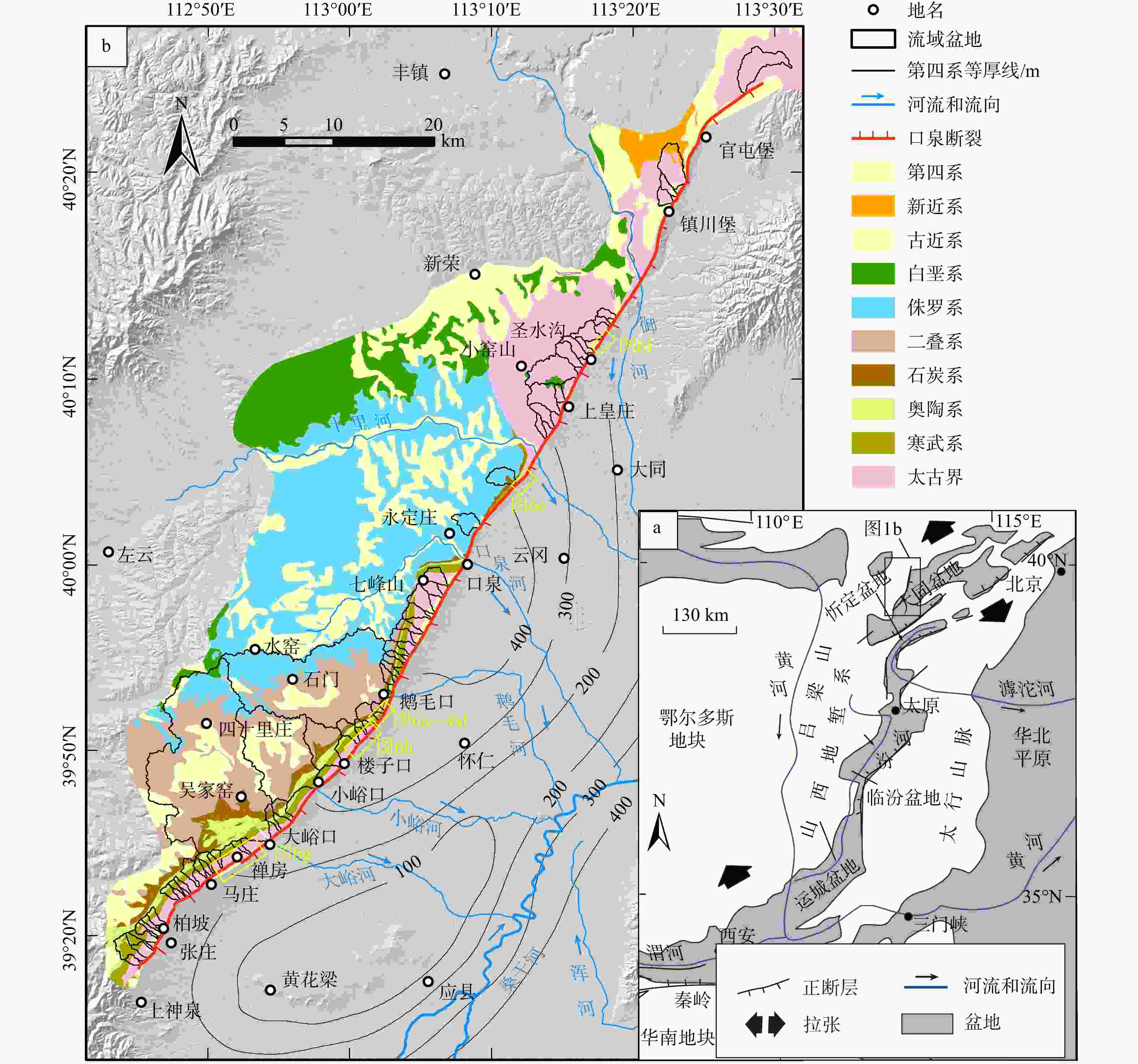
图 1 口泉断裂位置及构造概况
a—口泉断裂构造位置(据Ren et al.,2014修改);b—口泉断裂几何展布特征
Figure 1. Tectonics and fault geometry of the Kouquan Fault
(a) Structural location of the Kouquan Fault (modified after Ren et al., 2014); (b) Geometric distribution characteristics of the Kouquan Fault
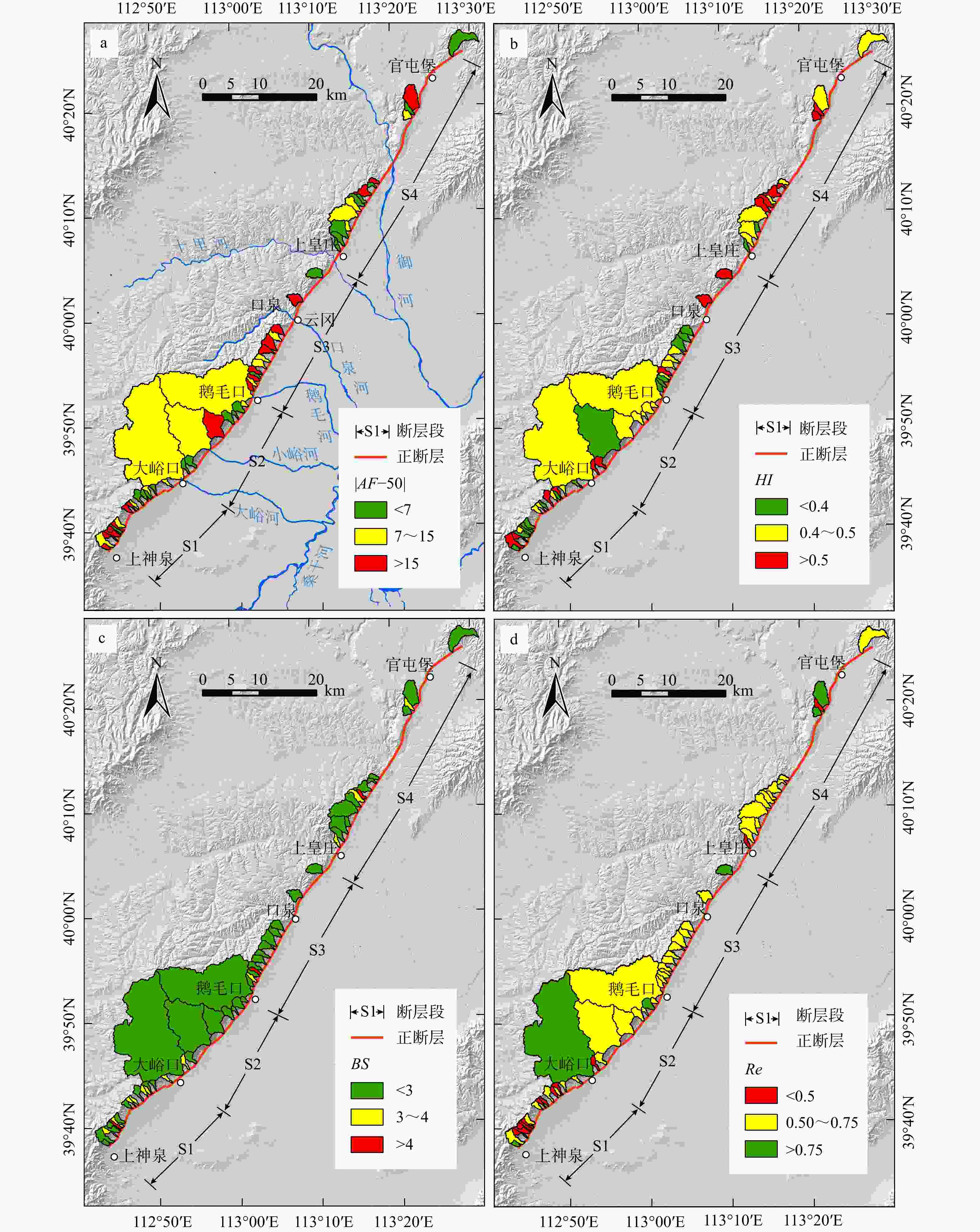
图 2 口泉断裂|$ AF $−50|、$ HI $、$ BS $、$ Re $指数沿断层分布情况
a—|$ AF $−50|指数等级分布;b—$ HI $指数等级分布;c—$ BS $指数等级分布;d—$ Re $指数等级分布
Figure 2. Distribution of the |$AF $−50|, $HI $, $BS $, and $Re $ indices along the Kouquan Fault in the study area
(a) Distribution of the |$AF $−50| index; (b) Distribution of the $ HI $ index; (c) Distribution of the $BS $ index; (d) Distribution of the $Re $ index
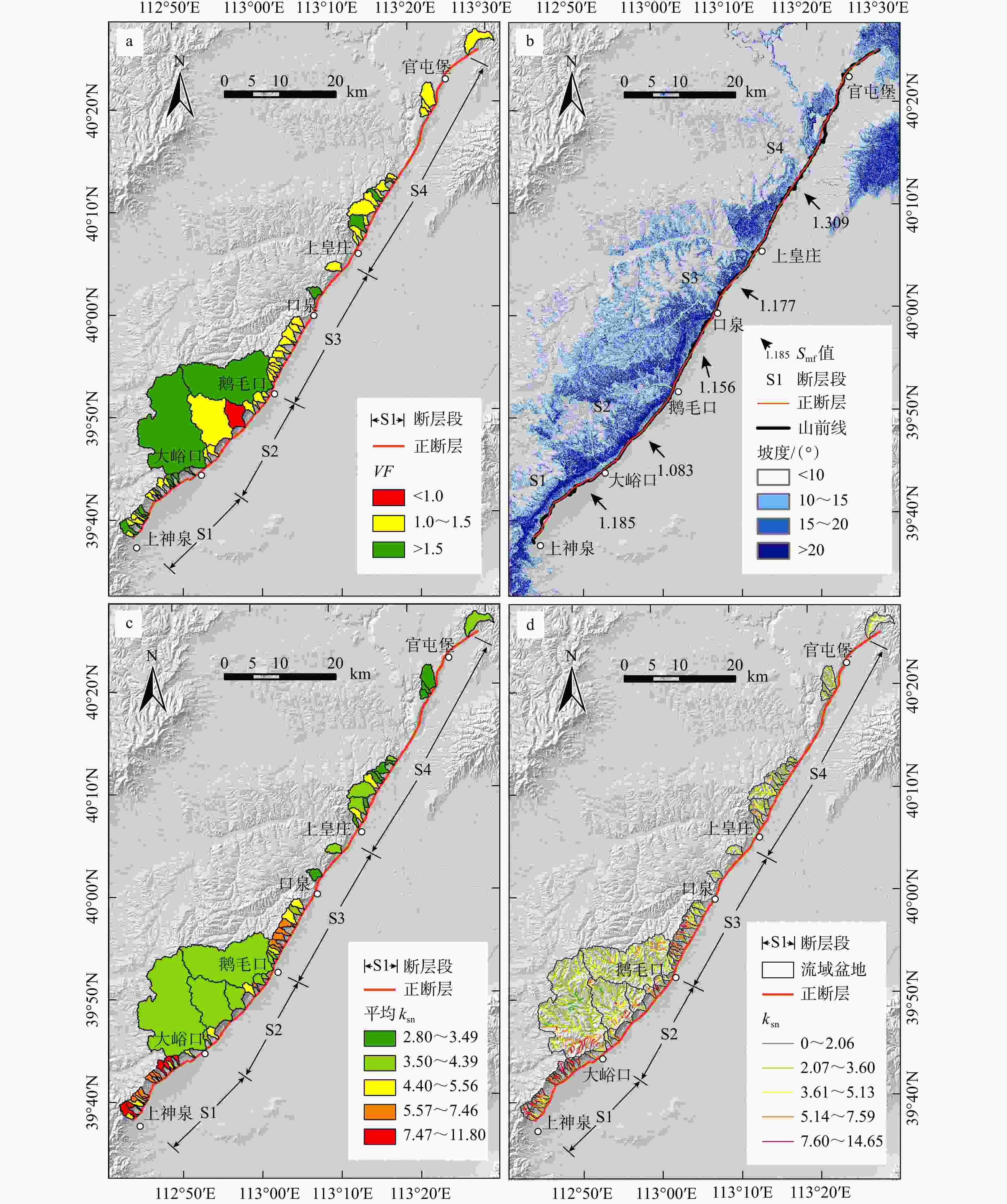
图 3 口泉断裂$ {V}_{\mathrm{f}} $、$ {S}_{\text{mf}} $、$ {k}_{\text{sn}} $指数沿断层分布情况
a—VF指数等级分布;b—$ {S}_{\text{mf}} $指数等级分布;c—流域平均$ {k}_{\text{sn}} $指数等级分布;d—$ {k}_{\text{sn}} $指数分布
Figure 3. Distribution of the$ {V}_{\mathrm{F}} $, ${S}_{\text{mf}} $, and ${k}_{\text{sn}} $ indices along the Kouquan Fault in the study area
(a) Distribution of the ${V}_{\mathrm{F}} $ index; (b) Distribution of the ${S}_{\text{mf}} $ index; (c) Distribution of the ${k}_{\text{sn}} $ index ((basin-averaged); (d) Distribution of the ${k}_{\text{sn}} $ index
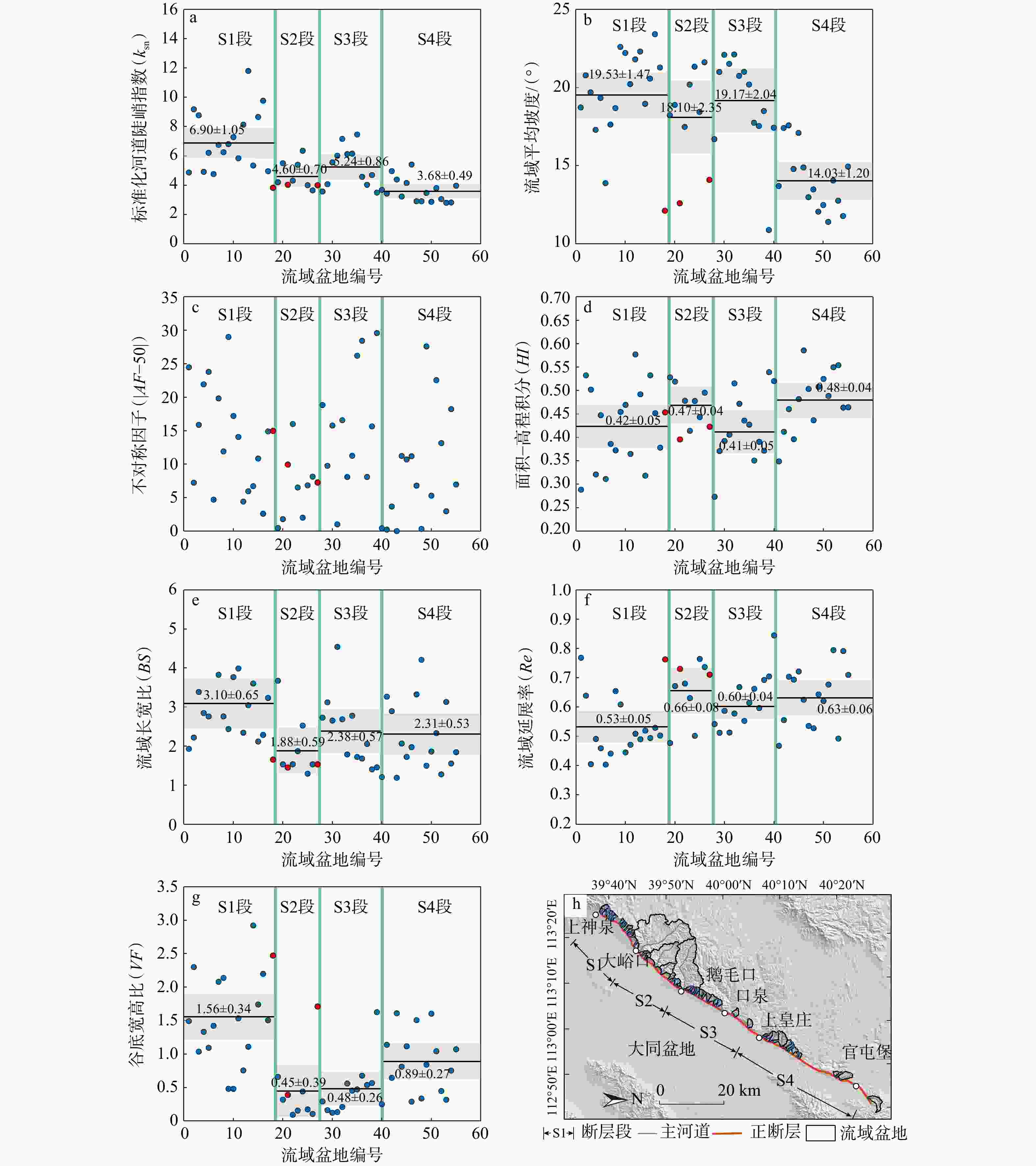
图 4 口泉断裂流域地貌指数及其分段特征
红色散点为面积大于50 km2的流域,散点图中数字为分段地貌指数的均值和置信区间a—$ {k}_{\text{sn}} $指数沿断层分布;b—流域平均坡度沿断层分布;c—$ {AF}_{} $指数沿断层分布;d— $ HI $指数沿断层分布;e—$ BS $指数沿断层分布;f—$ Re $指数沿断层分布;g—$ VF $指数沿断层分布;h—口泉断裂流域分布简图
Figure 4. Geomorphic indices and segmentation characteristics along the Kouquan Fault
(a) Distribution of the $ k_{\mathrm{sn}} $ index along the Kouquan Fault; (b) Distribution of the basin-averaged slope along the Kouquan Fault; (c) Distribution of the ${AF}_{} $ index along the Kouquan Fault; (d) Distribution of the $ HI $ index along the Kouquan Fault; (e) Distribution of the $BS $ index along the Kouquan Fault; (f) Distribution of the $Re $ index along the Kouquan Fault; (g) Distribution of the $VF $ index along the Kouquan Fault; (h) Drainage basins of the Kouquan Fault Red points represent watersheds with areas greater than 50 km2. The numbers in the scatter plot indicate the means and confidence intervals of the geomorphic indices by segment.
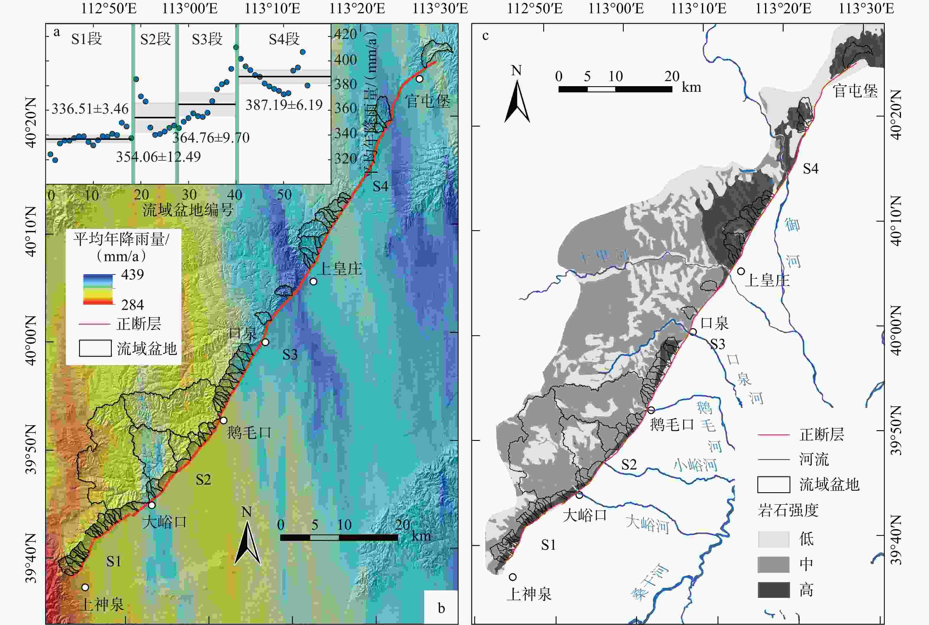
图 5 口泉断裂降雨及岩性强度沿断层分布
图a中数字为断层段平均年降雨量的均值和置信区间(单位:mm/a)a—流域平均降雨量沿断层分布;b—降雨情况分布;c—岩性强度分布
Figure 5. Distribution of precipitation and rock strength along the Kouquan Fault
(a) Distribution of basin-averaged precipitation along the fault; (b) Precipitation map of the study area; (c) Rock strength distribution The numbers in panel a represent the mean and confidence interval of the average annual rainfall for each fault segment (unit: mm/a).
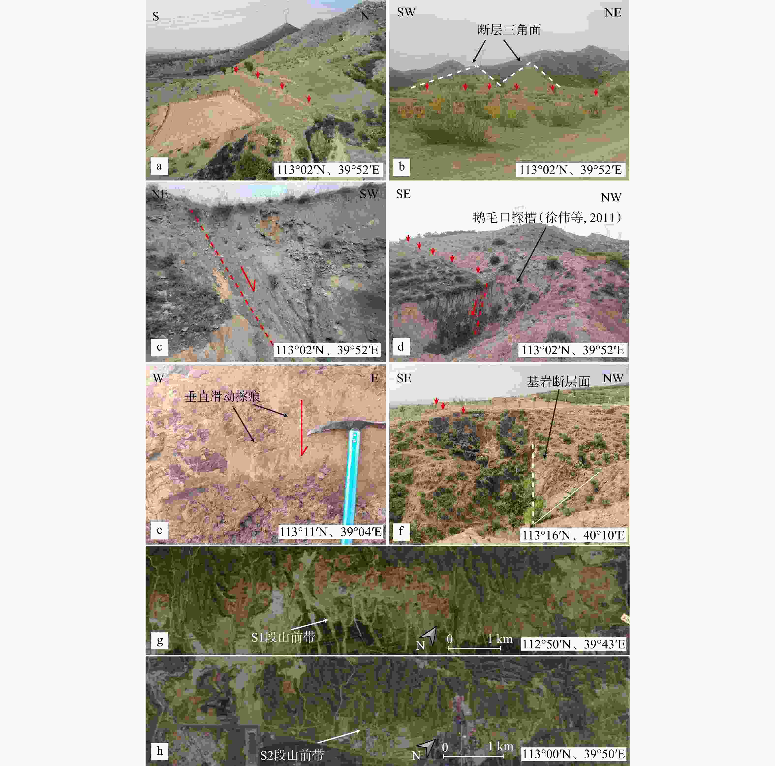
图 6 沿口泉断裂典型断错地貌与构造特征
a—S2—S3段鹅毛口探槽(徐伟等,2011)附近断层陡坎;b—S2—S3段鹅毛口探槽(徐伟等,2011)附近断层三角面;c—S2—S3段鹅毛口探槽(徐伟等,2011)内部;d—S2—S3段鹅毛口探槽(徐伟等,2011)附近断层陡坎;e—S3段北部兴王收费站附近断层面;f—S4南段圣水沟村附近基岩断层面跌水;g—S1段遥感影像(位于禅房村附近,马庄至大峪口之间);h—S2段遥感影像(位于悟道村附近,楼子口至鹅毛口之间)
Figure 6. Typical faulted landforms and structural features along the Kouquan Fault
(a) Fault scarp near the Emookou trench (Xu et al., 2011; segment S2–S3); (b) Triangular facets near the Emookou trench (Xu et al., 2011; segment S2–S3); (c) Interior view of the Emookou trench (Xu et al., 2011; segment S2–S3); (d) Fault scarp near the Emookou trench (Xu et al., 2011; segment S2–S3); (e) Fault surface near Xingwang Toll Station (northern S3 segment); (f) Bedrock fault waterfall near Shengshuigou Village (southern S4 segment); (g) Remote sensing image of segment S1 (near Chanfang Village, between Mazhuang and Dayukou); (h) Remote sensing image of segment S2 (near Wudao Village, between Louzikou and Emaokou)
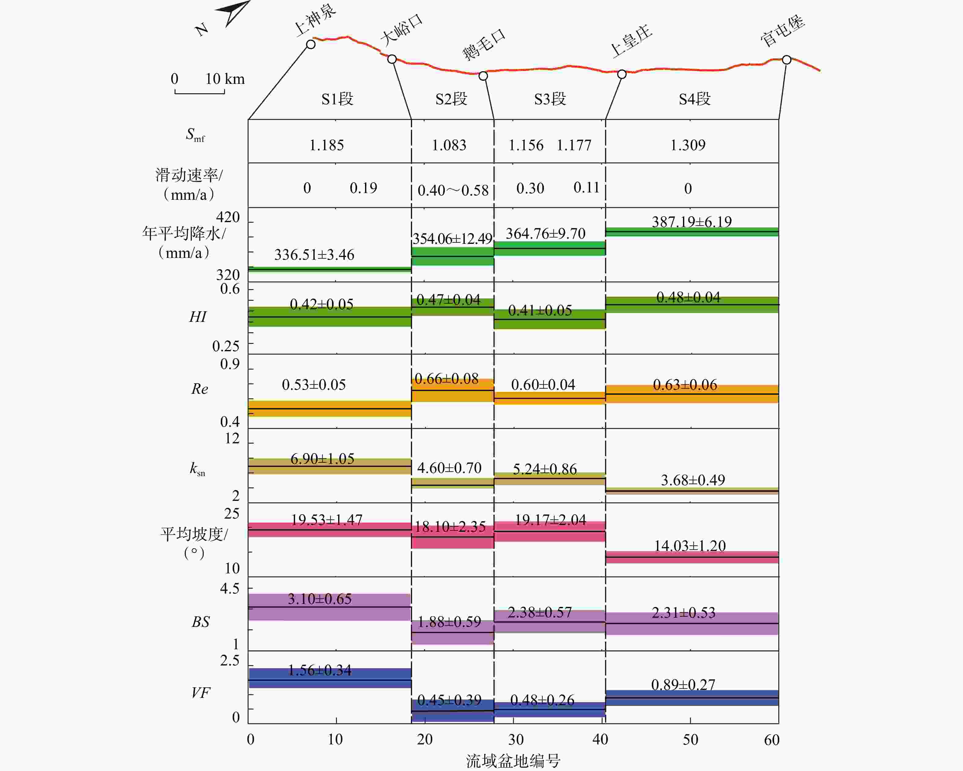
图 7 研究区地貌指数分段分布趋势
Figure 7. Distribution of geomorphic indices by segment in the study area
表 1 基于地貌指数的构造活动性分级(Luo et al.,2023;Zarei et al.,2024)
Table 1. Classification of tectonic activity based on geomorphic indices (Luo et al., 2023; Zarei et al., 2024)
地貌指数 低活动性 中活动性 高活动性 $ HI $ <0.4 [0.4,0.5] >0.5 |$ AF $−50| <7 [7,15] >15 $ BS $ <3 [3,4] >4 $ Re $ >0.75 [0.50,0.75] <0.5 $ VF $ >1.5 [1.0,1.5] <1 $ {S}_{\text{mf}} $ >1.4 <1.4 $ {k}_{\text{sn}} $ 与断层构造活动性正相关 流域坡度 与断层构造活动性正相关 注:HI—面积−高程积分;AF—流域不对称因子;$ BS $—流域形状指数;Re—流域延展率;$ VF $—谷底宽高比;$ {S}_{\text{mf}} $—山前弯曲度;$ {k}_{\text{sn}} $—标准化河道陡峭指数  下载: 导出CSV
表 2 口泉断裂流域盆地面积以及地貌指数
Table 2. Geomorphic indices and drainage areas along the Kouquan Fault
流域编号 流域面积 $ HI $ $ VF $ $ BS $ 流域平均$ {k}_{\text{sn}} $ |$ AF $−50| $ Re $ 流域平均坡度/(°) 1 0.98 0.29 1.49 1.93 4.87 24.48 0.77 18.73 2 3.73 0.53 2.30 2.22 9.18 7.23 0.64 20.78 3 1.45 0.50 1.04 3.39 8.77 15.88 0.40 19.69 4 1.73 0.32 1.33 2.85 4.91 21.93 0.49 17.29 5 1.24 0.45 1.09 2.76 6.21 23.80 0.46 19.33 6 0.96 0.31 1.42 7.51 4.76 4.70 0.40 13.88 7 1.09 0.39 2.08 3.83 6.75 19.83 0.44 17.63 8 1.68 0.37 2.14 2.76 6.25 11.91 0.65 18.68 9 1.35 0.45 0.48 2.44 6.81 29.01 0.61 22.60 10 0.84 0.47 0.48 3.77 7.28 17.20 0.45 22.22 11 0.94 0.36 1.53 3.99 5.84 14.07 0.47 20.22 12 2.21 0.58 0.76 2.34 8.13 4.41 0.51 21.80 13 1.15 0.49 1.11 3.05 11.80 5.96 0.49 22.31 14 0.84 0.32 2.92 3.60 5.34 6.72 0.52 18.96 15 1.31 0.53 1.74 2.12 8.66 10.84 0.49 20.57 16 1.03 0.45 2.20 2.29 9.77 2.60 0.53 23.42 17 1.02 0.38 1.50 3.23 4.95 14.90 0.50 21.29 18 149.93 0.45 2.47 1.66 3.83 14.95 0.76 12.12 19 1.62 0.53 0.66 3.67 4.20 0.46 0.48 18.23 20 2.47 0.52 0.32 1.53 5.50 1.79 0.67 18.89 21 50.14 0.40 0.39 1.45 4.03 9.95 0.73 12.59 22 13.13 0.48 0.09 1.54 4.31 16.00 0.68 17.48 23 2.86 0.41 0.16 1.87 5.40 6.52 0.63 20.19 24 0.79 0.48 0.44 2.53 6.35 2.01 0.50 21.34 25 2.95 0.44 0.17 1.29 4.00 6.84 0.76 18.44 26 0.93 0.50 0.11 1.53 3.65 8.14 0.74 21.62 27 103.04 0.42 1.71 1.53 4.00 7.29 0.71 14.09 28 1.51 0.27 0.29 2.73 3.57 18.84 0.54 16.70 29 1.20 0.37 0.16 3.12 4.07 9.76 0.51 21.00 30 1.54 0.39 0.12 2.65 5.56 15.78 0.59 22.10 31 1.04 0.41 0.13 4.54 6.01 1.01 0.51 21.52 32 2.01 0.52 0.21 2.69 7.16 16.57 0.58 22.12 33 2.60 0.47 0.56 1.79 6.12 8.09 0.67 20.75 34 1.85 0.44 0.45 2.78 6.15 11.26 0.55 21.01 35 2.65 0.43 0.47 1.72 7.46 26.20 0.61 20.20 36 3.96 0.35 0.68 1.68 4.57 28.44 0.66 17.75 37 2.28 0.39 0.54 2.05 4.02 8.09 0.60 17.54 38 2.78 0.37 0.57 1.40 4.69 15.65 0.69 18.50 39 3.58 0.54 1.63 1.46 3.49 29.59 0.70 10.88 40 4.02 0.52 0.25 1.21 3.68 0.44 0.84 17.43 41 1.33 0.35 1.14 3.27 3.43 0.23 0.47 13.70 42 2.67 0.41 0.64 2.90 4.96 3.68 0.56 17.41 43 6.34 0.46 1.61 1.19 4.39 0.01 0.70 17.58 44 1.34 0.40 0.81 2.07 3.23 11.23 0.69 14.79 45 10.68 0.48 1.12 1.72 4.15 10.71 0.72 17.10 46 3.44 0.59 0.29 1.97 5.41 11.19 0.62 14.89 47 2.56 0.50 1.51 3.32 2.91 6.80 0.54 12.98 48 1.14 0.44 0.34 4.21 2.90 0.33 0.53 13.48 49 3.30 0.51 0.84 1.50 3.47 27.60 0.64 12.05 50 0.96 0.52 1.60 1.86 2.86 5.29 0.62 12.48 51 1.29 0.49 1.04 2.33 3.80 22.56 0.68 11.40 52 1.97 0.55 0.45 1.28 3.05 13.15 0.79 14.05 53 1.67 0.55 0.32 3.13 2.80 2.97 0.49 12.76 54 8.32 0.46 0.75 1.55 2.82 18.24 0.79 11.78 55 8.59 0.46 1.07 1.84 3.97 6.96 0.71 14.94 HI—面积−高程积分;AF—流域不对称因子;$ BS $—流域形状指数;Re—流域延展率;$ VF $—谷底宽高比;$ {k}_{\text{sn}} $—标准化河道陡峭指数
下载: 导出CSV
表 3 口泉断裂各分段滑动速率(徐伟等,2011)与部分地貌指数对比
Table 3. Slip rate (Xu et al., 2011) and geomorphic indices in different segments of the Kouquan Fault
断层段 南段 中段 北段 上神泉—柏坡 柏坡—大峪口 大峪口—鹅毛口 鹅毛口—口泉 口泉—上皇庄 上皇庄—官屯堡 T2阶地垂直位移/m 0 5.70 12.00~17.50 9.00 3.20 0 滑动速率/(mm/a) 0 0.19 0.40~0.58 0.30 0.11 0 $ {k}_{\text{sn}} $ 6.09 4.60 5.24 3.68 $ VF $ 1.56 0.45 0.48 0.89 $ {S}_{\text{mf}} $ 1.18 1.08 1.156 1.17 1.31 $ VF $—谷底宽高比;$ {S}_{\text{mf}} $—山前弯曲度;$ {k}_{\text{sn}} $—标准化河道陡峭指数
下载: 导出CSV
表 4 岩石强度分类(Selby,1980;梁欧博等,2018;Topal,2019;Ma et al.,2024)
Table 4. Rock strength classification (Selby, 1980; Liang et al., 2018; Topal, 2019; Ma et al., 2024)
抗侵蚀强度 类别 低 强风化变砂岩、微风化页岩、泥质砂岩、冲积堆积地层等 中 中等风化的变砂岩、微风化的板岩、千枚岩和火山碎屑岩等 高 火成岩类、砂岩、灰岩、白云岩等
下载: 导出CSV
-
[1] DING X W, HUO K, FENG K Y, et al. , 2021. Study on fault distribution characteristics and activity of Jiaocheng section of Kouquan fault[J]. Earthquake Research in Shanxi(1): 15-19. (in Chinese with English abstract) [2] EL HAMDOUNI R, IRIGARAY C, FERNÁNDEZ T et al., 2008. Assessment of relative active tectonics, southwest border of the Sierra Nevada (southern Spain)[J]. Geomorphology, 96(1-2): 150-173. doi: 10.1016/j.geomorph.2007.08.004 [3] FLINT J J, 1974. Stream gradient as a function of order, magnitude, and discharge[J]. Water Resources Research, 10(5): 969-973. doi: 10.1029/WR010i005p00969 [4] HARE P H, GARDNER T W M, 1985. Geomorphic indicators of vertical neotectonism along converging plate margins, Nicoya Peninsula, Costa Rica[M]//MORISAWA M, HACH J T. Tectonic geomorphology. Boston: Allen and Unwin: 75-104. [5] JIN W Z, TANG L J, YANG K M, et al., 2010. Segmentation of the Longmen mountains thrust belt, western Sichuan foreland Basin, SW China[J]. Tectonophysics, 485(1-4): 107-121. doi: 10.1016/j.tecto.2009.12.007 [6] KELLER E A, PINTER N, 2002. Active tectonics: earthquakes, uplift, and landscape[M]. 2nd ed. Upper Saddle River: Prentice Hall. [7] KIRBY E, WHIPPLE K X, TANG W Q. et al., 2003. Distribution of active rock uplift along the eastern margin of the Tibetan Plateau: inferences from bedrock channel longitudinal profiles[J]. Journal of Geophysical Research: Solid Earth, 108(B4): 2217. [8] KIRBY E, WHIPPLE K X, 2012. Expression of active tectonics in erosional landscapes[J]. Journal of Structural Geology, 44: 54-75. doi: 10.1016/j.jsg.2012.07.009 [9] KLINGER Y, MICHEL R, KING G C P, 2006. Evidence for an earthquake barrier model from Mw~7.8 Kokoxili (Tibet) earthquake slip-distribution[J]. Earth and Planetary Science Letters, 242(3-4): 354-364. doi: 10.1016/j.epsl.2005.12.003 [10] KRYSTOPOWICZ N J, SCHOENBOHM L M, RIMANDO J, et al., 2020. Tectonic geomorphology and Plio-Quaternary structural evolution of the Tuzgölü fault zone, Turkey: implications for deformation in the interior of the Central Anatolian Plateau[J]. Geosphere, 16(5): 1107-1124. doi: 10.1130/GES02175.1 [11] LI H Q, YUAN D Y, SU Q, et al., 2023. Geomorphic features of the Menyuan basin in the Qilian Mountains and its tectonic significance[J]. Journal of Geomechanics, 29(6): 824-841. (in Chinese with English abstract) [12] LI Y H, WANG Q L, CUI D X, et al., 2013. Research on fault motion and segmentation characteristic of Kouquan fault in Datong basin by numerical simulation[J]. Journal of Geodesy and Geodynamics, 33(4): 9-12. (in Chinese with English abstract) [13] LIANG O B, REN J J, LÜ Y W, 2018. The response of fluvial geomorphologic characteristics of the Fujiang drainage basin to activity of the Huya fault zone[J]. Seismology and geology, 40(1): 42-56. (in Chinese with English abstract) [14] LIFTON N A, CHASE C G, 1992. Tectonic, climatic and lithologic influences on landscape fractal dimension and hypsometry: implications for landscape evolution in the San Gabriel Mountains, California[J]. Geomorphology, 5(1-2): 77-114. doi: 10.1016/0169-555X(92)90059-W [15] LUO Q X, SCHOENBOHM L, RIMANDO J, et al., 2023. Morphometric analysis of the North Liuleng Shan Fault in the northern Shanxi Graben System, China: insights into active deformation pattern and fault evolution[J]. Geomorphology, 440: 108862. doi: 10.1016/j.geomorph.2023.108862 [16] LUO X H, YANG M H, JIA C Y, et al., 2019. Structural features of late mesozoic Kouquan fault zone, northern Shanxi province[J]. Geoscience, 33(3): 551-560. (in Chinese with English abstract) [17] MA B Q, LI K, WU W M, 2000. Segmentation of the Daqingshan Piedmont fault[C]//Bulletin of the Institute of Crustal Dynamics(13). Beijing: Seismological Press, 53-60. (in Chinese with English abstract) [18] MA Y J, HUANG W L, ZHANG J L, et al., 2024. Tectonic activity analysis of the Laji-Jishi Shan fault zone: insights from geomorphic indices and crustal deformation data[J]. Remote Sensing, 16(20): 3770. doi: 10.3390/rs16203770 [19] MACHETTE M N, PERSONIUS S F, NELSON A R, et al., 1991. The Wasatch fault zone, utah: segmentation and history of Holocene earthquakes[J]. Journal of Structural Geology, 13(2): 137-149. doi: 10.1016/0191-8141(91)90062-N [20] MAHMOOD S A, GLOAGUEN R, 2012. Appraisal of active tectonics in Hindu Kush: insights from DEM derived geomorphic indices and drainage analysis[J]. Geoscience Frontiers, 3(4): 407-428. doi: 10.1016/j.gsf.2011.12.002 [21] MATOS A, DILTS T E, 2019. Hypsometric integral toolbox for ArcGIS. University of Nevada Reno[EB/OL]. (2019-12-06). https://www.arcgis.com/home/item.html?id=23a2dd9d127f41c195628457187d4a54. [22] MITCHELL N A, YANITES B J, 2019. Spatially variable increase in rock uplift in the northern U. S. cordillera recorded in the distribution of river knickpoints and incision depths[J]. Journal of Geophysical Research: Earth Surface, 124(5): 1238-1260. doi: 10.1029/2018JF004880 [23] NITHESHNIRMAL S, THILAGARAJ P, RAHAMAN S A, et al., 2019. Erosion risk assessment through morphometric indices for prioritisation of Arjuna watershed using ALOS-PALSAR DEM[J]. Modeling Earth Systems and Environment, 5(3): 907-924. doi: 10.1007/s40808-019-00578-y [24] NTOKOS D, LYKOUDI E, RONDOYANNI T, 2016. Geomorphic analysis in areas of low-rate neotectonic deformation: South Epirus (Greece) as a case study[J]. Geomorphology, 263: 156-169. doi: 10.1016/j.geomorph.2016.04.005 [25] PEDRERA A, PÉREZ-PEÑA J V, GALINDO-ZALDÍVAR J et al., 2009. Testing the sensitivity of geomorphic indices in areas of low-rate active folding (eastern Betic Cordillera, Spain)[J]. Geomorphology, 105(3-4): 218-231. doi: 10.1016/j.geomorph.2008.09.026 [26] PENG S Z, 2020. 1-km monthly precipitation dataset for China (1901-2024)[EB/OL]. National Tibetan Plateau / Third Pole Environment Data Center. https://doi.org/10.5281/zenodo.3114194. [27] RAMÍREZ-HERRERA M T, 1998. Geomorphic assessment of active tectonics in the Acambay graben, Mexican Volcanic Belt[J]. Earth Surface Processes and Landforms, 23(4): 317-332. doi: 10.1002/(SICI)1096-9837(199804)23:4<317::AID-ESP845>3.0.CO;2-V [28] REN J J, ZHANG S M, MEIGS A J, et al., 2014. Tectonic controls for transverse drainage and timing of the Xin-Ding paleolake breach in the upper reach of the Hutuo River, north China[J]. Geomorphology, 206: 452-467. doi: 10.1016/j.geomorph.2013.10.016 [29] RIMANDO J M, SCHOENBOHM L M, 2020. Regional relative tectonic activity of structures in the Pampean flat slab segment of Argentina from 30 to 32°S[J]. Geomorphology, 350: 106908. doi: 10.1016/j.geomorph.2019.106908 [30] ROCKWELL T K, KELLER E A, JOHNSON D L, 1985. Tectonic geomorphology of alluvial fans and mountain fronts near Ventura, California[M]// MORISAWA M, HACK J T, eds. Tectonic Geomorphology: Proceedings of the 15th Annual Geomorphology Symposium. Boston: Allen and Unwin Publishers, 183–207. [31] SABER R, CAGLAYAN A, ISIK V, 2018. Relative tectonic activity assessment and kinematic analysis of the North Bozgush fault Zone, NW Iran[J]. Journal of Asian Earth Sciences, 164: 219-236. doi: 10.1016/j.jseaes.2018.06.023 [32] SCHUMM S A, 1956. Evolution of drainage systems and slopes in badlands at Perth Amboy, new jersey[J]. GSA Bulletin, 67(5): 597-646. [33] SCHWANGHART W, KUHN N J, 2010. TopoToolbox: a set of Matlab functions for topographic analysis[J]. Environmental Modelling & Software, 25(6): 770-781. doi: 10.1016/j.envsoft.2009.12.002 [34] SELBY M J, 1980. A rock mass strength classification for geomorphic purposes: with tests from Antarctica and New Zealand[J]. Zeitschrift für Geomorphologie, 24(1): 31-51. doi: 10.1127/zfg/24/1984/31 [35] SHARMA G, CHAMPATI RAY P K, MOHANTY S, 2018. Morphotectonic analysis and GNSS observations for assessment of relative tectonic activity in Alaknanda basin of Garhwal Himalaya, India[J]. Geomorphology, 301: 108-120. doi: 10.1016/j.geomorph.2017.11.002 [36] SHEN Q, QIAO X J, WANG Q, et al., 2013. Analysis of accuracy multi-source remote sensing techniques on high-precision digital elevation model reconstruction after Wenchuan earthquake[J]. Progress in Geophysics, 28(4): 1785-1794. (in Chinese with English abstract) [37] SHI X H, YANG Z, DONG Y P, et al., 2020. Geomorphic indices and longitudinal profile of the Daba Shan, northeastern Sichuan Basin: evidence for the late Cenozoic eastward growth of the Tibetan Plateau[J]. Geomorphology, 353: 107031. doi: 10.1016/j.geomorph.2020.107031 [38] SONG A, REN J J, LIU A C, et al., 2023. Active seismic surveys based on distributed acoustic sensing in near-surface active fault exploration: a test in Datong Basin, North China[J]. Journal of Applied Geophysics, 213: 105041. doi: 10.1016/j.jappgeo.2023.105041 [39] STRAHLER A N, 1952. Hypsometric (area-altitude) analysis of erosional topography[J]. GSA Bulletin, 63(11): 1117-1142. [40] STRAHLER A N, 1964. Quantitative geomorphology of drainage basins and channel networks[M]//CHOW V. Handbook of applied hydrology. New York: McGraw Hill [41] TOPAL S, 2019. Evaluation of relative tectonic activity along the Priene-Sazlı Fault (Söke Basin, southwest Anatolia): insights from geomorphic indices and drainage analysis[J]. Journal of Mountain Science, 16(4): 909-923. doi: 10.1007/s11629-018-5274-x [42] WANG E, SHI X H, WANG G, et al., 2011. Structural control on the topography of the Laji–Jishi and Riyue Shan belts in the NE margin of the Tibetan Plateau: facilitation of the headward propagation of the Yellow River system[J]. Journal of Asian Earth Sciences, 40(4): 1002-1014. doi: 10.1016/j.jseaes.2010.05.007 [43] WANG P, SONG J Y, FENG S Y, et al., 2024. The characteristics of the fluvial geomorphic parameters and its formed dynamic analysis for the Seerteng Mountain, northern margin of the Hetao basin[J]. Acta Geologica Sinica, 98(4): 1129-1145. (in Chinese with English abstract) [44] WANG X, SONG M Q, WANG L, et al., 2015. Study on crustal velocity structure beneath Kouquan fault and adjacent area[J]. Seismology and Geology, 37(4): 939-952. (in Chinese with English abstract) [45] WESNOUSKY S G, 2006. Predicting the endpoints of earthquake ruptures[J]. Nature, 444(7117): 358-360. doi: 10.1038/nature05275 [46] WOBUS C, WHIPPLE K X, KIRBY E, et al. , 2006. Tectonics from topography: procedures, promise, and pitfalls[M]//WILLETT S D, HOVIUS N, BRANDON M T, et al. Tectonics, climate, and landscape evolution. Boulder: Geological Society of America. [47] WU Z H, ZHENG W J, REN J J, et al., 2024. Active tectonics and strong earthquakes: a preface for the special issue[J]. Journal of Geomechanics, 30(2): 181-188. (in Chinese with English abstract) [48] XIE X S, JIANG W L, WANG R, et al., 2003. Holocene paleo-seismic activities on the Kouquan fault zone, Datong basin, Shanxi province[J]. Seismology and Geology, 25(3): 359-374. (in Chinese with English abstract) [49] XU Q R, DONG Y P, XIE Z P, et al., 2024. Tectonic and geomorphological characteristics of Laoyingshan in the eastern Sichuan-Yunnan block: insights into the uplift and rotation of the blocks[J]. Journal of Geomechanics, 30(4): 535-546. (in Chinese with English abstract) [50] XU W, LIU X D, ZHANG S M, 2011. Late quaternary faulted landforms and determination of slip rates of the middle part of Kouquan fault[J]. Seismology and Geology, 33(2): 335-346. (in Chinese with English abstract) [51] XU X W, WEN X Z, YU G H, et al., 2005. Average slip rate, earthquake rupturing segmentation and recurrence behavior on the Litang fault zone, western Sichuan Province, China[J]. Science in China Series D: Earth Sciences, 48(8): 1183-1196. doi: 10.1360/04yd0072 [52] YANG Y, QIN X, SHI W, et al., 2022. Segmentation of the active Liumugao Fault, NE Tibetan Plateau as revealed by DEM-derived geomorphic indices[J]. Geosystems and Geoenvironment, 1(3): 100056. doi: 10.1016/j.geogeo.2022.100056 [53] YUAN D Y, LIU B C, LÜ T Y, et al., 1998. Study on the segmentation in east segment of the northern Qilianshan fault zone[J]. Northwestern Seismological Journal, 20(4): 27-34. (in Chinese with English abstract) [54] ZAREI E, FAGHIH A, SOLEIMANI M, et al., 2024. Assessment of relative tectonic activity in the Lar region, Zagros Fold-Thrust Belt, SW Iran: insights from geomorphometric analysis[J]. Earth Surface Processes and Landforms, 49(3): 1199-1213. doi: 10.1002/esp.5753 [55] ZHANG B, WANG A G, TIAN Q J, et al., 2022. Identifying fault lineament based on ALOS-PALSAR DEM: a case study from the west Qinling Mountains[J]. Seismology and Geology, 44(1): 130-149. (in Chinese with English abstract) [56] ZHENG W J, SUN X, LEI Q Y, et al., 2024. Late Quaternary tectonic activity and strong earthquake generation mechanism around the boundary zone of the Ordos active-tectonic block, central China[J]. Journal of Geomechanics, 30(2): 206-224. (in Chinese with English abstract) [57] ZHOU Z Q, WHITTAKER A C, BELL R E, et al., 2024. Unravelling tectonic and lithological effects on transient landscapes in the Gulf of Corinth, Greece[J]. Basin Research, 36(5): e12901. doi: 10.1111/bre.12901 [58] 丁学文, 霍魁, 冯凯宇, 等, 2021. 口泉断裂郊城段断裂展布特征及其活动性研究[J]. 山西地震(1): 15-19. [59] 李红强, 袁道阳, 苏琦, 等, 2023. 祁连山内部门源盆地地貌特征及构造意义[J]. 地质力学学报, 29(6): 824-841. [60] 李煜航, 王庆良, 崔笃信, 等, 2013. 大同盆地口泉断裂的活动性及分段特征的数值模拟[J]. 大地测量与地球动力学, 33(4): 9-12. [61] 梁欧博, 任俊杰, 吕延武, 2018. 涪江流域河流地貌特征对虎牙断裂带活动性的响应[J]. 地震地质, 40(1): 42-56. doi: 10.3969/j.issn.0253-4967.2018.01.004 [62] 罗晓华, 杨明慧, 贾春阳, 等, 2019. 晋北地区口泉断裂带晚中生代分段构造特征[J]. 现代地质, 33(3): 551-560. doi: 10.19657/j.geoscience.1000-8527.2019.03.08 [63] 马保起, 李克, 吴卫民. 2000. 大青山山前断裂活动的分段性研究[C]//地壳构造与地壳应力文集(13). 北京: 地震出版社, 53-60. [64] 沈强, 乔学军, 王琪, 等, 2013. 多源遥感技术在汶川震后高精度数字高程模型重建中的精度分析[J]. 地球物理学进展, 28(4): 1785-1794. doi: 10.6038/pg20130419 [65] 王平, 宋金跃, 酆少英, 等, 2024. 河套盆地北缘色尔滕山河流地貌参数特征及其成因分析[J]. 地质学报, 98(4): 1129-1145. [66] 王霞, 宋美琴, 王亮, 等, 2015. 口泉断裂及其邻近地区的地壳速度结构[J]. 地震地质, 37(4): 939-952. [67] 吴中海, 郑文俊, 任俊杰, 等, 2024. 活动构造与强震: 专辑序言[J]. 地质力学学报, 30(2): 181-188. doi: 10.12090/j.issn.1006-6616.20243002 [68] 谢新生, 江娃利, 王瑞, 等, 2003. 山西大同盆地口泉断裂全新世古地震活动[J]. 地震地质, 25(3): 359-374. [69] 徐琴如, 董有浦, 谢志鹏, 等, 2024. 川滇地块东部老鹰山的构造地貌特征及其揭示的地块隆升和旋转运动[J]. 地质力学学报, 30(4): 535-546. doi: 10.12090/j.issn.1006-6616.2023087 [70] 徐伟, 刘旭东, 张世民, 2011. 口泉断裂中段晚第四纪以来断错地貌及滑动速率确定[J]. 地震地质, 33(2): 335-346. doi: 10.3969/j.issn.0253-4967.2011.02.007 [71] 袁道阳, 刘百篪, 吕太乙, 等, 1998. 北祁连山东段活动断裂带的分段性研究[J]. 西北地震学报, 20(4): 27-34. [72] 张波, 王爱国, 田勤俭, 等, 2022. 基于ALOS-PALSAR DEM的山体阴影图识别断裂线性: 以西秦岭地区为例[J]. 地震地质, 44(1): 130-149. [73] 郑文俊, 孙鑫, 雷启云, 等, 2024. 鄂尔多斯活动地块边界带第四纪晚期构造活动特征及强震孕育机制[J]. 地质力学学报, 30(2): 206-224. -

 下载:
下载:




计量
- 文章访问数: 468
- HTML全文浏览量: 155
- PDF下载量: 179
- 被引次数: 0
