

InSAR coseismic deformation field and tectonic implications of the 2023 MS 5.5 Subei Earthquake, Gansu, China
-
摘要: 2023年10月24日甘肃酒泉市肃北县发生了MS 5.5地震,震中位于青藏高原前缘祁连山地震带上。为深入探究此次地震的发震机理及与构造应力场的关系,利用升、降轨Sentinel-1数据获取了此次肃北MS 5.5地震的InSAR同震形变场,并基于均匀位错模型确定了发震断层参数;在此基础上,采用分布式滑动反演方法获得了发震断层的精细滑动分布,并进一步分析了肃北MS 5.5地震引起的库仑应力荷载及区域震间应变率变化。研究结果表明:此次地震产生的地表形变场在InSAR升、降轨视线向分别达到12 cm、9 cm,形变主要表现为地表隆升;发震断层为位于疏勒南山断裂与中祁连北缘断裂之间的一条隐伏断层,走向角约为166.97°,倾角约为68.69°,滑动角约为110.39°;断层滑动主要集中在1.2~4.9 km深度范围内,最大滑动量为0.58 m,发生于地下约2.56 km深处;反演得到的矩震级为MW 5.6,同震破裂以逆冲为主兼少许右旋走滑分量。此次地震事件导致了中祁连北缘断裂与疏勒南山断裂之间区域及疏勒河断裂带北侧地区出现一定程度的库仑应力加载特征。同时,区域面应变率在震间呈现明显挤压态势,在震区北侧面应变与最大剪应变率较高,历史地震多发生于应变高值向低值变化的梯度带上,结合区域的应力分布特征表明,该地区未来地震的危险性不容忽视。Abstract:
Objective On October 24, 2023, an MS 5.5 earthquake occurred in Subei County, Jiuquan City, Gansu Province. The epicenter was located in the Qilian mountain seismic belt at the northeastern margin of the Qinghai-Tibet Plateau. Understanding the seismogenic mechanism of this earthquake and its relationship with the tectonic stress field is crucial for analyzing the seismic hazard in the region. Methods The InSAR coseismic deformation field of the MS5.5 earthquake in Subei was obtained using ascending and descending Sentinel-1 SAR data, and the parameters of the seismogenic fault were determined based on a uniform slip model. Subsequently, a distributed slip inversion method was applied to obtain a detailed slip distribution of the seismogenic fault. Furthermore, the earthquake-induced changes in the Coulomb stress and the regional interseismic strain rate were determined. Results The results indicate that the surface deformation values generated by this earthquake reached 12 cm and 9 cm in the ascending and descending InSAR line of sight, respectively. The deformation primarily manifests as surface uplift; the seismogenic fault is a concealed fault located between the Shule Nanshan Fault and the northern margin fault of the Central Qilian, the strike is approximately 166.97°, the dip angle is around 68.69°, and the slip angle is about 110.39°; the fault slip is primarily concentrated within the depth range of 1.2 km to 4.9 km, with a maximum slip of 0.58 m occurring at a depth of approximately 2.56 km; the moment magnitude obtained from the inversion is MW 5.6, and the coseismic rupture is primarily characterized by thrust motion with a minor component of right-lateral strike-slip. This seismic event resulted in regional Coulomb stress changes between the northern margin fault of the Central Qilian and the Shule Nanshan Fault, as well as in the northern area of the Shule River Fault Zone. Additionally, the regional surface strain rate exhibited a distinct compressive trend before the earthquake, with higher surface strain and maximum shear strain rates observed on the northern side of the seismic zone. Conclusion The continuous accumulation of strain leads to an increased seismic hazard, with historical earthquakes often occurring in gradient zones where strain values transition from high to low. Considering the regional strain distribution characteristics and seismic activity, the seismic hazard in this area remains significant in the future and should not be overlooked. [Significance] The research findings have a certain guiding significance for understanding the tectonic background of the Qilian Block and its seismic hazard. -
Key words:
- Qilian Block /
- Subei MS 5.5 Earthquake /
- InSAR /
- slip distribution /
- Coulomb stress change /
- strain rate
-
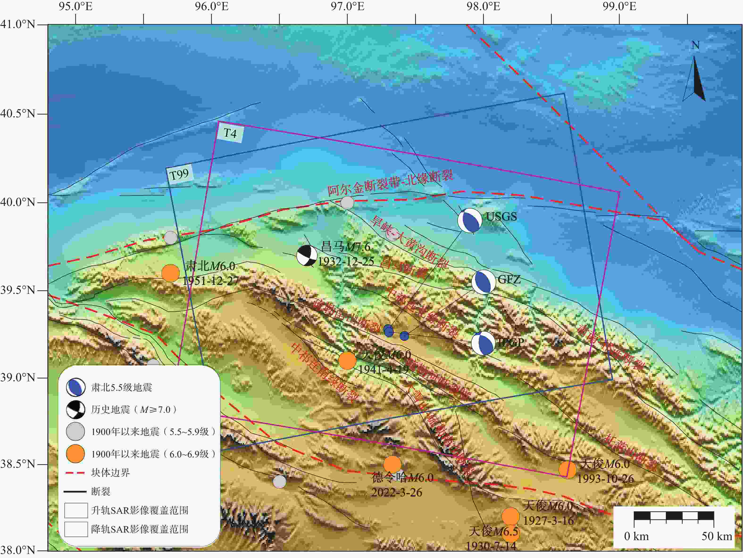
图 1 2023年肃北MS 5.5地震的区域构造背景
断裂数据来源于Wu et al.,2024;块体边界数据来源于王辉等,2003;蓝色沙滩球分别表示USGS (美国地质调查局)、GFZ(德国地学中心)、IPGP(法国巴黎地球物理研究中心)公布的震源机制解结果
Figure 1. Regional tectonic setting of the 2023 Subei MS5.5 earthquake
Fault data from Wu et al. (2024), block boundary data from Wang et al. (2003), blue beach balls represent the focal mechanism solution results published by the United States Geological Survey (USGS), the German Research Centre for Geosciences (GFZ), and the Institut de Physique du Globe de Paris (IPGP).
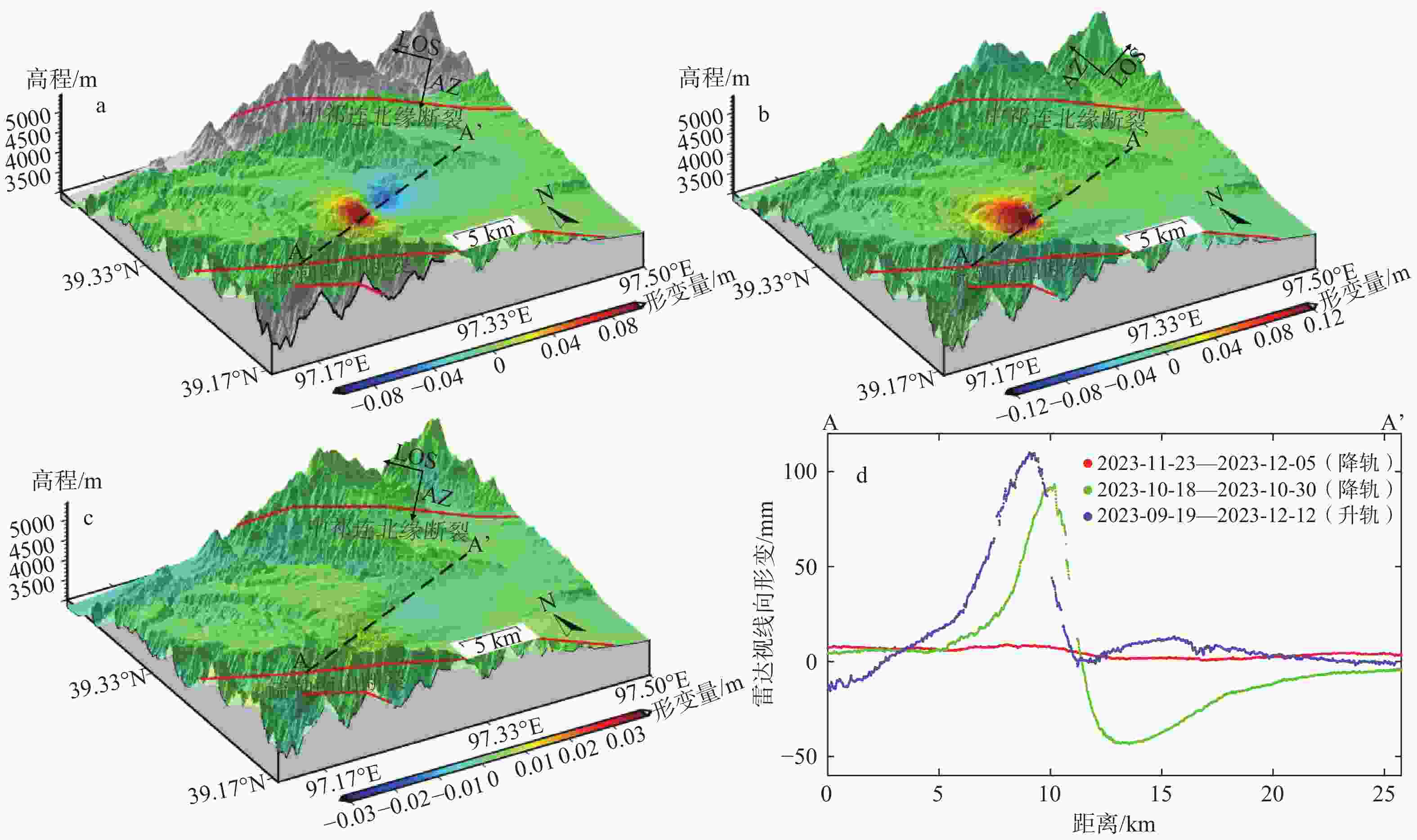
图 2 InSAR升、降轨同震形变场
红色线段表示周边断裂;黑色虚线AA’表示提取的剖线位置;箭头AZ(Azimuth)表示卫星飞行方向;箭头LOS(Line-of-sight)表示雷达的视线方向a—10月24日肃北MS 5.5地震降轨形变场;b—10月24日肃北MS 5.5地震升轨形变场;c—12月1日肃北MS 5.0地震降轨形变场;d—剖面形变
Figure 2. Coseismic deformation fields from InSAR ascending and descending tracks (a) Deformation field from the descending track of the Subei MS5.5 Earthquake on October 24; (b) Deformation field from the ascending track of the Subei MS5.5 Earthquake on October 24; (c) Deformation field from the descending track of the Subei MS5.0 Earthquake on December 1; (d) Deformation profiles
The red line segments represent the surrounding faults, black dashed line AA’ indicates the location of the extracted profile, the arrow labeled AZ (Azimuth) shows the satellite flight direction, and the arrow labeled LOS indicates the radar line-of-sight direction
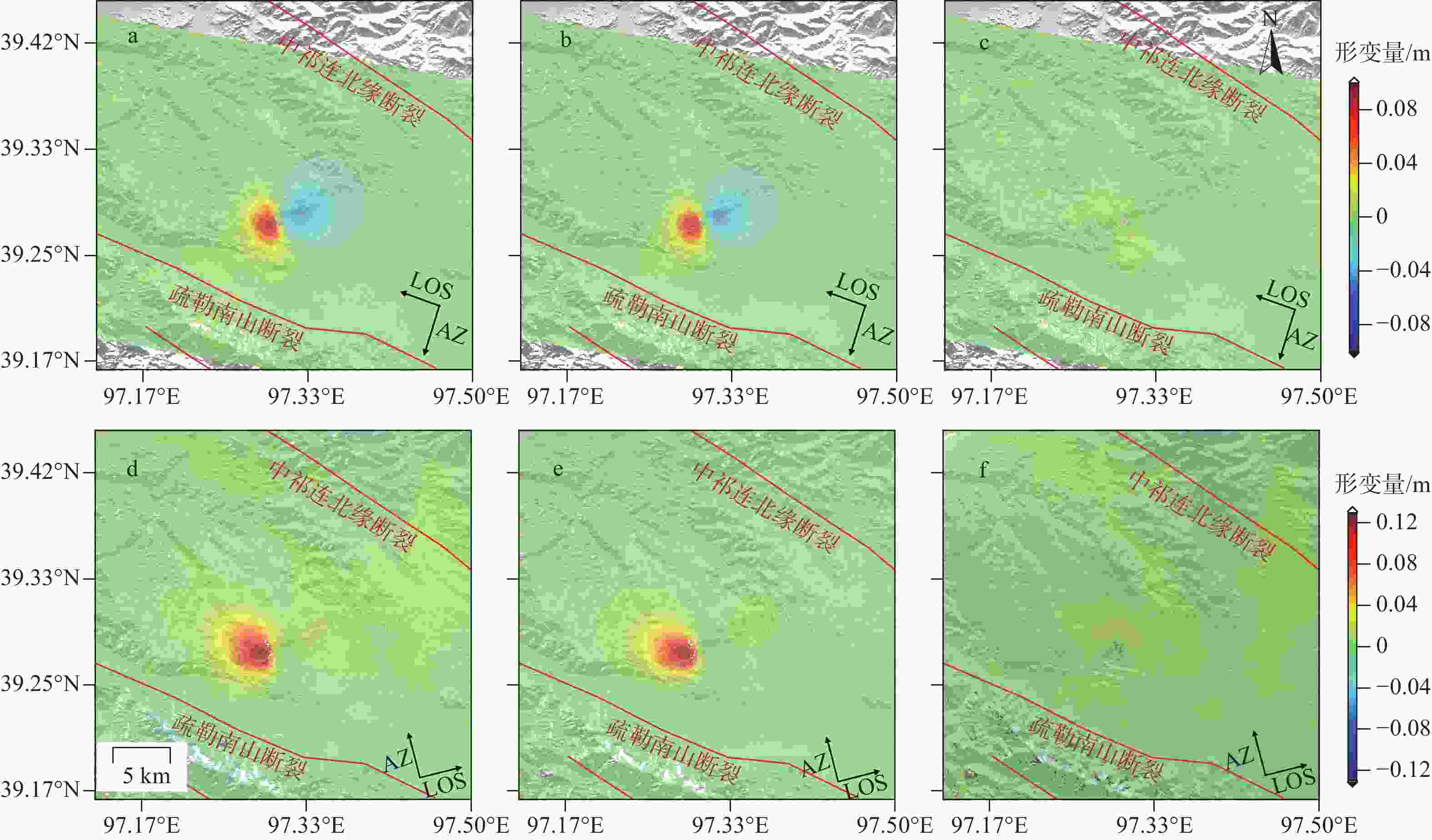
图 3 均匀滑动模型的拟合结果
红色线段表示周边断裂;箭头AZ(Azimuth)表示卫星飞行方向;箭头LOS(Line-of-sight)表示雷达的视线方向a—降轨观测值;b—降轨模拟值;c—降轨残差;d—升轨观测值;e—升轨模拟值;f—升轨残差
Figure 3. Fitting results of the uniform sliding model(a) Descending track observations; (b) Descending track simulations; (c) Descending track residuals; (d) Ascending track observations; (e) Ascending track simulations; (f) Ascending track residuals
The red line segments indicate the surrounding faults, the arrow labeled AZ (Azimuth) shows the satellite flight direction, and the arrow labeled LOS indicates the radar line-of-sight direction.
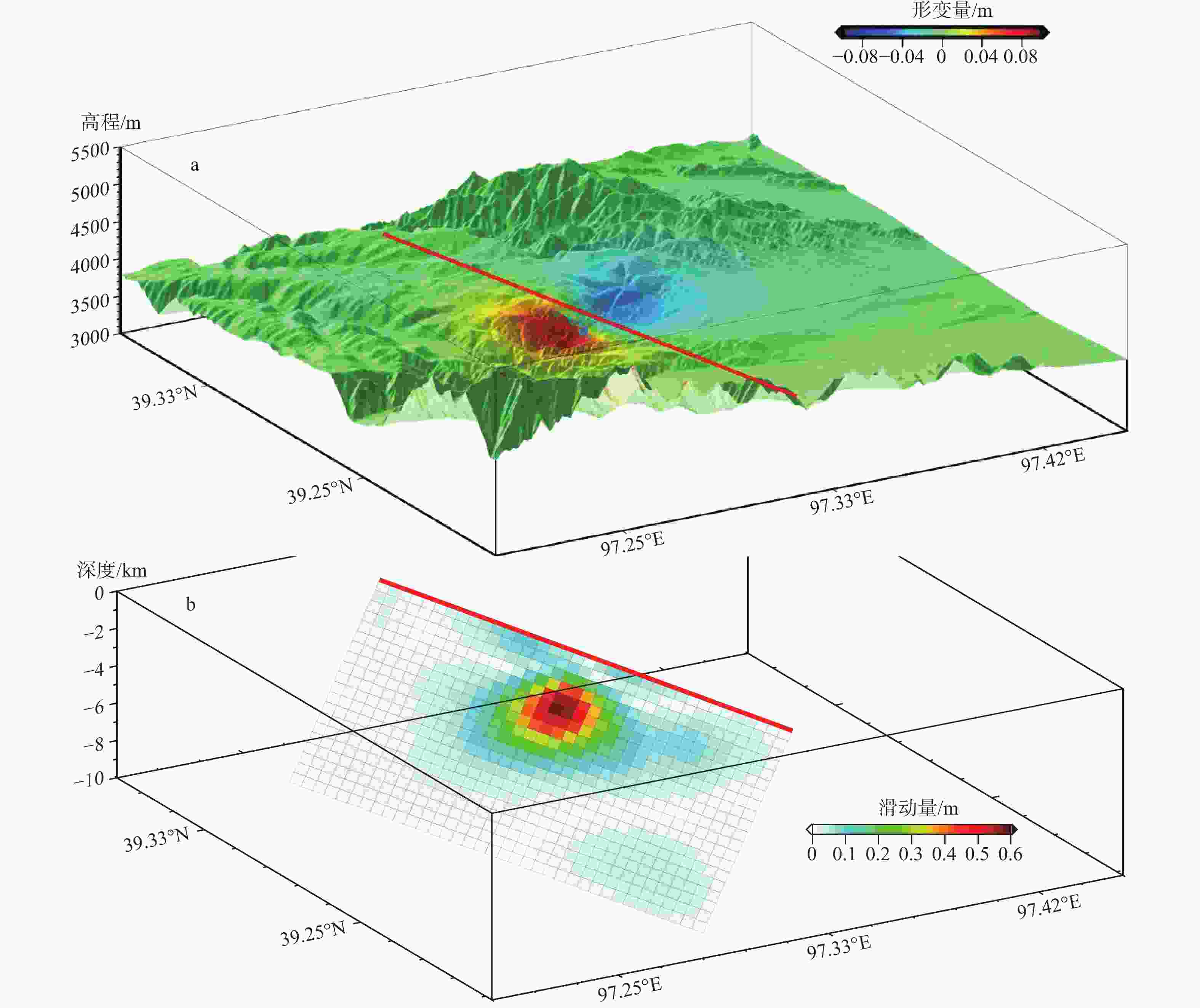
图 4 肃北MS 5.5地震同震滑动分布
红色实线为发震断层在地表的投影a—叠加到区域地形图上的同震形变场;b—三维断层滑动分布
Figure 4. Coseismic slip distribution of the Subei MS 5.5 earthquake(a) Coseismic deformation field superimposed on the regional topographic map; (b) Three-dimensional fault slip distribution
The red solid line represents the surface projection of the seismogenic fault.
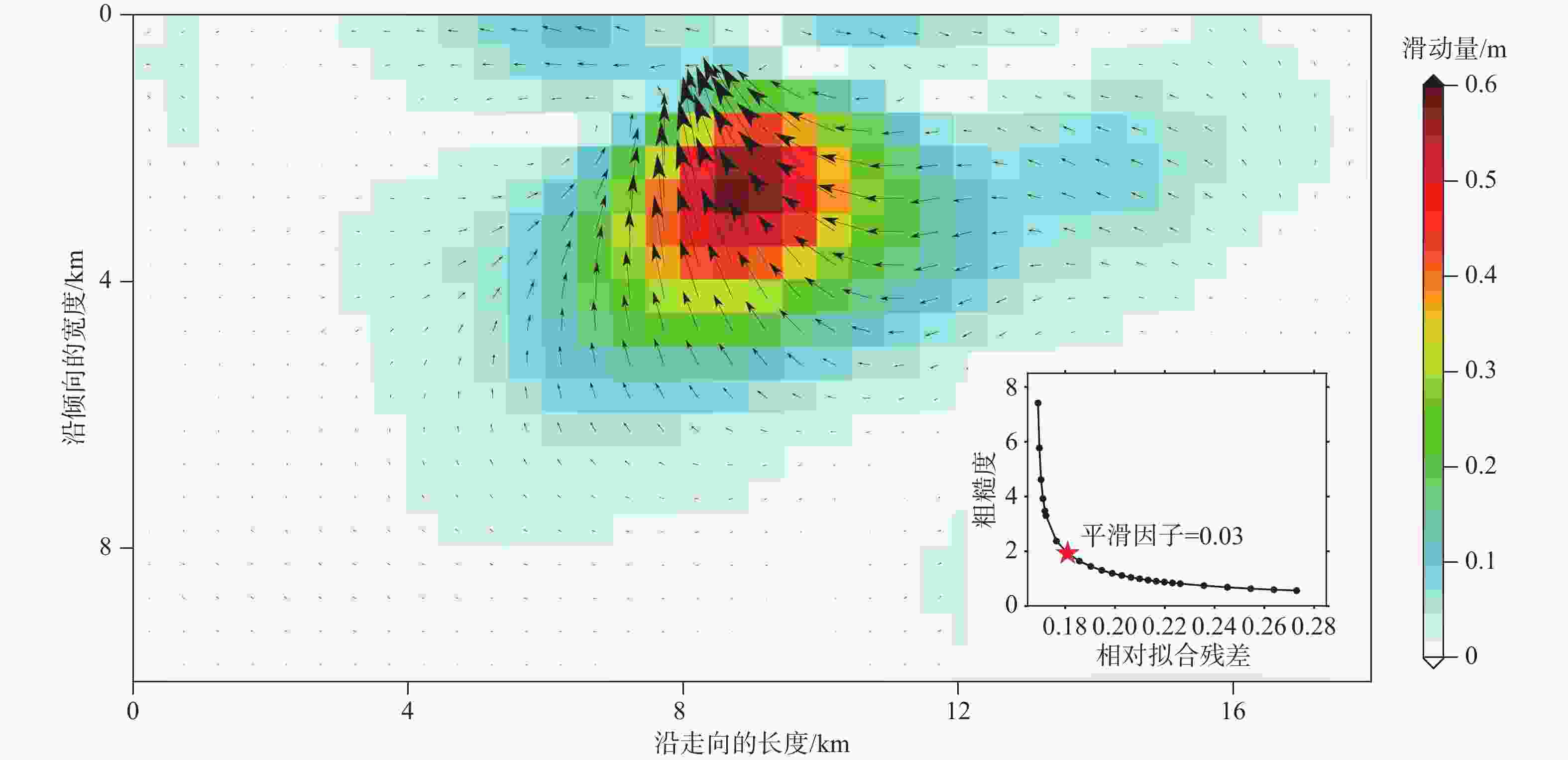
图 5 肃北MS 5.5地震二维同震滑动分布
五角星表示选取平滑因子的位置
Figure 5. Two-dimensional coseismic slip distribution of the Subei MS 5.5 earthquake
The pentagram indicates the location for selecting the smoothing factor.
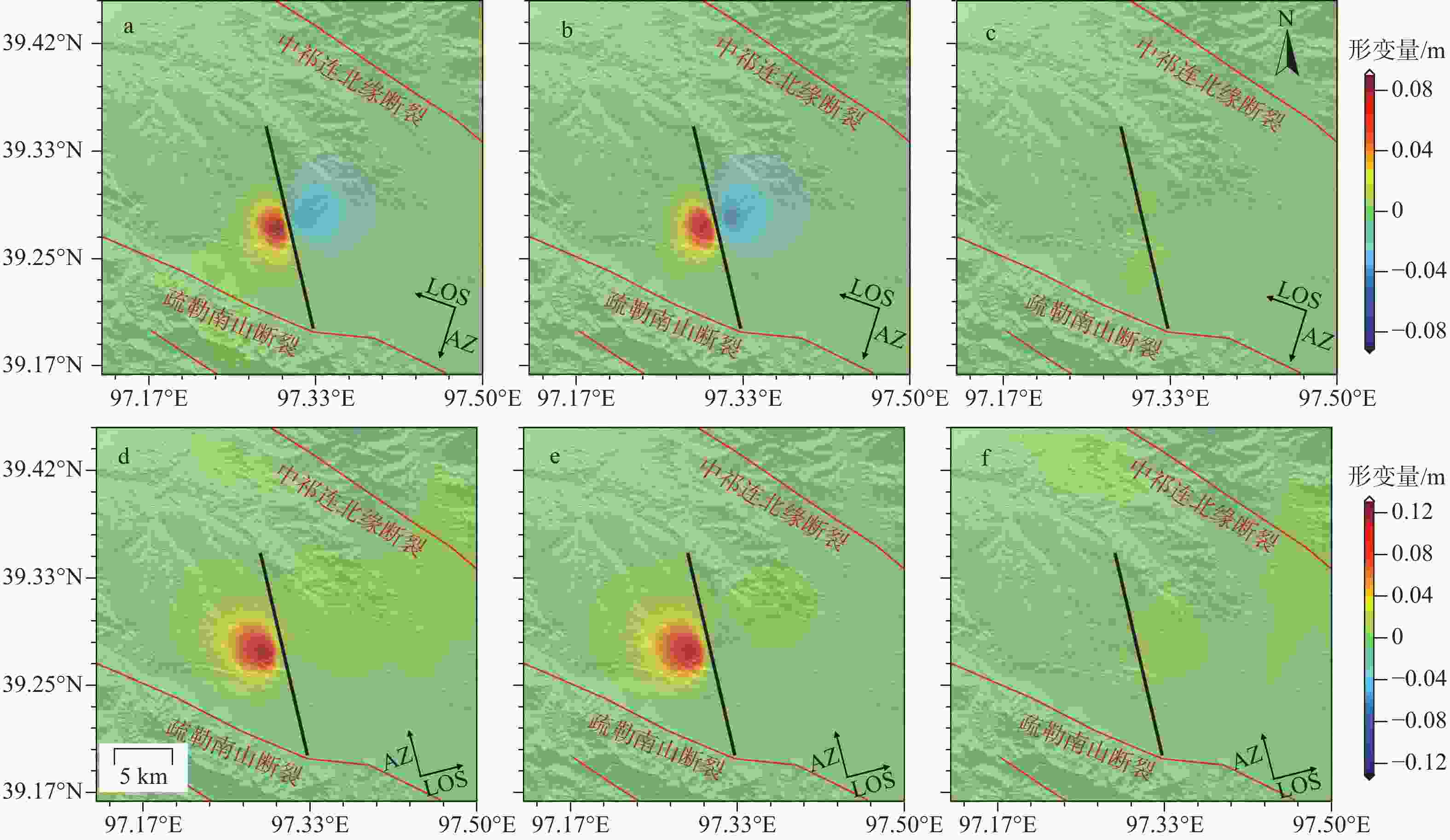
图 6 分布式滑动模型的拟合结果
黑色实线为发震断层在地表的投影;红色线段为周边断裂;箭头AZ(Azimuth)表示卫星飞行方向;箭头LOS(Line-of-sight)表示雷达的视线方向a—降轨观测值;b—降轨模拟值;c—降轨残差;d—升轨观测值;e—升轨模拟值;f—升轨残差
Figure 6. Fitting results of the distributed slip model(a) Descending track observations; (b) Descending track simulations; (c) Descending track residuals; (d) Ascending track observations; (e) Ascending track simulations; (f) Ascending track residuals
The black solid line represents the surface projection of the seismogenic fault, the red line segments indicate the surrounding faults, the arrow labeled AZ (Azimuth) shows the satellite flight direction, and the arrow labeled LOS indicates the radar line-of-sight direction.
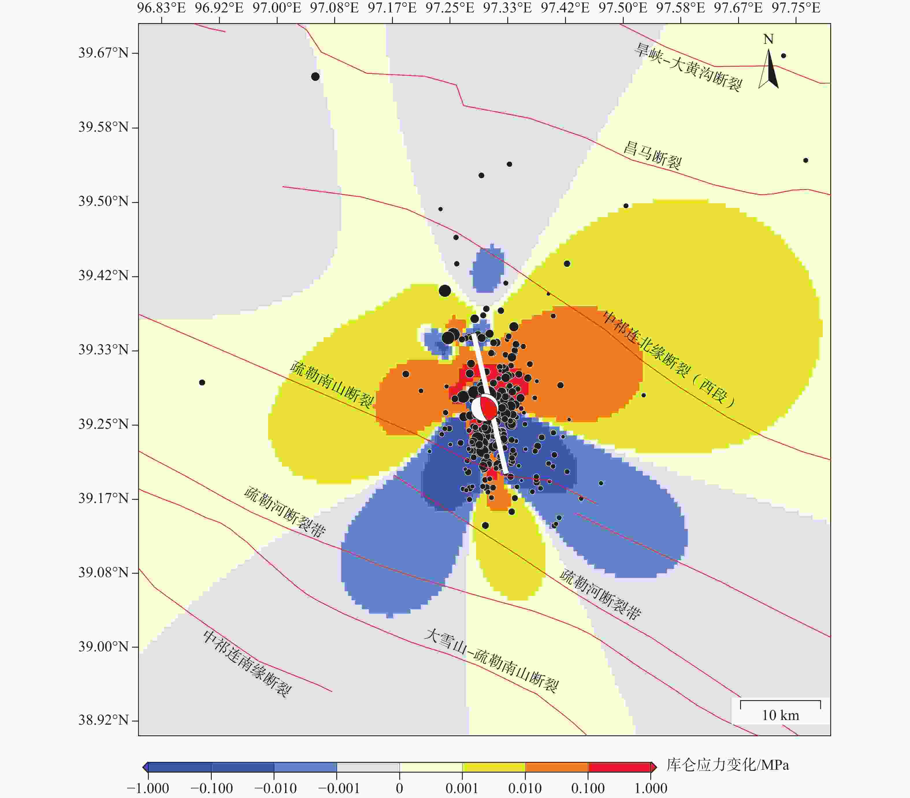
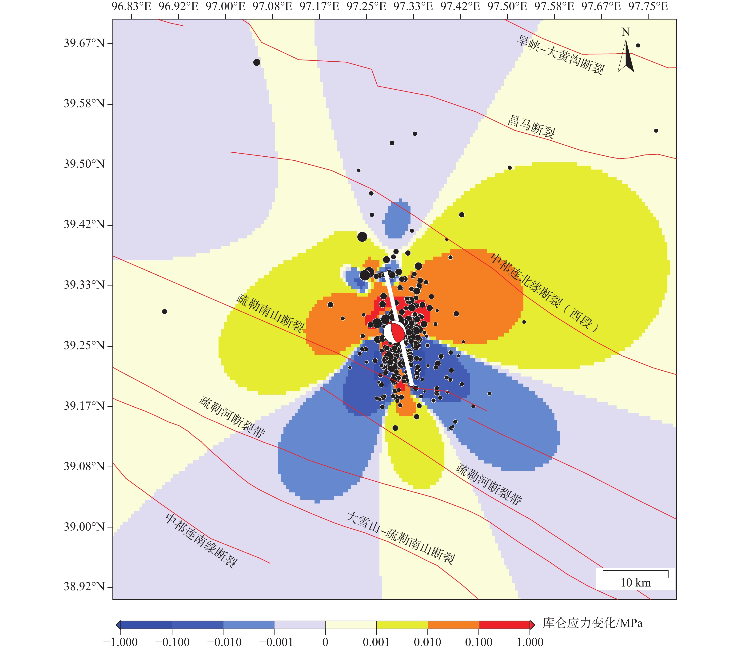
图 7 区域库仑应力变化
白色实线为发震断层在地表的投影;黑色圆圈为2023年10月24日—2023年12月4日期间的小震精定位数据;红色沙滩球为此次肃北MS5.5地震;红色线段为周边断裂
Figure 7. Regional Coulomb stress changes
The white solid line represents the projection of the fault rupture on the ground surface, the black circles indicate the precise locations of small earthquakes from October 24, 2023, to December 4, 2023, the red beach ball represents the focal mechanism solution of the Subei MS 5.5 earthquake, the red line segments indicate the surrounding faults.

图 8 2015—2020年祁连地区周边应变率分布
黑色、蓝色沙滩球分别为逆冲型地震、走滑型历史地震( 2015—2023 年);震源机制解数据( MW≥5.0) 来自哈佛大学全球矩张量解(Global Centroid Moment Tensor,GCMT);红色沙滩球表示此次肃北MS5.5地震;黑色线段为断裂;蓝色线段表示地块边界a—面应变率分布图;b—最大剪应变率分布图
Figure 8. Strain rate distribution around the Qilian region (2015–2020)(a) Distribution of plane strain rate; (b) Distribution of maximum shear strain rate
The black and blue beach balls represent thrust and strike slip historical earthquakes (2015–2023), respectively, with focal mechanism solutions (MW≥5.0) from the Global Centroid Moment Tensor (GCMT) catalog, the red beach ball indicates the focal mechanism of the Subei MS 5.5 earthquake, black line segments represent faults, and the blue line segments indicate tectonic blocks.
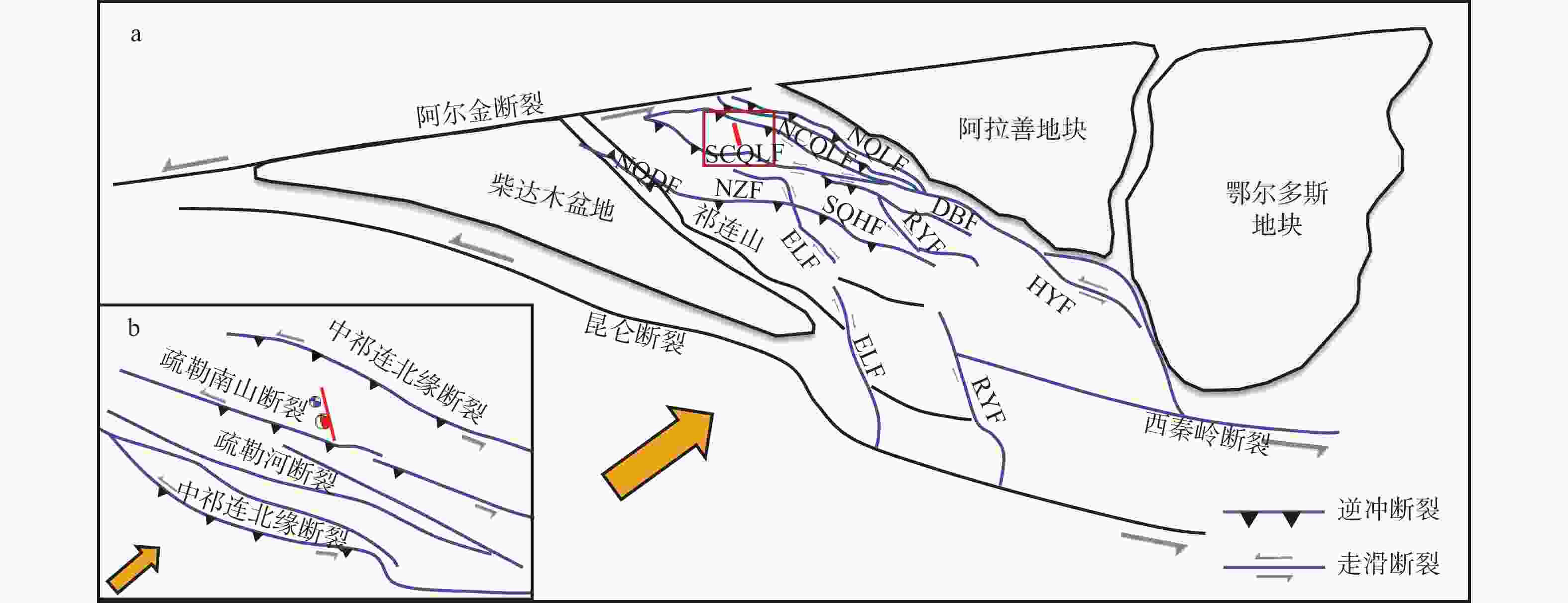
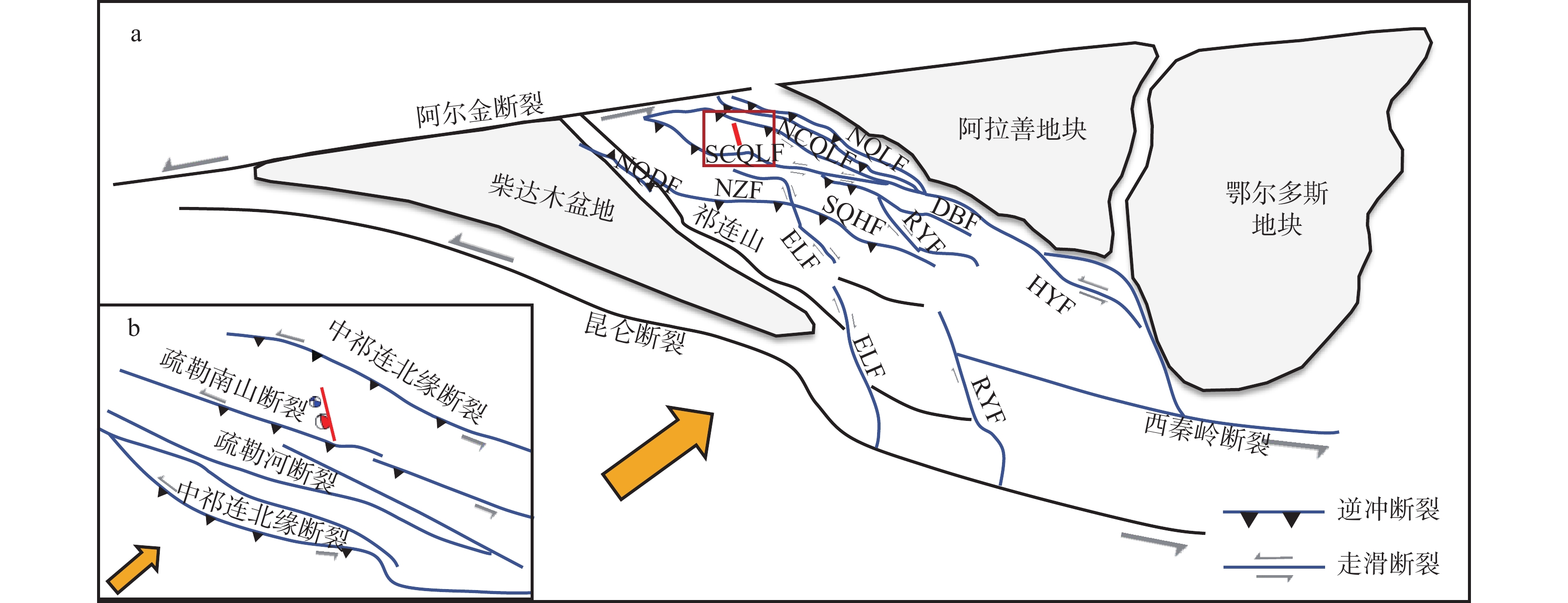
图 9 祁连块体及邻近地区构造活动模式图(据Cheng et al.,2021修改)
NQDF—柴达木盆地北缘断裂;NZF—北宗务隆山断裂;ELF—鄂拉山断裂;SQHF—青海南山断裂;RYF—日月山断裂;SCQLF—中祁连南缘断裂;DBF—达坂山断裂;NCQLF—中祁连北缘断裂;HYF—海原断裂;NQLF—祁连山北缘断裂红色震源机制球为2023年10月24日肃北MS 5.5地震;蓝色震源机制球则表示2023年12月1日的MS 5.0地震;黄色箭头表示青藏高原的北东向运动;红色实线为发震断层在地表的投影;红色矩形框为图9b的范围a—青藏高原东北缘地壳形变模式;b—此次肃北MS 5.5地震的断层形成机制
Figure 9. Tectonic activity pattern of the Qilian Block and adjacent regions (modified after Cheng et al., 2021)
(a) Crustal deformation pattern of the northeastern margin of the Qinghai-Tibet Plateau; (b) Fault formation mechanism of the 2023 Subei MS 5.5 Earthquake The red focal mechanism beach ball indicates the MS 5.5 earthquake on October 24, 2023, the blue focal mechanism beach ball indicates the MS 5.0 earthquake on December 1, 2023, the yellow arrow indicates the north-eastward movement of the Qinghai-Tibet Plateau, the red solid line is the projection of the seismogenic fault onto the ground surface, and the red rectangle indicates the area of Figure 9b.
表 1 SAR干涉图信息表
Table 1. Parameters of SAR interferograms
地震时间 轨道方向 轨道号 入射角/(°) 方位角/(°) 影像日期 垂直基线/m 时间基线/d 震前 震后 2023-10-24 降轨 4 39° −170° 2023-10-18 2023-10-30 24 12 升轨 99 38° −10° 2023-09-19 2023-12-12 90 84 2023-12-01 降轨 4 39° −170° 2023-11-23 2023-12-05 88 12  下载: 导出CSV
表 2 2023年肃北MS 5.5地震的震源机制解
Table 2. Focal mechanism solutions of the Subei Earthquake
机构来源 震中位置 震级 深度/km 节面1/(°) 节面2/(°) 北纬/(°) 东经/(°) 走向角 倾角 滑动角 走向角 倾角 滑动角 USGS 39.279 97.302 5.43 13.5 309 53 64 168 44 120 CENC 39.43 97.28 5.5 10 — — — — — — GFZ 39.24 97.42 5.4 19 152 39 91 330 50 88 IPGP 39.265 97.308 5.3 12 306 45 49 177 58 123 CEA-IGP 39.43 97.28 5.4 5 170 60 110 313 35 59 张潇等,2024 39.43 97.28 5.5 4 170 73 108 300 24 42 注 USGS 美国地质调查局( https://earthquake.usgs.gov/earthquakes );CENC中国地震台网中心(http://www.csi.ac.cn/ );GFZ德国地学中心(https://geofon.gfz-potsdam.de/ );IPGP法国巴黎地球物理研究中心(http://geoscope.ipgp.fr/index.php/en/catalog );CEA-IGP中国地震局地球物理研究所(https://www.cea-igp.ac.cn/kydt/280278.html )
下载: 导出CSV
表 3 肃北MS 5.5地震GBIS反演参数
Table 3. GBIS inversion parameters for the Subei MS 5.5 Earthquake
参数 长度/m 宽度/m 深度/m 走向角/(°) 倾角/(°) 走滑/m 倾滑/m X/m Y/m 肃北地震 1260 3568 4723 166.97 68.69 −0.72 0.99 −1810 −761
下载: 导出CSV
-
[1] BAGNARDI M, HOOPER A, 2018. Inversion of surface deformation data for rapid estimates of source parameters and uncertainties: a Bayesian approach[J]. Geochemistry, Geophysics, Geosystems, 19(7): 2194-2211. [2] CHEN H Y, ZHAO C Y, LI B, et al., 2023. Monitoring spatiotemporal evolution of Kaiyang landslides induced by phosphate mining using distributed scatterers InSAR technique[J]. Landslides, 20(3): 695-706. doi: 10.1007/s10346-022-01986-5 [3] CHEN X H, SHAO Z G, XIONG X S, et al., 2019. Fault system, deep structure and tectonic evolution of the Qilian Orogenic Belt, Northwest China[J]. Geology in China, 46(5): 995-1020. (in Chinese with English abstract [4] CHENG F, ZUZA A V, HAPROFF P J, et al., 2021. Accommodation of India–Asia convergence via strike-slip faulting and block rotation in the Qilian Shan fold–thrust belt, northern margin of the Tibetan Plateau[J]. Journal of the Geological Society, 178(3): jgs2020-207. [5] CHENG J W, CHEN J F, LIU X Z, 2020. Division of seismic statistical areas and analysis of seismicity trend in the northern part of the Qinghai-Tibet Plateau[J]. Seismological and Geomagnetic Observation and Research, 41(3): 1-11. (in Chinese with English abstract [6] CHU Y B, 2015. The geomorphy characteristic of Qilian Mountains and its response to Tibetan Plateau uplift[D]. Chengdu: Chengdu University of Technology. (in Chinese) [7] FIALKO Y, 2006. Interseismic strain accumulation and the earthquake potential on the southern San Andreas fault system[J]. Nature, 441(7096): 968-971. [8] GABRIEL A K, GOLDSTEIN R M, ZEBKER H A, 1989. Mapping small elevation changes over large areas: differential radar interferometry[J]. Journal of Geophysical Research: Solid Earth, 94(B7): 9183-9191. [9] GAN W J, ZHANG P Z, SHEN Z K, et al., 2007. Present-day crustal motion within the Tibetan Plateau inferred from GPS measurements[J]. Journal of Geophysical Research: Solid Earth, 112(B8): B08416. [10] GUO F, WANG Y, XIE M Y, et al., 2023. Summary of the Sunan MS 5.1 earthquake in Gansu on March 17, 2022[J]. Seismological and Geomagnetic Observation and Research, 44(2): 1-10. (in Chinese with English abstract [11] GUO P, HAN Z J, GAO F, et al., 2020. A new tectonic model for the 1927 M8.0 Gulang earthquake on the NE Tibetan Plateau[J]. Tectonics, 39(9): e2020TC006064. [12] HAO M, WANG Q L, SHEN Z K, et al., 2014. Present day crustal vertical movement inferred from precise leveling data in eastern margin of Tibetan Plateau[J]. Tectonophysics, 632: 281-292. [13] JI L Y, LIU C J, XU J, et al., 2017. InSAR observation and inversion of the seismogenic fault for the 2017 Jiuzhaigou MS7.0 earthquake in China[J]. Chinese Journal of Geophysics, 60(10): 4069-4082. (in Chinese with English abstract [14] JI L Y, XU J D, LIU L, et al., 2021. A review of present-day deformation of active volcanoes in China between 1970 and 2013[J]. Geological Society, London, Special Publications, 510: 215-226. [15] LI H Y, SHEN Y, HUANG Z X, et al., 2014. The distribution of the mid-to-lower crustal low-velocity zone beneath the northeastern Tibetan Plateau revealed from ambient noise tomography[J]. Journal of Geophysical Research: Solid Earth, 119(3): 1954-1970. [16] LI S Y, 2023. Combining GNSS and seismic anisotropy data to constrain upper crustal deformation in the northeastern Tibetan Plateau[D]. Beijing: Institute of Earthquake Forecasting, CEA. (in Chinese with English abstract [17] LI W, HE X H, ZHANG Y P, et al., 2023. The 2022 Delingha, China, earthquake sequence and implication for seismic hazard near the western end of the Qilian–Haiyuan fault[J]. Seismological Research Letters, 94(4): 1733-1746. [18] LIU C J, JI L Y, ZHU L Y, et al., 2024. Kilometer-resolution three-dimensional crustal deformation of Tibetan Plateau from InSAR and GNSS[J]. Science China Earth Sciences, 67(6): 1818-1835. [19] LIU X H, YAO X, YANG B, et al., 2023. InSAR-based indentification and spatial distribution analysis of active landslides in the Western Sichuan Plateau[J]. Journal of Geomechanics, 29(1): 111-126. (in Chinese with English abstract [20] LUO H, XU X W, LIU X L, et al., 2020. The structural deformation pattern in the eastern segment of the Altyn Tagh fault[J]. Acta Geologica Sinica, 94(3): 692-706. (in Chinese with English abstract [21] SHAO Y X, YUAN D Y, LEI Z S, et al., 2011. The features of earthquake surface rupture zone on northern margin fault of Danghe Nanshan[J]. Technology for Earthquake Disaster Prevention, 6(4): 427-435. (in Chinese with English abstract [22] TANG D W, GE W P, YUAN D Y, et al., 2023. Triggering effect of historical earthquakes in the northern Tibetan Plateau on the Coulomb stress of the 2022 Menyua MS6.9 earthquake and subsequent earthquakes[J]. Chinese Journal of Geophysics, 66(7): 2772-2795. (in Chinese with English abstract [23] TU H W, WANG R J, DIAO F Q, et al., 2016. Slip model of the 2001 Kunlun mountain MS8.1 earthquake by SDM: joint inversion from GPS and InSAR data[J]. Chinese Journal of Geophysics, 59(4): 404-413. doi: 10.1002/cjg2.20245 [24] VAN DER WOERD J, XU X W, LI H B, et al., 2001. Rapid active thrusting along the northwestern range front of the Tanghe Nan Shan (western Gansu, China)[J]. Journal of Geophysical Research: Solid Earth, 106(B12): 30475-30504. [25] WAN Y G, SHEN Z K, ZENG Y H, et al., 2007. Evolution of cumulative Coulomb failure stress in northeastern Qinghai-Xizang (Tibetan) Plateau and its effect on large earthquake occurrence[J]. Acta Seismologica Sinica, 29(2): 115-129. (in Chinese with English abstract [26] WANG H, ZHANG G M, WU Y, et al., 2003. The deformation of active crustal-blocks on the Chinese Mainland and its relation with seismic activity[J]. Earthquake research in China, 19(3): 243-254. (in Chinese with English abstract [27] WANG J S, ZHAO N Y, 2020. Seismogenic structure of 2018 Xietongmen, Tibet MW5.6 earthquake inferred from InSAR data[J]. China Earthquake Engineering Journal, 42(2): 384-390. (in Chinese with English abstract [28] WANG R J, MARTÍN F L, ROTH F, 2003. Computation of deformation induced by earthquakes in a multi-layered elastic crust—FORTRAN programs EDGRN/EDCMP[J]. Computers & Geosciences, 29(2): 195-207. [29] WANG R J, LORENZO-MARTÍN F, ROTH F, 2006. PSGRN/PSCMP—a new code for calculating co- and post-seismic deformation, geoid and gravity changes based on the viscoelastic-gravitational dislocation theory[J]. Computers & Geosciences, 32(4): 527-541. [30] WU X Y, XU X W, YU G H, et al., 2024. The China Active Faults Database (CAFD) and its web system[J]. Earth System Science Data, 16(7): 3391-3417. [31] WU Z H, 2024. The earthquake-controlling process of continental collision-extrusion active tectonic system around the Qinghai-Tibet Plateau: a case study of strong earthquakes since 1990[J]. Journal of Geomechanics, 30(2): 189-205. (in Chinese with English abstract [32] XIONG G H, JI L Y, LIU C J, 2023. Analysing the surface deformation and present-day magma activity of Changbaishan-Tianchi volcano from 2015 to 2022 with InSAR technology[J]. Seismology and Geology, 45(6): 1309-1327. (in Chinese with English abstract [33] XIONG W, XU C J, CHEN W, et al., 2024. The 2022 Har Lake earthquake sequence highlights a complex fault system in the western Qilian Shan, northeastern Tibetan Plateau[J]. Geophysical Journal International, 238(2): 1089-1102. [34] XU H, SHU B, ZHANG Q, et al., 2024. Site selection for landslide GNSS monitoring stations using InSAR and UAV photogrammetry with analytical hierarchy process[J]. Landslides, 21(4): 791-805. [35] YANG X P, CHEN J, LI A, et al., 2024. Structural deformation characteristics of active anticline and their implications for seismogeological disaster effect under compression setting in the Late Cenozoic[J]. Journal of Geomechanics, 30(2): 225-241. (in Chinese with English abstract [36] YU C, LI Z H, PENNA N T, 2018. Interferometric synthetic aperture radar atmospheric correction using a GPS-based iterative tropospheric decomposition model[J]. Remote Sensing of Environment, 204: 109-121. [37] YUE H, ZHANG Y, GE Z X, et al., 2020. Resolving rupture processes of great earthquakes: reviews and perspective from fast response to joint inversion[J]. Science China Earth Sciences, 63(4): 492-511. [38] ZHANG B, XU G C, LU Z P, et al., 2021. Coseismic deformation mechanisms of the 2021 MS 6.4 Yangbi earthquake, Yunnan Province, using InSAR observations[J]. Remote Sensing, 13(19): 3961. [39] ZHANG N, XU W J, WANG J, et al., 2020. Study on the zonal dynamic characteristics of strain rate field in the north section of the North-South Seismic Belt[J]. Progress in Geophysics, 35(5): 1724-1735. (in Chinese) [40] ZHANG P Z, SHEN Z K, WANG M, et al., 2004. Continuous deformation of the Tibetan Plateau from global positioning system data[J]. Geology, 32(9): 809-812. [41] ZHANG W T, JI L Y, ZHU L Y, et al., 2022. Current slip and strain rate distribution along the Ganzi-Yushu-Xianshuihe fault system based on InSAR and GPS observations[J]. Frontiers in Earth Science, 10: 821761. [42] ZHANG X, LI Z Y, GUO X Y, et al., 2024. The focal mechanism solution and seismogenic structure of the Subei MS5.5 earthquake in Gansu on October 24th, 2023[J]. North China Earthquake Sciences, 42(2): 51-58. (in Chinese with English abstract [43] ZHAO L B, ZHAO L F, XIE X B, et al., 2016. Static Coulomb stress changes and seismicity rate in the source region of the 12 February, 2014 MW7.0 Yutian earthquake in Xinjiang, China[J]. Chinese Journal of Geophysics, 59(10): 3732-3743. (in Chinese with English abstract [44] ZHAO N Y, JI L Y, ZHANG W T, et al., 2023. Present-day kinematics and seismic potential of the Ganzi-Yushu fault, eastern Tibetan Plateau, constrained from InSAR[J]. Frontiers in Earth Science, 11: 1123711. [45] ZHENG W J, 2009. Geometric pattern and active tectonics of the Hexi Corridor and its adjacent regions[D]. Beijing: Institute of Geology, China Earthquake Administrator, 1-181. (in Chinese with English abstract [46] ZHU L, DAI Y, SHI F Q, et al., 2022. Coulomb stress evolution and seismic hazards along the Qilian-Haiyuan fault zone[J]. Acta Seismologica Sinica, 44(2): 223-236. (in Chinese with English abstract [47] ZIV A, RUBIN A M, 2000. Static stress transfer and earthquake triggering: no lower threshold in sight?[J]. Journal of Geophysical Research: Solid Earth, 105(B6): 13631-13642. [48] ZOU X B, LI X J, SHAO Y X, et al., 2024. Tectonic deformation and seismic mechanism of the 2021 Aksai MS5.5 earthquake[J]. Journal of Geomechanics, 30(6): 978-990. (in Chinese with English abstract [49] 陈宣华,邵兆刚,熊小松,等,2019. 祁连造山带断裂构造体系、深部结构与构造演化[J]. 中国地质,46(5):995-1020. [50] 程建武,陈继峰,刘旭宙,2020. 青藏高原北部地区地震统计区划分及地震活动特征[J]. 地震地磁观测与研究,41(3):1-11. [51] 褚永彬,2015. 祁连山地貌特征及对青藏高原隆升的响应[D]. 成都:成都理工大学. [52] 郭菲,王月,解孟雨,等,2023. 2022年3月17日甘肃肃南MS5.1地震总结[J]. 地震地磁观测与研究,44(2):1-10. [53] 季灵运,刘传金,徐晶,等,2017. 九寨沟MS7.0地震的InSAR观测及发震构造分析[J]. 地球物理学报,60(10):4069-4082. [54] 李抒予,2023. GNSS与地震各向异性资料联合约束青藏高原东北部上地壳变形[D]. 北京:中国地震局地震预测研究所. [55] 刘传金,季灵运,朱良玉,等,2024. 联合InSAR和GNSS构建青藏高原千米分辨率三维地壳形变场[J]. 中国科学:地球科学,54(6):1845-1862. [56] 刘星洪,姚鑫,杨波,等,2023. 川西高原活动性滑坡识别与空间分布特征研究[J]. 地质力学学报,29(1):111-126. [57] 罗浩,徐锡伟,刘小利,等,2020. 阿尔金断裂东段的构造转换模式[J]. 地质学报,94(3):692-706. doi: 10.3969/j.issn.0001-5717.2020.03.002 [58] 邵延秀,袁道阳,雷中生,等,2011. 党河南山北缘断裂古地震形变带特征研究[J]. 震灾防御技术,6(4):427-435. doi: 10.11899/zzfy20110408 [59] 汤大委,葛伟鹏,袁道阳,等,2023. 青藏高原北部历史强震对2022年门源MS6.9地震及后续地震库仑应力触发作用[J]. 地球物理学报,66(7):2772-2795. [60] 万永革,沈正康,曾跃华,等,2007. 青藏高原东北部的库仑应力积累演化对大地震发生的影响[J]. 地震学报,29(2):115-129. [61] 王辉,张国民,吴云,等,2003. 中国大陆活动地块变形与地震活动的关系[J]. 中国地震,19(3):243-254. [62] 王金烁,赵宁远,2020. 利用InSAR技术研究2018年西藏谢通门MW5.6地震发震构造[J]. 地震工程学报,42(2):384-390. [63] 吴中海,2024. 青藏高原陆陆碰撞-挤出活动构造体系控震作用:以1990年以来强震活动为例[J]. 地质力学学报,30(2):189-205. doi: 10.12090/j.issn.1006-6616.2023186 [64] 熊国华,季灵运,刘传金,2023. 长白山天池火山2015—2022年InSAR变形与活动状态分析[J]. 地震地质,45(6):1309-1327. doi: 10.3969/j.issn.0253-4967.2023.06.004 [65] 杨晓平,陈杰,李安,等,2024. 新生代晚期挤压作用下活动背斜区的构造变形特征及其地震地质灾害效应[J]. 地质力学学报,30(2):225-241. doi: 10.12090/j.issn.1006-6616.2023136 [66] 岳汉,张勇,盖增喜,等,2020. 大地震震源破裂模型:从快速响应到联合反演的技术进展及展望[J]. 中国科学:地球科学,50(4):515-537. [67] 张楠,许文俊,王静,等,2020. 南北地震带北段分区应变率场动态变化特征研究[J]. 地球物理学进展,35(5):1724-1735. doi: 10.6038/pg2020DD0465 [68] 张潇,李振月,郭祥云,等,2024. 2023年10月24日甘肃肃北MS5.5地震震源机制及发震构造[J]. 华北地震科学,42(2):51-58. [69] 赵立波,赵连锋,谢小碧,等,2016. 2014年2月12日新疆于田MW7.0地震源区静态库仑应力变化和地震活动率[J]. 地球物理学报,59(10):3732-3743. doi: 10.6038/cjg20161018 [70] 郑文俊,2009. 河西走廊及其邻区活动构造图像及构造变形模式[D]. 北京:中国地震局地质研究所,1-181. [71] 朱琳,戴勇,石富强,等,2022. 祁连—海原断裂带库仑应力演化及地震危险性[J]. 地震学报,44(2):223-236. doi: 10.11939/jass.20220012 [72] 邹小波,李兴坚,邵延秀,等,2024. 2021年阿克塞MS5.5地震区形变特征及发震机制研究[J]. 地质力学学报,30(6):978-990. doi: 10.12090/j.issn.1006-6616.2023125 -

 下载:
下载:


计量
- 文章访问数: 2068
- HTML全文浏览量: 381
- PDF下载量: 49
- 被引次数: 0
