

Characteristics of geological hazard development and disaster-inducing environment of the MS6.2 earthquake in Jishishan, Gansu Province
-
摘要: 2023年12月18日甘肃省临夏州积石山县发生MS 6.2地震,此次地震诱发了崩塌、滑坡和泥流等一系列地质次生灾害,是近年来中国6级以上地震损失极其严重的一次。综合分析区域孕灾环境及地质次生灾害发育特征发现,拉脊山地区海拔高、地形复杂、活断裂作用显著以及第四纪松散堆积物覆盖广且厚度大等因素,使得该地区在地震作用下极易产生蠕滑−拉裂破坏并诱发滑坡等地质次生灾害。利用层次分析法综合考虑断裂、地层岩性、植被覆盖、坡度及降水5个关键因子对积石山区域地质灾害发育的影响。研究结果显示,地层岩性是区域地质次生灾害的主导因素,其权重可达42%;其次是断层,权重约占26%;而降水的影响权重虽然只占6%,但也不可忽视。积石山及其邻区地质次生灾害危险区主要集中在震中周围的拉脊山前缘一带,呈条状分布,与VIII度地震烈度区域大体一致。地质次生灾害点受软弱地质环境影响为主,集中在拉脊山断裂带下盘,尤其是积石山县、大家河镇和白藏镇等地,灾害分布密集且受地震影响显著,需要重点监测及预防,同时对第四系黄土层防护工程也应予以足够重视。另一方面,在余震分布密集区,未发现显著的地质次生灾害点,推测是因为主震释放了较大应力,诱发了主要地质次生灾害。在多次余震之后,岩体应力状态逐渐趋于平衡,地质构造在震后重组并趋向稳定,从而降低了进一步发生地质次生灾害的风险。Abstract:
Objective The MS6.2 earthquake that struck Jishishan County, Gansu Province, on December 18, 2023, triggered a series of secondary geological disasters, including landslides, collapses, and debris flows. This earthquake is considered one of the most devastating seismic events in China in recent years. The study aims to analyze the characteristics of seismicity-induced disasters in the region and identify the underlying geological factors contributing to these secondary geological hazards. Specifically, the research focuses on how the geological environment influences the development of these disasters, particularly landslides, collapses, and debris flows. This understanding will help to develop better disaster prevention and mitigation strategies for similar seismic regions. Methods To investigate these issues, the study uses a combination of field investigations, remote sensing image interpretation, and the analytic hierarchy process (AHP). The AHP was employed to evaluate the relative importance of five key factors—faults, lithology, vegetation cover, slope, and precipitation—in the formation of secondary geological hazards. The analysis also includes a detailed spatial distribution study of these factors and how they interact under seismic conditions. This multi-method approach provides a comprehensive understanding of the complex geological environment in Jishishan. Results Based on the integrated analysis, the secondary geological hazard zones of the study area are primarily concentrated along the front edge of Lajishan, closely aligned with the VIII seismic intensity zone of the Jishishan MS6.2 earthquake. Fewer hazard zones are located at the northern edge of Lijia Village, Guantan Village, and Manisigou Township. The higher-risk areas are centered around Jishishan County, extending eastward toward Lijia Village and Hanji Town. The secondary geological disaster points are concentrated in Jishishan County and the area surrounding it, particularly in valleys where Quaternary strata are abundant, forming a band-like distribution. Landslides are most prevalent in Jishishan County and Dahejia Town, where steep terrain, fragile geological structure, and significant rock weathering make the area vulnerable. The lack of vegetation exacerbates surface instability. Debris flows mainly occur in Baizang Town and around Jishishan, where steep slopes, concentrated rainfall, and abundant loose materials create ideal conditions for disaster. These debris flow sites are located near rivers or lakes, indicating that water flow and increased soil saturation are key factors triggering such events. Landslide sites are generally scattered but concentrated in areas of significant topographic change, following the Quaternary strata in valleys. These sites are denser near the Lajishan fault zone, showing the influence of fault proximity and rainfall on landslide occurrence. Each type of geological disaster exhibits distinct spatial patterns: landslides and debris flows are more likely to occur in areas with steep slopes and proximity to water bodies, while collapses tend to occur in exposed rock areas, influenced by local lithology. Evidently, the distribution of secondary geological hazards in the study area is primarily influenced by weak geological conditions, with seismic activity, vegetation, topography, and precipitation compounding the risk. Hazard zones are concentrated along the front of Lajishan, matching the VIII seismic intensity zone. The disaster sites are primarily located in valleys with dense fourth-level strata, confirming the consistency between the simulated and actual hazard zones. Conclusion To conclude, lithology was found to be the most significant factor influencing disaster formation, with a weight of 42%, followed by fault zones (26%). While precipitation had the least impact, contributing only 6%, it still played a role in increasing the risk of landslides and debris flows. The high-risk disaster areas correspond closely to the seismic intensity zone VIII, particularly around the earthquake epicenter, where the geological conditions are most conducive to these hazards. The distribution of secondary geological disasters in Jishishan is primarily controlled by the weak geological conditions of the region. Besides, compared to the Wenchuan earthquake, where disasters were concentrated along the hanging wall of reverse faults, the disaster sites in Jishishan were mainly located in the down-thrust areas of fault zones. Additionally, fewer disaster points were observed in aftershock zones, suggesting that the main shock alleviated a significant amount of tectonic stress, leading to regional stabilization. [ Significance ] This study highlights the relationship between geological factors and seismicity-induced secondary disasters in Jishishan, emphasizing the need for targeted monitoring and protective measures in areas with loose Quaternary deposits and steep slopes. The results provide valuable insight for disaster prevention strategies in Jishishan and other seismic regions with similar geological conditions. -
Key words:
- Jishishan earthquake /
- disaster-prone environment /
- landslide /
- mudflow /
- spatial analysis
-
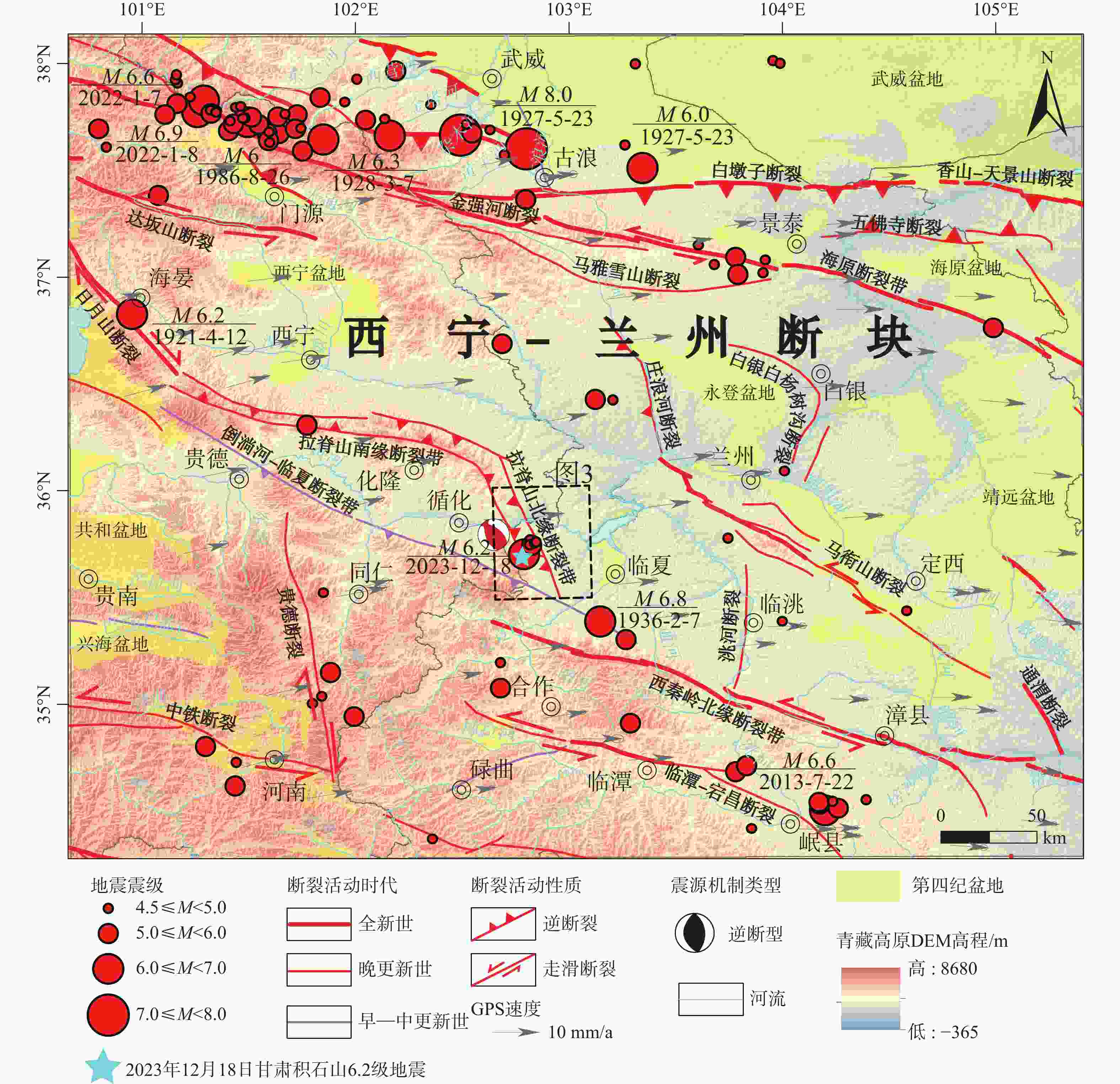
图 1 区域构造地质图(据陆诗铭等,2024修改)
其中活动断裂相关数据源自郑文俊等,2019与袁道阳等,2004a;地震数据与震源机制解数源自USGS;GPS数据源自Wang, et al.,2020
Figure 1. Regional tectono-geological map (modified after Lu et al., 2024)
The active fault data are from Zhen et al.,2019 and Yuan et al., 2004a. The earthquake data and focal mechanism solutions are from the USGS, and the GPS data are from Wang et al., 2020.
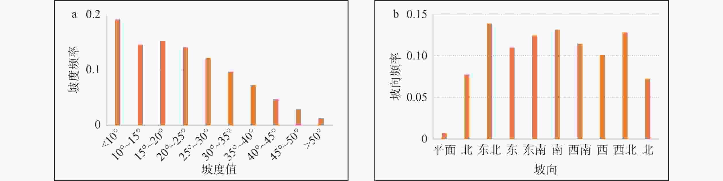
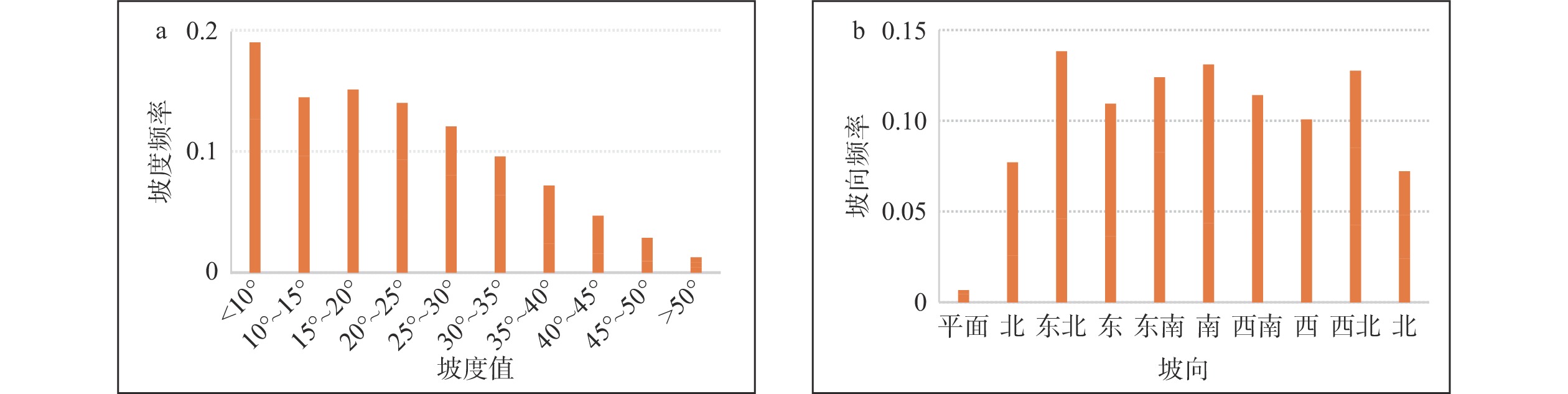
图 2 拉脊山−积石山地区坡度、坡向统计图
a—拉脊山−积石山地区坡度−坡度频率图 ;b—拉脊山−积石山地区坡向−坡向频率图
Figure 2. Gradient and slope orientation statistics for the Lajishan-Jishishan area
(a) Gradient frequency in the Lajishan-Jishishan area; (b) Slope direction frequency in the Lajishan-Jishishan area
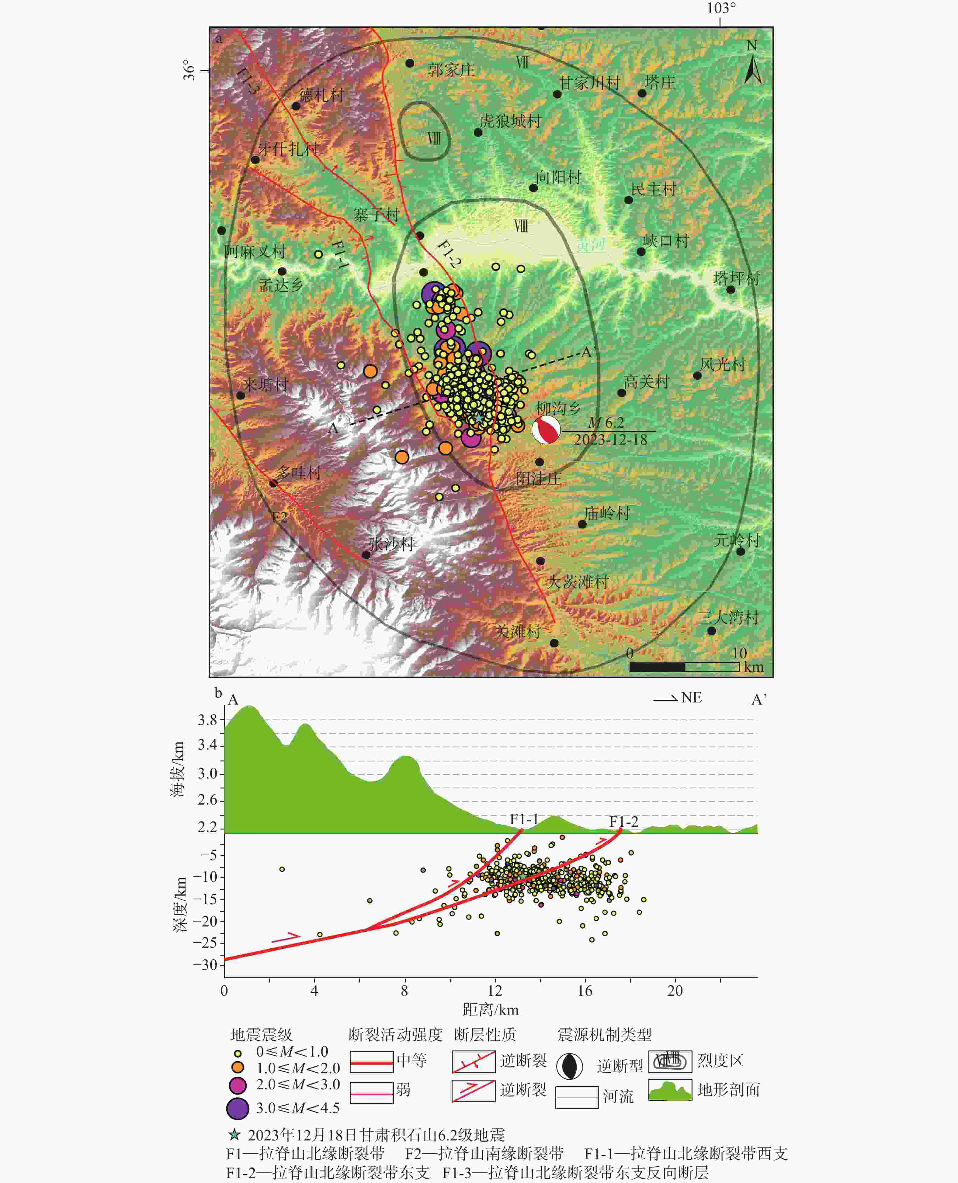
图 3 区域地震构造图及余震分布剖面图(据陆诗铭等,2024修改)
其中地震烈度数据源自应急管理部中国地震局(
https://www.mem.gov.cn/ );余震数据源自郭祥云等,2024;断层活动强度数据源自吴中海和周春景,2018a—区域地震地质构造图;b—区域地形剖面图及余震分布图Figure 3. Geotectonic map of the region and aftershock distribution profile (modified after Lu et al.,2024)
(a) Geotectonic map of the region; (b) Topographic section of the region and the distribution of aftershocks. The earthquake intensity data are from
https://www.mem.gov.cn/ , and the aftershock data are from Guo et al., 2024. The fault activity intensity data are from Wu and Zhou, 2018.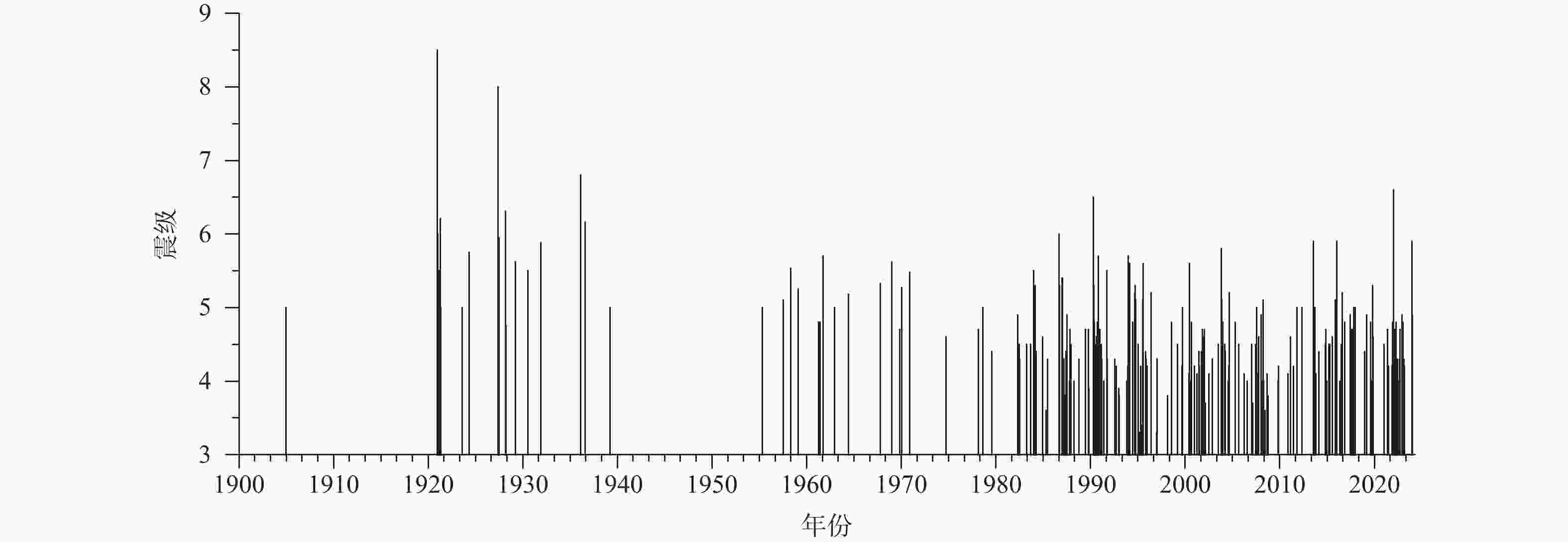
图 5 1900—2024年拉脊山及其邻区中—强震震级−时间(M-T)图
Figure 5. Magnitude-Time (M-T) diagram for moderate to strong earthquakes in Lajishan and neighboring areas from 1900 to 2024
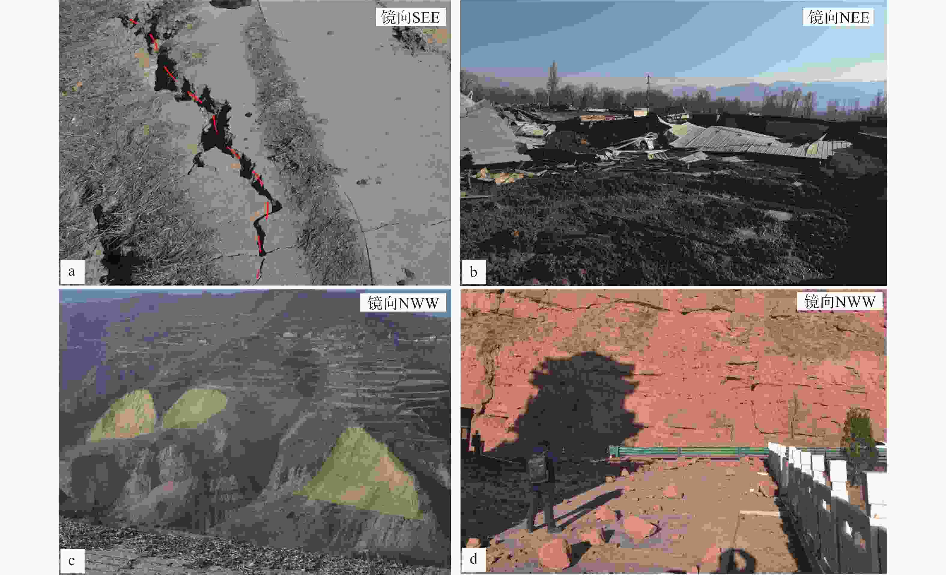
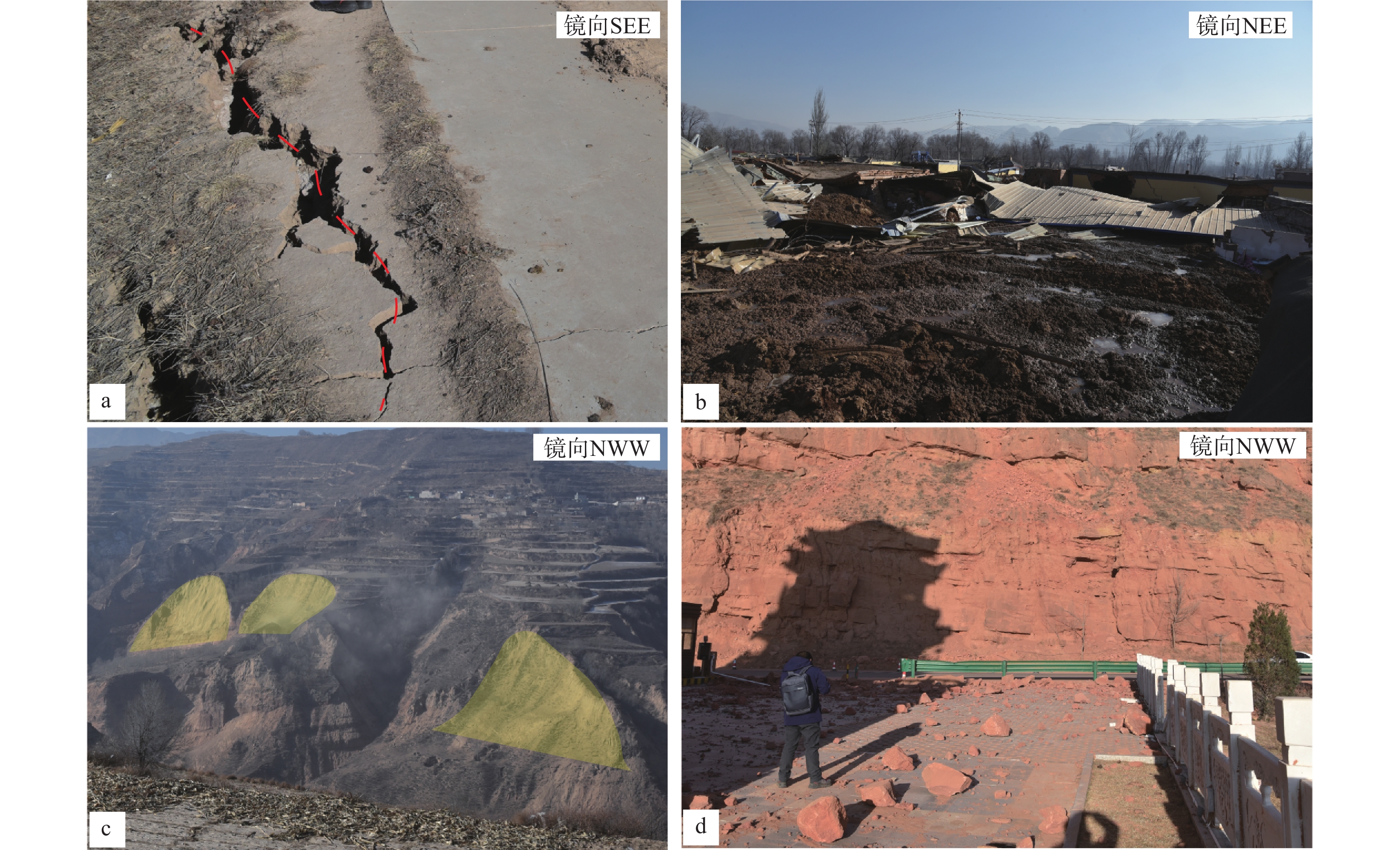
图 6 地质次生灾害点野外调查图
a—积石山县东南侧边坡旁地裂缝;b—中川乡东南侧泥流;c—积石山县东南侧滑坡群;d—大河家镇北侧见崩塌落石
Figure 6. Images of geological hazard sites
(a) Ground cracks in the southeast of Jishishan County; (b) Mudflow in the southeast of Zhongchuan Township; (c) Landslides in the southeast of Jishishan County; (d) Avalanches in the north of Dajiahe Town
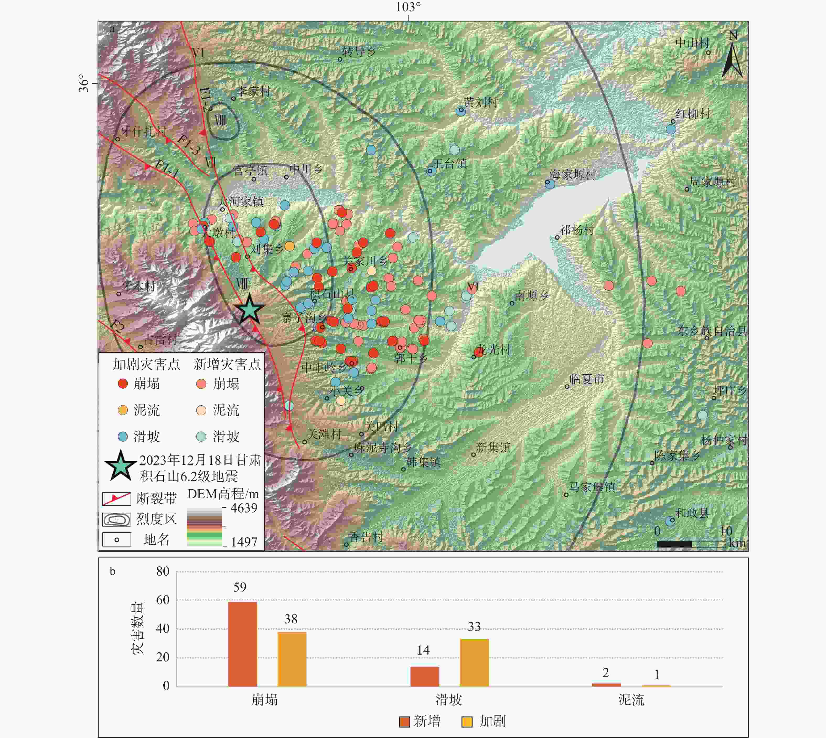
图 7 甘肃积石山地震震后灾害点分布图及数量直方图(灾害点数据来源于甘肃省环境监测院
https://gsigem.gsdkj.net/ )F1-1—拉脊山北缘断裂带西支;F1-2—拉脊山北缘断裂带东支;F1-3—拉脊山北缘断裂带东支反向断层;F2—拉脊山南缘断裂带a—地震次生灾害区域分布图;b—地震次生灾害数量统计图
Figure 7. Distribution of post-earthquake disaster sites and statistical tables for the Jishishan earthquake in Gansu Province (the disaster site data are from the Gansu Provincial Environmental Monitoring Institute; https://gsigem.gsdkj.net/ )
(a) Map of the regional distribution of secondary seismic hazards; (b) Histogram of secondary disasters of earthquakes F1-1: West branch of the Lajishan Fault Zone; F1-2: East branch of the northern margin of the Lajishan Fault Zone; F1-3: Reverse fault of the east branch of the north margin of the Lajishan Fault Zone; F2: South branch of Lajishan Fault Zone
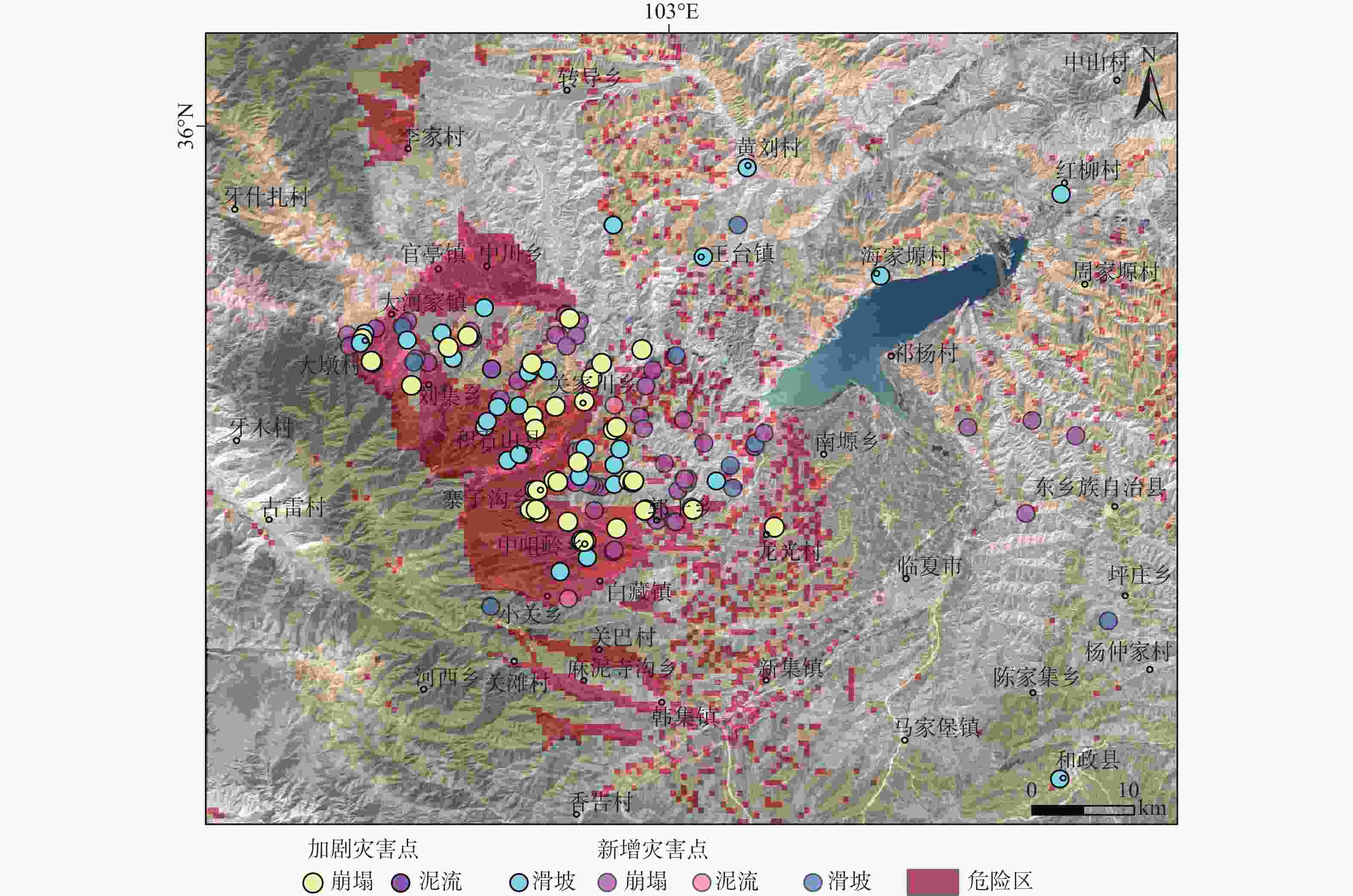
图 8 甘肃积石山地震震后次生灾害综合评价图(灾害点数据来源于甘肃省环境监测院;
https://gsigem.gsdkj.net/ )Figure 8. Comprehensive evaluation of secondary, post-earthquake disasters in Jishishan, Gansu Province (the disaster site data are from the Gansu Provincial Environmental Monitoring Institute;
https://gsigem.gsdkj.net/ )表 1 积石山区域周边5级以上的历史地震表
Table 1. Table of historical earthquakes of magnitude 5 or greater in the area around Jishishan
序号 时间 地点 震级 震中烈度 参考文献 1 1371年1月29日 渭源北 5 VI 梁明剑,2008 2 1901年 兰州西固区南 5 VI 梁明剑,2008 3 1944年 乐都南 5 VI 袁道阳等,2005 4 1590年7月 乐都东 5 VI 袁道阳等,2005 5 1821—1850年 循化 5 VI 袁道阳等,2005 6 1878年10月 榆中高崖 5 VI 梁明剑,2008 7 1629年 兰州 5½ VII 梁明剑,2008 8 1875年2月6日—1875年3月7日 西宁 5½ VII 袁道阳等,2005 9 1890年2月17日 西宁东 5½ VII 袁道阳等,2005 10 1893年6月1日 西宁南 5½ VII 袁道阳等,2005 11 1968年12月22日 化隆西 5.4 VI 袁道阳等,2005 12 1819年2月24日 化隆 5¾ VII 袁道阳等,2005 13 1847年7月12日 西宁 5¾ VII 袁道阳等,2005 14 1590年7月7日 永靖东南 6 VIII 袁道阳等,2007 15 公元406年 榆中县菀川 6 VII 袁道阳等,2001 16 1440年11月4日 永登 6¼ VIII 梁明剑,2008 17 1936年 康乐 6¾ IX 张波等,2015 18 公元138年 金城−陇西 6¾ IX 袁道阳等,2004b 19 1125年8月30日 兰州 7 IX 袁道阳等,2002 20 1927年 古浪 8 XI 谢虹等,2014  下载: 导出CSV
表 2 因子选取说明及其数据来源
Table 2. Description of selected factors and their data sources
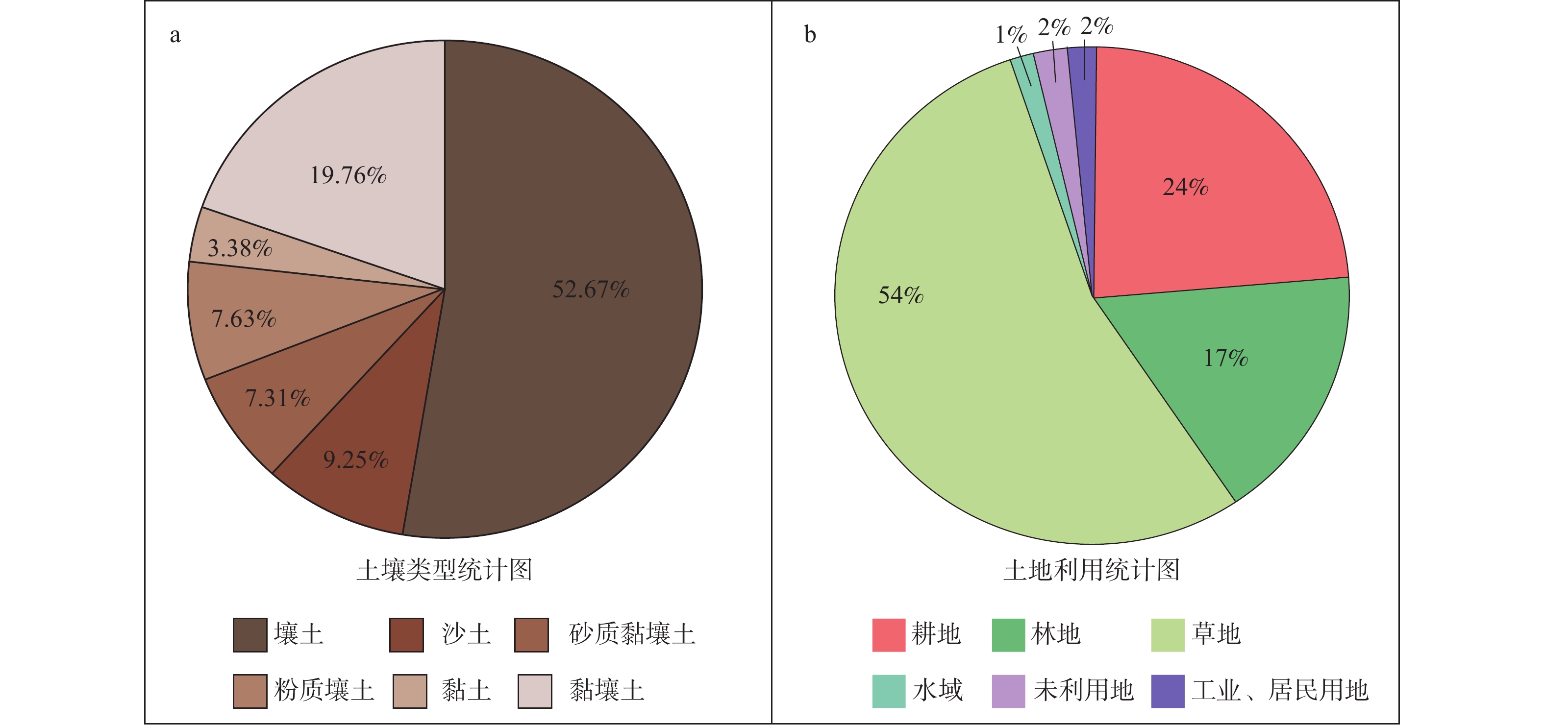
编号 因子 因子内容 数据说明 来源 1 断裂 距断裂距离 指示断裂运动对周边环境影响,靠近断裂危险性越大,远离断裂危险性越小 陆诗铭等,2024 2 地层岩性 地层岩性分区 将地层划分为全新统、古近系及古近系之前与古生代侵入岩等,全新世地层尚未固结成岩,易受地震等影响发育滑坡、泥流、坍塌等灾害 全国地质资料馆https://www.ngac.cn/125cms/c/qggnew/zxfw.htm 3 植被覆盖 植被覆盖分类 根据土地利用分布图绘制植被覆盖图,植被较多的地方土地稳定性大,较难发生滑坡等地质次生灾害 中国科学院地理科学与资源研究所http://www.igsnrr.ac.cn/ 4 坡度 地形特点 坡度越大,则坡体易受地震、降水等影响产生滑坡等地质次生灾害 ALOS DEM (30m分辨率) 5 降水 区域月均降水量 考虑区域降水大小对坡体稳定性影响程度 彭守璋,2020
下载: 导出CSV
表 3 1—9度判断矩阵
Table 3. The AHP judgement matrix from 1 to 9
降水 坡度 植被覆盖 断裂 地层岩性 降水 1.000 0.500 0.333 0.250 0.200 坡度 2.000 1.000 0.500 0.333 0.250 植被覆盖 3.000 2.000 1.000 0.500 0.333 断裂 4.000 3.000 2.000 1.000 0.500 地层岩性 5.000 4.000 3.000 2.000 1.000
下载: 导出CSV
表 4 因子权重表
Table 4. Factor weights
项 特征向量 权重值 最大特征值 CI值 降水 0.312 6.238% 5.068 0.017 坡度 0.493 9.857% 植被覆盖 0.805 16.105% 断裂 1.309 26.179% 地层岩性 2.081 41.621%
下载: 导出CSV
表 5 随机一致性指标
Table 5. Stochastic consistency indicators
n 阶 3 4 5 6 7 8 9 RI值 0.5200 0.8900 1.1200 1.2600 1.3600 1.4100 1.4600 n 阶 10 11 12 13 14 15 16 RI值 1.4900 1.5200 1.5400 1.5600 1.5800 1.5900 1.5943 n 阶 17 18 19 20 21 22 23 RI值 1.6064 1.6133 1.6207 1.6292 1.6358 1.6403 1.6462 n 阶 24 25 26 27 28 29 30 RI值 1.6497 1.6556 1.6587 1.6631 1.667 1.6693 1.6724
下载: 导出CSV
表 6 CR值计算及一致性检验结果表
Table 6. Calculation of the CR value and result of the consistency test
最大特征根 CI值 RI值 CR值 一致性检验结果 5.068 0.017 1.120 0.015 通过
下载: 导出CSV
表 7 评价指标及其分值表
Table 7. Evaluation indicators and their scores
评价指标 指标分类 原始分值 权重分值 总权重//% 地层 全新统 9 3.78 42 古近系 2 0.84 老地层及岩体 1 0.42 断裂 ≤5km 9 2.34 26 5~15km 7 1.82 15~30km 3 0.78 ≥30km 1 0.26 植被覆盖 未利用土地 9 1.44 16 居民、工矿等用地 3 0.48 耕地、草地 2 0.32 林地 1 0.16 水域 0 0 坡度 ≥40° 9 0.9 10 30°~40° 7 0.7 20°~30° 5 0.5 10°~20° 3 0.3 <10° 1 0.1 降水 ≥43mm 9 0.54 6 40~43mm 7 0.42 37~40mm 5 0.3 32~37mm 3 0.18 ≤32mm 1 0.06
下载: 导出CSV
-
[1] BAI Y Z, XU J, XU X W, et al., 2010. Simulations on displacement fields of ground surface in 2008 Wenchuan earthquake: the case of inverse and right-lateral motion of Yingxiu-Beichuan Fault[J]. Seismology and Geology, 32(1): 16-27. (in Chinese with English abstract [2] BAI Z L, JI L Y, ZHU L Y, et al., 2024. Causes and destructive analysis of the liquefied mudflow in Zhongchuan Town triggered by the 2023 Jishishan, Gansu MS6.2 earthquake[J]. China Earthquake Engineering Journal, 46(4): 768-777. (in Chinese with English abstract doi: 10.20000/j.1000-0844.20240110001 [3] CAI F Q, 2013. New discovery and application of some historical data for the M8.0 earthquake in southern Wudu in 1879[J]. China Earthquake Engineering Journal, 35(2): 311-320. (in Chinese with English abstract [4] DOU Q, 2020. Geological environment evaluation of abandoned mines in Shenzhen city based on GIS and AHP[D]. Changchun: Jilin University. DOI: 10.27162/d.cnki.gjlin.2020.005985. (in Chinese with English abstract [5] Food and Agriculture Organization of the United Nations (FAO), 2019. Dataset of soil texture on the Qinghai-Tibet Plateau (2010)[DB]. A Big Earth Data Platform for Three Poles. (in Chinese) [6] GAO B, DONG Y, JIA J, et al., 2024. Development feature and risk assessment of geological hazards caused by the Ms 6.2 earthquake in Jishishan County, Linxia, Gansu Province[J]. Northwestern Geology, 57(2): 209-219. (in Chinese with English abstract [7] GAO M T, 2024. Observations on rural earthquake safety in western China from the Jishishan MS 6.2 earthquake[J]. Overview of Disaster Prevention(1): 4-9. (in Chinese) [8] GAO Y W, KAN W L, 2024. Brief analysis of the earthquake damage and suggestions for investigation of disaster-bearing bodies in Jishishan MS6.2 earthquake, Gansu[J]. Overview of Disaster Prevention(1): 16-21. (in Chinese) [9] GUO F Y, ZHANG Y J, DOU X D, et al., 2024. Distribution patterns and development characteristics of secondary geological hazards caused by the Ms 6.2 earthquake in Jishishan, Gansu[J]. Journal of Lanzhou University (Natural Sciences), 60(1): 6-12. (in Chinese with English abstract doi: 10.13885/j.issn.0455-2059.2024.01.002 [10] GUO S Y, GUO H X, XIN M Y, 2024. Management suggestions for enhancing the earthquake resistance capacity of rural self-built houses: reflections based on the Jishishan earthquake in Gansu[J]. Hubei Emergency Management(3): 56-57. (in Chinese) [11] GUO X Y, HAN L B, ZHANG X, et al., 2024. Source parameters and rupture characteristics of the M6.2 Jishishan earthquake in Gansu Province on December 18, 2023[J]. Progress in Earthquake Sciences, 54(1): 75-85. (in Chinese with English abstract doi: 10.19987/j.dzkxjz.2023-197 [12] LI H B, XU Z Q, WANG H, et al., 2013. The principle slip zone of the 2008 Wenchuan earthquake: a thrust fault oblique cutting the Yingxiu-Beichuan fault zone[J]. Geology in China, 40(1): 121-139. (in Chinese with English abstract [13] LI J L, ZHANG X J, YU H L, et al., 2024. Lajia ruins in Qinghai Province might be caused by seismic-induced liquefaction mudflows of sands and soils: implication from the Jishishan Earthquake in Gansu Province on December 18, 2023[J]. Geoscience, 38(1): 248-259. (in Chinese with English abstract doi: 10.19657/j.geoscience.1000-8527.2024.012 [14] LI Y, ZHOU R J, DENSMORE L A, et al., 2008. Surface rupture and deformation of the Yingxiu-Beichuan fault by the Wenchuan earthquake[J]. Acta Geologica Sinica, 82(12): 1688-1706. (in Chinese with English abstract [15] LI Y B, GAN W J, WANG Y B, et al. , 2017. Seismogenic structure of the 2016 MS6.4 Menyuan earthquake and its effect on the Tianzhu seismic gap[J]. Journal of Geodesy and Geodynamics, 37(8): 792-796, 829. (in Chinese with English abstract [16] LI Z M, LI Y J, TIAN Q J, et al., 2014. Study on the relationship between paleoseismic on Laji mountain fault and catastrophic event on Lajiashan site[J]. Journal of Seismological Research, 37(S1): 109-115. (in Chinese with English abstract [17] LIANG M J, 2008. Earthquake risk assessment on active faults of Lanzhou city[D]. Lanzhou: Lanzhou Institute of Seismology, CEA. (in Chinese with English abstract [18] HE B, WANG T, et al., 2024. Development characteristics and susceptibility assessment of coseismic geological hazards of Jishishan MS6.2 earthquake, Gansu Province, China[J]. Journal of Geomechanics, 30(2): 314-331. (in Chinese with English abstract [19] LU S M, 2022. New activity characteristics and tectonic significance of the western margin of Ganjia basin faults[D]. Lanzhou: Lanzhou Institute of Seismology, CEA. DOI: 10.27491/d.cnki.gzdls.2022.000004. (in Chinese with English abstract [20] LU S M, WU Z H, LI Z C, 2024. Seismic structure characteristics of the 18 December 2023 M6.2 Jishishan earthquake, Gansu Province[J]. Progress in Earthquake Sciences, 54(1): 86-93. (in Chinese with English abstract doi: 10.19987/j.dzkxjz.2024-007 [21] NIU Q F, XIONG C, LEI J J, et al., 2023. Risk assessment of flash flood disasters in Longnan mountain area of Gansu Province based on FFPI model[J]. Journal of Natural Disasters, 32(4): 36-47. (in Chinese with English abstract doi: 10.13577/j.jnd.2023.0404 [22] PENG S Z, 2020. 1-km monthly precipitation dataset for China (1901-2021)[DB]. A Big Earth Data Platform for Three Poles, DOI: 10.5281/zenodo.3185722. (in Chinese) [23] QIANG D X, MA H Z, ZHU Z P, et al. , 2022. Spatial distribution and analysis of debris flow in Jishishan County of Gansu province[J]. Bulletin of Surveying and Mapping(7): 107-111, 117. DOI: 10.13474/j.cnki.11-2246.2022.0212. (in Chinese with English abstract [24] QIAO B, GUO J X, JIA N, et al., 2024. Analysis and research on the evaluation index system of earthquake emergency response capacity of earthquake monitoring center station based on AHP method[J]. Journal of Catastrophology, 39(2): 172-177. (in Chinese with English abstract [25] SONG F M, YUAN D Y, CHEN G H, et al., 2007. Pattern and combination features of the surface ruptures of the 1125 A. D. Lanzhou M 7 earthquake[J]. Seismology and Geology, 29(4): 834-844. (in Chinese with English abstract [26] SU R H, YUAN D Y, XIE H, et al., 2023. Classified surface rupture characteristics and damage analysis of the 2022 MS6.9 Menyuan earthquake, Qinghai[J]. Acta Seismologica Sinica, 45(5): 797-813. (in Chinese with English abstract doi: 10.11939/jass.20220075 [27] WANG M, SHEN Z K, 2020. Present‐day crustal deformation of continental China derived from GPS and its tectonic implications[J]. Journal of Geophysical Research: Solid Earth, 125(2): e2019JB018774. doi: 10.1029/2019JB018774 [28] WU Z H, ZHOU C J, TAN C X, et al., 2016. The active tectonics and regional crustal stability features in the area of Yangtze River economic belt[J]. Journal of Geomechanics, 22(3): 379-411. (in Chinese with English abstract [29] WU Z H, ZHOU C J, 2018. Distribution map of active faults in China and its adjacent sea area (1: 5, 000, 000)[M]//HAO A B, LI R M. Atlas sets of geological environment of China. Beijing: Geological Publishing House. (in Chinese) [30] XIANG Z, LI Q F, WANG C R, et al., 2023. Analysis on development characteristics and disaster-pregnant environmental conditions of geological disasters in Huangping County, southeastern Guizhou Province[J]. Resources Environment & Engineering, 37(3): 320-327. (in Chinese with English abstract doi: 10.16536/j.cnki.issn.1671-1211.2023.03.009 [31] XIE H, YUAN D Y, LEI Z S, et al., 2014. Seismic hazard characteristics of and lessons from Gulang Ms 8 earthquake in 1927[J]. Journal of Lanzhou University (Natural Sciences), 50(5): 622-627. (in Chinese with English abstract doi: 10.13885/j.issn.0455-2059.2014.05.007 [32] XU Y N, LIU G Y, 2023. Susceptibility evaluation of geological disasters in a key town of Shiyan City[J]. Energy and Environment(6): 139-142. (in Chinese) [33] YANG W H, YANG Z Q, ZHAO J L, et al. , 2021. Research on the risk of collapse and landslide in Wenchuan earthquake disaster area based on logistic regression model[J]. Hubei Agricultural Sciences, 60(6): 42-48, 59. (in Chinese with English abstract [34] YANG Z X, 1993. On the overthrust zone in the north margin of the Lajishan, the Southern Qilian Mountains[J]. Experimental Petroleum Geology, 15(2): 138-145. (in Chinese with English abstract [35] YUAN D Y, LEI Z S, LIU B C, et al. , 2001. Preliminary research on the 406 Wenchuan earthquake (My≈6) in Yuzhong Country, Lanzhou[C]//Proceedings of the research and disaster mitigation academic conference of China's eight magnitude earthquakes. Lanzhou: Seismological Society of China. (in Chinese) [36] YUAN D Y, LEI Z S, LIU B C, et al., 2002. Textual research on the 1125 Lanzhou M7.0 earthquake and the causative structure[J]. Earthquake Research in China, 18(1): 67-75. (in Chinese with English abstract [37] YUAN D Y, ZHANG P Z, LIU B C, et al., 2004a. Geometrical imagery and tectonic transformation of late Quaternary active tectonics in northeastern margin of Qinghai-Xizang Plateau[J]. Acta Geologica Sinica, 78(2): 270-278. (in Chinese with English abstract doi: 10.3321/j.issn:0001-5717.2004.02.017 [38] YUAN D Y, LEI Z S, LIU X F, et al., 2004b. Textual research on the historical data of the 138 AD Jincheng-Longxi M6¾ earthquake and discussion on its seismogenic structural background[J]. Seismology and Geology, 26(1): 52-60. (in Chinese with English abstract [39] YUAN D Y, ZHANG P Z, LEI Z S, et al., 2005. A preliminary study on the new activity features of the Lajishan mountain fault zone in Qinghai Province[J]. Earthquake Research in China, 21(1): 93-102. (in Chinese with English abstract [40] YUAN D Y, LEI Z S, ZHANG J L, et al., 2007. Textual research on July 7, 1590 A. D. Yongjing earthquake in Gansu Province[J]. Technology for Earthquake Disaster Prevention, 2(2): 158-165. (in Chinese with English abstract [41] ZHANG B, 2012. The study of new activities on western segment of northern margin of Western Qinling fault and Laji Shan fault[D]. Lanzhou: Lanzhou Institute of Seismology, CEA. (in Chinese with English abstract [42] ZHANG B, HE W G, FANG L H, et al., 2015. Surveys on surface rupture phenomena of Gansu Kangle M¾ earthquake in 1936[J]. Journal of Seismological Research, 38(2): 262-271. (in Chinese with English abstract [43] ZHANG Z Z, ZHANG T D, YU X K, et al., 2023. Zonation of disaster environments of collapse, landslide and debris flow geologic hazards and their formation mechanisms in Xinjiang[J]. Journal of Engineering Geology, 31(4): 1129-1144. (in Chinese with English abstract doi: 10.13544/j.cnki.jeg.2023-0214 [44] ZHAO J Y, TIAN S J, LI K, et al., 2024. Susceptibility assessment of debris flow in the upper reaches of the Minjiang River before and after the Wenchuan earthquake[J]. The Chinese Journal of Geological Hazard and Control, 35(1): 51-59. (in Chinese with English abstract [45] ZHAO W, ZHOU J, CHEN K J, et al., 2022. Sensitivity analysis on hazard - formative environmental factors for wind disasters caused by typhoon in Zhejiang power grid[J]. Journal of Catastrophology, 37(3): 118-121, doi: 10.3969/j.issn.1000-811X.2022.03.019 [46] ZHENG W J, MIN W, HE W G, et al., 2013. Distribution of the related disaster and the causative tectonic of the Minxian-Zhanxian MS6.6 earthquake on July 22, 2013, Gansu, China[J]. Seismology and Geology, 35(3): 604-615. (in Chinese with English abstract [47] ZHENG W J, ZHANG P Z, YUAN D Y, et al., 2019. Basic characteristics of active tectonics and associated geodynamic processes in continental China[J]. Journal of Geomechanics, 25(5): 699-721. (in Chinese with English abstract doi: 10.12090/j.issn.1006-6616.2019.25.05.062 [48] China Earthquake Administration, 2015. Earthquake Intensity Zoning Map of China: GB 18306-2015[S]. Beijing: Standards Press of China. (in Chinese) [49] ZHOU C J, WU Z H, MA X X, et al., 2016. The major active faults and regional crustal stability assessment in the area of city group in central Yunnan[J]. Journal of Geomechanics, 22(3): 454-477. (in Chinese with English abstract [50] ZHOU J, MA S P, 2024. SPSSAU scientific data analysis methods and applications[M]. Beijing: Publishing House of Electronics Industry. (in Chinese) [51] 白玉柱,徐杰,徐锡伟,等,2010. 2008年汶川8.0级地震地表位移场的模拟:映秀-北川断裂逆冲兼右旋走滑错动形成的地表位移场[J]. 地震地质,32(1):16-27. [52] 白卓立,季灵运,朱良玉,等,2024. 2023年甘肃积石山MS6.2地震中川乡泥流成因及破坏性分析[J]. 地震工程学报,46(4):768-777. doi: 10.20000/j.1000-0844.20240110001. [53] 蔡副全,2013. 1879年武都南8级地震新资料的发现与应用[J]. 地震工程学报,35(2):311-320. [54] 窦强,2020. 基于GIS和层次分析法的深圳市废弃矿山地质环境评价[D]. 长春:吉林大学. DOI: 10.27162/d.cnki.gjlin.2020.005985. [55] 高波,董英,贾俊,等,2024. 甘肃临夏积石山县6.2级地震地质灾害发育特征及危险性评价[J]. 西北地质,57(2):209-219. [56] 高孟潭,2024. 从积石山6.2级地震看西部农村地震安全[J]. 防灾博览(1):4-9. [57] 高永武,阚文亮,2024. 甘肃积石山6.2级地震震害简析及承灾体调查建议[J]. 防灾博览(1):16-21. [58] 郭富赟,张永军,窦晓东,等,2024. 甘肃积石山Ms 6.2地震次生地质灾害分布规律与发育特征[J]. 兰州大学学报(自然科学版),60(1):6-12. doi: 10.13885/j.issn.0455-2059.2024.01.002. [59] 郭聖煜,郭海湘,辛美仪,2024. 关于提升农村自建房抗震能力的管理建议:基于甘肃积石山地震的思考[J]. 湖北应急管理(3):56-57. [60] 郭祥云,韩立波,张旭,等,2024. 2023年12月18日甘肃积石山6.2级地震震源参数和破裂特征[J]. 地震科学进展,54(1):75-85. DOI: 10.19987/j.dzkxjz.2023-197. [61] 李海兵,许志琴,王焕,等,2013. 汶川地震主滑移带(PSZ):映秀—北川断裂带内的斜切逆冲断裂[J]. 中国地质,40(1):121-139. [62] 李俊磊,张绪教,鱼海麟,等,2024. 青海喇家遗址极可能由地震导致的砂土液化泥流造成:“12·18”积石山地震的启示[J]. 现代地质,38(1):248-259. doi: 10.19657/j.geoscience.1000-8527.2024.012. [63] 李彦宝,甘卫军,王阅兵,等,2017. 2016年门源MS6.4强震的发震构造及其对“天祝地震空区”的影响[J]. 大地测量与地球动力学,37(8):792-796,829. doi: 10.14075/j.jgg.2017.08.005. [64] 李勇,周荣军,DENSMORE A L,等,2008. 映秀-北川断裂的地表破裂与变形特征[J]. 地质学报,82(12):1688-1706. [65] 李智敏,李延京,田勤俭,等,2014. 拉脊山断裂古地震与喇家遗址灾变事件关系研究[J]. 地震研究,37(S1):109-115. [66] 联合国粮食及农业组织(FAO),2019. 青藏高原土壤质地数据集(2010)[DB]. 时空三极环境大数据平台. [67] 梁明剑,2008. 兰州市活断层地震危险性评价[D]. 兰州:中国地震局兰州地震研究所. [68] 刘帅,何斌,王涛,等,2024. 甘肃积石山县MS6.2地震同震地质灾害发育特征与易发性评价[J]. 地质力学学报,30(2):314-331. [69] 陆诗铭,2022. 甘加盆地西缘断裂新活动特征与构造意义[D]. 兰州:中国地震局兰州地震研究所. DOI: 10.27491/d.cnki.gzdls.2022.000004. [70] 陆诗铭,吴中海,李智超,2024. 2023年12月18日甘肃省积石山6.2级地震的控震构造及特征[J]. 地震科学进展,54(1):86-93. doi: 10.19987/j.dzkxjz.2024-007. [71] 牛全福,熊超,雷姣姣,等,2023. 基于FFPI模型的甘肃陇南山区山洪灾害风险评价[J]. 自然灾害学报,32(4):36-47. doi: 10.13577/j.jnd.2023.0404. [72] 彭守璋,2020. 中国1 km分辨率逐月降水量数据集(1901-2021)[DB]. 时空三极环境大数据平台. DOI: 10.5281/zenodo.3185722. [73] 强德霞,马海政,朱自平,等,2022. 甘肃省积石山县泥石流空间分布及分析[J]. 测绘通报(7):107-111,117. DOI: 10.13474/j.cnki.11-2246.2022.0212. [74] 乔波,郭建兴,贾宁,等,2024. 基于AHP方法的地震监测中心站地震应急能力评价指标体系分析研究[J]. 灾害学,39(2):172-177. [75] 宋方敏,袁道阳,陈桂华,等,2007. 1125年兰州7级地震地表破裂类型及其分布特征[J]. 地震地质,29(4):834-844. [76] 苏瑞欢,袁道阳,谢虹,等,2023. 2022年青海门源MS6.9地震地表破裂特征分类及震害分析[J]. 地震学报,45(5):797-813. doi: 10.11939/jass.20220075. [77] 吴中海,周春景,谭成轩,等,2016. 长江经济带地区活动构造与区域地壳稳定性基本特征[J]. 地质力学学报,22(3):379-411. [78] 吴中海,周春景,2018. 中国及毗邻海区活动断裂分布图(1∶500万)[M]//郝爱兵,李瑞敏. 中国地质环境图系(图件编号:00-01-05). 北京:地质出版社. [79] 向钊,李青峰,王春仁,等,2023. 黔东南黄平县地质灾害发育特征与孕灾环境条件分析[J]. 资源环境与工程,37(3):320-327. [80] 谢虹,袁道阳,雷中生,等,2014. 1927年古浪8级地震的震灾特征与启示[J]. 兰州大学学报(自然科学版),50(5):622-627. doi: 10.13885/j.issn.0455-2059.2014.05.007. [81] 徐亚宁,刘钢一,2023. 十堰市某重点集镇地质灾害易发性评价研究[J]. 能源与环境(6):139-142. [82] 杨伟华,杨志强,赵建林,等,2021. 基于逻辑回归模型的汶川地震灾区崩塌滑坡易发性评估[J]. 湖北农业科学,60(6):42-48,59. [83] 杨中轩,1993. 南祁连拉脊山北缘逆冲推覆构造带[J]. 石油实验地质,15(2):138-145. doi: 10.11781/sysydz199302138 [84] 袁道阳,雷中生,刘百篪,等,2001. 兰州榆中406年菀川6级地震的初步研究[C]//中国八级大震研究及防震减灾学术会议论文集. 兰州:中国地震学会. [85] 袁道阳,雷中生,刘百篪,等,2002. 兰州1125年7级地震考证与发震构造分析[J]. 中国地震,18(1):67-75. doi: 10.3969/j.issn.1001-4683.2002.01.007 [86] 袁道阳,张培震,刘百篪,等,2004a. 青藏高原东北缘晚第四纪活动构造的几何图像与构造转换[J]. 地质学报,78(2):270-278. doi: 10.3321/j.issn:0001-5717.2004.02.017. [87] 袁道阳,雷中生,刘小凤,等,2004b. 138年金城-陇西6¾级地震的史料考证与发震构造背景探讨[J]. 地震地质,26(1):52-60. [88] 袁道阳,张培震,雷中生,等,2005. 青海拉脊山断裂带新活动特征的初步研究[J]. 中国地震,21(1):93-102. [89] 袁道阳,雷中生,张俊玲,等,2007. 1590年7月7日甘肃永靖东南地震考证[J]. 震灾防御技术,2(2):158-165. doi: 10.11899/zzfy20070207 [90] 张波,2012. 西秦岭北缘断裂西段与拉脊山断裂新活动特征研究[D]. 兰州:中国地震局兰州地震研究所. [91] 张波,何文贵,方良好,等,2015. 1936年甘肃康乐6¾级地震地表破裂带调查[J]. 地震研究,38(2):262-271. [92] 张紫昭,张天栋,于喜坤,等,2023. 新疆崩滑流地质灾害孕灾环境分区及其形成机制[J]. 工程地质学报,31(4):1129-1144, doi: 10.13544/j.cnki.jeg.2023-0214. [93] 赵佳忆,田述军,李凯,等,2024. 岷江上游汶川地震前后泥石流易发性评价[J]. 中国地质灾害与防治学报,35(1):51-59. [94] 赵伟,周娟,陈科技,等,2022. 浙江电网台风风灾的孕灾环境因子敏感性分析[J]. 灾害学,37(3):118-121, doi: 10.3969/j.issn.1000-811X.2022.03.019. [95] 郑文俊,闵伟,何文贵,等,2013. 2013年甘肃岷县漳县6.6级地震震害分布特征及发震构造分析[J]. 地震地质,35(3):604-615. [96] 郑文俊,张培震,袁道阳,等,2019. 中国大陆活动构造基本特征及其对区域动力过程的控制[J]. 地质力学学报,25(5):699-721, doi: 10.12090/j.issn.1006-6616.2019.25.05.062. [97] 中国地震局, 2015. 中国地震动参数区划图:GB 18306-2015[S]. 北京:中国标准出版社. [98] 周春景,吴中海,马晓雪,等,2016. 滇中城市群重要活动断裂与区域地壳稳定性评价[J]. 地质力学学报,22(3):454-477. [99] 周俊,马世澎,2024. SPSSAU科研数据分析方法与应用[M]. 北京:电子工业出版社. -

 下载:
下载:


计量
- 文章访问数: 2279
- HTML全文浏览量: 519
- PDF下载量: 82
- 被引次数: 0
