

Tectonic stability of the Nanpu sag: Evidence from temporal and spatial characteristics of seismic activity
-
摘要: 区域构造稳定性评价在重大工程的规划和建设中发挥着重要的参考作用。目前南堡凹陷作为中国海上储气库的建设地,其构造稳定性成为关注的热点。基于区域历史地震数据,总结了南堡凹陷及周边地震活动的时空分布规律,分析了唐山−河间−磁县断裂带和张家口−蓬莱断裂带的破裂模式,探讨了南堡凹陷地壳的构造稳定性。研究结果表明,南堡凹陷是活动构造带附近相对稳定的“安全岛”。区域上,南堡凹陷周缘积累的应力主要通过滦县−乐亭和宝坻−宁河等断裂带活动得以释放,周缘的地震活动对南堡凹陷内部的影响十分有限;而在南堡凹陷的内部,发育一个以蠕滑为主的大型伸展变形系统。根据现今的构造应力背景,南堡凹陷内的应力仅需要积累很小的量级就会诱发先存正断层的不稳定滑动,这意味着应力无法长期积累。因此,南堡凹陷内部不具备发生大地震的条件。Abstract:
Objective The evaluation of regional tectonic stability plays a crucial role in the planning and construction of major projects. Given that the Nanpu sag is the site for China's first offshore gas storage facility, its tectonic stability is naturally a focal point of concern. Methods Based on historical seismic data for the region, this study summarizes the spatiotemporal distribution of seismic activities in the Nanpu sag and its surrounding areas. It analyzes the rupture modes of the Tangshan−Hejian−Cixian fault zone and the Zhangjiakou−Penglai fault zone, and explores the tectonic stability of the Nanpu sag. Results The results indicate that the Nanpu sag is a relatively stable "safe island" near active tectonic zones. Regionally, stress accumulated around the periphery of the Nanpu sag is mainly released through the activity of faults such as the Luanxian−Laoting and Baodi−Ninghe faults, and the influence of the seismic activity at the periphery on the interior of the Nanpu sag is limited. Internally, a large-scale creep-dominated extensional deformation system has developed within the Nanpu sag. Conclusion Given the current tectonic stress background, only a small magnitude of stress accumulation is required to trigger unstable sliding of pre-existing normal faults within the Nanpu sag. This suggests that stress cannot accumulate over long time scales, and thus the interior of the Nanpu sag lacks conditions for the occurrence of major earthquakes. -
Key words:
- rupture model of fault zone /
- seismic activities /
- tectonic stability /
- Nanpu sag /
- tectonic stress
-
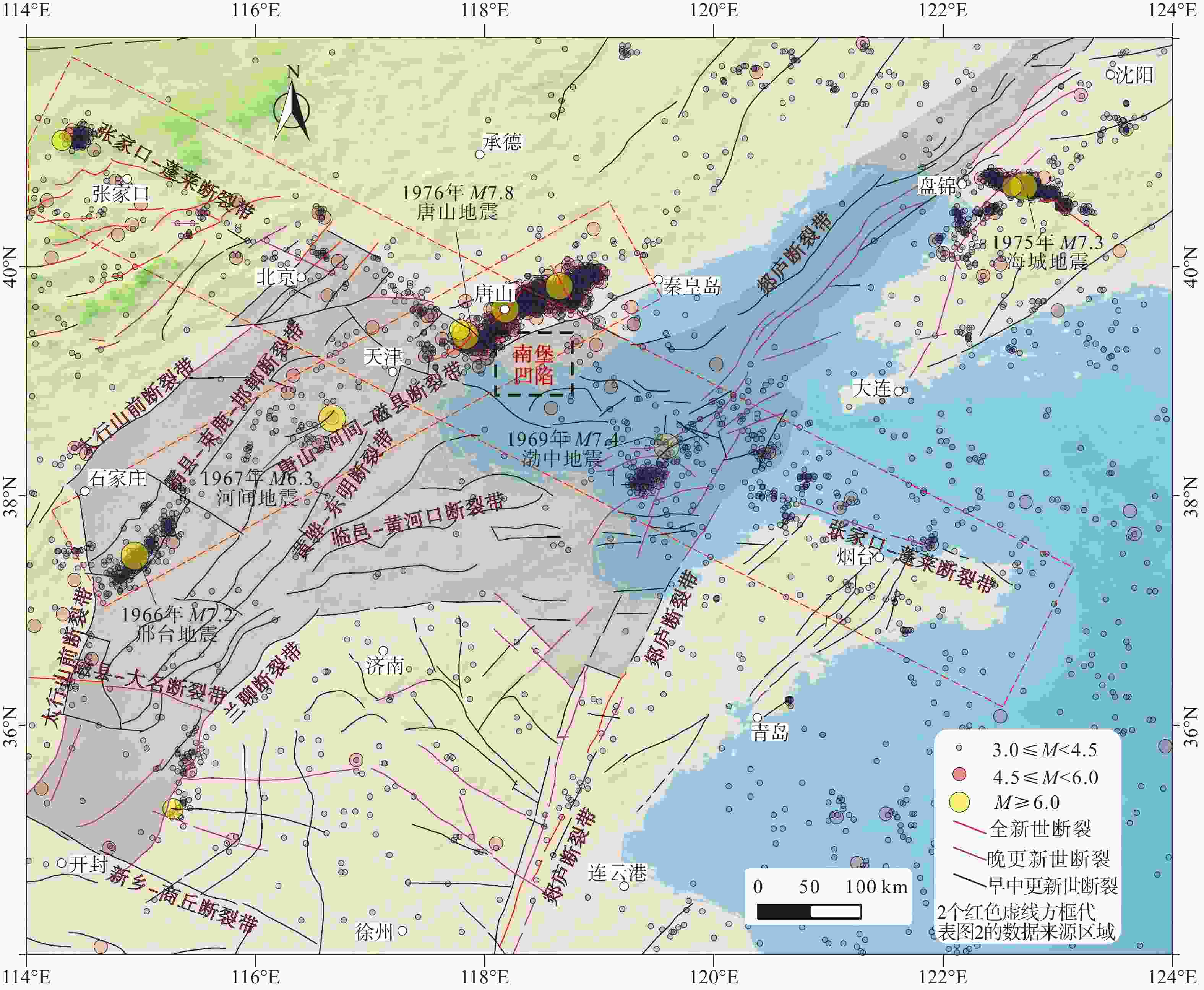
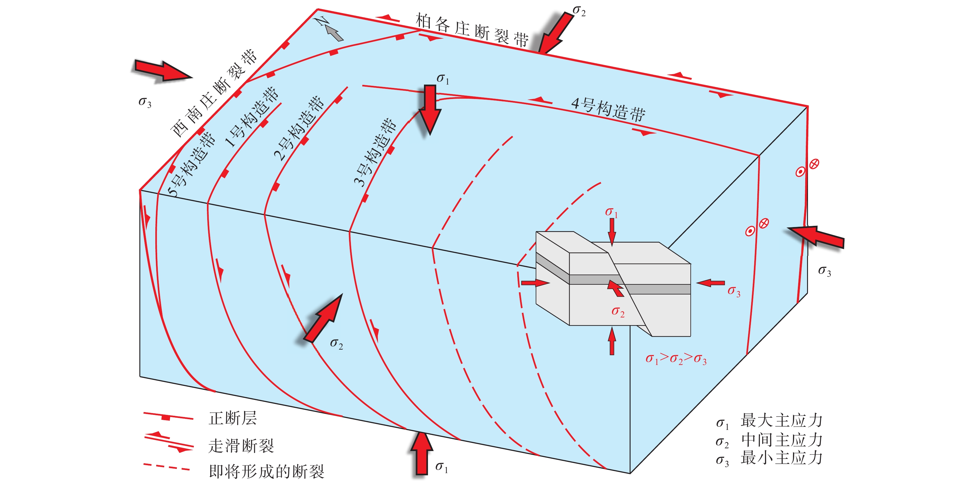
图 1 渤海湾盆地(灰色范围)及周缘地区活动构造纲要图
活动构造数据引自邓起东,2007;历史地震数据引自闵子群等(1995)及国家地震科学数据中心
http://data.earthquake.cn Figure 1. Active tectonic map of the Bohai Bay Basin (gray area) and its periphery
The active faults are from Deng, 2007. Historical earthquake data are from Min et al., 1995, National Earthquake Data Center
http://data.earthquake.cn, and The First Monitoring and Application Center, CEA.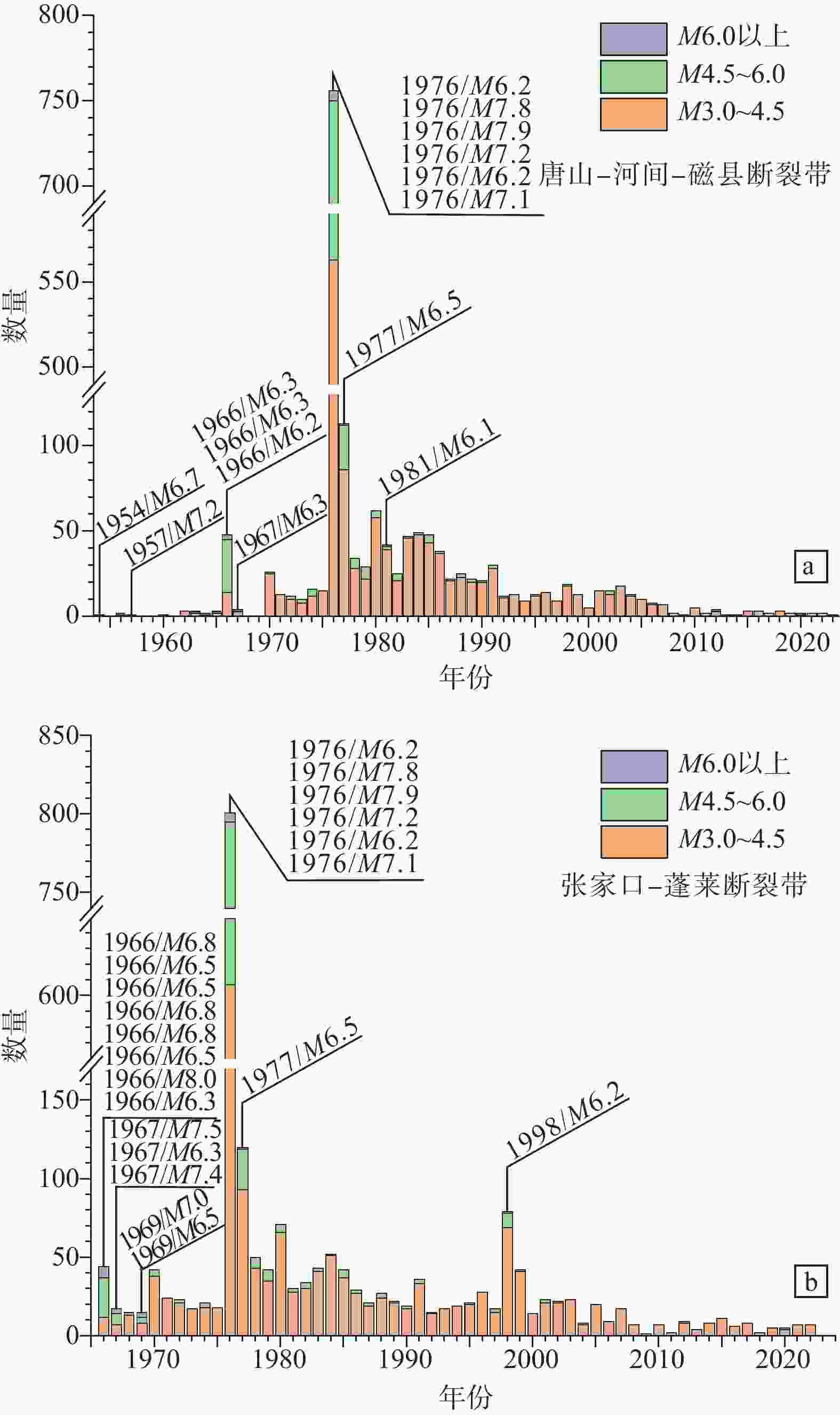
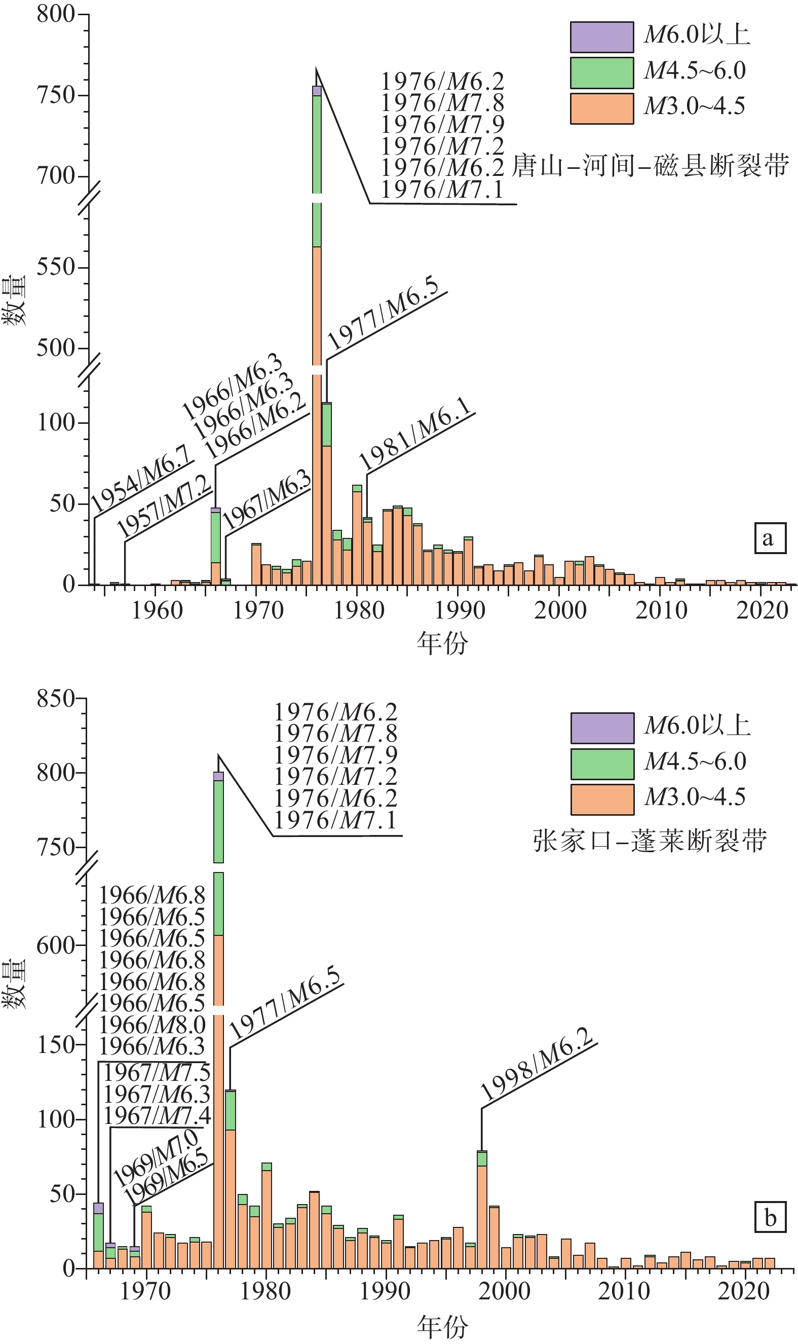
图 2 唐山−河间−磁县断裂带和张家口−蓬莱断裂带历史地震时间频率图
a—唐山−河间−磁县断裂带历史地震时间频率图;b—张家口−蓬莱断裂带历史地震时间频率图
Figure 2. Time-frequency chart of historical earthquakes at the Tangshan−Hejian−Cixian and Zhangjiakou−Penglai fault zones
(a) Time-frequency chart of historical earthquakes at the Tangshan−Hejian−Cixian fault zone; (b) Time-frequency chart of historical earthquakes at the Zhangjiakou−Penglai fault zone
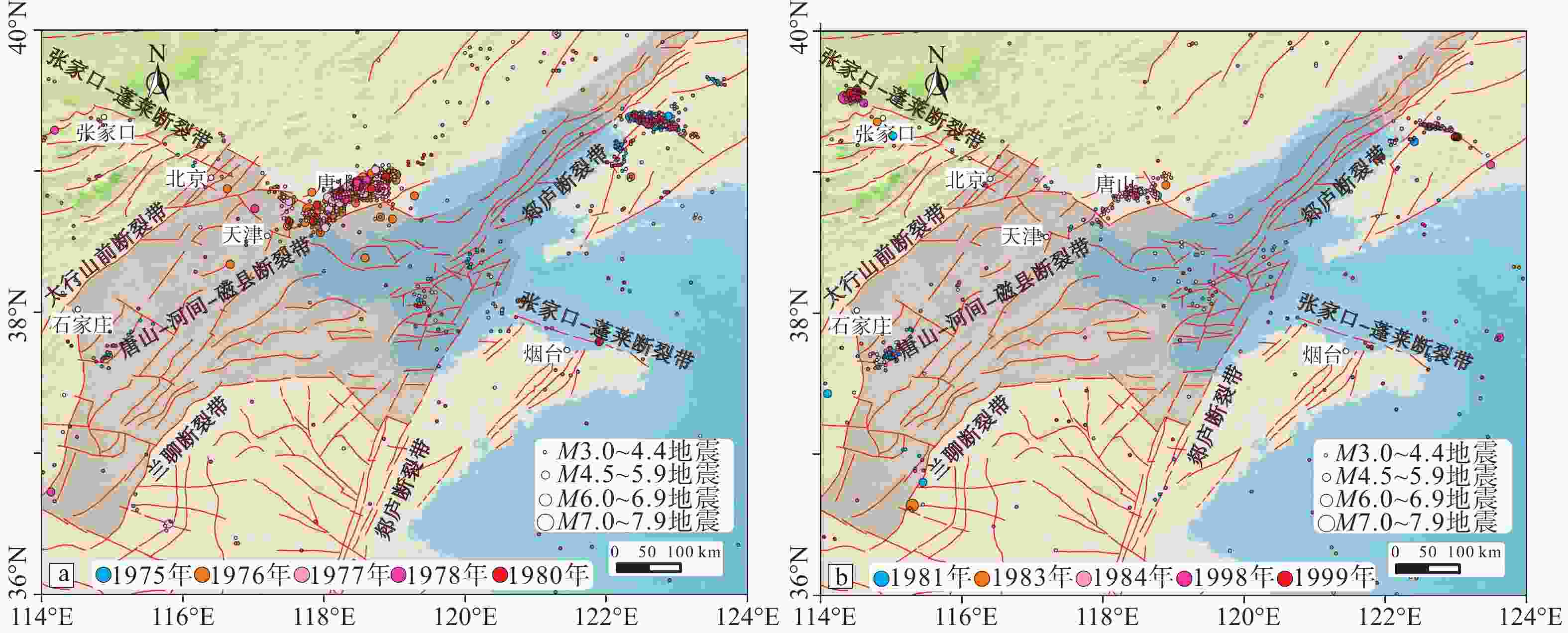
图 3 渤海湾盆地及其周缘不同年份地震分布图(图中红色线条为断裂/带)
a—1975—1980年;b—1981—1999年
Figure 3. Distribution of earthquakes in the Bohai Bay Basin and its periphery in different years (the red lines are fault zones)
(a) Earthquakes from 1975 to 1980; (b) Earthquakes from 1981 to 1999
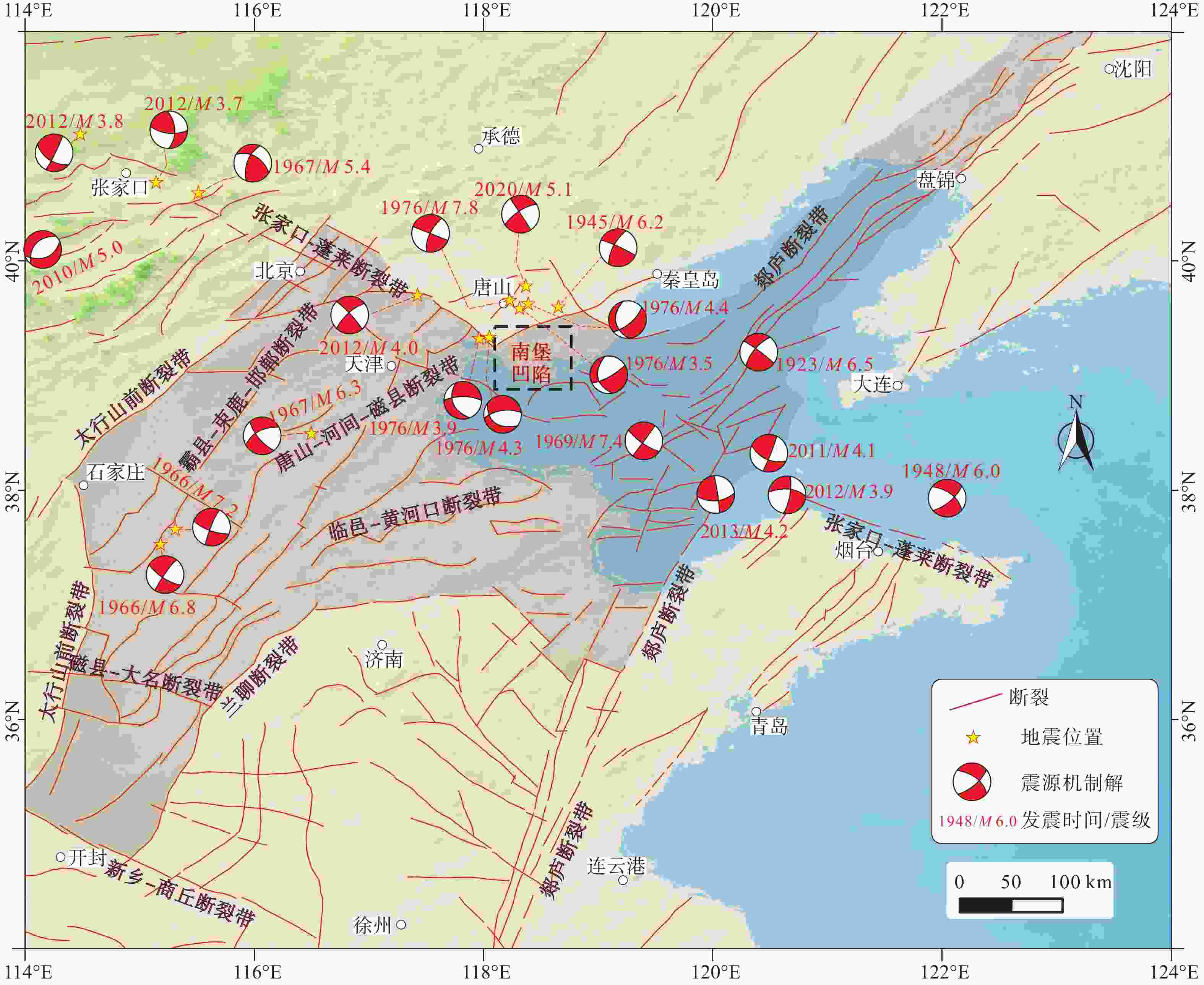
图 4 唐山−河间−磁县断裂带和张家口−蓬莱断裂带相关的震源机制解(Chen and Nábelek,1988;徐杰等,1996;张宏志等,2008;高彬等,2016;林向东等,2017;王想等,2021;Zhang et al.,2022)
Figure 4. Focal mechanism solutions of earthquakes related to the Tangshan−Hejian−Cixian and the Zhangjiakou−Penglai fault zones (data from Chen and Nábelek, 1988; Xu et al., 1996; Zhang et al., 2008; Gao et al., 2016; Lin et al., 2017; Wang et al., 2021; Zhang et al., 2022)
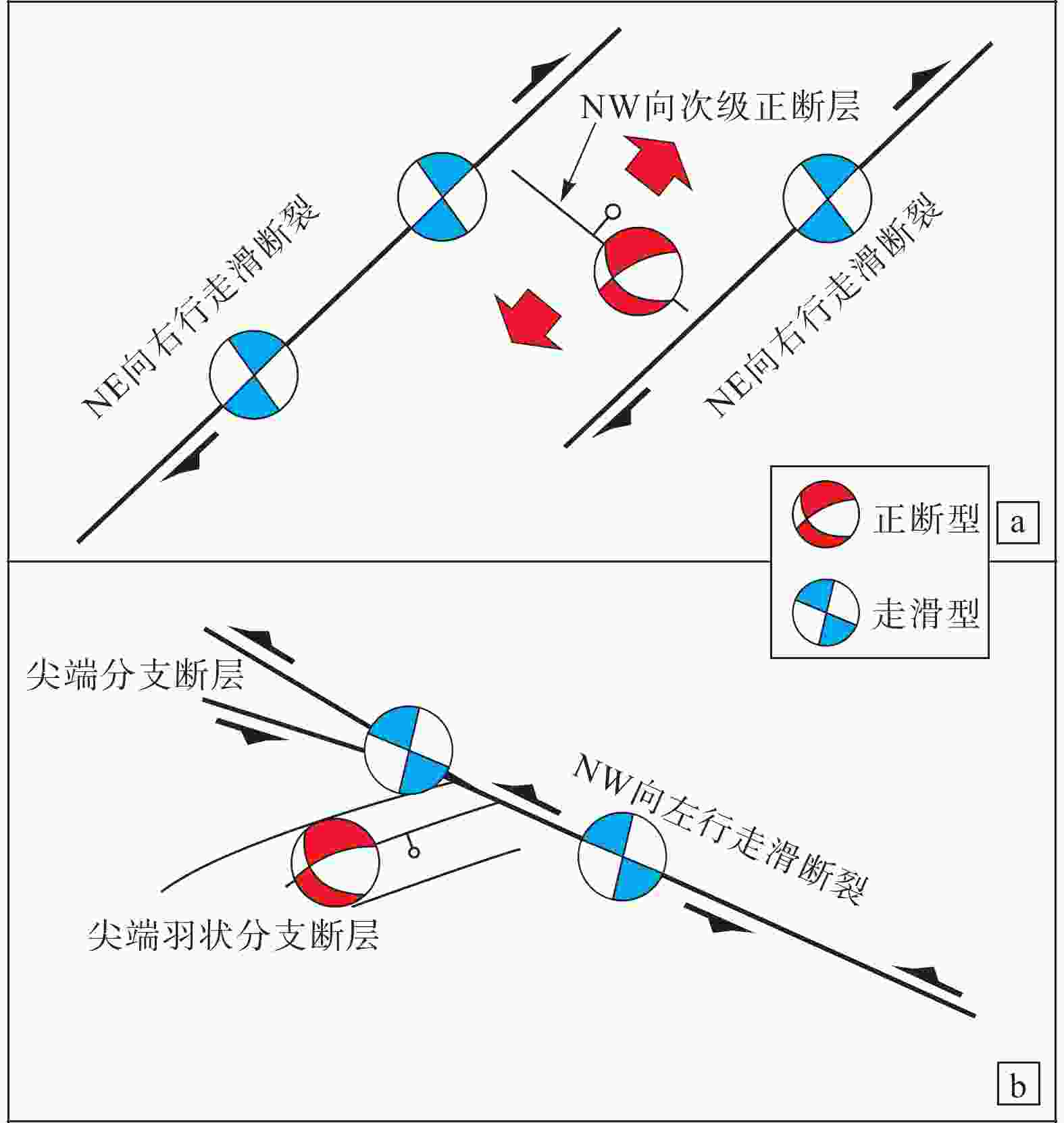
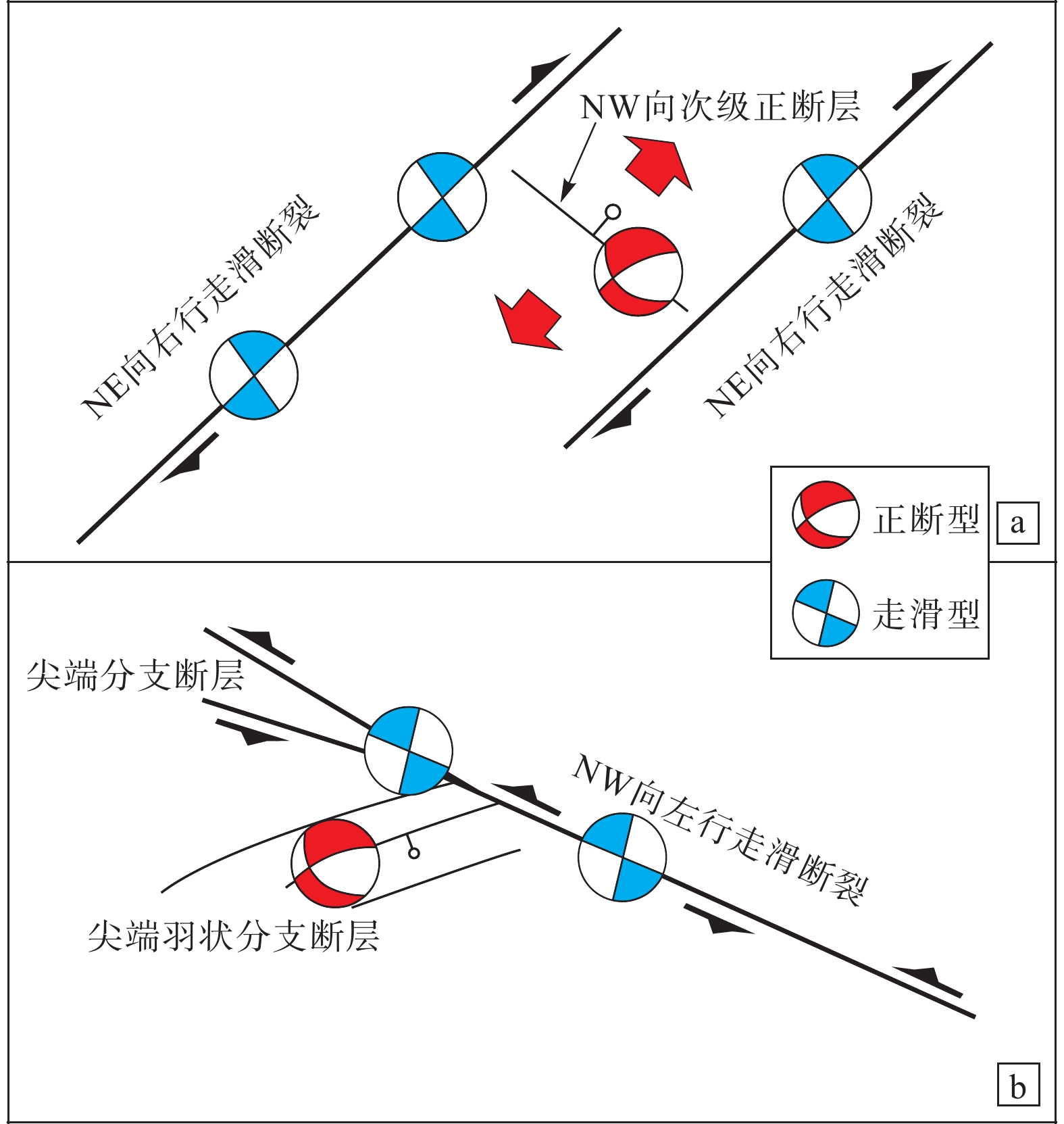
图 5 断裂带破裂构造模式图
a—唐山−河间−磁县断裂带破裂构造模式图;b—张家口−蓬莱断裂带破裂构造模式图
Figure 5. Damage models of the fault zones
(a) Damage model of the Tangshan−Hejian−Cixian fault zone; (b) Damage model of the Zhangjiakou−Penglai fault zone
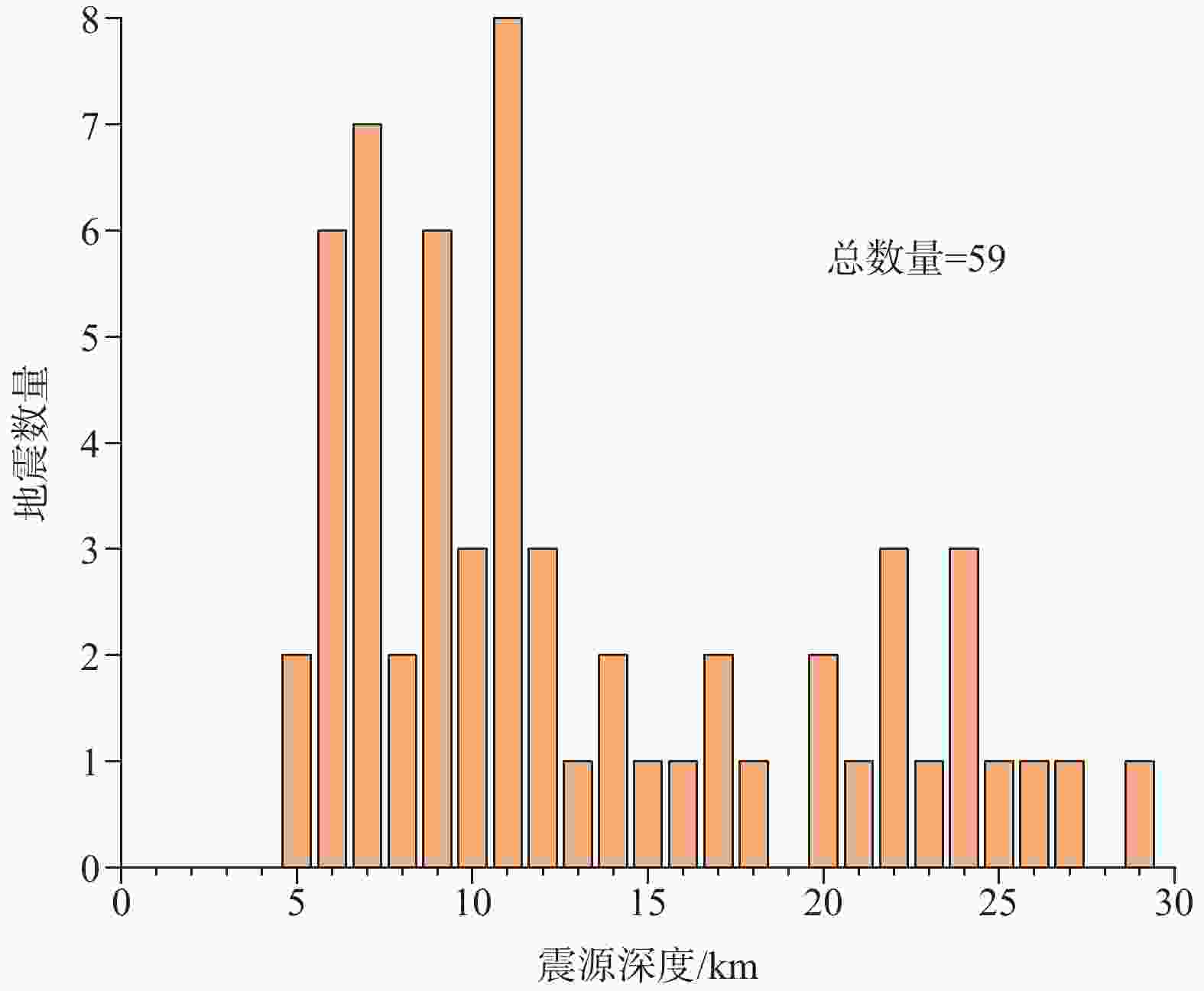
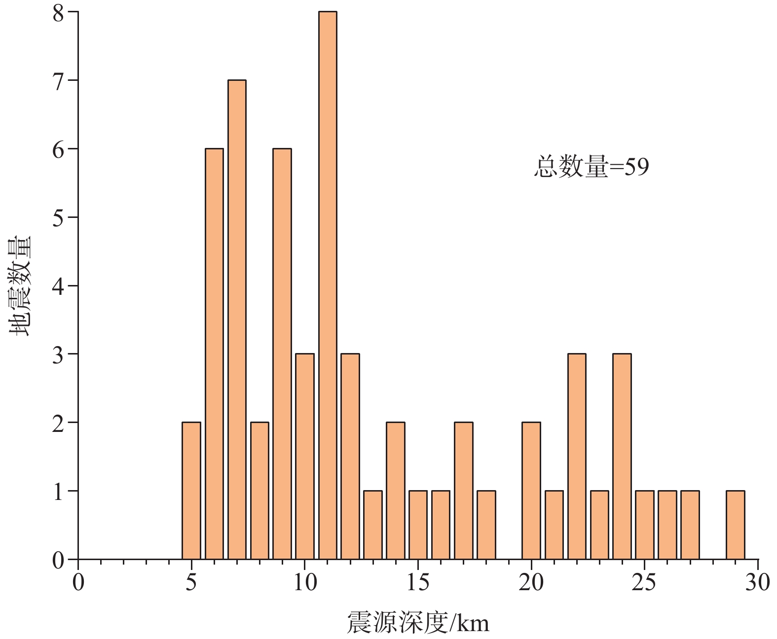
图 6 南堡凹陷历史地震震源深度分布图
Figure 6. Distribution of the hypocenter depth of historical earthquakes in the Nanpu sag
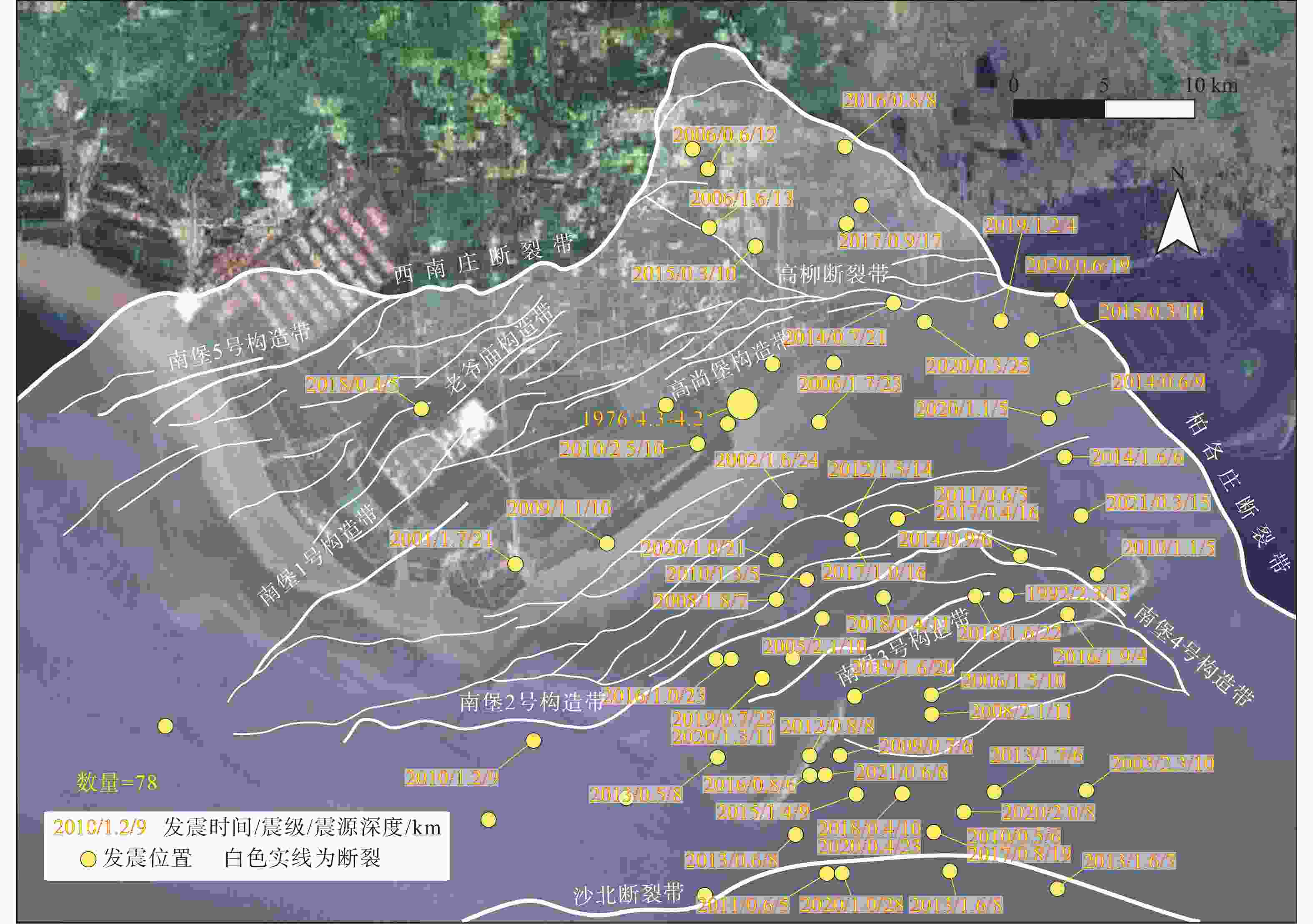
图 7 南堡凹陷内历史地震分布图(地震数据来源与图1相同)
Figure 7. Distribution of historical earthquakes in the Nanpu sag (seismic data from the same source as Fig. 1)
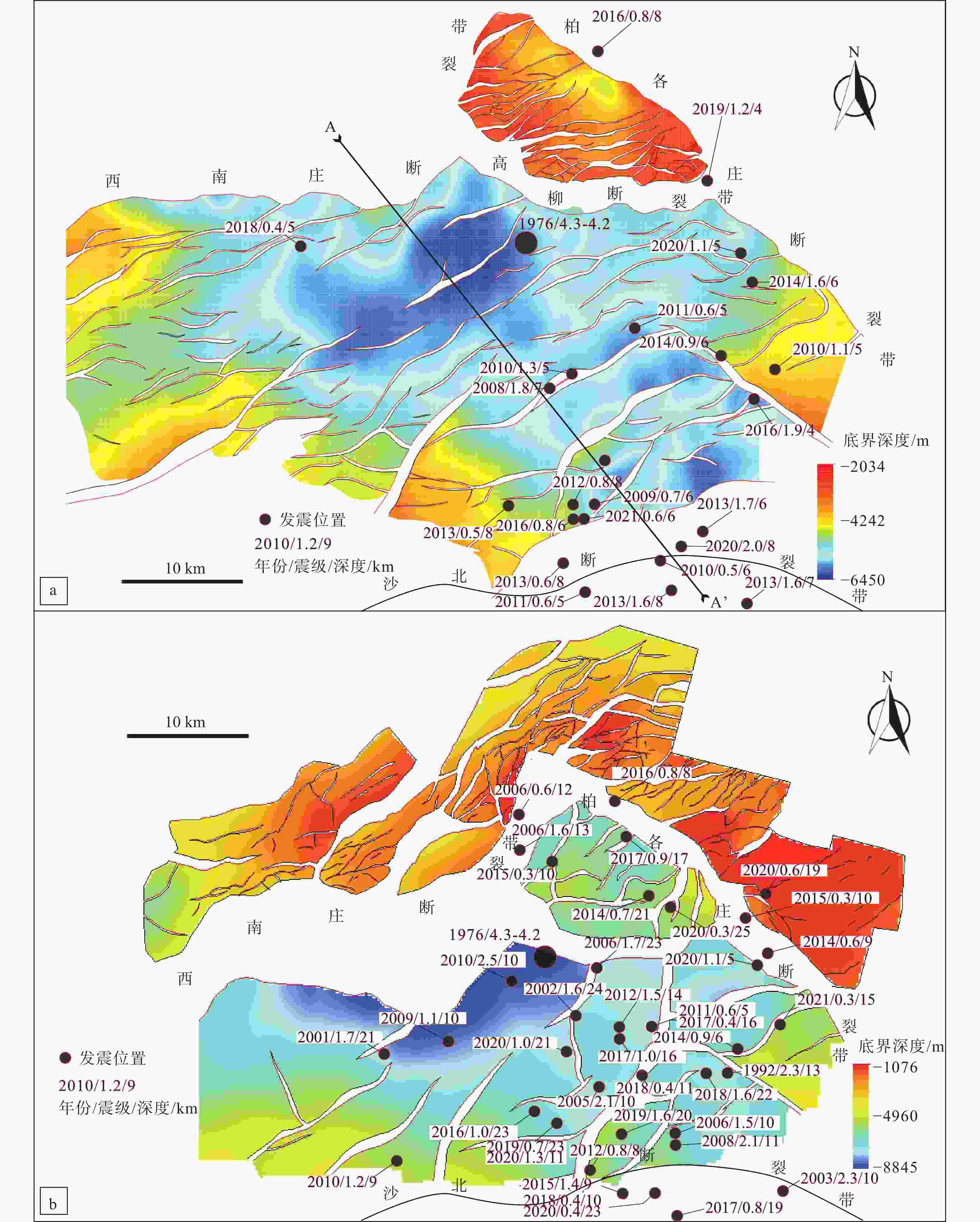
图 8 南堡凹陷底界构造与地震叠合图(图中地震数据来源与图1相同)
a—河街组三段一亚段底界构造与地震(5 km<震源深度≤8 km)叠合图; b—太古界顶面构造与地震(8 km<震源深度<12 km)叠合图
Figure 8. Earthquake hypocenter superimposed on maps of the boundary structures of strata in the Nanpu sag (seismic data from the same source as Fig. 1)
(a) Earthquake hypocenter (5 km < depth ≤ 8 km) superimposed on a map of the lower boundary structures of the first submember of the third member of the Paleogene Shahejie Formation ; (b) Earthquake hypocenter (8 km<depth<12 km) superimposed on a map of the surface boundary structures of the Archean strata
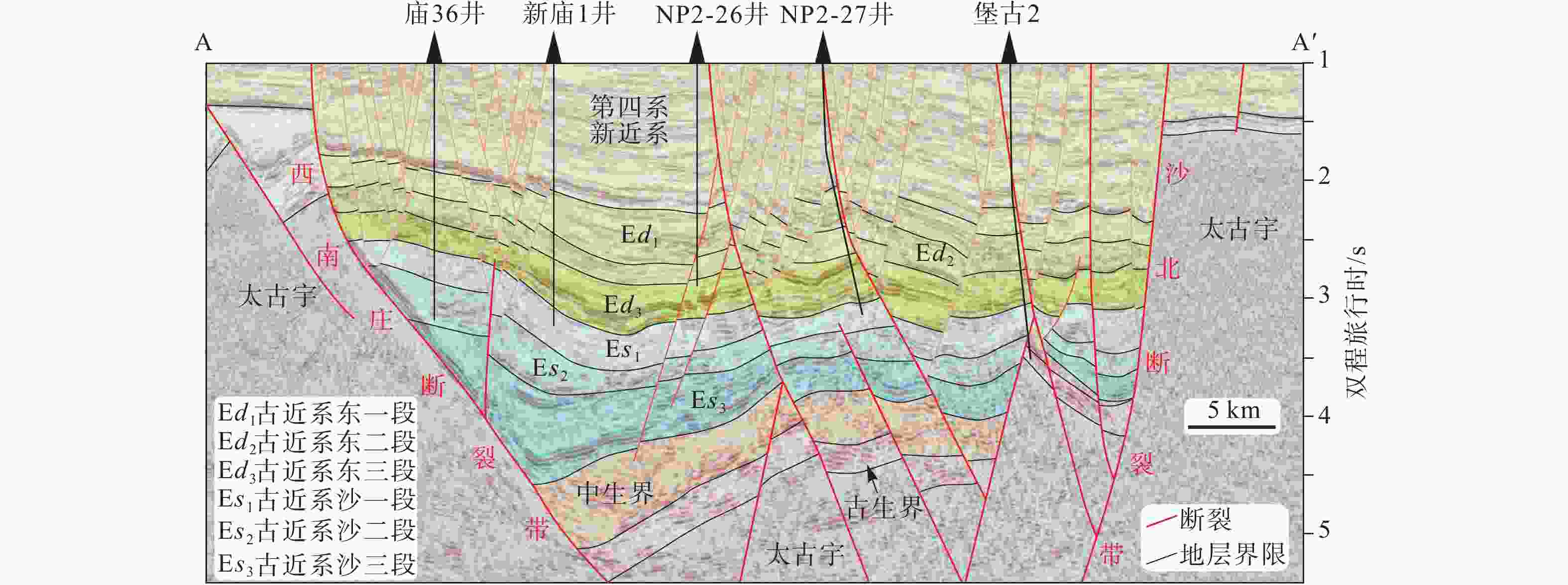
图 9 南堡凹陷地震剖面图(剖面位置见图8a;商琳等,2024)
Figure 9. The seismic profile of the Nanpu sag (Shang et al., 2024), the profile location is shown in Fig. 8a.
-
[1] CHEN Q X, 1992. An approach to assessment of regional crustal stability[J]. Quaternary Sciences, 12(4): 289-292. (in Chinese with English abstract [2] CHEN W P, NÁBELEK J, 1988. Seismogenic strike-slip faulting and the development of the North China basin[J]. Tectonics, 7(5): 975-989. doi: 10.1029/TC007i005p00975 [3] CHEN Y K, REN F, ZHANG C F, et al., 2004. Characteristics of Late Quaternary activity of the Haihe buried fault in Tianjin municipality[J]. Seismology and Geology, 26(1): 111-121. (in Chinese with English abstract [4] CHOI J H, EDWARDS P, KO K, et al., 2016. Definition and classification of fault damage zones: a review and a new methodological approach[J]. Earth-Science Reviews, 152: 70-87. doi: 10.1016/j.earscirev.2015.11.006 [5] COLLETTINI C, HOLDSWORTH R E, 2004. Fault zone weakening and character of slip along low-angle normal faults: insights from the Zuccale fault, Elba, Italy[J]. Journal of the Geological Society, 161(6): 1039-1051. doi: 10.1144/0016-764903-179 [6] DENG Q D, 2007. Map of active tectonics in China[M]. Beijing: Seismological Press. (in Chinese) [7] DU D, WANG G M, 2020. Evaluation of regional crustal stability in the joint area of Beijing, Tianjin and Hebei[J]. Geological Survey and Research, 43(3): 218-223. (in Chinese with English abstract [8] FENG C J, QI B S, WANG X S, et al., 2019. Study of fault activity risk in typical strong seismic regions in northern China by in-situ stress measurements and the influence on the Xiong’an New Area[J]. Earth Science Frontiers, 26(4): 170-190. (in Chinese with English abstract [9] GAO B, JIA K, ZHOU S Y, 2016. Research of locations and source parameters of historical earthquakes equal and greater than M5.0 from 1900 to 1970 in North China[J]. Chinese Journal of Geophysics, 59(11): 4089-4099. (in Chinese with English abstract [10] GAO G L, LIU W, LI C, et al., 2023. A calculation method for the storage capacity of UGS rebuilt from oil reservoirs[J]. Natural Gas Industry, 43(10): 132-140. (in Chinese with English abstract [11] HAN G M, WANG L, XIAO D Q, et al., 2021. Magmatic hydrothermal fluid genesis of zeolite in the Paleogene Kongdian formation of Zaoyuan oilfield, Bohai Bay Basin, China[J]. Petroleum Exploration and Development, 48(5): 1101-1112. doi: 10.1016/S1876-3804(21)60094-0 [12] HAO M, LI Y H, ZHUANG W Q, 2019. Crustal movement and strain distribution in east Asia revealed by GPS observations[J]. Scientific Reports, 9(1): 16797. doi: 10.1038/s41598-019-53306-y [13] HU H T, 2001. The theory and method of evaluation of regional crustal stability based on concept of “safe island”[J]. Journal of Geomechanics, 7(2): 97-103. (in Chinese with English abstract [14] HU W, ZHU G, SONG L H, et al., 2013. Analysis of Quaternary activity along the Bohai segment of the Tan-Lu fault zone[J]. Earth Science Frontiers, 20(4): 137-150. (in Chinese with English abstract [15] JING Y Q, LEI C, LIU K D, et al., 2023. Deposition environment and provenance of the Palaeogene Shahejie formation in Nanpu sag: evidences from trace and rare earth element geochemistry[J]. Bulletin of Geological Science and Technology, 42(1): 350-359. (in Chinese with English abstract [16] KIM Y S, PEACOCK D C P, SANDERSON D J, 2004. Fault damage zones[J]. Journal of Structural Geology, 26(3): 503-517. doi: 10.1016/j.jsg.2003.08.002 [17] LI X T, XU B, HUANG D C, et al. , 1987. Theory and method of regional crustal stability[M]. Beijing: Geological Publishing House. (in Chinese) [18] LIN X D, YUAN H Y, XU P, et al., 2017. Zonational characteristics of earthquake focal mechanism solutions in North China[J]. Chinese Journal of Geophysics, 60(12): 4589-4622. (in Chinese with English abstract [19] LIU B J, ZHANG X K, CHEN Y, et al., 2011. Research on crustal structure and active fault in the Sanhe-Pinggu earthquake (M8.0) zone based on single-fold deep seismic reflection and shallow seismic reflection profiling[J]. Chinese Journal of Geophysics, 54(5): 1251-1259. (in Chinese with English abstract [20] LIU L, SUN Y H, CHEN C, et al., 2022. Fault reactivation in No. 4 structural zone and its control on oil and gas accumulation in Nanpu sag, Bohai Bay Basin, China[J]. Petroleum Exploration and Development, 49(4): 824-836. doi: 10.1016/S1876-3804(22)60313-6 [21] MIN Z Q, WU G, JIANG Z X, et al. , 1995. Catalogue of Chinese historic strong earthquakes from BC 2300 to AD 1911[M]. Beijing: Seismological Press. (in Chinese) [22] QIAO X, ZHOU Y, 2021. Geodetic imaging of shallow creep along the Xianshuihe fault and its frictional properties[J]. Earth and Planetary Science Letters, 567: 117001. doi: 10.1016/j.jpgl.2021.117001 [23] RAN R K, WANG J B, PENG S Z, et al., 1995. Palaeoeakthquake traces along the southern boundary fault of Xuanhua Basin, Hebei Province[J]. Seismology and Geology, 17(1): 44-46. (in Chinese with English abstract [24] RAN Y K, CHEN L C, XU X W, 2001. Quantitative data about active tectonics and possible locations of strong earthquakes in the future in northwest Beijing[J]. Acta Seismologica Sinica, 23(5): 502-513. (in Chinese with English abstract [25] SHANG L, GAO G L, YAO D D, et al. , 2024. Characteristics of the fault system in Nanpu sag and its Cenozoic evolution[J/OL]. Acta Geologica Sinica, DOI: 10.19762/j. cnki. dizhixuebao. 2024122. DOI: 10.19762/j. cnki. dizhixuebao. 2024122 https://kns.cnki.net/kcms2/article/abstract?v=i12nDYUbXpK0POlTEro-fT0ho3vF020oNuGpHvhCVsKP9GwAuHzLA8LNZQg7Jdh5ytlH1BB9tvBNx0fcsdJXZX-Ku9l4arTY_14mNJfnRQCwJ71cfJX5hEFc2x2gtuSbyJcED84bMF3cZLX-_Vbv2fhY7-xgA1NkyYs97o0iYGY2XzI7NM9DlpDog_1SpkJQVKq3q0KQks26o31f (in Chinese with English abstract [26] SHU P, XU X W, FENG S Y, et al., 2023. Sedimentary and tectonic evolution of the Banquan pull-apart basin and implications for Late Cenozoic dextral strike-slip movement of the Tanlu Fault Zone[J]. Science China Earth Sciences, 66(4): 797-820. doi: 10.1007/s11430-022-1028-5 [27] SU P, HE H L, TAN X B, et al., 2021. Initiation and evolution of the Shanxi rift system in North China: evidence from low-temperature thermochronology in a plate reconstruction framework[J]. Tectonics, 40(3): e2020TC006298. doi: 10.1029/2020TC006298 [28] SUO Y H, LI S Z, LIU X, et al., 2013. Structural characteristics of NWW-trending active fault zones in East China: a case study of the Zhangjiakou-Penglai fault zone[J]. Acta Petrologica Sinica, 29(3): 953-966. (in Chinese with English abstract [29] TAPPONNIER P, PELTZER G, LE DAIN A Y, et al., 1982. Propagating extrusion tectonics in Asia: new insights from simple experiments with Plasticine[J]. Geology, 10(12): 611-616. doi: 10.1130/0091-7613(1982)10<611:PETIAN>2.0.CO;2 [30] TONG H M, FAN C W, MENG L J, et al., 2018. Manifestation and origin mechanism of the fault system complexity in rift basins in eastern-Southern China: case study of the Nanpu and Weixinan sags[J]. Acta Geologica Sinica, 92(9): 1753-1765. (in Chinese with English abstract [31] WALDHAUSER F, ELLSWORTH W L, 2000. A double-difference earthquake location algorithm: method and application to the northern Hayward fault, California[J]. Bulletin of the Seismological Society of America, 90(6): 1353-1368. doi: 10.1785/0120000006 [32] WAN T, JIANG Y L, DONG Y X, et al., 2012. Relationship between fault activity and hydrocarbon accumulation and enrichment in Nanpu depression[J]. Journal of China University of Petroleum, 36(2): 60-67. (in Chinese with English abstract [33] WANG H Q, TAN C X, FENG C J, et al., 2022. Activity structure and crustal stability in Beijing-Tianjin-Hebei collaborative development zone[J]. Geological Bulletin of China, 41(8): 1322-1341. (in Chinese with English abstract [34] WANG H R, FU G, SUN T W, 2016. Recovery of oil-source fault ancient transfer zone and its favorable conditions to oil-gas transportation: taking fault F10 in No. 2 structure of Nanpu sag as an example[J]. Natural Gas Geoscience, 27(10): 1848-1854. (in Chinese with English abstract [35] WANG J W, DU J X, ZHANG Y C, et al., 2019. The geological conditions, resource potential and exploration direction in Nanpu sag of Jidong depression, Bohai Bay Basin[J]. Marine Origin Petroleum Geology, 24(3): 21-28. (in Chinese with English abstract [36] WANG M, SHEN Z K, 2019. Present‐day crustal deformation of continental China derived from GPS and its tectonic implications[J]. Journal of Geophysical Research: Solid Earth, 125(2): e2019JB018774. [37] WANG Q J, ZHANG Y, LIU X, 2003. Geological performance of Dazhangtuo underground gas storage and its operation efficiency analysis[J]. Natural Gas Industry, 23(2): 89-92. (in Chinese with English abstract [38] WANG X, ZHOU Y, CHEN T, et al., 2021. Analysis of the Tangshan M5.1 earthquake on July 12, 2020[J]. China Earthquake Engineering Journal, 43(6): 1280-1287. (in Chinese with English abstract [39] WU Z H, ZHOU C J, TAN C X, et al., 2016. The active tectonics and regional crustal stability features in the area of Yangtze River economic belt[J]. Journal of Geomechanics, 22(3): 379-411. (in Chinese with English abstract [40] XU J, NIU L F, WANG C H, et al., 1996. Tangshan-Hejian-Cixian newly-generated seismotectonic zone[J]. Seismology and Geology, 18(3): 193-198. (in Chinese with English abstract [41] XU J, SONG C Q, CHU Q Z, 1998. Preliminary study on the seismotectonic characters of the Zhangjiakou-Penglai fault zone[J]. Seismology and Geology, 20(2): 146-154. (in Chinese with English abstract [42] XU X W, MA X Y, 1992. Geodynamics of the Shanxi rift system, China[J]. Tectonophysics, 208(1-3): 325-340. doi: 10.1016/0040-1951(92)90353-8 [43] YAN X B, LI W Q, YOU W Z, et al., 2023. Study on creep evidence and deep deformation mechanism of the Chafangkou segment of the northern Piedmont fault of Xizhoushan[J]. Earthquake, 43(3): 91-101. (in Chinese with English abstract [44] YANG S H, HE S M, YANG B, et al., 2003. The operation practice and evaluation for Dazhangtuo underground gas storage[J]. Natural Gas Geoscience, 14(5): 425-428. (in Chinese with English abstract [45] YANG Y H, GAO G L, WANG F, et al., 2022. Layered in-situ stress measurement method for perforated interval of Nanpu Gas Storage, Jidong Oilfield[J]. Oil & Gas Storage and Transportation, 41(9): 1029-1035. (in Chinese with English abstract [46] YI M C, 2003. Neotectonic activity and regional crustal stability[M]. Beijing: Seismological Press. (in Chinese) [47] YIN A, YU X J, SHEN Z K, et al., 2015. A possible seismic gap and high earthquake hazard in the North China Basin[J]. Geology, 43(1): 19-22. doi: 10.1130/G35986.1 [48] YOU H C, SHAO C R, YANG Q Y, et al., 2008. Some active evidences in Late Quaternary of Zhangjiakou Fault[J]. Technology for Earthquake Disaster Prevention, 3(4): 474-477. (in Chinese with English abstract [49] ZHAN R, ZHU G, 2012. Cenozoic activity methods and evolution of the Tan-Lu fault zone in Bohai Bay: evidence from the Qingdong sag[J]. Chinese Journal of Geology, 47(4): 1130-1150. (in Chinese with English abstract [50] ZHANG G W, JI Y, GUO H, et al., 2022. Complex fault geometry of the 1976 Ms 7.8 Tangshan earthquake source region in North China[J]. Tectonophysics, 845: 229642. doi: 10.1016/j.tecto.2022.229642 [51] ZHANG H Z, DIAO G L, CHEN Q F, et al., 2008. Focal mechanism analysis of the recent earthquakes in Tangshan seismic region of M7.6 in 1976[J]. Journal of Seismological Research, 31(1): 1-6. (in Chinese with English abstract [52] ZHANG Q, TEYSSIER C, DUNLAP J, et al. , 2007. Oblique collision between north and South China recorded in Zhangbaling and Fucha Shan (Dabie-Sulu transfer zone)[M]//ROESKE A M, TILL A B, FOSTER D A, et al. Exhumation associated with continental strike-slip fault system. Boulder: Geological Society of America: 167-206. [53] ZHANG S X, YANG W M, MENG H J, et al., 2018. Regional crustal stability evaluation in Beijing-Zhangjiakou area[J]. Journal of Geomechanics, 24(1): 70-77. (in Chinese with English abstract [54] ZHANG Y G, ZHENG W J, WANG Y J, et al., 2018. Contemporary deformation of the North China plain from global positioning system data[J]. Geophysical Research Letters, 45(4): 1851-1859. doi: 10.1002/2017GL076599 [55] ZHANG Y Y, GAO Y, SHI Y T, et al., 2015. Crustal thickness and Poisson’s ratio beneath Zhangjiakou-Bohai seismic active belt and its neighboring regions[J]. Acta Seismologica Sinica, 37(4): 541-553. (in Chinese with English abstract [56] ZHOU H M, WEI Z W, CAO Z H, et al., 2000. Relatioship between formation, evolution and hydrocarbon in Nanpu sag[J]. Oil & Gas Geology, 21(4): 345-349. (in Chinese with English abstract [57] ZHU G, LIU G S, NIU M L, et al., 2009. Syn-collisional transform faulting of the Tan-Lu fault zone, East China[J]. International Journal of Earth Sciences, 98(1): 135-155. doi: 10.1007/s00531-007-0225-8 [58] ZHU G, LIU C, GU C C, et al., 2018. Oceanic plate subduction history in the western Pacific Ocean: constraint from Late Mesozoic evolution of the Tan-Lu fault zone[J]. Science China Earth Sciences, 61(4): 386-405. doi: 10.1007/s11430-017-9136-4 [59] 陈庆宣,1992. 探索区域地壳稳定性评价途径[J]. 第四纪研究,12(4):289-292. doi: 10.3321/j.issn:1001-7410.1992.04.001 [60] 陈宇坤,任峰,张翠芬,等,2004. 天津海河隐伏断裂的晚第四纪活动特征研究[J]. 地震地质,26(1):111-121. doi: 10.3969/j.issn.0253-4967.2004.01.011 [61] 邓起东,2007. 中国活动构造图[M]. 北京:地震出版社. [62] 杜东,王国明,2020. 京津冀结合部区域地壳稳定性评价[J]. 地质调查与研究,43(3):218-223. [63] 丰成君,戚帮申,王晓山,等,2019. 基于原地应力实测数据探讨华北典型强震区断裂活动危险性及其对雄安新区的影响[J]. 地学前缘,26(4):170-190. [64] 高彬,贾科,周仕勇,2016. 华北地区1900-1970年5级以上地震发震位置与震源机制研究[J]. 地球物理学报,59(11):4089-4099. [65] 高广亮,刘伟,李聪,等,2023. 油藏改建地下储气库库容量计算方法[J]. 天然气工业,43(10):132-140. [66] 胡海涛,2001. 区域地壳稳定性评价的“安全岛”理论及方法[J]. 地质力学学报,7(2):97-103. [67] 胡惟,朱光,宋利宏,等,2013. 郯庐断裂带渤海段第四纪活动规律探讨[J]. 地学前缘,20(4):137-150. [68] 静禹钱,雷闯,刘克栋,等,2023. 南堡凹陷古近系沙河街组沉积环境和物源:来自微量和稀土元素地球化学的证据[J]. 地质科技通报,42(1):350-359. [69] 李兴唐,许兵,黄鼎成,等,1987. 区域地壳稳定性研究理论与方法[M]. 北京:地质出版社. [70] 林向东,袁怀玉,徐平,等,2017. 华北地区地震震源机制分区特征[J]. 地球物理学报,60(12):4589-4622. [71] 刘保金,张先康,陈颙,等,2011. 三河-平谷8.0级地震区地壳结构和活动断裂研究:利用单次覆盖深反射和浅层地震剖面[J]. 地球物理学报,54(5):1251-1259. [72] 闵子群,吴戈,江在雄,等,1995. 中国历史强震目录(公元前23世纪—公元191年)[M]. 北京:地震出版社. [73] 冉勇康,王景钵,彭斯震,等,1995. 河北宣化盆地南缘断裂的古地震遗迹[J]. 地震地质,17(1):44-46. [74] 冉勇康,陈立春,徐锡伟,2001. 北京西北活动构造定量资料与未来强震地点的讨论[J]. 地震学报,23(5):502-513. [75] 商琳,高广亮,姚丹丹,等,2024. 南堡凹陷断裂系统特征及其新生代构造演化[J/OL]. 地质学报. DOI:10.19762/j. cnki. dizhixuebao. 2024122 https://kns.cnki.net/kcms2/article/abstract?v=i12nDYUbXpK0POlTEro-fT0ho3vF020oNuGpHvhCVsKP9GwAuHzLA8LNZQg7Jdh5ytlH1BB9tvBNx0fcsdJXZX-Ku9l4arTY_14mNJfnRQCwJ71cfJX5hEFc2x2gtuSbyJcED84bMF3cZLX-_Vbv2fhY7-xgA1NkyYs97o0iYGY2XzI7NM9DlpDog_1SpkJQVKq3q0KQks26o31f [76] 索艳慧,李三忠,刘鑫,等,2013. 中国东部NWW向活动断裂带构造特征:以张家口-蓬莱断裂带为例[J]. 岩石学报,29(3):953-966. [77] 童亨茂,范彩伟,孟令箭,等,2018. 中国东-南部裂陷盆地断裂系统复杂性的表现形式及成因机制:以南堡凹陷和涠西南凹陷为例[J]. 地质学报,92(9):1753-1765. [78] 万涛,蒋有录,董月霞,等,2012. 南堡凹陷断层活动与油气成藏和富集的关系[J]. 中国石油大学学报(自然科学版),36(2):60-67. [79] 王浩然,付广,孙同文,2016. 油源断裂古转换带恢复及其输导油气的有利条件:以南堡凹陷2号构造F10断裂为例[J]. 天然气地球科学,27(10):1848-1854. doi: 10.11764/j.issn.1672-1926.2016.10.1848 [80] 王惠卿,谭成轩,丰成君,等,2022. 京津冀协同发展区活动构造与地壳稳定性[J]. 地质通报,41(8):1322-1341. [81] 王建伟,杜景霞,张永超,等,2019. 南堡凹陷石油地质条件、资源潜力及勘探方向[J]. 海相油气地质,24(3):21-28. doi: 10.3969/j.issn.1672-9854.2019.03.003 [82] 王起京,张余,刘旭,2003. 大张坨地下储气库地质动态及运行效果分析[J]. 天然气工业,23(2):89-93. doi: 10.3321/j.issn:1000-0976.2003.02.029 [83] 王想,周依,陈婷,等,2021. 2020年7月12日唐山5.1级地震分析[J]. 地震工程学报,43(6):1280-1287. [84] 吴中海,周春景,谭成轩,等,2016. 长江经济带地区活动构造与区域地壳稳定性基本特征[J]. 地质力学学报,22(3):379-411. doi: 10.3969/j.issn.1006-6616.2016.03.001 [85] 徐杰,牛娈芳,王春华,等,1996. 唐山-河间-磁县新生地震构造带[J]. 地震地质,18(3):193-198. [86] 徐杰,宋长青,楚全芝,1998. 张家口-蓬莱断裂带地震构造特征的初步探讨[J]. 地震地质,20(2):146-154. [87] 闫小兵,李文巧,由文智,等,2023. 系舟山北麓断裂茶房口段蠕滑证据及深部变形机制研究[J]. 地震,43(3):91-101. [88] 杨树合,何书梅,杨波,等,2003. 大张坨地下储气库运行实践与评价[J]. 天然气地球科学,14(5):425-428. doi: 10.3969/j.issn.1672-1926.2003.05.020 [89] 杨跃辉,高广亮,王芳,等,2022. 冀东南堡储气库射孔段分层地应力测量方法[J]. 油气储运,41(9):1029-1035. [90] 易明初,2003. 新构造活动与区域地壳稳定性[M]. 北京:地震出版社. [91] 尤惠川,邵翠茹,杨歧焱,等,2008. 张家口断裂发现第四纪晚期活动证据[J]. 震灾防御技术,3(4):474-477. doi: 10.3969/j.issn.1673-5722.2008.04.018 [92] 詹润,朱光,2012. 渤海海域郯庐断裂带新生代活动方式与演化规律:以青东凹陷为例[J]. 地质科学,47(4):1130-1150. doi: 10.3969/j.issn.0563-5020.2012.04.014 [93] 张宏志,刁桂苓,陈祺福,等,2008. 1976年唐山7.8级地震震区现今地震震源机制分析[J]. 地震研究,31(1):1-6. [94] 张树轩,杨为民,孟华君,等,2018. 京张地区区域地壳稳定性评价[J]. 地质力学学报,24(1):70-77. doi: 10.12090/j.issn.1006-6616.2018.24.01.008 [95] 张莹莹,高原,石玉涛,等,2015. 张家口-渤海地震活动带及其邻区的地壳厚度与泊松比分布[J]. 地震学报,37(4):541-553. [96] 周海民,魏忠文,曹中宏,等,2000. 南堡凹陷的形成演化与油气的关系[J]. 石油与天然气地质,21(4):345-349. doi: 10.11743/ogg20000415 -

 下载:
下载:


计量
- 文章访问数: 1681
- HTML全文浏览量: 266
- PDF下载量: 41
- 被引次数: 0
