

Geomorphic features of the Menyuan basin in the Qilian Mountains and its tectonic significance
-
摘要: 祁连山位于青藏高原东北部边缘,是青藏高原向北东方向挤压扩展的前缘部位,其典型流域地貌特征记录了该地区的新构造活动和地貌发育演化过程。门源盆地是位于祁连山中段内部的一个典型的山间盆地,其发育模式和地貌特征与构造活动有着直接的关系。为探究门源盆地北缘断裂及其不同区段构造活动性的差异及其成因,文中基于30m分辨率数字高程模型(DEM)数据,采用ArcGIS空间分析技术,提取了盆地北缘横穿山体的15条河道的面积−高程积分(HI)和积分曲线(HC),再利用克里金插值法得到HI值在盆地空间上的分布特征。结果表明,以门源盆地北缘断裂走向转折处——老虎沟为界,其西侧河道流域的HI值整体较高,东侧HI值普遍较低;结合野外活动构造调查结果,发现老虎沟东侧断裂已经挤压扩展到盆地内部,并发育一系列的活动逆断层−褶皱带,由此推断断裂走向变化及北东向断裂导致了流域HI值的分布差异。同时,盆地内部青石嘴镇附近出现一处HI高值异常,结合大地电磁探测结果推测盆地内部存在一条隐伏断层。另外,多数河道在主断裂通过上游一定位置时出现了河长坡降指数(SL)峰值波动,说明SL波动位置与断裂通过河道位置具有良好的相关性,即构造活动可以对SL产生显著影响;而处于岩性变化位置附近的波动异常,可能表明局部河段的岩性变化对SL也有一定影响。综合分析表明,门源盆地北缘东、西段的地貌发育具有显著差异,主要受该区域活动构造即门源盆地北缘断裂的控制和影响,上述地貌参数是较为敏感的构造活动性评价指标。Abstract: The Qilian Mountains are situated on the northeastern margin of the Tibetan Plateau and serve as the leading edge of the plateau's northeastward expansion. The Menyuan Basin, characterized by typical basin landforms, provides valuable insights into the region's neotectonic activity and geomorphic evolution. As a representative mountain basin located in the central part of the Qilian Mountains, the Menyuan Basin's development pattern and geomorphic features are closely linked to tectonic activity. This study aims to investigate the variations in tectonic activity and their underlying causes along the north margin fault and different zones of the Menyuan Basin. To achieve this, 30 m resolution digital elevation model (DEM) data and ArcGIS spatial analysis technology were employed to extract the hypsometric integral (HI) and hypsometric integral curve (HC) of 15 rivers that traverse the northern edge of the basin. Subsequently, kriging interpolation was utilized to obtain the spatial distribution characteristics of HI within the basin. The findings reveal that HI values generally exhibit higher values on the western side and lower values on the eastern side of the Menyuan Basin, with the turning point (Laohugou) of the northern fault at the Menyuan Basin serving as the boundary. By combining the distribution of HI with field investigation results of active structures, it is observed that the eastern fault has extended into the basin's interior, giving rise to a series of active reverse fault–fold zones. This phenomenon may be attributed to changes in fault trends and the presence of northeastward faults. Additionally, a high HI anomaly is detected near Qingshizui Town in the basin's interior. Based on previous electromagnetic detection results, it is inferred that a buried fault exists within the basin. Furthermore, the study demonstrates that most rivers exhibit peak fluctuations in the stream length–gradient index (SL) at a specific position upstream of the main fault, indicating a strong correlation between the location of SL fluctuations and the position of the fault intersecting the river. In other words, tectonic activity can exert a significant influence on SL. Abnormal fluctuations near lithological transitions may suggest that local changes in lithology also impact the stream length-gradient index. The comprehensive analysis underscores the substantial differences in geomorphic development between the eastern and western sections of the northern edge of the Menyuan Basin, primarily controlled and influenced by the active structures in this region. Moreover, the aforementioned geomorphic parameters serve as sensitive indicators for evaluating tectonic activity.
-
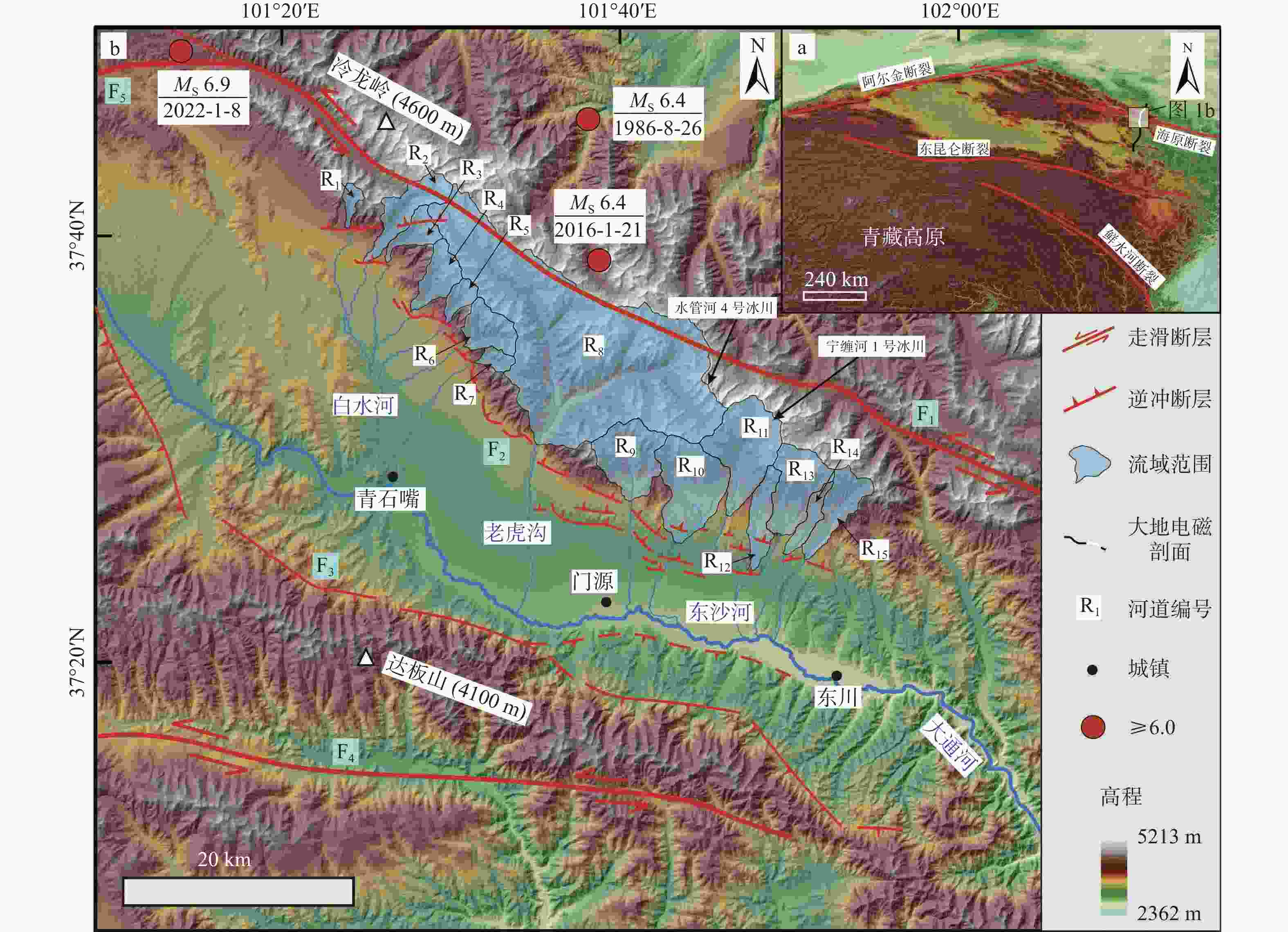
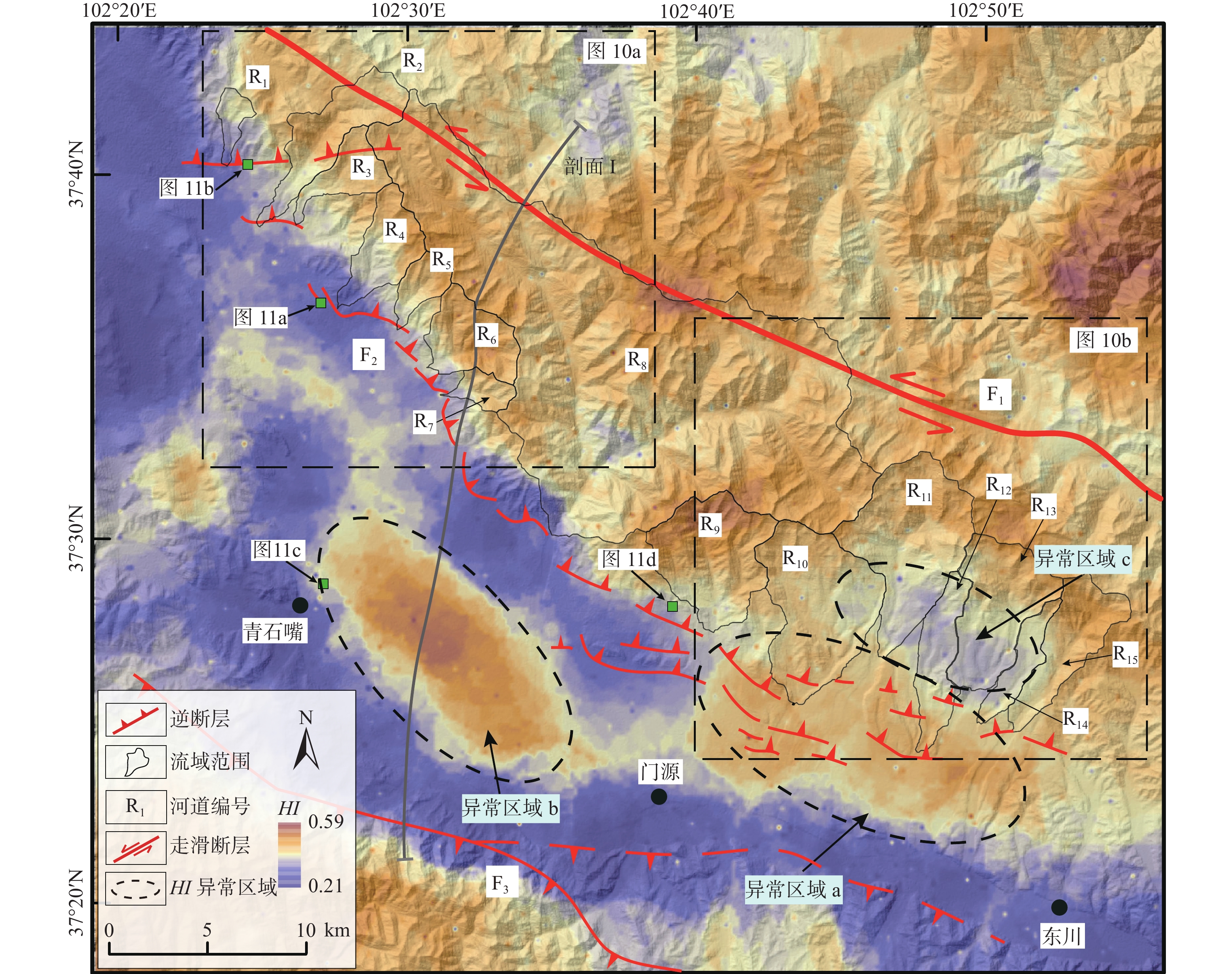
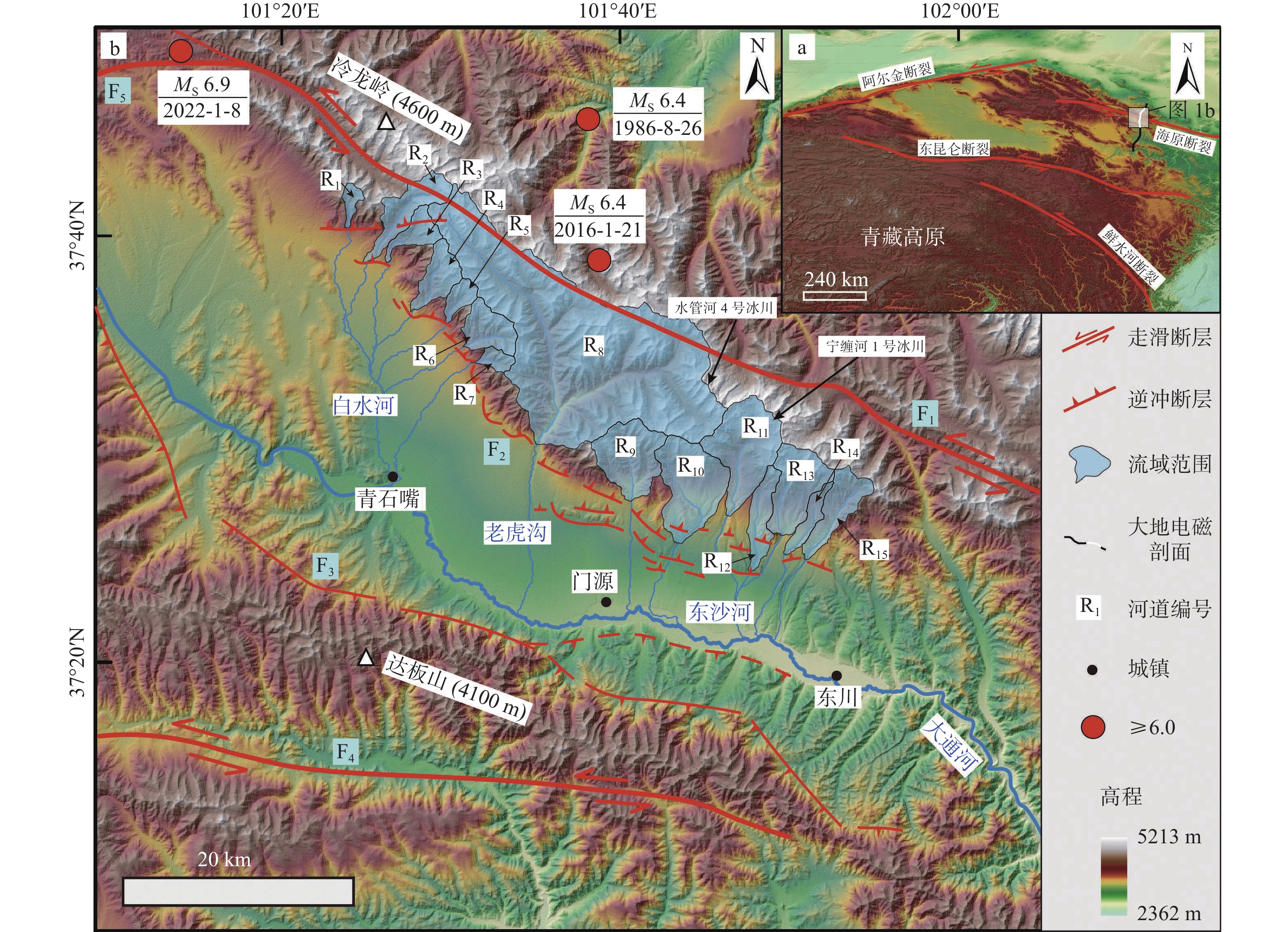
图 1 门源盆地构造背景图
F1—冷龙岭断裂;F2—门源盆地北缘断裂;F3—门源盆地南缘断裂;F4—达板山断裂;F5—托勒山北缘断裂
Figure 1. Geological background map of the Menyuan basin
F1–Lenglongling fault; F2–North margin fault of the Menyuan basin; F3–South margin fault of the Menyuan basin; F4–Dabanshan fault; F5–North margin fault of Tuoleshan

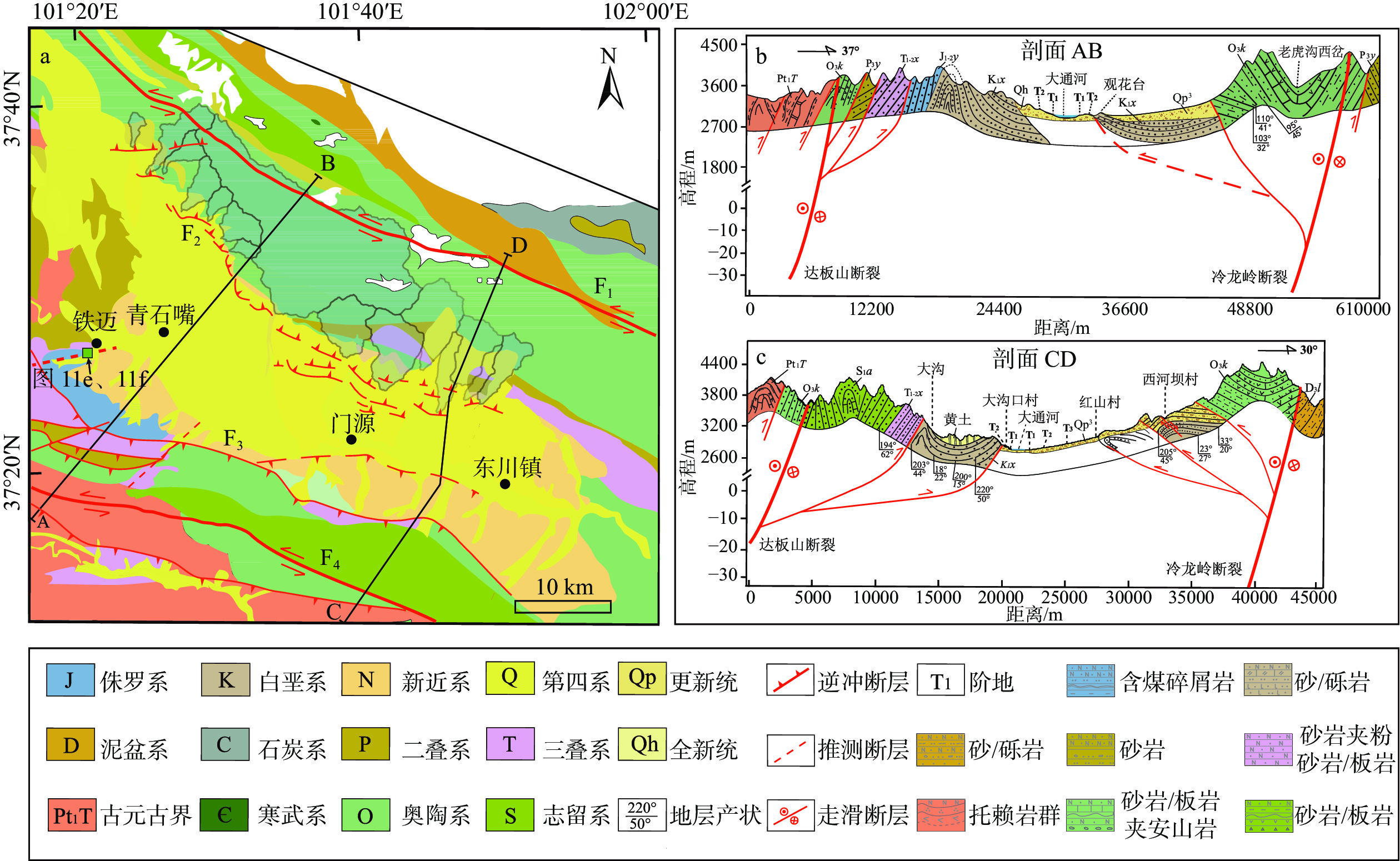
图 2 门源盆地地质图及穿盆剖面
Pt1T—托赖岩群;O3k—扣门子组;S1a—肮脏沟组;D3l—老君山组;P3y—窑沟组;T1-2x—西大沟组;J1-2y—窑街组;K1x—下沟组;F1—冷龙岭断裂;F2—门源盆地北缘断裂;F3—门源盆地南缘断裂;F4—达板山断裂a—研究区地质图(据左群超等,2018;青海省1∶250000门源回族自治县幅建造构造图修改);b—地质剖面图
Figure 2. Geological map of the Menyuan basin and cross-basin section (Geological map modified from Zuo et al., 2018; 1∶250000 Structural Map of Menyuan County, Qinghai Province)
(a) Geological map of the study area; (b) Geologic profile of the study areaPt1T–Tuolai Group; O3k–Koumenzi Formation; S1a –Angzanggou Formation; D3l–Laojunshan Formation; P3y–Yaogou Formation; T1-2x – Xidagou Formation; J1-2y – Yaojie Formation; K1x–Xiagou Formation F1– Lenglongling Fault; F2–North Margin Fault of Menyuan Basin; F3–South Margin Fault of Menyuan Basin; F4–Dabanshan Fault
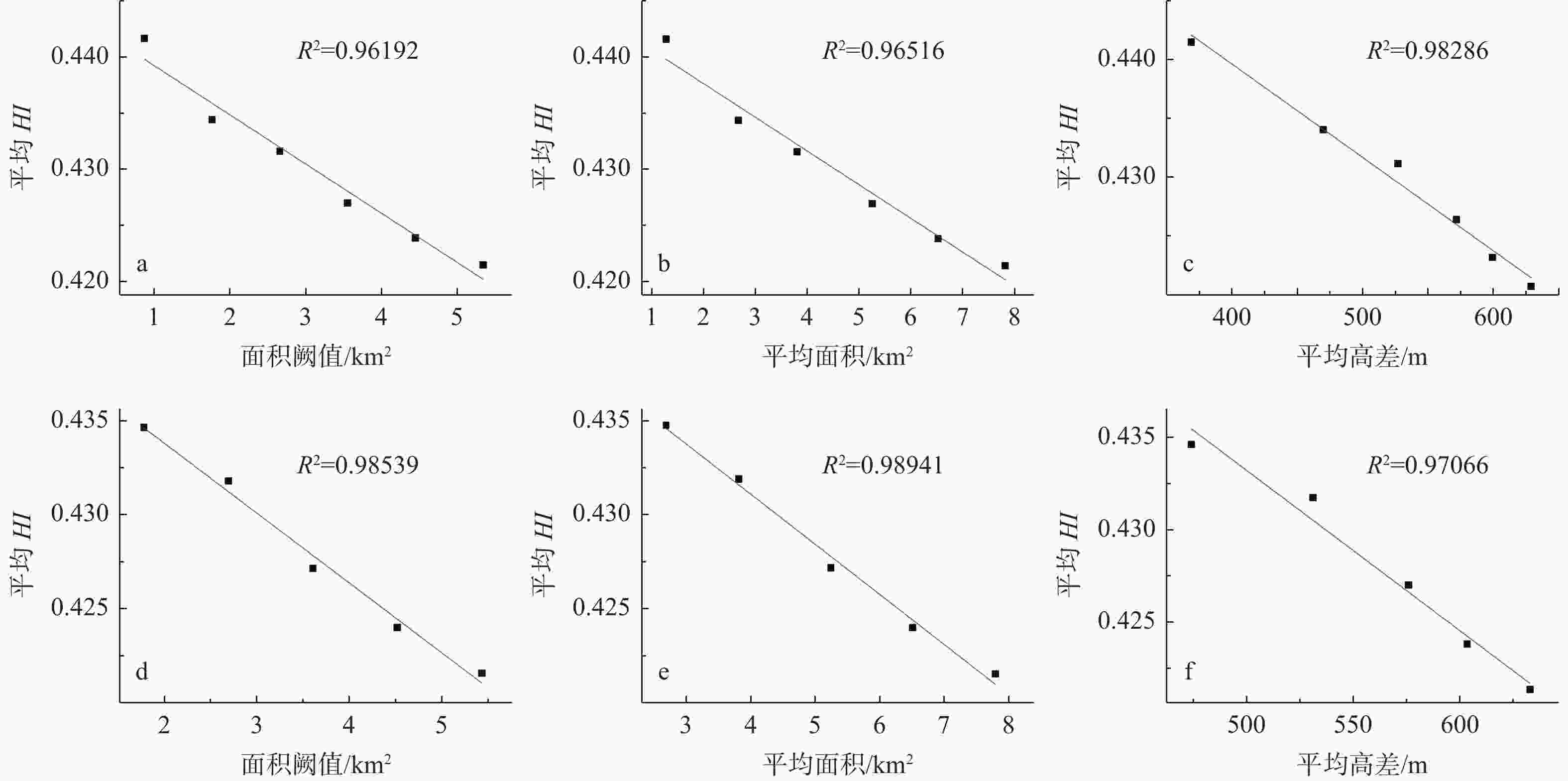
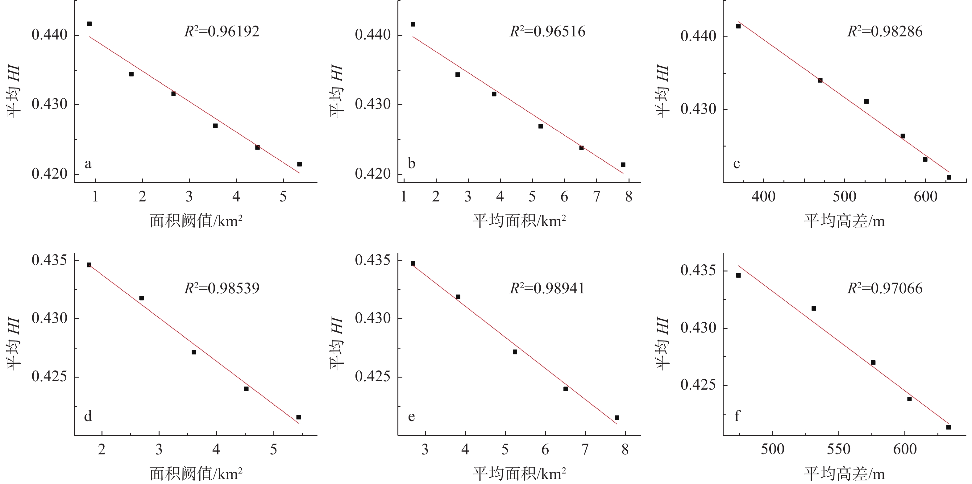
图 3 研究区平均HI值与面积阈值、平均面积、平均高差的相关关系图
a—平均HI值和面积阈值;b—平均HI值和平均面积;c—平均HI值和平均高差;d—调整后的平均HI值和面积阈值;e—调整后的平均值HI和平均面积;f—调整后的平均HI值和平均高差
Figure 3. The correlation graph between the average HI value in the study area and the area threshold, the average area and the average altitude difference
(a) Average HI value and area threshold; (b) Average HI value and average area; (c) Average HI value and average altitude difference; (d) Adjusted average HI value and area threshold; (e) Adjusted average HI value and average area; (f) Adjusted average HI value and average altitude difference

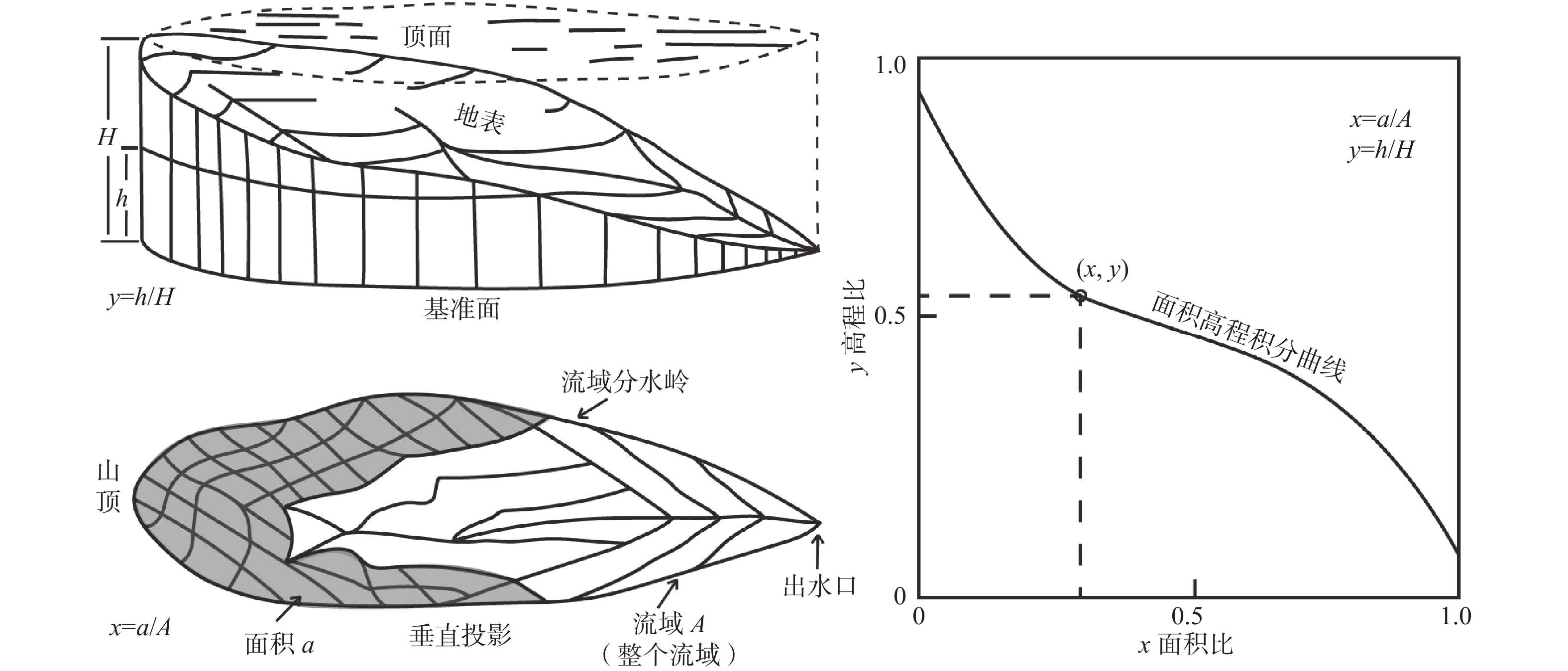
图 4 面积−高程积分示意图(据Strahler,1952修改)
h—流域内选定一点高程与出水口高差;H—河道河头与出水口高差;a—流域内选定一点对应的流域面积;A—整个流域的面积
Figure 4. Area–elevation integration diagram(Modified from Strahler, 1952)
h–Elevation difference between a selected point within the watershed and the outlet; H–Elevation difference between the riverhead and the outlet; a–Watershed area corresponding to a selected point within the watershed; A– Total area of the entire watershed

图 5 SL与Hack剖面示意图(据Hack, 1973修改)
图c、d中黑色虚线代表未受构造作用的Hack剖面形态与河道剖面形态,分别对应图a、b黑色实线;c、d中灰色实线与黑色实线代表随着构造作用Hack形态与河道剖面形态变化过程;图e中Ⅰ、Ⅱ对应不同阶段河道受到构造作用后的SL曲线形态,红色阶梯状曲线表示不同阶段的SL值H—河道高程;L—河道距离a—未受构造扰动的Hack剖面;b—未受构造扰动的河流纵剖面;c—受构造抬升的Hack剖面;d—受构造抬升的河流纵剖面;e—SL与Hack剖面叠图
Figure 5. SL and Hack profile schematic(Modified from Hack, 1973)
(a) Hack profile without tectonic disturbance; (b) undisturbed river profile; (c) Hack profile uplifted by tectonics; (d) Tectonically uplifted river profile; (e) SL and Hack profile overlay H–Stream height; L–Stream lengthIn figures c and d, the black dashed lines represent the unaltered morphology of the Hack profile and river channel profile, corresponding to the black solid lines in figures a and b. The gray solid lines and black solid lines in figures c and d represent the evolution of the Hack morphology and river channel profile with tectonic influences. In figure e, I and II correspond to the SL curve forms of the river channel at different stages after being affected by tectonic forces, where the red stepped curve represents SL values at different stages.
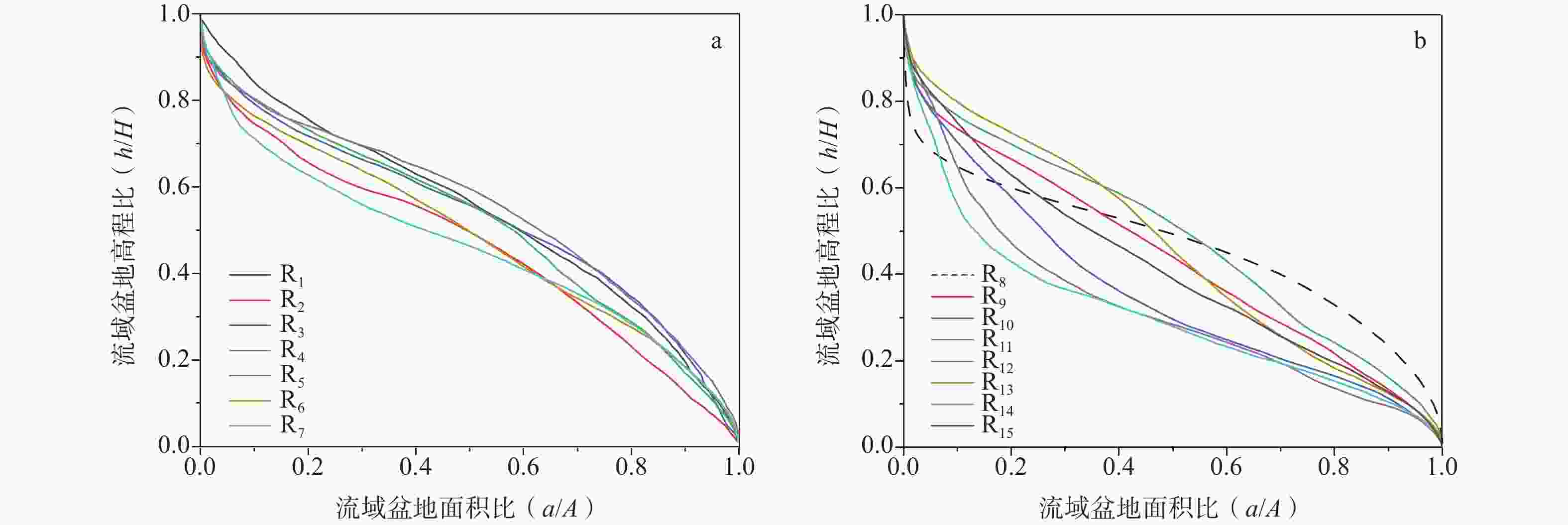
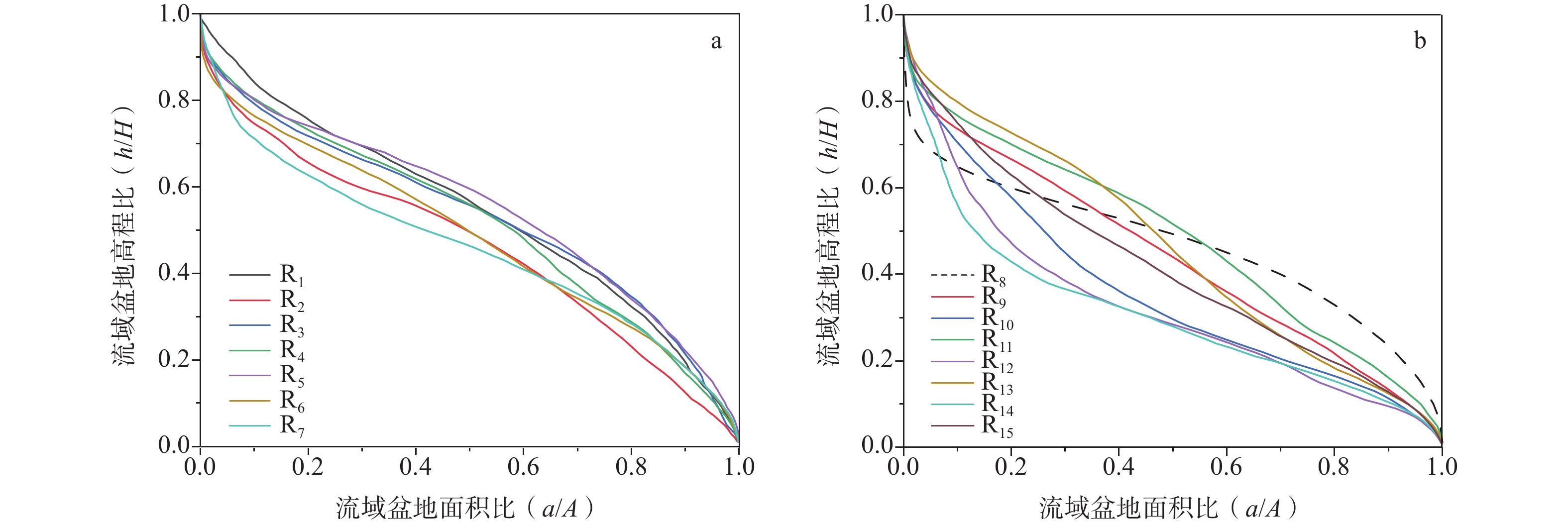
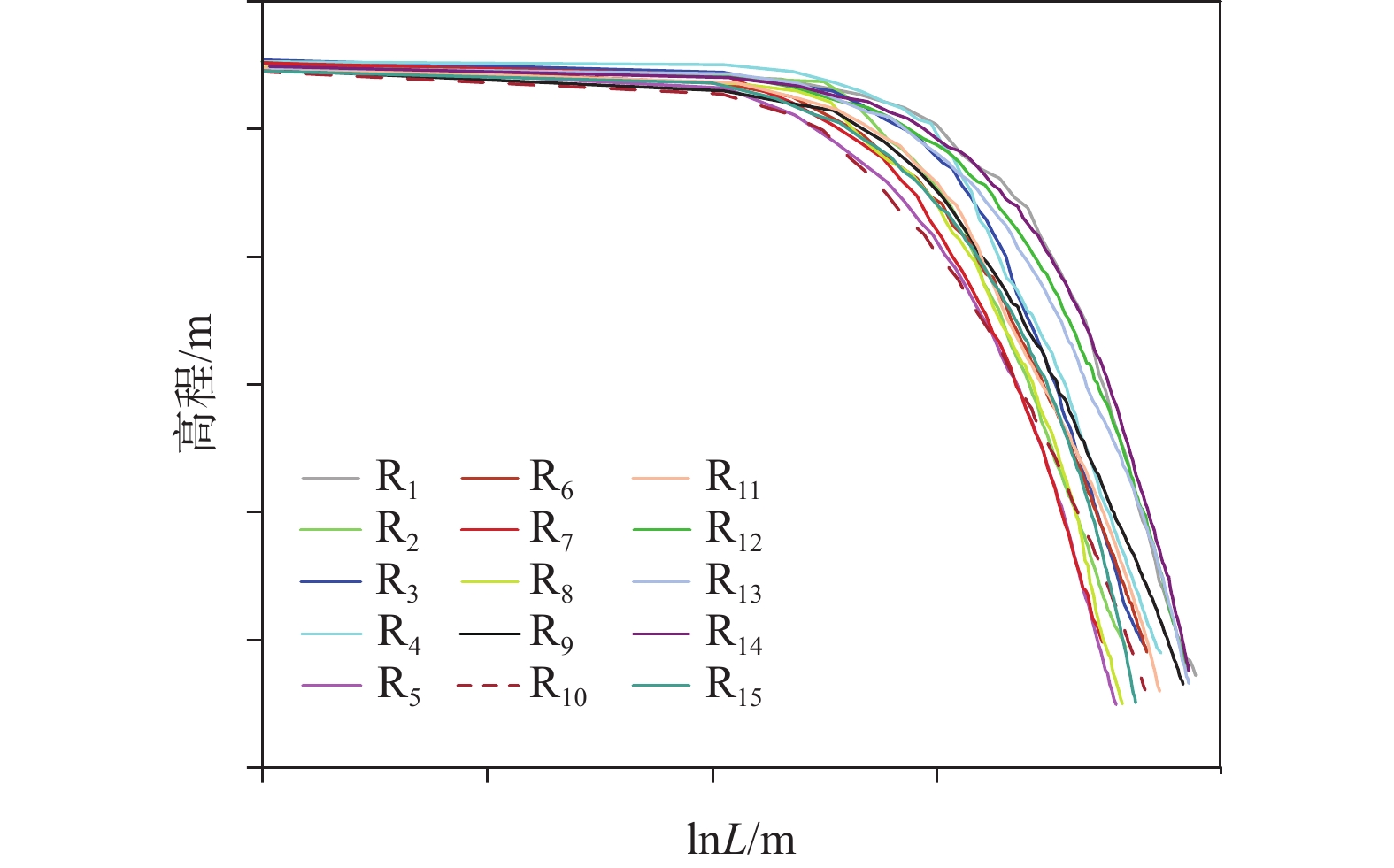
图 6 流域的HC曲线特征
a—西侧河道R1—R7的HC曲线;b—东侧河道R1—R8的HC曲线
Figure 6. HC curve characteristics of watershed
(a) HC curves of R1 to R7; (b) HC curves of R8 to R15

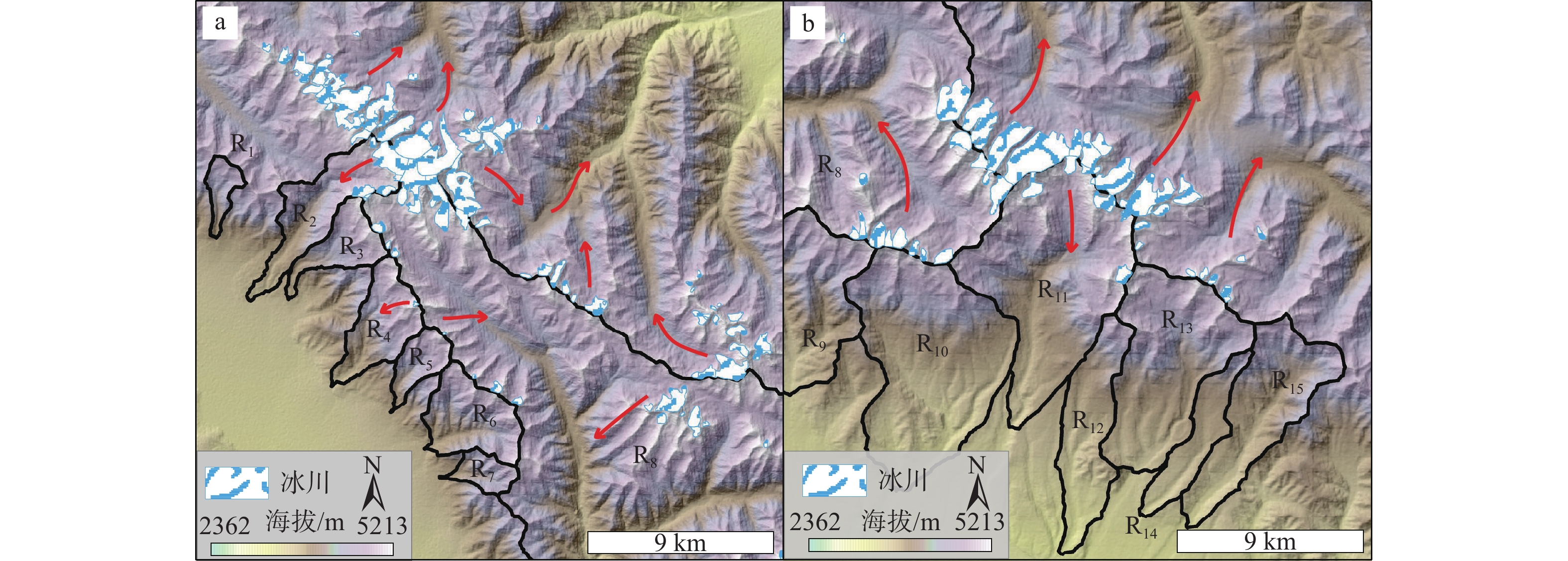
图 7 面积−高程积分空间分布特征
F1—冷龙岭断裂;F2—门源盆地北缘断裂;F3—门源盆地南缘断裂
Figure 7. Spatial distribution characteristics of area–elevation integral
F1–Lenglongling fault; F2–North margin fault of the Menyuan basin; F3–South margin fault of the Menyuan basin

图 8 河流纵剖面与河长坡降指数及盆地北缘断裂、河床地层岩性叠加图
黑色曲线为河流纵剖面;红色阶梯状曲线表示SL/K变化趋势;黑色虚线F2表示门源盆地北缘断裂主断裂位置
Figure 8. Overlay diagrams of river longitudinal profile and stream length–gradient index, north margin fault and riverbed lithology The black curve represents the longitudinal profile of the river, the red stepped curve indicates the trend of SL/K variations, and the black dashed line F3 denotes the main fault location of the north margin fault of the Menyuan basin.

图 10 研究区现代冰川分布特征(具体位置见图7;数据来自国家青藏高原科学数据中心
https://data.tpdc.ac.cn/home )红色箭头指示冰川融化后汇入方向a—河道R8西侧现代冰川覆盖情况;b—河道R8东侧现代冰川覆盖情况
Figure 10. Distribution characteristics of modern glacier cover in the study area (The position is shown in Figure 7; Data sources: national science data center of the qinghai-tibet plateau at
https://data.tpdc.ac.cn/home) )(a) Modern glacier cover on the west side of R8; Modern glacier cover on the east side of R8 The red arrows indicate the direction of glacier meltwater runoff.

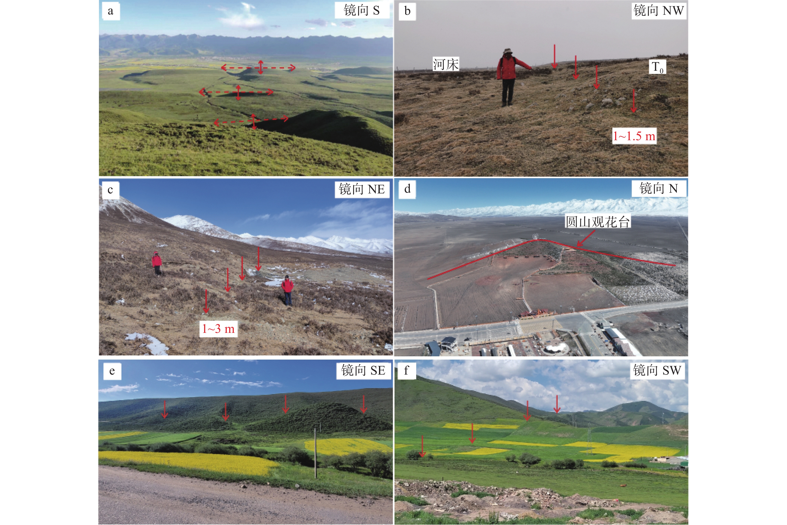
图 11 门源盆地中发育的断层及其变形表现(具体位置见图7)
a—门源盆地北缘断裂东段多排逆断层−褶皱带;b—门源盆地北缘断裂西段岗什卡滩高漫滩逆断层陡坎;c—门源盆地北缘断裂西段狼洞沟逆断层陡坎;d—门源盆地内部青石嘴镇处推测逆断层;e—铁迈附近断层槽谷及山脊位错;f—铁迈附近断层垭口及小的断层陡坎
Figure 11. The field photos of the Menyuan basin (The position is shown in Fig. 7)
(a) Multi-row reverse fault-fold belt in the east section of the north margin fault of the Menyuan basin; (b) Gangshikatan high overplain reverse fault in the west section of the north margin fault of the Menyuan basin; (c) Langdonggou reverse fault in the west section of the north margin fault of the Menyuan basin; (d) The reverse fault presumed in Qingshizui town, Menyuan basin; (e) Fault troughs and ridges dislocations near Tiemai; (f) Fault pass and small fault steepes near Tiemai

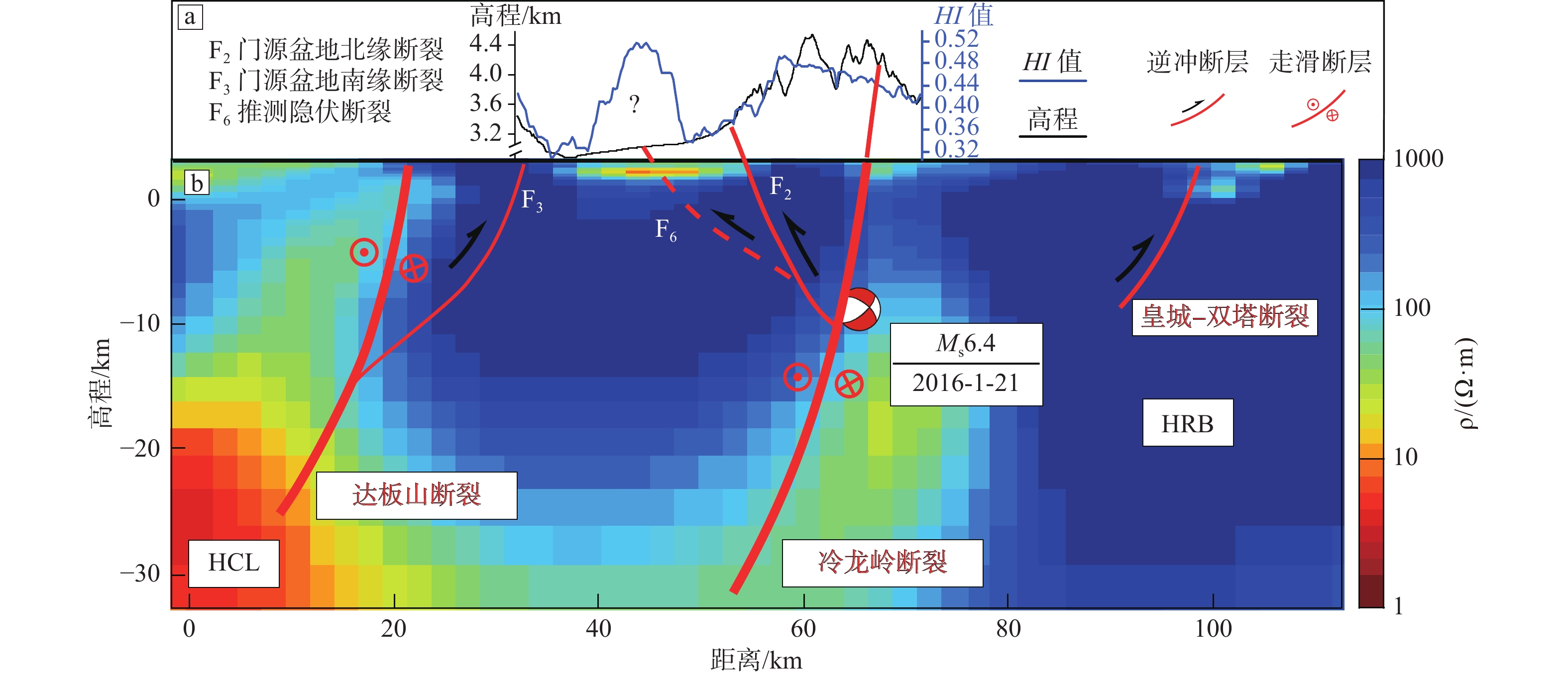
图 12 横穿研究区的地貌剖面和二维大地电磁结构模型(大地电磁剖面位置见图1a;据赵凌强等,2022修改)
HCL—地壳中的低阻结构;HRB—地壳中的高阻结构a—地貌剖面(具体位置见图7);b—大地电磁剖面
Figure 12. Geomorphic profile and two-dimensional magnetotelluric structural model obtained across the study area(The position of the geomorphic profile is shown in Fig. 7; The position of magnetotelluric profile is shown in Fig. 1a; Modified from Zhao et al., 2022) HCL–Low-resistivity structures in the crust; HRB–High-resistivity structures in the crust; a–Geomorphic profile; b–Magnetotelluric profile
表 1 面积阈值定义的次级集水流域属性
Table 1. Attributes of the sub-catchment basins defined by area threshold
面积阈值
/km2次集水盆地
个数平均面积/km2 平均高差
/m平均HI值 0.9 4818 1.327 375 0.4417 1.8 2333 2.724 474 0.4345 2.7 1640 3.861 530 0.4317 3.6 1187 5.310 574 0.4271 4.5 955 6.590 601 0.4240 5.4 796 7.887 630 0.4216  下载: 导出CSV
表 2 门源盆地北侧15条河道主要地貌参数
Table 2. Main geomorphic parameters of 15 river channels in the north side of the Menyuan basin
河道编号 河道名称 长度/km 面积/km2 最大高程/m 最小高程/m 坡度/(°) HI值 R1 无名沟1 2.25 4 3849 3541 7.87 0.54 R2 无名沟2 9.21 19 4341 3334 6.28 0.46 R3 黑沟 3.01 9 4062 3412 12.47 0.53 R4 岗龙沟 5.81 14 4072 3336 7.28 0.52 R5 外力沟 3.18 6 4000 3489 9.25 0.55 R6 无名沟3 3.94 15 3910 3456 6.62 0.49 R7 小萨拉沟 2.46 4 3826 3503 7.54 0.46 R8 老虎沟 26.79 250 4396 3200 2.56 0.47 R9 北沟 6.16 29 3820 3241 5.39 0.44 R10 歪里沟 9.71 38 3850 3035 4.81 0.36 R11 无名沟4 10.54 39 4234 3251 5.35 0.48 R12 三岔河 7.49 14 3561 2996 4.33 0.33 R13 无名沟5 7.96 27 4086 3260 5.96 0.46 R14 卡石头沟 5.32 8 3556 3173 4.13 0.31 R15 无名沟6 8.12 19 3722 3152 4.03 0.41 注:长度是基岩河道长度,面积表示基岩河道所对应的流域面积
下载: 导出CSV
-
[1] AN Z S, KUTZBACH J E, PRELL W L, et al. , 2001. Evolution of Asian monsoons and phased uplift of the Himalaya–Tibetan plateau since Late Miocene times[J]. Nature, 411(6833): 62-66. doi: 10.1038/35075035 [2] BURBANK P, 1999. Landscape evolution: the interactions of tectonics and surface processes[J]. Basin Research, 11(1): 1-6. doi: 10.1046/j.1365-2117.1999.00089.x [3] BURNETT A W, SCHUMM S A, 1983. Alluvial-river response to neotectonic deformation in Louisiana and Mississippi[J]. Science, 222(4619): 49-50. doi: 10.1126/science.222.4619.49 [4] CAO K, WANG G C, WANG A, 2007. The analysis of the tectonics and the behavior of the longitudinal section of Kunlun River in East Kunlun[J]. Earth Science—Journal of China University of Geosciences, 32(5): 713-721. (in Chinese with English abstract) [5] CAO P J, LIU X B, CHENG S Y, et al. , 2023. Geomorphic feature of the Zhuanglang River Basin in the eastern margin of Qilian Mountains and its tectonic implications[J]. Geographical Research, 42(1): 262-279. (in Chinese with English abstract) [6] CHAMPAGNAC J D, YUAN D Y, GE W P, et al. , 2010. Slip rate at the north-eastern front of the Qilian Shan, China[J]. Terra Nova, 22(3): 180-187. doi: 10.1111/j.1365-3121.2010.00932.x [7] CHANG Z Y, WANG J, BAI S B, et al. , 2015. Comparison of hypsometric integral methods[J]. Journal of Arid Land Resources and Environment, 29(3): 171-175. (in Chinese with English abstract) [8] CHEN Y C, SUNG Q, CHENG K Y, 2003. Along-strike variations of morphotectonic features in the western foothills of Taiwan: tectonic implications based on stream-gradient and hypsometric analysis[J]. Geomorphology, 56(1-2): 109-137. doi: 10.1016/S0169-555X(03)00059-X [9] CHEN Y J, 2008. Morphotectonic features of Taiwan mountain belt based on hypsometric integral, topographic fractals and SL index[D]. Tainan: National Cheng Kung University: 1-84. ( in Chinese with English abstract) [10] DAVIS W M, 1899. The geographical cycle[J]. The Geographical Journal, 14(5): 481-504. doi: 10.2307/1774538 [11] DONG J Y, LI C Y, ZHENG W J, et al. , 2021. Tectonic geomorphic features and geological significance of the Shidiquan anticline in the northern margin of the Qaidam basin[J]. Seismology and Geology, 43(3): 521-539. (in Chinese with English abstract) [12] GAI H L, LI Z M, YAO S H, et al. , 2022. Preliminary investigation and research on surface rupture characteristics of the 2022 Qinghai Menyuan MS6.9 earthquake[J]. Seismology and Geology, 44(1): 238-255. (in Chinese with English abstract) [13] GAO Z M, LIU X W, SHAO Y X, et al. , 2019. Geomorphological characteristics of Daqingshan drainage area in the northern margin of Hetao basin[J]. Seismology and Geology, 41(06): 1317-1332. (in Chinese with English abstract) [14] GUAN X, PANG L C, JIANG Y T, et al. , 2021. Spatial characteristics of quantitative geomorphic indices in the Taihang Mountains, north China: implications for tectonic geomorphology[J]. Journal of Geomechanics, 27(2): 280-293. (in Chinese with English abstract) [15] GUO H W, CHEN Y, LI J J, 1995. A preliminary study on the sequences of glaciers, loess records and terraces of the southern foothills of Lenlong Ling in Qilian Mountains[J]. Journal of Lanzhou University (Natural Sciences), 31(1): 102-110. (in Chinese with English abstract) [16] HACK J T, 1973. Stream-profile analysis and stream-gradient index[J]. Journal of Research of the U. S. Geological Survey, 1(4): 421-429. [17] HAN S, WU Z H, GAO Y, et al. , 2022. Surface rupture investigation of the 2022 Menyuan MS6.9 Earthquake, Qinghai, China: implications for the fault behavior of the Lenglongling fault and regional intense earthquake risk[J]. Journal of Geomechanics, 28(2): 155-168. (in Chinese with English abstract) [18] HARRISON T M, COPELAND P, KIDD W S F, et al. , 1992. Raising Tibet[J]. Science, 255(5052): 1663-1670. doi: 10.1126/science.255.5052.1663 [19] HETZEL R, TAO M X, STOKES S, et al. , 2004. Late Pleistocene/Holocene slip rate of the Zhangye thrust (Qilian Shan, China) and implications for the active growth of the northeastern Tibetan Plateau[J]. Tectonics, 23(6): TC6006. [20] HONG Y, ZHAO Y B, WANG Y S, et al. , 2019. Study on the geomorphic uplift characteristics of the Longmenshan fault zone using hypsometric integral method[J]. Science Technology and Engineering, 19(30): 43-51. (in Chinese with English abstract) [21] HU C Z, YANG P X, LI Z M, et al. , 2016. Seismogenic mechanism of the 21 January 2016 Menyuan, Qinghai MS6.4 earthquake[J]. Chinese Journal of Geophysics, 59(5): 1637-1646. (in Chinese with English abstract) [22] HU X F, 2010. The researches on temporal and spatial distributions of erosion rates and tectonic deformation in the Northern Oilian Shan[D]. Lanzhou: Lanzhou University: 1-143. (in Chinese with English abstract) [23] HU X F, PAN B T, KIRBY E, et al. , 2010. Spatial differences in rock uplift rates inferred from channel steepness indices along the northern flank of the Qilian Mountain, northeast Tibetan Plateau[J]. Chinese Science Bulletin, 55(27): 3205-3214. [24] JI Y P, GAO H S, PAN B T, et al. , 2011. Implication of active structure in the upper reaches of Weihe river basin from stream length-gradient index (SL index) and Hack profile[J]. Journal of Lanzhou University (Natural Sciences), 47(4): 1-6. (in Chinese with English abstract) [25] JOLIVET M, BRUNEL M, SEWARD D, et al. , 2001. Mesozoic and Cenozoic tectonics of the northern edge of the Tibetan Plateau: fission-track constraints[J]. Tectonophysics, 343(1-2): 111-134. doi: 10.1016/S0040-1951(01)00196-2 [26] KANG J C, ZHU J J, CHEN H K, 1992. Late quaternary glacial sequence on the south Slope of the Lenglongling, Qilian Mountains[J]. Journal of Glaciology and Geocryology, 14(4): 352-359. (in Chinese with English abstract) [27] LIANG M J, ZHOU R J, YAN L, et al. , 2014. The relationships between neotectonic activity of the middle segment of Dari fault and its geomorphological response, Qinghai Province, China[J]. Seismology and Geology, 36(1): 28-38. (in Chinese with English abstract) [28] LIFTON N A, CHASE C G, 1992. Tectonic, climatic and lithologic influences on landscape fractal dimension and hypsometry: implications for landscape evolution in the San Gabriel Mountains, California[J]. Geomorphology, 5(1-2): 77-114. doi: 10.1016/0169-555X(92)90059-W [29] LIU Q Y,MA Y,CHENG L.Geochemical Evaluation of Soil Quality in Menyuan County of Qinghai Province[J].Geology and Exploration, 2022,58(3):609-619. [30] MA B Q, LI D W, 2008. Stages of the neotectonic movement of the Menyuan basin in the middle segment of the Qilian mountains[J]. Journal of Geomechanics, 14(3): 201-211. (in Chinese with English abstract) [31] MA Z H, FENG Z T, PENG T J, et al. , 2020. Quaternary drainage evolution of the Datong River, Qilian Mountains, northeastern Tibetan Plateau, China[J]. Geomorphology, 353: 107021. doi: 10.1016/j.geomorph.2019.107021 [32] MASEK J G, ISACKS B L, GUBBELS T L, et al. , 1994. Erosion and tectonics at the margins of continental plateau[J]. Journal of Geophysical Research: Solid Earth, 99(B7): 13941-13956. doi: 10.1029/94JB00461 [33] MOLNAR P, TAPPONNIER P, 1975. Cenozoic tectonics of Asia: effects of a continental collision: features of recent continental tectonics in Asia can be interpreted as results of the India-Eurasia collision[J]. Science, 189(4201): 419-426. doi: 10.1126/science.189.4201.419 [34] MOLNAR P, ENGLAND P, 1990. Late Cenozoic uplift of mountain ranges and global climate change: chicken or eggs?[J]. Nature, 346(6279): 29-34. doi: 10.1038/346029a0 [35] MOLNAR P, ENGLAND P, MARTINOD J, 1993. Mantle dynamics, uplift of the Tibetan Plateau, and the Indian Monsoon[J]. Reviews of Geophysics, 31(4): 357-396. doi: 10.1029/93RG02030 [36] OUCHI S, 1985. Response of alluvial rivers to slow active tectonic movement[J]. GSA Bulletin, 96(4): 504-515. doi: 10.1130/0016-7606(1985)96<504:ROARTS>2.0.CO;2 [37] PALUMBO L, HETZEL R, TAO M X, et al. , 2009. Deciphering the rate of mountain growth during topographic presteady state: an example from the NE margin of the Tibetan Plateau[J]. Tectonics, 28(4): TC4017. [38] PANG J Z, YU J X, ZHENG D W, et al. , 2019. Neogene expansion of the Qilian Shan, North Tibet: implications for the dynamic evolution of the Tibetan Plateau[J]. Tectonics, 38(3): 1018-1032. doi: 10.1029/2018TC005258 [39] PIKE R J, WILSON S E, 1971. Elevation-relief ratio, hypsometric integral, and geomorphic area-altitude analysis[J]. GSA Bulletin, 82(4): 1079-1084. doi: 10.1130/0016-7606(1971)82[1079:ERHIAG]2.0.CO;2 [40] SEEBER L, GORNITZ V, 1983. River profiles along the Himalayan arc as indicators of active tectonics[J]. Tectonophysics, 92(4): 335-367. doi: 10.1016/0040-1951(83)90201-9 [41] SHAO C J, LI Y, ZHAO G H, et al. , 2015. Tectonic geomorphology analysis of piedmont rivers in the southern section of Longmenshan Based on hypsometric integral[J]. Geoscience, 29(4): 727-737. (in Chinese with English abstract) [42] SHI X M, DU Z C, 2006. Review and prospect of tectonic geomorphology in China[J]. Northwestern Seismological Journal, 28(3): 280-284. (in Chinese with English abstract) [43] SHI Y F, CUI J Z, SU Z, 2006. Glaciations and Environmental variations in China[M]. Hebei: Hebei Science and Technology Publishing House. [44] SHI Z T, ZHANG S Q, ZHOU S Z, et al. , 2000. Study of ESR dating of quaternary moraine, Qilian Mountains[J]. Journal of Glaciology and Geocryology, 2(4): 353-357. (in Chinese with English abstract) [45] SONG S G, NIU Y L, SU L, et al. , 2013. Tectonics of the North Qilian orogen, NW China[J]. Gondwana Research, 23(4): 1378-1401. doi: 10.1016/j.gr.2012.02.004 [46] STRAHLER A N, 1952. Dynamic basis of geomorphology[J]. GSA Bulletin, 63(9): 923-938. doi: 10.1130/0016-7606(1952)63[923:DBOG]2.0.CO;2 [47] SU Q, YUAN D Y, XIE H, et al. , 2016a. Geomorphic features of the Shule river drainage basin in Qilianshan and its insight into tectonic implications[J]. Seismology and Geology, 38(2): 240-258. (in Chinese with English abstract) [48] SU Q, YUAN D Y, XIE H, 2016b. Geomorphic features of the Heihe river drainage basin in western Qilian Shan-Hexi corridor and its tectonic implications[J]. Seismology and Geology, 38(3): 560-581. (in Chinese with English abstract) [49] SU Q, YUAN D Y, XIE H, 2017. Geomorphic features of the Shiyang River drainage basin and adjacent area in Eastern Qilian Mountains and its insight into tectonic implications[J]. Geological Review, 63(1): 7-20. (in Chinese with English abstract) [50] TAPPONNIER P, PELTZER G, LE DAIN A Y, 1982. Propagating extrusion tectonics in Asia: new insights from simple experiments with plasticine[J]. Geology, 10(12): 611-616. doi: 10.1130/0091-7613(1982)10<611:PETIAN>2.0.CO;2 [51] TAPPONNIER P, XU Z Q, ROGER F, et al. , 2001. Oblique stepwise rise and growth of the Tibet Plateau[J]. Science, 294(5547): 1671-1677. doi: 10.1126/science.105978 [52] WANG A, WANG G C, 2005. Review on morphotectonic and its analytical methods[J]. Geological Science and Technology Information, 24(4): 7-12, 20. (in Chinese with English abstract) [53] WANG Y Z, ZHANG H P, ZHENG D W, et al. , 2016. Stream-power incision model and its implications: discussion on the urgency of studying bedrock channel across the Tibetan Plateau[J]. Quaternary Sciences, 36(4): 884-897. (in Chinese with English abstract) [54] XU Y R, HE H L, DENG Q D, et al. , 2013. Quantitative river geomorphic parameters surrounding MTS. Huoshan, Shanxi province and their tectonic implications[J]. Quaternary Sciences, 33(4): 746-759. (in Chinese with English abstract) [55] YANG Z, 2014. The hydrological characteristics and rainfall landslides stability analysis of Menyuan basin, Qinghai Province[D]. Xi’an: Chang’an University: 1-81. (in Chinese with English abstract) [56] YAO S H, GAI H L, YIN X, et al. , 2020. Tectonic geomorphology and quaternary slip rate of the Xitieshan section of the Northern Margin Fault of Qaidam Basin[J]. Seismology and Geology, 42(6): 1385-1400. (in Chinese with English abstract) [57] YIN A, RUMELHART P E, BUTLER R, et al. , 2002. Tectonic history of the Altyn Tagh fault system in northern Tibet inferred from Cenozoic sedimentation[J]. Geological Society of America Bulletin, 114(10): 1257-1295. doi: 10.1130/0016-7606(2002)114<1257:THOTAT>2.0.CO;2 [58] YU H, BU F, HU D G, et al. , 2018. Ages and geological significance of the river terrace of Datong River in Qilian Mountains[J]. Geological Survey of China, 5(3): 43-48. (in Chinese with English abstract) [59] YUAN D Y, 2003. Tectonic deformation features and space-time evolution in Northeastern Margin of the Qinghai-Tibetan Plateau since the Late Cenozoic Time[D]. Beijing: Institute of Geology, China Earthquake Administrator: 1-173. (in Chinese with English abstract) [60] YUAN D Y, ZHANG P Z, LIU B C, et al. , 2004. Geometrical imagery and tectonic transformation of late quaternary active tectonics in Northeastern Margin of Qinghai-Xizang Plateau[J]. Acta Geologica Sinica, 78(2): 270-278. (in Chinese with English abstract) [61] YUAN D Y, GE W P, CHEN Z W, et al. , 2013. The growth of northeastern Tibet and its relevance to large-scale continental geodynamics: a review of recent studies[J]. Tectonics, 32(5): 1358-1370. doi: 10.1002/tect.20081 [62] YUAN D Y, XIE H, SU R H, et al. , 2023. Characteristics of co-seismic surface rupture zone of Menyuan MS6.9 earthquake in Qinghai Province on January 8, 2022 and seismogenic mechanism[J]. Chinese Journal of Geophysics, 66(1): 229-244. (in Chinese with English abstract) [63] ZHANG C, 2012. Geomorphic index analysis along the Yumu Shan and its implications for tectonic activities[D]. Lanzhou: Lanzhou University: 1-54. (in Chinese with English abstract) [64] ZHANG T Q, WANG Z, ZHANG X M, et al. , 2015. Hypsometric integral analysis of the Ürümqi river drainage basin and its implications for topographic evolution[J]. Quaternary Sciences, 35(1): 60-70. (in Chinese with English abstract) [65] ZHANG Y N, HU X F, PAN Y F, 2022. Comparison of geomorphic characteristics between the northern Qilian Shan and eastern Kunlun shan and its indications for tectonic uplift[J]. Quaternary Sciences, 42(3): 809-822. (in Chinese with English abstract) [66] ZHAO G H, LI Y, YAN Z K, et al. , 2014. Tectonic geomorphology analysis of piedmont rivers of the middle MT. Longmenshan based on Hack profile and hypsometric integral[J]. Quaternary Sciences, 34(2): 302-311. (in Chinese with English abstract) [67] ZHAO H Z, LI Y L, YANG J C, et al. , 2010a. Influence of area and space dependence for hypsometric integral and its geological implications[J]. Geographical Research, 29(2): 271-282. (in Chinese with English abstract) [68] ZHAO H Z, LI Y L, YANG J C, 2010b. Implication of active structure along the Northern Tianshan by stream length-gradient index and hack profile[J]. Acta Scientiarum Naturalium Universitatis Pekinensis, 46(2): 237-244. (in Chinese with English abstract) [69] ZHAO J D, ZHOU S Z, SHI Z T, et al. , 2001. ESR dating of glacial tills of Baishuihe River on the southern slope of Lenglongling in the Eastern Part of Qilian Mountains[J]. Journal of Lanzhou University (Natural Sciences), 37(4): 110-116. (in Chinese with English abstract) [70] ZHAO L Q, SUN X Y, ZHAN Y, et al. , 2022. The seismogenic model of the Menyuan MS6.9 earthquake on January 8, 2022, Qinghai Province and segmented extensional characteristics of the Lenglongling fault[J]. Chinese Journal of Geophysics, 65(4): 1536-1546. (in Chinese with English abstract) [71] ZHENG D W, WANG W T, WAN J L, et al. , 2017. Progressive northward growth of the northern Qilian Shan–Hexi Corridor (northeastern Tibet) during the Cenozoic[J]. Lithosphere, 9(3): 408-416. doi: 10.1130/L587.1 [72] ZHENG G Y, 2022. The implications of hypsometric integral for river basins in the mountain front of western Taiwan[D]. Gaoxiong, China: National Kaohsiung Normal University: 33-37. (in Chinese with English abstract) [73] ZHENG W J, 2009. Geometric pattern and active tectonics of the Hexi Corridor and its adjacent regions[D]. Beijing: Institute of Geology, China Earthquake Administrator: 1-220. (in Chinese with English abstract) [74] ZHENG W J, ZHANG P Z, GE W P, et al. , 2013. Late Quaternary slip rate of the South Heli Shan Fault (northern Hexi Corridor, NW China) and its implications for northeastward growth of the Tibetan Plateau[J]. Tectonics, 32(2): 271-293. doi: 10.1002/tect.20022 [75] ZHENG W J, ZHANG B X, YUAN D Y, et al. , 2021. Tectonic activity in the Southern Alashan block and the latest boundary of outward expansion on the northeastern Tibetan Plateau, China[J]. Journal of Earth Sciences and Environment, 43(2): 224-236. (in Chinese with English abstract) [76] ZHOU S Z, LI J J, 2003. New dating results of quaternary glaciations in China[J]. Journal of Glaciology and Geocryology, 25(6): 660-666. (in Chinese with English abstract) [77] ZHANG Y X, 2003. The hypsometric analysis of Taiwan and its tectonic implication[D]. National Kaohsiung Normal University, Kaohsiung: 1—110. ( in Chinese with English abstract) [78] ZUO Q CH, YE T ZH, FENG Y F et al. , 2018. Spatial database of 1∶ 250, 000 construction and structure maps of China[J]. Geology in China, 45(S1): 1-26. [79] 曹凯, 王国灿, 王岸, 2007. 东昆仑山昆仑河纵剖面形貌分析及构造涵义[J]. 地球科学-中国地质大学学报, 32(5): 713-721. [80] 曹鹏举, 刘晓波, 程三友, 等, 2023. 祁连山东段庄浪河流域地貌特征及其构造指示意义[J]. 地理研究, 42(1): 262-279. doi: 10.11821/dlyj020220345 [81] 常直杨, 王建, 白世彪, 等, 2015. 面积高程积分值计算方法的比较[J]. 干旱区资源与环境, 29(3): 171-175. doi: 10.13448/j.cnki.jalre.2015.100 [82] 陈彦杰, 2004. 台湾山脉的构造地形指标特性: 以面积高度积分、地形碎形参数与河流坡降指标为依据[D]. 台南: 国立成功大学: 1-84. [83] 董金元, 李传友, 郑文俊, 等, 2021. 柴达木盆地北缘石底泉背斜构造地貌特征及地质意义[J]. 地震地质, 43(3): 521-539. doi: 10.3969/j.issn.0253-4967.2021.03.004 [84] 盖海龙, 李智敏, 姚生海, 等, 2022. 2022年青海门源MS6.9地震地表破裂特征的初步调查研究[J]. 地震地质, 44(1): 238-255. doi: 10.3969/j.issn.0253-4967.2022.01.015 [85] 高泽民, 刘兴旺, 邵延秀, 等, 2019. 河套盆地北缘大青山地区构造地貌特征[J]. 地震地质, 41(6): 1317-1332. doi: 10.3969/j.issn.0253-4967.2019.06.001 [86] 关雪, 逄立臣, 姜雨彤, 等, 2021. 太行山地貌计量指标空间特征及其构造地貌意义[J]. 地质力学学报, 27(2): 280-293. doi: 10.12090/j.issn.1006-6616.2021.27.02.026 [87] 郭红伟, 陈晔, 李吉均, 1995. 祁连山冷龙岭南麓的冰川序列、黄土记录和阶地系列的初步研究[J]. 兰州大学学报(自然科学版), 31(1): 102-110. doi: 10.13885/j.issn.0455-2059.1995.01.019 [88] 韩帅, 吴中海, 高扬, 等, 2022. 2022年1月8日青海门源MS6.9地震地表破裂考察的初步结果及对冷龙岭断裂活动行为和区域强震危险性的启示[J]. 地质力学学报, 28(2): 155-168. [89] 洪艳, 赵银兵, 王运生, 等, 2019. 利用面积高程积分方法研究龙门山断裂带地貌隆升特征[J]. 科学技术与工程, 19(30): 43-51. doi: 10.3969/j.issn.1671-1815.2019.30.007 [90] 胡朝忠, 杨攀新, 李智敏, 等, 2016. 2016年1月21日青海门源6.4级地震的发震机制探讨[J]. 地球物理学报, 59(5): 1637-1646. doi: 10.6038/cjg20160509 [91] 胡小飞, 2010. 祁连山北部侵蚀速率的时空分布与构造抬升变形研究[D]. 兰州: 兰州大学: 1-143. [92] 胡小飞, 潘保田, KIRBY E, 等, 2010. 河道陡峭指数所反映的祁连山北翼抬升速率的东西差异[J]. 科学通报, 55(23): 2329-2338. [93] 吉亚鹏, 高红山, 潘保田, 等, 2011. 渭河上游流域河长坡降指标SL参数与Hack剖面的新构造意义[J]. 兰州大学学报(自然科学版), 47(4): 1-6. doi: 10.13885/j.issn.0455-2059.2011.04.018 [94] 康建成, 朱俊杰, 陈宏凯, 1992. 祁连山冷龙岭南坡晚第四纪冰川演化序列[J]. 冰川冻土, 14(4): 352-359. [95] 梁明剑, 周荣军, 闫亮, 等, 2014. 青海达日断裂中段构造活动与地貌发育的响应关系探讨[J]. 地震地质, 36(1): 28-38. doi: 10.3969/j.issn.0253-4967.2014.01.003 [96] 刘庆宇, 马瑛, 程莉. 2022.青海门源县土壤质量地球化学评价[J].地质与勘探, 58(3):609-619. [97] 马保起, 李德文, 2008. 祁连山中段门源盆地新构造运动的阶段划分[J]. 地质力学学报, 14(3): 201-211. doi: 10.3969/j.issn.1006-6616.2008.03.002 [98] 邵崇建, 李勇, 赵国华, 等, 2015. 基于面积-高程积分对龙门山南段山前河流的构造地貌研究[J]. 现代地质, 29(4): 727-737. doi: 10.3969/j.issn.1000-8527.2015.04.002 [99] 史兴民, 杜忠潮, 2006. 中国构造地貌学的回顾与展望[J]. 西北地震学报, 28(3): 280-284. [100] 施雅风, 崔之久, 苏珍, 2006. 中国第四纪冰川与环境变化[M]. 河北: 河北科学技术出版社. [101] 史正涛, 张世强, 周尚哲, 等, 2000. 祁连山第四纪冰碛物的ESR测年研究[J]. 冰川冻土, 22(4): 353-357. [102] 苏琦, 袁道阳, 谢虹, 等, 2016a. 祁连山西段疏勒河流域地貌特征及其构造意义[J]. 地震地质, 38(2): 240-258. [103] 苏琦, 袁道阳, 谢虹, 2016b. 祁连山—河西走廊黑河流域地貌特征及其构造意义[J]. 地震地质, 38(3): 560-581. [104] 苏琦, 袁道阳, 谢虹, 2017. 祁连山东段石羊河流域及邻区地貌特征及其构造意义[J]. 地质论评, 63(1): 7-20. [105] 王岸, 王国灿, 2005. 构造地貌及其分析方法述评[J]. 地质科技情报, 24(4): 7-12, 20. [106] 王一舟, 张会平, 郑德文, 等, 2016. 基岩河道河流水力侵蚀模型及其应用: 兼论青藏高原基岩河道研究的迫切性[J]. 第四纪研究, 36(4): 884-897. doi: 10.11928/j.issn.1001-7410.2016.04.09 [107] 徐岳仁, 何宏林, 邓起东, 等, 2013. 山西霍山山脉河流地貌定量参数及其构造意义[J]. 第四纪研究, 33(4): 746-759. doi: 10.3969/j.issn.1001-7410.2013.04.12 [108] 杨珍, 2014. 青海省门源盆地水文特征与降雨型滑坡稳定性分析[D]. 西安: 长安大学: 1-81. [109] 姚生海, 盖海龙, 殷翔, 等, 2020. 柴达木盆地北缘断裂(锡铁山段)的构造地貌特征与晚第四纪活动速率[J]. 地震地质, 42(6): 1385-1400. doi: 10.3969/j.issn.0253-4967.2020.06.008 [110] 于航, 步凡, 胡道功, 等, 2018. 祁连山大通河河流阶地形成时代及地质意义[J]. 中国地质调查, 5(3): 43-48. [111] 袁道阳, 2003. 青藏高原东北缘晚新生代以来的构造变形特征与时空演化[D]. 北京: 中国地震局地质研究所: 1-173. [112] 袁道阳, 张培震, 刘百篪, 等, 2004. 青藏高原东北缘晚第四纪活动构造的几何图像与构造转换[J]. 地质学报, 78(2): 270-278. doi: 10.3321/j.issn:0001-5717.2004.02.017 [113] 袁道阳, 谢虹, 苏瑞欢, 等, 2023. 2022年1月8日青海门源MS6.9地震地表破裂带特征与发震机制[J]. 地球物理学报, 66(1): 229-244. doi: 10.6038/cjg2022Q0093 [114] 张忱, 2012. 祁连山中段榆木山地区地貌指数分析及其活动构造意义[D]. 兰州: 兰州大学: 1-54. [115] 张天琪, 王振, 张晓明, 等, 2015. 北天山乌鲁木齐河流域面积-高程积分及其地貌意义[J]. 第四纪研究, 35(1): 60-70. [116] 张亚男, 胡小飞, 潘彦菲, 2022. 北祁连山和东昆仑山的地貌特征对比及其对构造抬升的指示意义[J]. 第四纪研究, 42(3): 809-822. doi: 10.11928/j.issn.1001-7410.2022.03.15 [117] 张韵娴, 2003. 台湾地区流域面积高程积分值之研究[D]. 高雄: 国立高雄师范大学: 1-110. [118] 赵国华, 李勇, 颜照坤, 等, 2014. 龙门山中段山前河流Hack剖面和面积-高程积分的构造地貌研究[J]. 第四纪研究, 34(2): 302-311. doi: 10.3969/j.issn.1001-7410.2014.02.04 [119] 赵洪壮, 李有利, 杨景春, 等, 2010a. 面积高度积分的面积依赖与空间分布特征[J]. 地理研究, 29(2): 271-282. [120] 赵洪壮, 李有利, 杨景春, 2010b. 北天山流域河长坡降指标与Hack剖面的新构造意义[J]. 北京大学学报(自然科学版), 46(2): 237-244. doi: 10.13209/j.0479-8023.2010.034 [121] 赵井东, 周尚哲, 史正涛, 等, 2001. 祁连山东段冷龙岭南麓白水河冰碛物ESR测年研究[J]. 兰州大学学报, 37(4): 110-116. [122] 赵凌强, 孙翔宇, 詹艳, 等, 2022. 2022年1月8日青海门源MS6.9地震孕震环境和冷龙岭断裂分段延展特征[J]. 地球物理学报, 65(4): 1536-1546. doi: 10.6038/cjg2022Q0051 [123] 郑光佑, 2002. 台湾西部麓山带前缘流域面积高度积分之构造意义研究[D]. 高雄: 国立高雄师范大学: 33-37. [124] 郑文俊, 2009. 河西走廊及其邻区活动构造图像及构造变形模式[D]. 北京: 中国地震局地质研究所: 1-220. [125] 郑文俊, 张博譞, 袁道阳, 等, 2021. 阿拉善地块南缘构造活动特征与青藏高原东北缘向外扩展的最新边界[J]. 地球科学与环境学报, 43(2): 224-236. [126] 周尚哲, 李吉均, 2003. 第四纪冰川测年研究新进展[J]. 冰川冻土, 25(6): 660-666. [127] 左群超, 叶天竺, 冯艳芳, 等, 2018. 中国陆域 1∶25 万分幅建造构造图空间数据库[J]. 中国地质, 45(S1): 1-26. doi: 10.12029/gc2018Z101 -

 下载:
下载:


计量
- 文章访问数: 1714
- HTML全文浏览量: 694
- PDF下载量: 101
- 被引次数: 0
