

Analysis of the development characteristics of co-seismic geological hazards and their controlling factors in the Maerkang MS 6.0 earthquake swarm, Sichuan, on June 10, 2022
-
摘要: 为了揭示震群型同震地质灾害的分布规律和特征,理清不同类型地震诱发地质灾害的差异性,进一步认识巴颜喀拉地块周边和内部的地震风险,从而高效指导地震诱发次生地质灾害预测与防治工作,文章以2022年马尔康MS6.0震群同震地质灾害为研究对象,通过对震群序列数据、区域构造环境研究成果、区域地壳形变研究数据、震后短期内的地质灾害数据等进行系统分析研究,揭示马尔康MS6.0震群的区域和深部构造环境、同震地质灾害的主控因素。结果表明:马尔康MS6.0震群是发生在周缘边界活动性极强的巴颜喀拉地块内部次级断裂上强震空区内的深部粘滑型地震,多次震级相近的地震可能是由于松岗断裂的次级断裂破裂和之间的隔堤相继破裂的结果;地震新增地质灾害隐患83处,导致地质灾害隐患点变形加剧106处,并诱发了多处高位滑坡和系列震裂山体,震后震中草登乡地质灾害极高、高、中风险区面积分别占比1.62%、4.80%和12.37%;地震诱发同震地质灾害的控制因素由主到次为发震断裂及其关联断裂、地震震级及能量衰减、地形坡度及高差、岩体结构及结构面密度。此次发震的松岗断裂与龙日坝活动断裂交切区未来强震风险高,发震断裂及与其有联动效应的断裂周边在地震时发生地质灾害风险高。Abstract:
Objective This study aims to reveal the distribution patterns and characteristics of co-seismic geological hazards in earthquake swarms, clarify the differences in induced geological hazards by different types of earthquakes, further understand the seismic risks around and within the Bayan Har Block, and provide efficient guidance for the prediction and prevention of secondary geological hazards induced by earthquakes. Methods We take the co-seismic geological hazards of the Maerkang MS 6.0 earthquake swarm in 2022 as the research focus. Through systematic data and results analysis on earthquake swarm sequence, regional tectonic environment, regional crustal deformation, and post-earthquake short-term geological hazard, the regional and deep structural environment of the Maerkang MS 6.0 earthquake swarm and the main controlling factors of co-seismic geological hazards are revealed. Results The results show that the Maerkang MS 6.0 earthquake swarm is a deep-seated sticky-slip earthquake that occurred on a secondary fault in the active strong earthquake zone within the Bayan Har block, a region with extremely strong peripheral boundary activity. The earthquakes with similar magnitudes may be the result of ruptures of secondary faults of the Songgang fault and the successive ruptures of the barriers between them. The earthquake has resulted in 83 newly discovered geological hazard risks, exacerbating deformation in 106 existing hazard spots and triggering multiple high-altitude landslides and a series of fractured mountain slopes. The areas of extreme, high, and medium geological hazard risk in Caodeng Town, the epicenter area after the earthquake, account for 1.62%, 4.80%, and 12.37%, respectively. The occurrence of secondary geological hazards following earthquakes exhibits a positive correlation with the earthquake magnitude, with the number increasing linearly as the magnitude rises. Conclusion The significant differences in the GPS horizontal velocity field and vertical velocity field on both sides of the Darlag–Songgang–Fubianhe fault zone are key factors contributing to the activity of this fault and triggering the recent earthquake.The main controlling factors of co-seismic geological hazards induced by earthquakes are, from primary to secondary, the ruptured fault and its associated faults, seismic magnitude and energy attenuation, terrain slope and altitude difference, and rock mass structure and density of structural surfaces. Significance This study predicts a high risk of future strong earthquakes in the intersection area of the Songgang fault, which triggered this earthquake, and the Longriba active fault. The surrounding area of the seismogenic fault and its associated faults are at a high risk of geological hazards during earthquakes. The findings provides a reference for predicting and controlling the risk of co-seismic geological hazards in this area. -

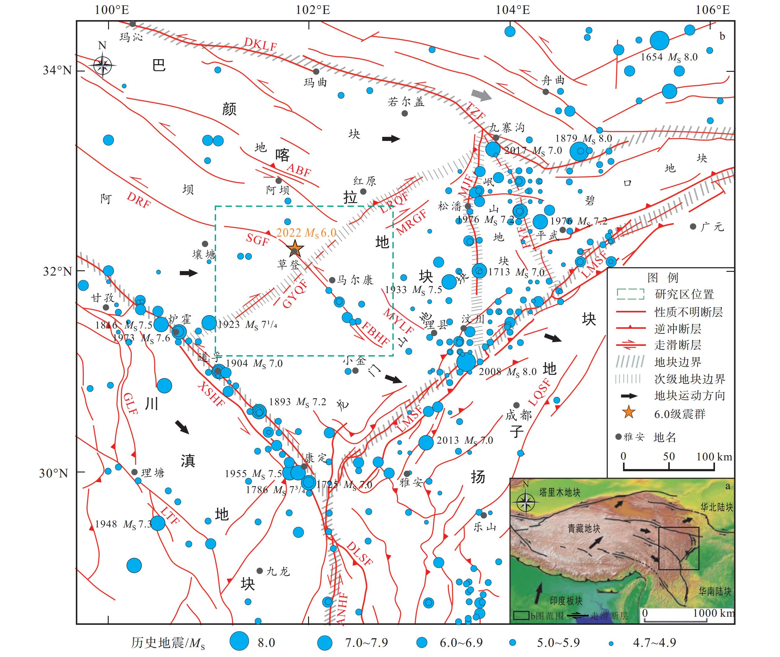
图 1 研究区区域构造纲要图
DKLF—东昆仑断裂;TZF—塔藏断裂;ABF—阿坝断裂;LRQF—龙日曲断裂;MRGF—毛尔盖断裂;GYQF—观音桥断裂;DRF—达日断裂;SGF—松岗断裂;FBHF—抚边河断裂;MYLF—米亚罗断裂;MJF—岷江断裂;HYF—虎牙断裂;XSHF—鲜水河断裂带;LMSF—龙门山断裂带;GLF—甘孜−理塘断裂;LTF—理塘断裂;DLSF—大凉山断裂;ANHF—安宁河断裂a—研究区构造区位图 ; b—研究区区域构造图
Figure 1. Outline Map of Regional Structure in the Study Area
(a) Location map of the study area; (b) Regional structural map of the study areaDKLF–East Kunlun Fault; TZF–Tazang Fault, ABF–Aba Fault; LRQF–Longriqu Fault; MRGF–Maoergai Fault; GYQF–Guanyinqiao Fault; DRF–Dari Fault; SGF–Songgang Fault; FBHF–Fubianhe Fault; MYLF–Miyaluo Fault; MJF–Minjiang Fault; HYF–Huya Fault; XSHF–Xianshuihe Fault Zone; LMSF–Longmenshan Fault Zone; GLF–Ganzi–Litang Fault; LTF–Litang Fault; DLSF–Daliangshan Fault; ANHF–Anninghe Fault
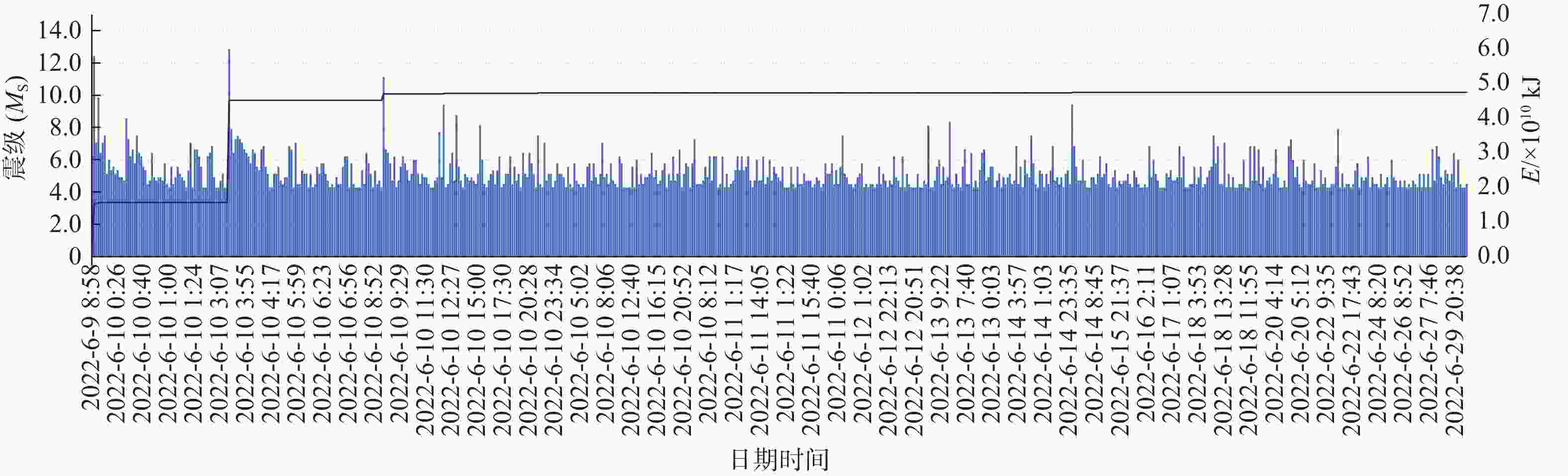
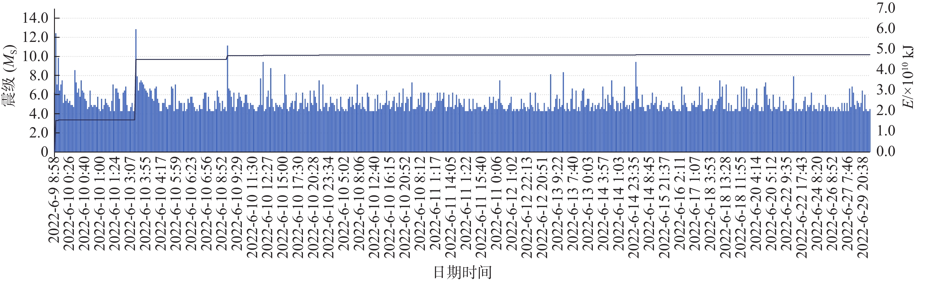
图 2 马尔康MS6.0震群地震序列和能量释放图
Figure 2. Plot showing the earthquake sequence and energy release of the Maerkang MS 6.0 earthquake swarm
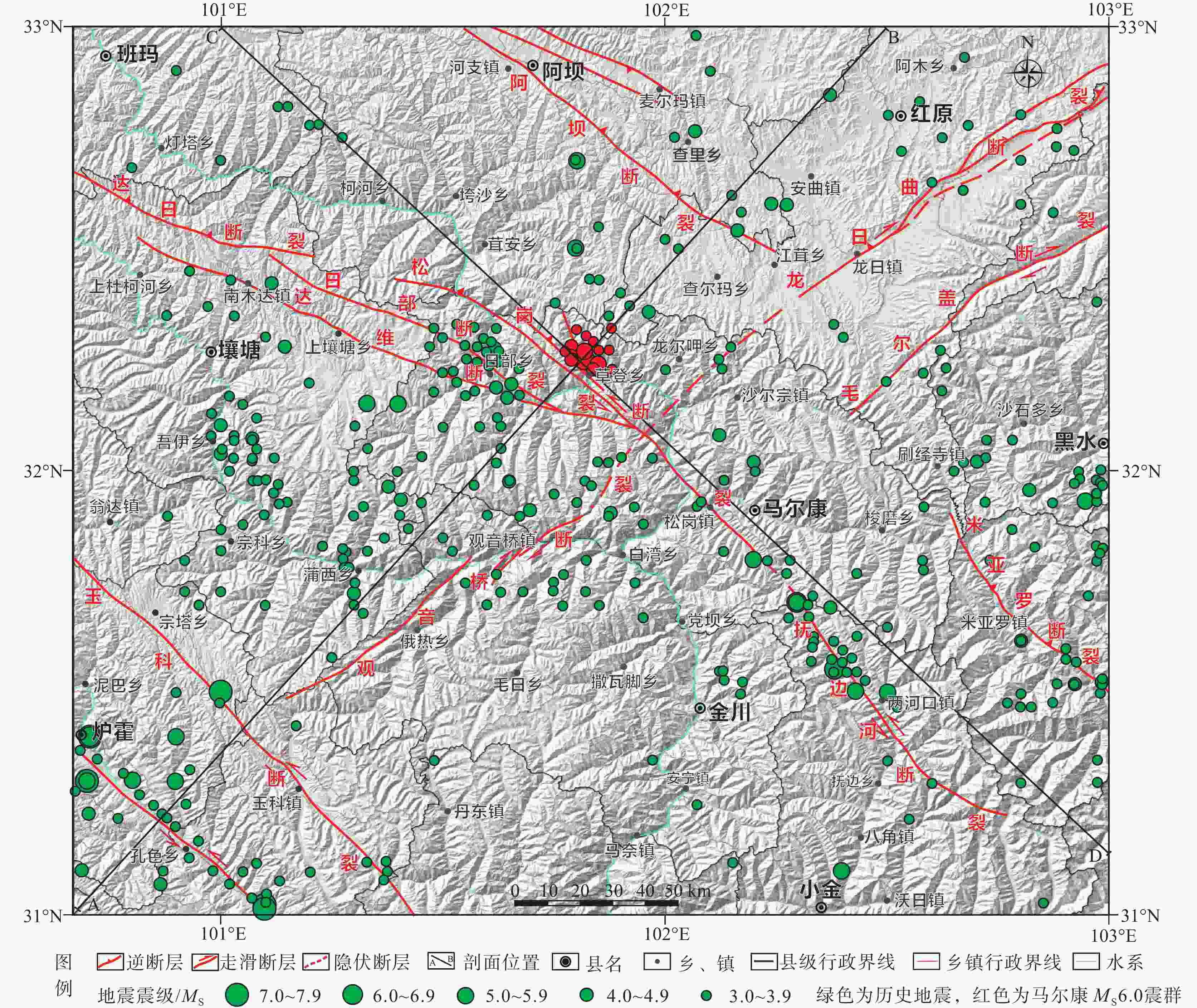
图 3 马尔康MS 6.0震群地震地质略图(数据来源:中国地震局官网
http://www.cea.gov.cn )Figure 3. Seismic geological sketch of the Maerkang MS 6.0 earthquake swarm(data source: China Earthquake Administration Official Website http://www.cea.gov.cn)
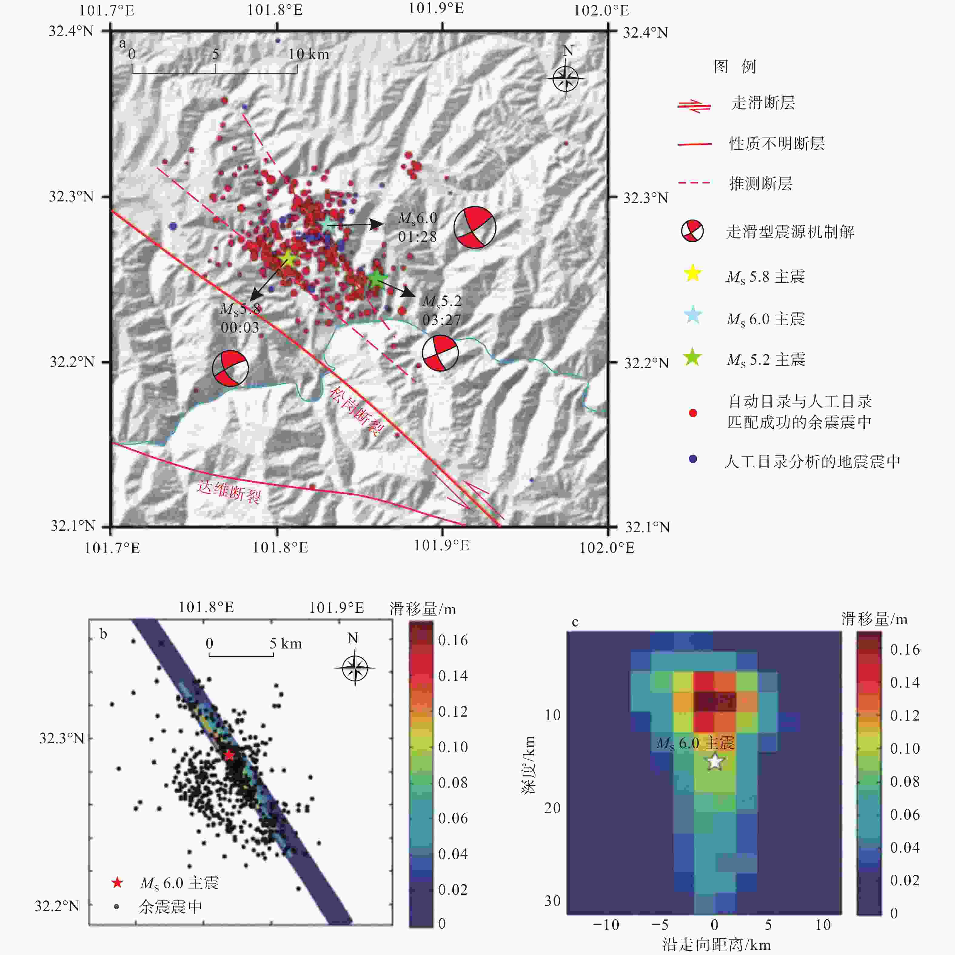
图 4 马尔康MS6.0震群地震震源区破裂过程图
a—地震震中(引自颜利君等(2022)、张建勇等(2022),有修改;地震统计时间为 2022 年 6 月 10 日 0 —12 时);b—马尔康MS 6.0震群地震断层滑移分布投影;c—马尔康MS 6.0震群地震断层面滑动分布(引自张建勇等(2022),地震统计时间为 2022 年 6 月 10 日 0 —7 时)
Figure 4. Diagrams showing the rupture process in the source area of the Markang MS 6.0 earthquake swarm
(a)Earthquake epicenter; (b)Projection of fault slip distribution of the MS 6.0 Maerkang earthquake; (c)Surface slip distribution of the faults in the MS 6.0 Maerkang earthquake Note: Fig 4a was modified from Yan et al., 2022, Zhang et al., 2022; Earthquake statistics were taken from June 10, 2022, 0:00~12:00. Fig. 4b and 4c were adapted from Zhang et al., 2022; Earthquake statistics were taken from June 10, 2022, 0:00~7:00.
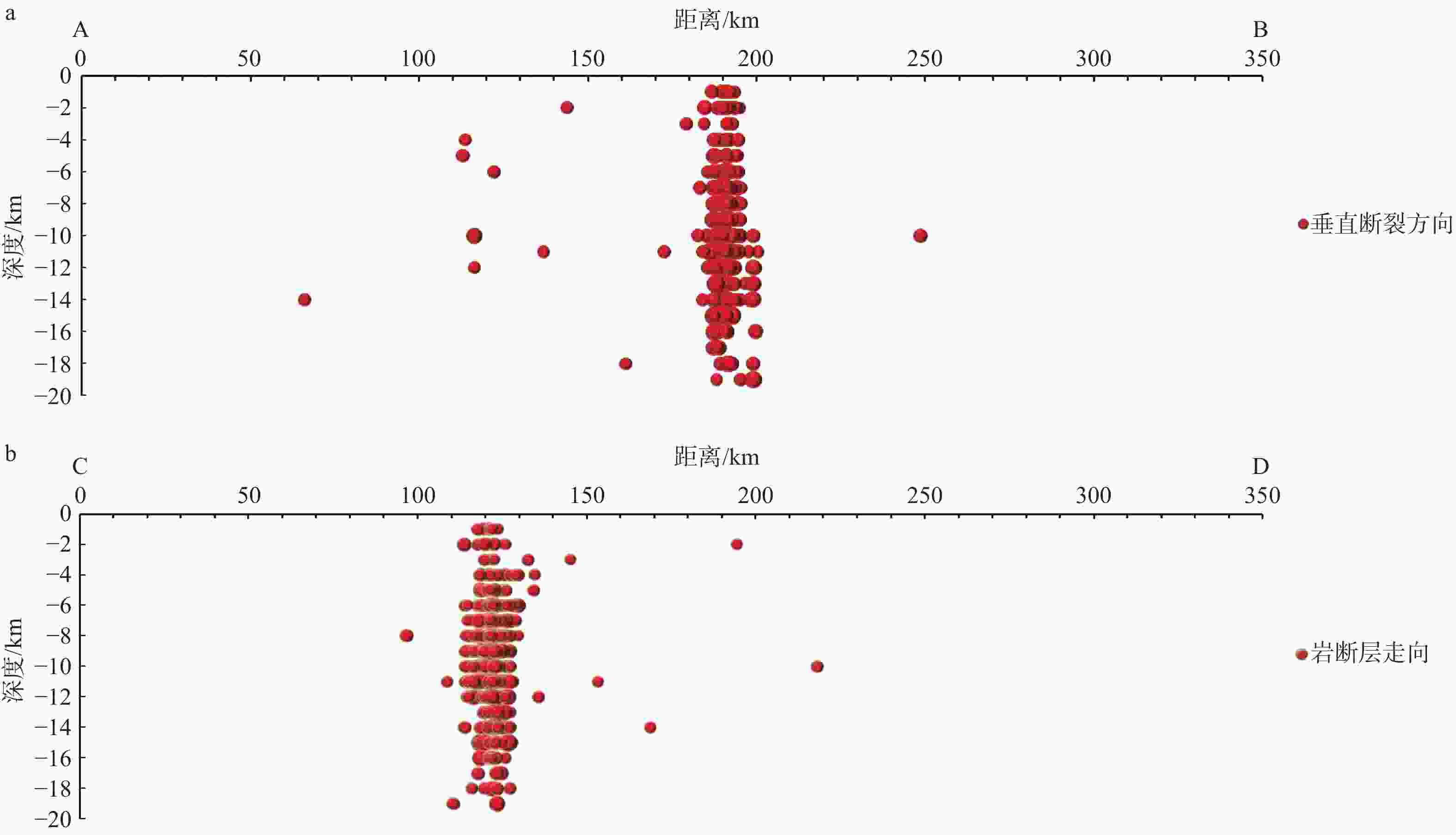
图 5 马尔康MS6.0震群震中分布图(剖面位置见图3,统计时间截止2022年6月30日)
a—垂直断层方向(剖面AB);b—沿断层方向(剖面CD)
Figure 5. Distribution map of the epicenters of the Maerkang MS 6.0 earthquake swarm (The cross-sectional position is shown in Fig. 3)
(a)Vertical fault direction (Profile AB);(b)Along the fault direction (Profile CD), with statistics up to June 30th,2022
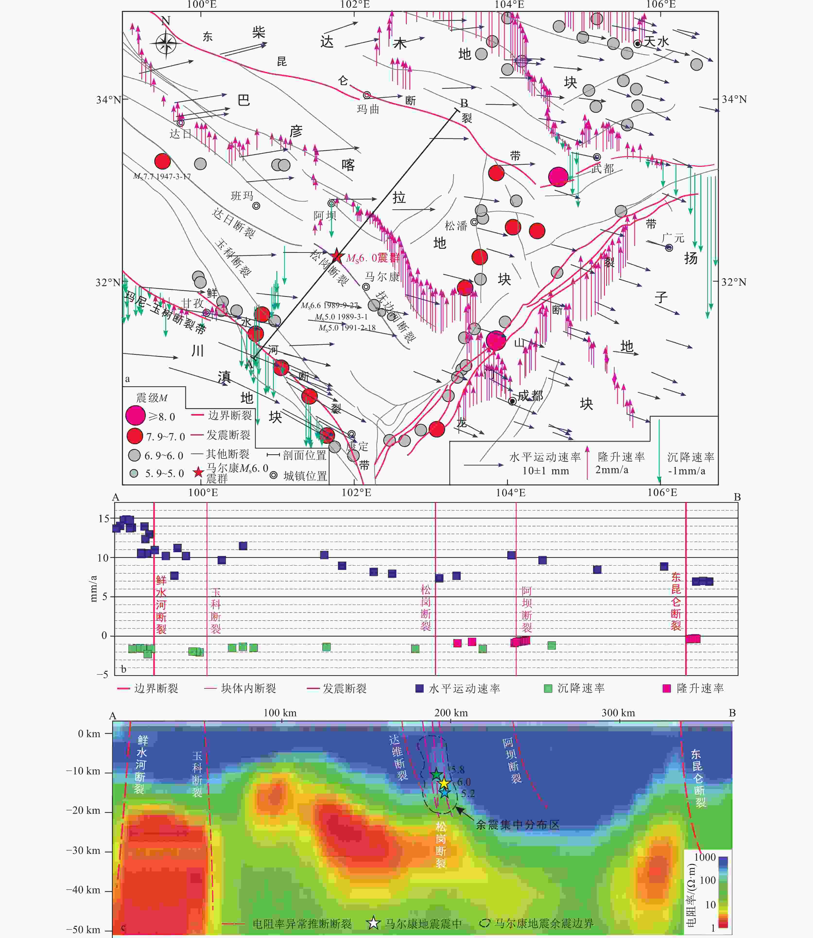
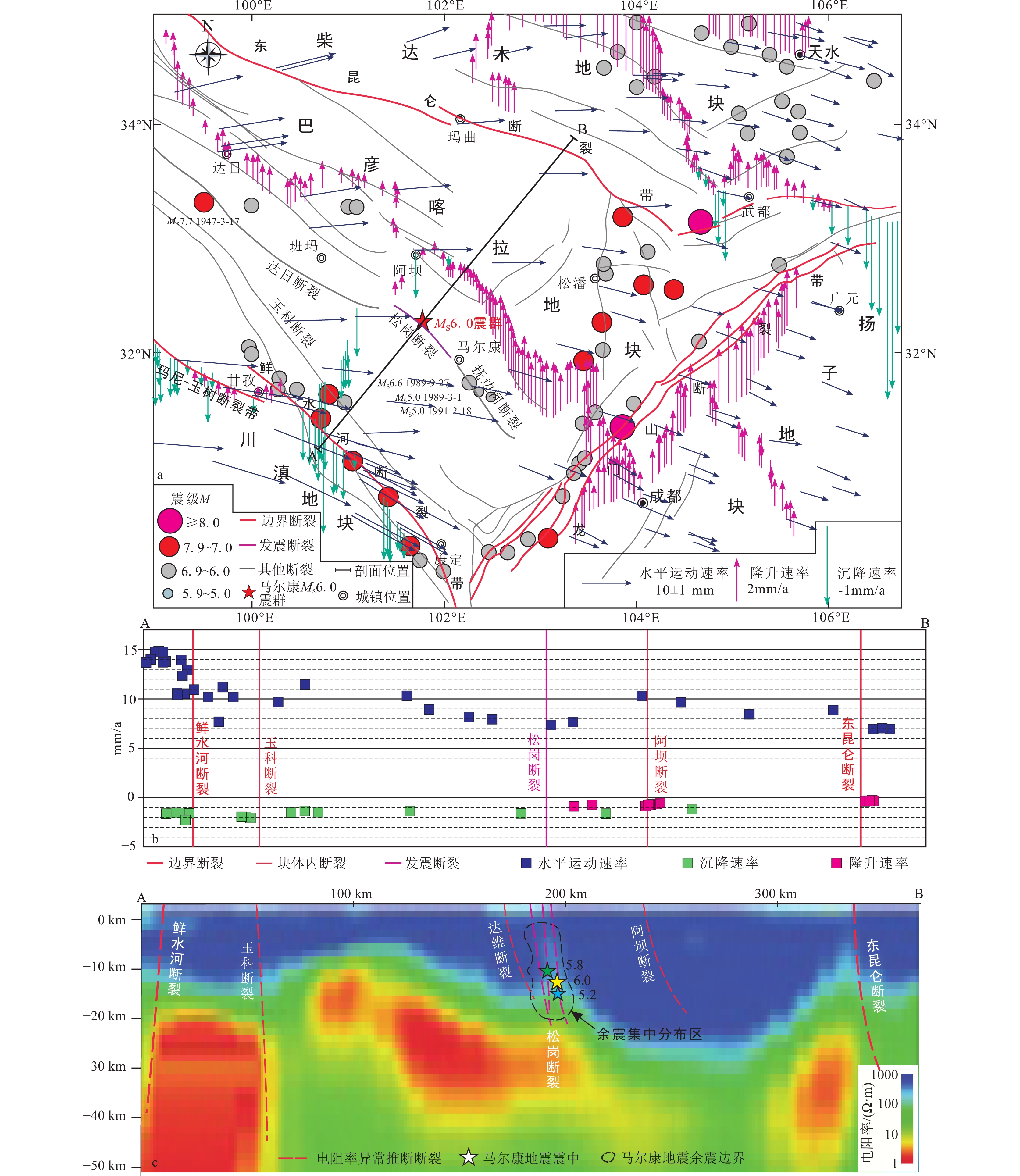
图 6 马尔康MS6.0震群构造环境剖面图(GPS水平速度场数据来源:Wang and Shen,2020;陈长云等,2022;地球物理数据来源:Bai et al.,2010)
a—区域地震构造环境;b—AB剖面各构造单元地壳运动特征及水准垂直速度(1980—2010年):c—深部构造剖面;
Figure 6. Structural environment profile of the Maerkang MS 6.0 earthquake swarm ( GPS horizontal velocity field data source in Fig 6a and 6b is from Wang and Shen, 2020, Chen et al., 2022; Geophysical data in Fig.6c is from Bai et al., 2010.)
(a) Regional seismic tectonic environment; (b) Crustal movement characteristics and vertical velocity of each tectonic unit along profile AB (1980–2010); (c) Deep structural profile
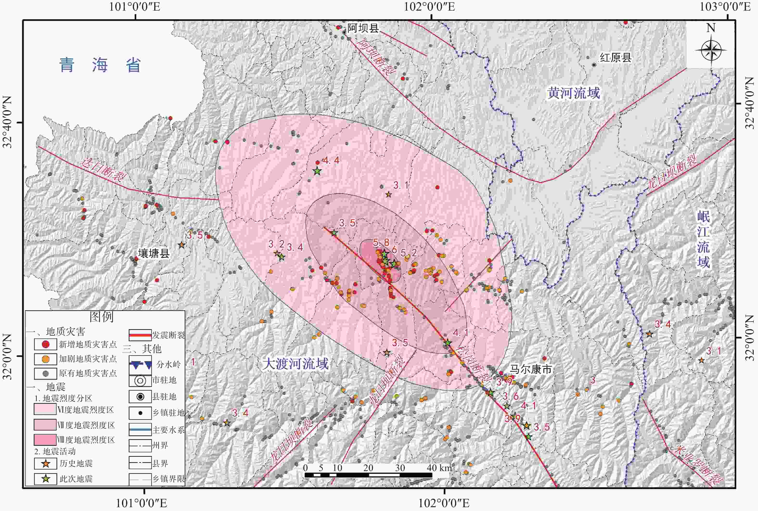
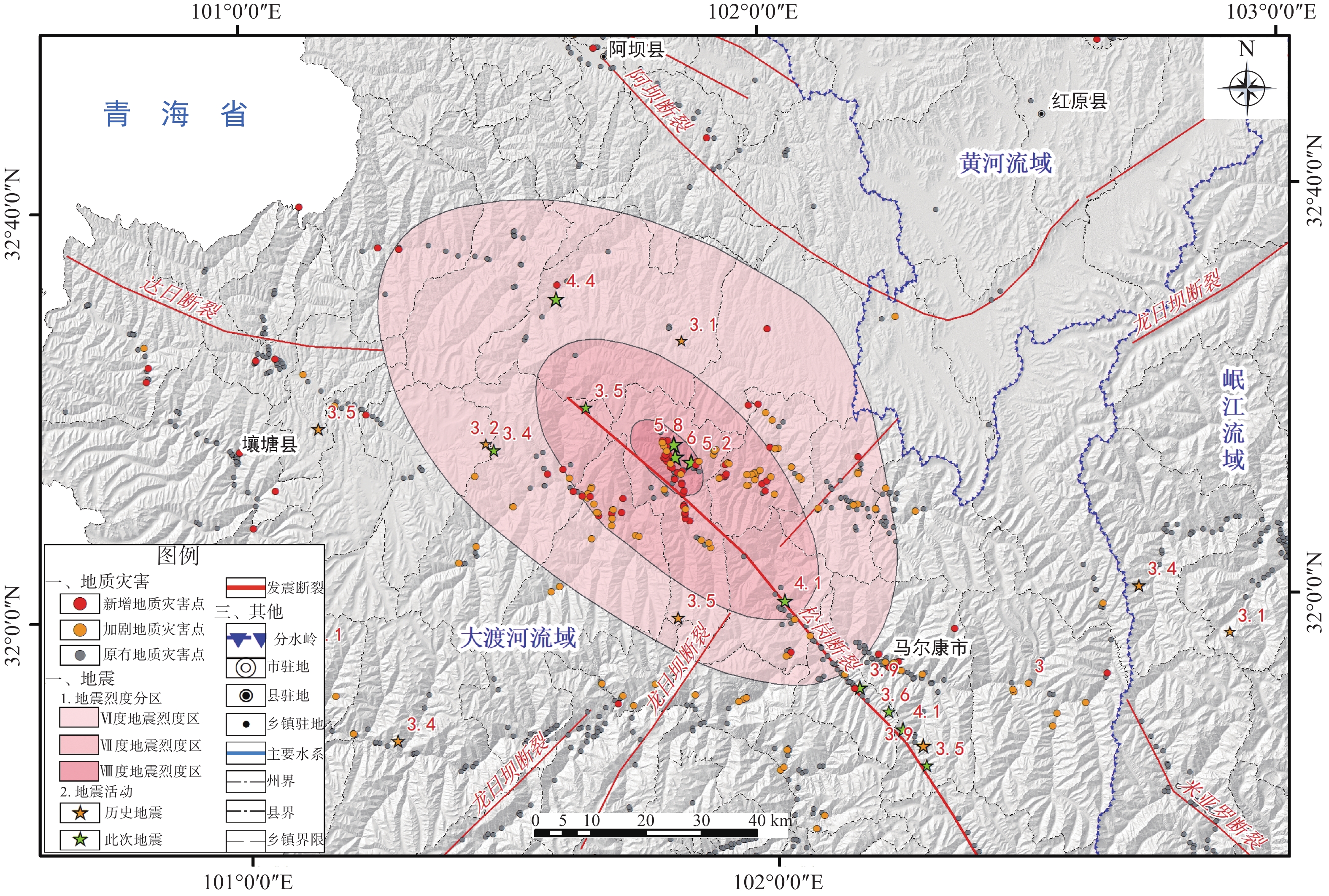
图 7 2022年6月10日马尔康MS6.0震群地震灾区地质灾害分布图(烈度分区数据来源:中国地震局官网
http://www.cea.gov.cn )Figure 7. Distribution map of geological disasters in the earthquake-stricken area of the Maerkang MS 6.0 earthquake swarm (Intensity zoning data source: China Earthquake Administration Official Website http://www.cea.gov.cn)
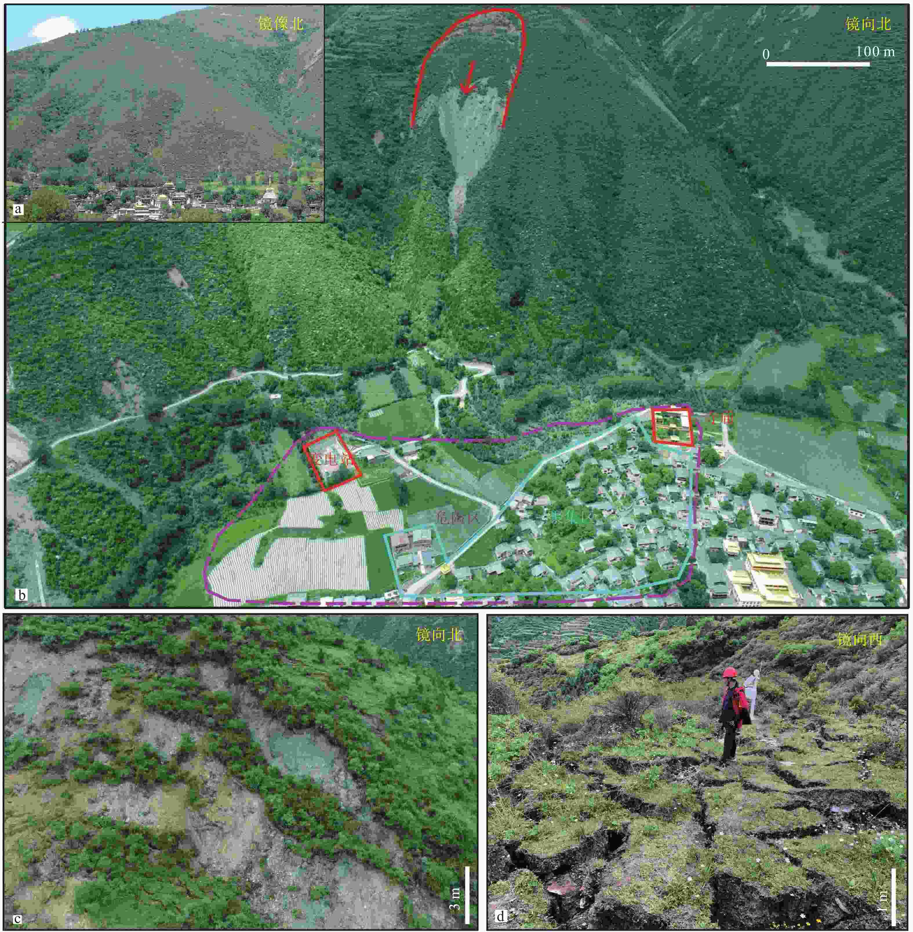
图 8 草登乡政府后山同震高位滑坡特征
a—草登乡政府后山全貌;b—滑坡全貌及危险区范围;c—滑坡后缘下错陡坎;d—滑坡后缘平台卸荷解体区
Figure 8. Characteristics of the co-seismic high-position landslide in the back hill of Caodeng Township Government
(a) Overview of the back hill of Caodeng Township Government; (b) Overview of the landslide and the hazardous zone; (c) Steep slope at the back edge of the landslide; (d) Unloading and disintegration area of the platform at the back edge of the landslide
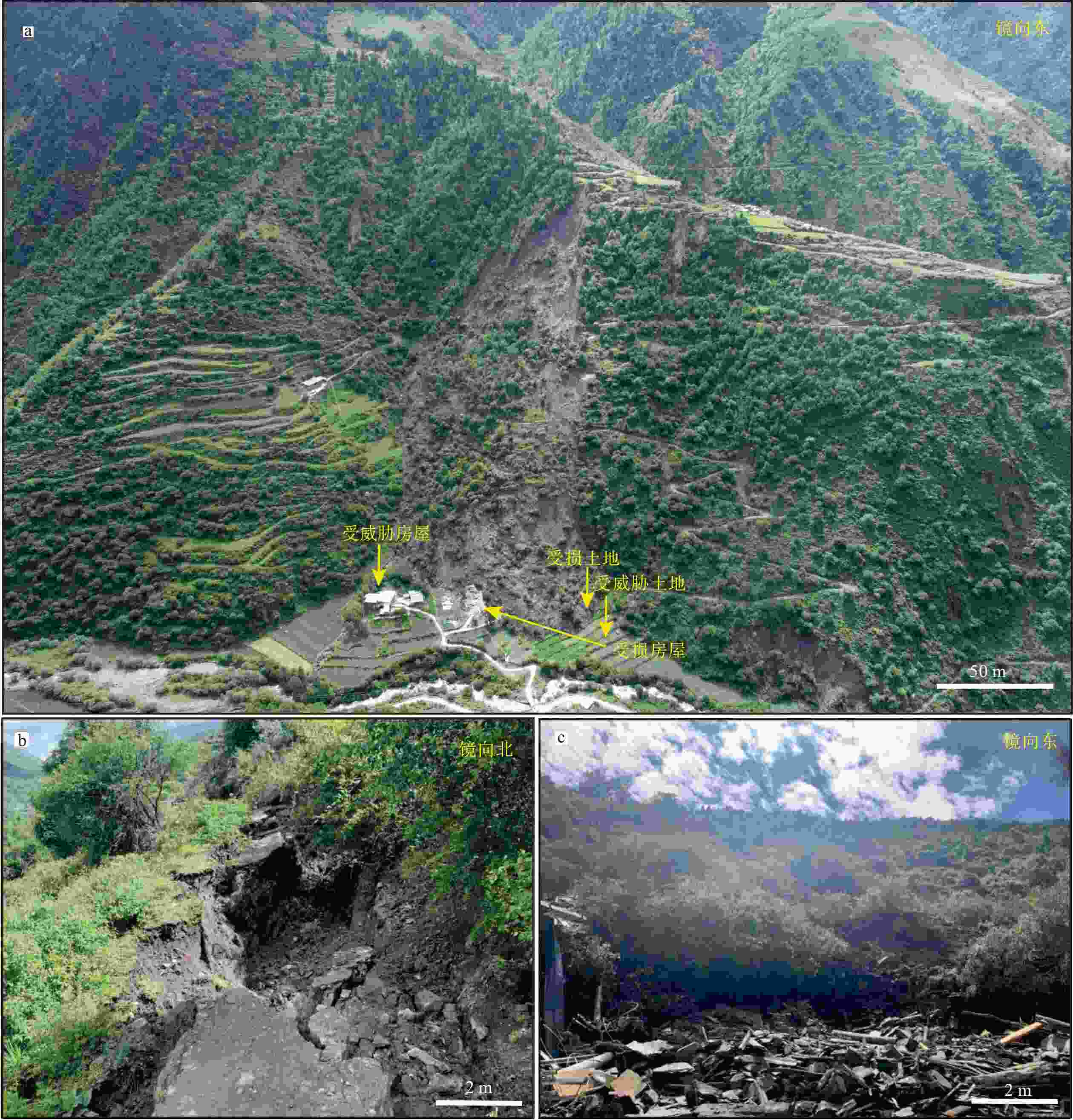
图 9 草登乡科拉机村俄热塘滑坡特征
a—滑坡全貌图;b—滑坡后缘下错裂缝;c—滑坡前缘
Figure 9. Characteristics of the Eretang landslide in Kelaji Village, Caodeng Town
(a) Overview of the landslide; (b) Cracks at the back edge of the landslide; (c) Front edge of the landslide
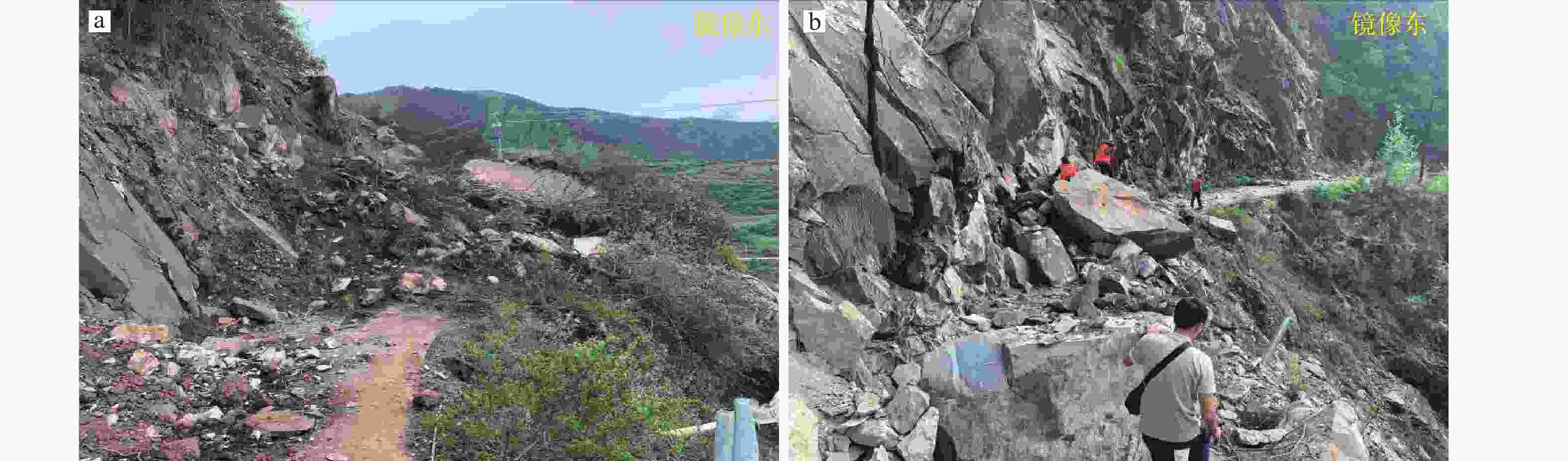
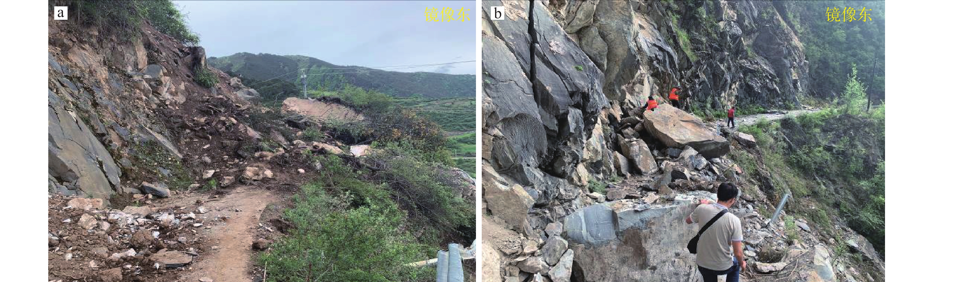
图 10 典型公路边坡崩塌(滑)体特征
a—典型松散堆积物崩滑体;b—典型基岩崩塌体
Figure 10. Photos showing characteristics of typical landslides at highway slopes
(a) Typical loose accumulation landslide; (b) Typical bedrock collapse
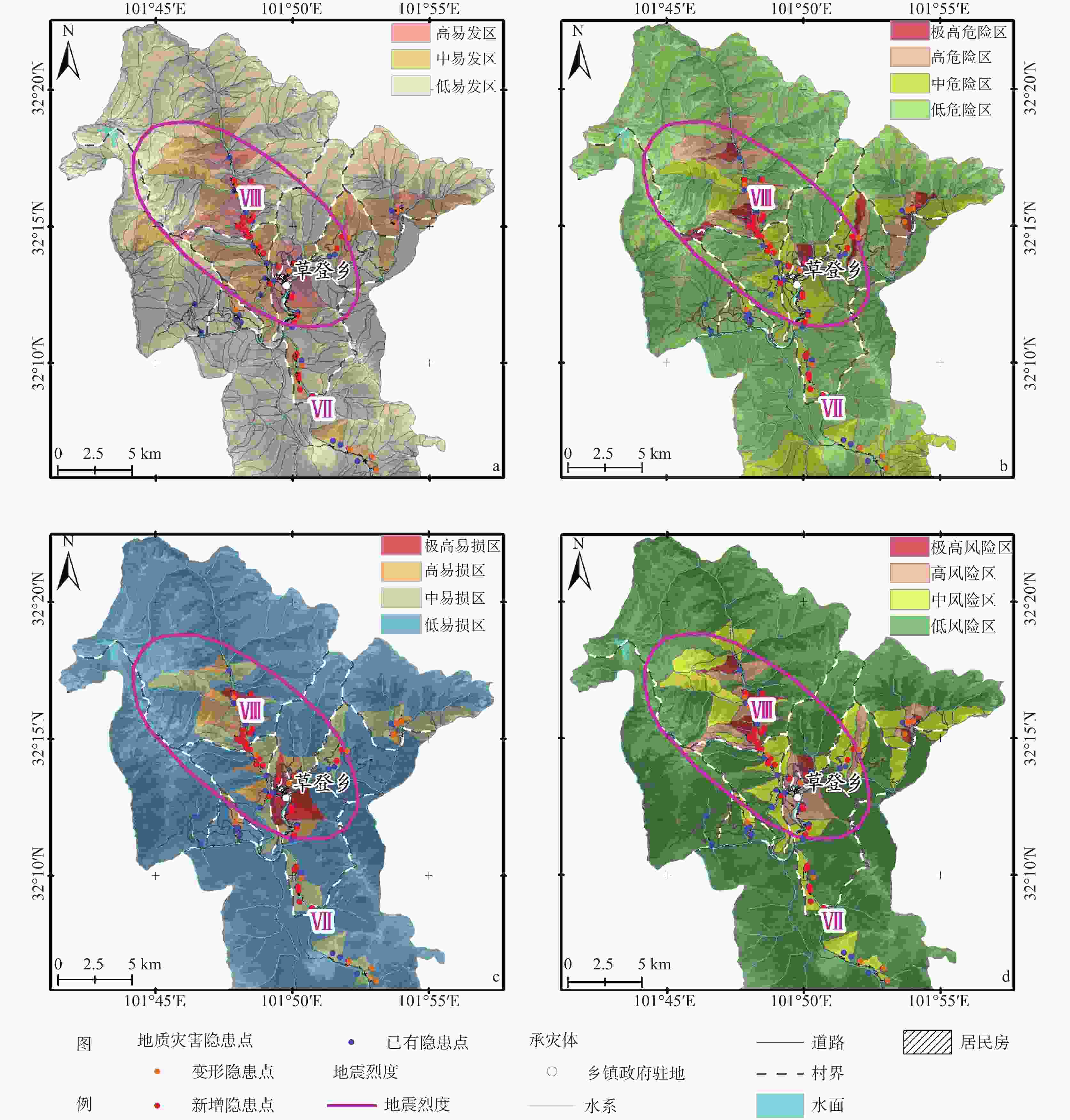
图 11 震中草登乡地质灾害评价图
a—灾害易发性;b—危险性;c—易损性;d—风险性
Figure 11. Geological hazard assessment maps of Caodeng Town
(a) Susceptibility assessment map; (b) Hazard assessment map; (c) Vulnerability assessment map; (d) Risk assessment map
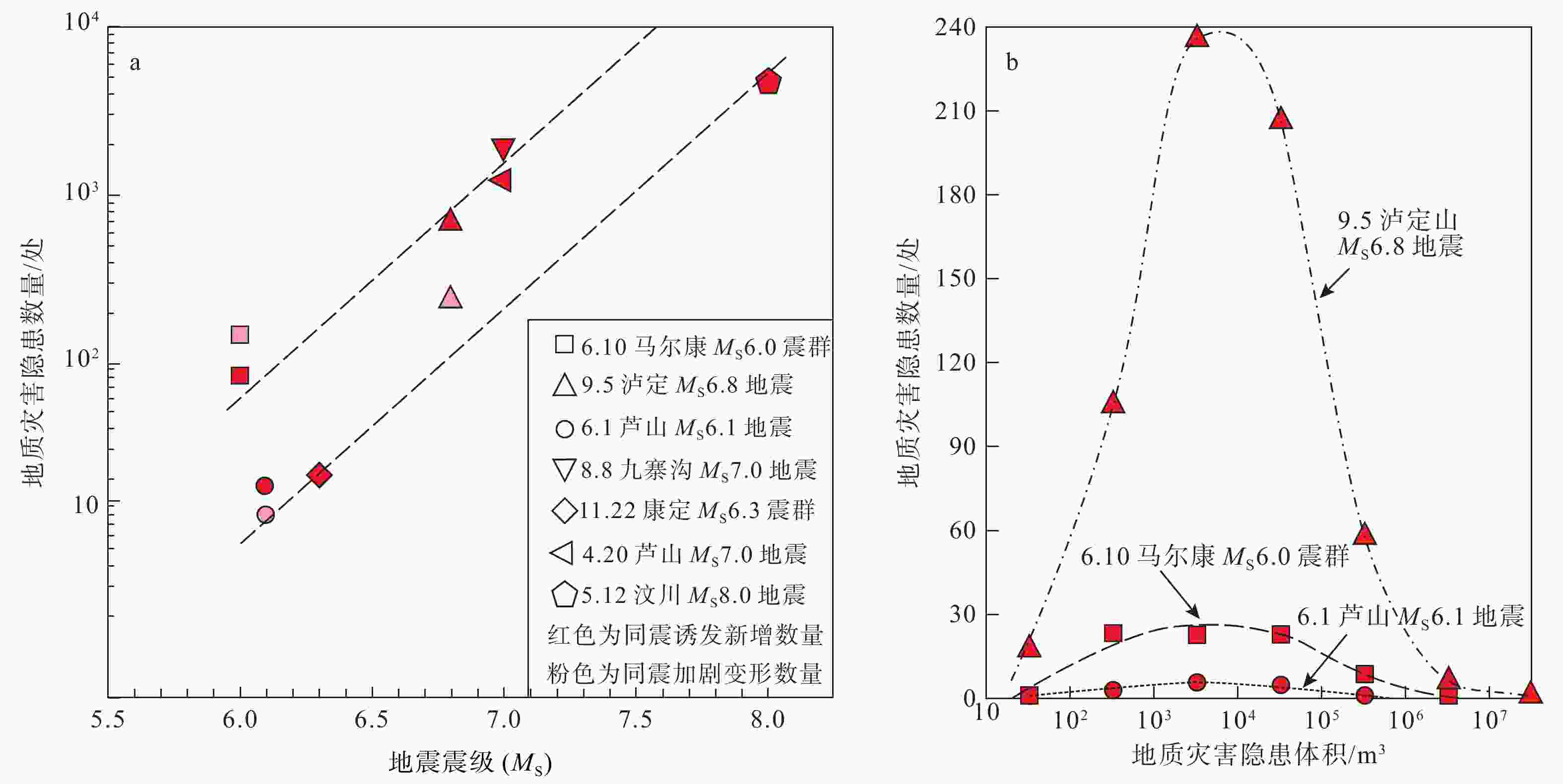
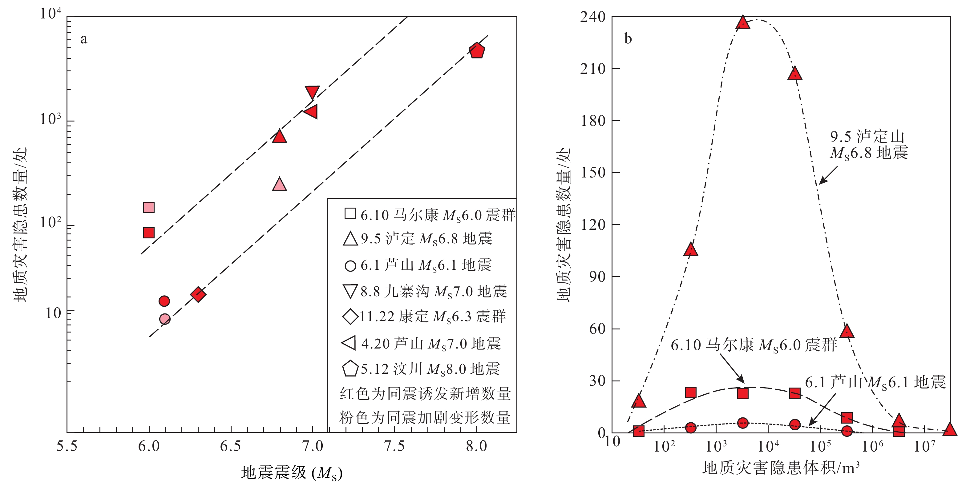
图 12 不同地震同震地质灾害对比图
a—不同地震震级与同震地质灾害数量关系;b—不同地震同震地质灾害体积与灾害数量关系
Figure 12. Comparison plots of co-seismic geological hazards caused by different earthquakes
(a) Relationship between different earthquake magnitudes and the number of co-seismic geological hazards; (b) Relationship between the volume of co-seismic geological hazards and the number of hazards
表 1 马尔康MS6.0级震群地震序列统计表
Table 1. Statistical table of the earthquake sequence of the Maerkang MS 6.0 earthquake swarm
统计时段 地震频次 总频次 最大震级(MS) MS 2.0~2.9 MS 3.0~3.9 MS 4.0~4.9 MS 5.0~5.9 MS 6.0~6.9 2022-06-09—2022-06-10 247 43 4 2 1 297 6.0 2022-06-11—2022-06-13 127 7 134 3.9 2022-06-14~2022-06-20 118 15 1 134 4.4 2022-06-21—2022-06-30 73 4 77 3.7  下载: 导出CSV
表 2 震后地质灾害数量分类统计
Table 2. Classification and statistics of post-earthquake geological disasters
县(市) 震前在库灾害点数/处 新增点/处 变形加剧点/处 灾种类型及数量/处 总威胁户数/户 总威胁人数/人 总威胁财产/万元 滑坡 崩塌 泥石流 马尔康市 316 63 96 177 23 179 3333 16030 145590 阿坝县 81 5 1 35 3 48 817 5835 44071 红原县 19 2 2 13 1 7 122 872 6970 壤塘县 164 13 7 72 16 89 1311 7508 90945 合计 580 83 106 297 43 323 5583 30245 287576
下载: 导出CSV
-
[1] AI Y F, ZHANG J, 2019. Geophysical analysis on the tectonic difference between northern and southern segments of Xianshuihe fault zone[J]. Acta Seismologica Sinica, 41(3): 329-342. (in Chinese with English abstract [2] BAI D H, UNSWORTH M J, MEIU M A, et al, 2010. Crustal deformation of the eastern Tibetan plateau revealed by magnetotelluric imaging[J]. Nature Geoscience, 3(5): 358-362. doi: 10.1038/ngeo830 [3] BAI M K, MARIE-LUCE C, LI H B, et al, 2022. Late quaternary slip rate and earthquake hazard along the Qianning segment, Xianshuihe fault[J]. Acta Geologica Sinica, 96(7): 2312-2332. (in Chinese with English abstract [4] BAI Y J, TIE Y B, MENG M J, et al, 2022. Characteristics and temporal-spatial distribution of geohazards in western Sichuan[J]. Sedimentary Geology and Tethyan Geology, 42(4): 666-674. (in Chinese with English abstract [5] CHEN C Y, REN J W, MENG G J, et al, 2013. Division, deformation and tectonic implication of active blocks in the eastern segment of Bayan Har block[J]. Chinese Journal of Geophysics, 56(12): 4125-4141. (in Chinese with English abstract [6] CHEN C Y, ZHAN W, ZHENG Z J, et al, 2022. Analyzing the tectonic deformation characteristics of the eastern part of the east Kunlun fault and its adjacent areas using GPS and leveling data[J]. Journal of Seismological Research, 45(1): 36-47. (in Chinese with English abstract [7] DAI L X, XU Q, FAN X M, et al, 2017. A preliminary study on spatial distribution patterns of landslides triggered by Jiuzhaigou earthquake in Sichuan on August 8th, 2017 and their susceptibility assessment[J]. Journal of Engineering Geology, 25(4): 1151-1164. (in Chinese with English abstract [8] DU M F, 2020. Location of small seismic essence in aba area and its active structural significance[D]. Chengdu: Chengdu University of Technology: 23-28. (in Chinese with English abstract [9] GUO X Y, GAO R, RANDYKELLER G, et al, 2014. Integrated geophysical study on the tectonic feature of the Longriba fault zone, eastern Tibetan Plateau, and the tectonic implications[J]. Progress in Geophysics, 29(5): 2004-2012. (in Chinese with English abstract [10] HAO M, WANG Q L, SHEN Z K, et al, 2014. Present day crustal vertical movement inferred from precise leveling data in eastern margin of Tibetan Plateau[J]. Tectonophysics, 632: 281-292. doi: 10.1016/j.tecto.2014.06.016 [11] HE J J, REN J J, DING R, et al, 2016. Late quaternary activity of the southern segment of Longriba fault zone in eastern Tibet and its tectonic implications[J]. Technology for Earthquake Disaster Prevention, 11(4): 707-721. (in Chinese with English abstract [12] HU Q L, WANG Y S, 2018. The susceptibility assessment of geological disasters in geomorphic transition zone based on GIS, western Sichuan, China[J]. Journal of Chengdu University of Technology (Science & Technology Edition), 45(6): 746-753. (in Chinese with English abstract [13] HUANG R Q, LI W L, 2008. Research on development and distribution rules of geohazards induced by Wenchuan earthquake on 12th May, 2008[J]. Chinese Journal of Rock Mechanics and Engineering, 27(12): 2585-2592. (in Chinese with English abstract [14] HUANG R Q, 2011. After effect of geohazards induced by the Wenchuan earthquake[J]. Journal of Engineering Geology, 19(2): 145-151. (in Chinese with English abstract [15] HUANG R Q, WANG Y S, PEI X J, et al, 2013. Characteristics of Co-seismic landslides triggered by the Lushan MS7.0 earthquake on the 20th of April, Sichuan province, China[J]. Journal of Southwest Jiaotong University, 48(4): 581-589. (in Chinese with English abstract [16] JIANG Y, WU Z H, LI J C, et al, 2014. The characteristics of landslides triggered by the Yushu MS 7.1 earthquake and its seismogeology implication[J]. Acta Geologica Sinica, 88(6): 1157-1176. (in Chinese with English abstract [17] KIRBY E, HARKINS N, WANG E Q, et al, 2007. Slip rate gradients along the eastern Kunlun fault[J]. Tectonics, 26(2): TC2010, doi: 10.1029/2006TC002033 [18] LI J J, ZHANG J L, CAI Y Y, 2017. investigation of historical earthquakes, Paleo-earthquakes and seismic gap in the Eastern Kunlun fault zone[J]. Earthquake, 37(1): 103-111. (in Chinese with English abstract [19] Wan S L, Zhang J L, Liu M J, et al, 2020. Seismic structure and seismic activity analysis of the Minshan fault block[J]. Earthquake, 40(02): 49-70. [20] LI J N, HAN Z J, LUO J H, et al, 2021. Characteristics and implications of seismic activity around Minshan active block in eastern margin of Qinghai-Tibet Plateau[J]. Seismology and Geology, 43(6): 1459-1484. (in Chinese with English abstract [21] LI T H, YUAN Y B, 2018. Risk assessment of secondary geological disasters induced in an earthquake-stricken area[J]. China Earthquake Engineering Journal, 40(1): 111-115. (in Chinese with English abstract [22] LI Y H, HAO M, JI L Y, et al, 2014. Fault slip rate and seismic moment deficit on major active faults in mid and south part of the Eastern margin of Tibet plateau[J]. Chinese Journal of Geophysics, 57(4): 1062-1078. (in Chinese with English abstract [23] LIANG M J, YANG Y, DU F, et al 2020. Re-investigation of the late Quaternary activity of the mid-segment of the Datong Fault in Qinghai and the surface rupture zone of the 1947 M7.3/4 earthquake. Seismology and Geology, 42(03): 703-714. [24] LIU L, LI Y J, ZHU L Y, et al, 2021. Influence of the 1947 Dari M7.7 earthquake on stress evolution along the boundary fault of the Bayan Har block: insights from numerical simulation[J]. Chinese Journal of Geophysics, 64(7): 2221-2231. (in Chinese with English abstract [25] SUN D, WANG D Y, WU D C, et al, 2010. Activity and effect of main faults in near field of Bala hydropower station in Maerkang[J]. Journal of Engineering Geology, 18(6): 940-949. (in Chinese with English abstract [26] SUN D, YANG T, CAO N, et al, 2023. Characteristics and mitigation of coseismic geohazards associated with the Luding MS6.8 earthquake[J]. Earth Science Frontiers, 30(3): 476-493. (in Chinese with English abstract [27] TAN Z Y, LUO X L, CHEN Y, et al, 2021. Risk assessment of high-level collapse and landslide disasters in typical basin-edge mountainous areas in northeast Chongqing: A case study of the Ningqiao area in Wuxi[J]. The Chinese Journal of Geological Hazard and Control, 32(5): 70-78. (in Chinese with English abstract [28] TIE Y B, ZHANG X Z, LU J Y, et al, 2022. Characteristics of geological hazards and it's mitigations of the MS6.8 earthquake in Luding County, Sichuan province[J]. Hydrogeology & Engineering Geology, 49(6): 1-12. (in Chinese with English abstract [29] VAN DER WOERD J, RYERSON F J, TAPPONNIER P, et al, 2000. Uniform slip-rate along the Kunlun Fault: implications for seismic behaviour and large-scale tectonics[J]. Geophysical Research Letters, 27(16): 2353-2356. doi: 10.1029/1999GL011292 [30] WANG C Y, HAN W B, WU J P, et al, 2003. Crustal structure beneath the Songpan-Garze orogenic belt[J]. Acta Seismologica Sinica, 25(3): 229-241. (in Chinese with English abstract [31] WANG D J, WANG D Z, ZHAO B, et al, 2022. 2021 Qinghai Madoi MW 7.4 earthquake coseismic deformation field and fault-slip distribution using GNSS observations[J]. Chinese Journal of Geophysics, 65(2): 537-551. (in Chinese with English abstract [32] WANG M, SHEN Z K, 2020. Present-day crustal deformation of continental China derived from GPS and its tectonic implications[J]. Journal of Geophysical Research: Solid Earth, 125(2): e2019JB018774, doi: 10.1029/2019jb018774 [33] WANG Y S, LUO Y H, JI F, et al, 2008. Analysis of the controlling factors on geo-hazards in mountainous epicenter zones of the Wenchuan earthquake[J]. Journal of Engineering Geology, 16(6): 759-763. (in Chinese with English abstract [34] WANG Z S, XIAO L Z, 1984. Characteristics of sequential activity of earthquake swarms[J]. Journal of Seismological Research, 7(6): 629-638. (in Chinese with English abstract [35] XIONG W, HUANG X L, WU Z H, et al, 2022. Damage characteristics and cause of MS 6.4 earthquake in Yangbi, Yunnan Province on May 21, 2021[J]. Geological Bulletin of China, 41(8): 1462-1472. (in Chinese with English abstract [36] XU F, 2018. Research on focal mechanism of 2014 Kangding M6.3 earthquake[J]. Journal of Institute of Disaster Prevention, 20(1): 70-74. (in Chinese with English abstract [37] XU X W, WEN X Z, ZHENG R Z, et al, 2003. Pattern of latest tectonic motion and its dynamics for active blocks in Sichuan-Yunnan region, China[J]. Science in China Series D: Earth Sciences, 46(S2): 210-226. doi: 10.1360/03dz0017 [38] XU X W, WEN X Z, CHEN G H, et al, 2008. Discovery of the Longriba fault zone in eastern Bayan Har block, China and its tectonic implication[J]. Science in China Series D: Earth Sciences, 51(9): 1209-1223. doi: 10.1007/s11430-008-0097-1 [39] YAN L J, LIU Y, LIAO S R, et al, 2022. Real-time automatic detection results for the Maerkang, Sichuan earthquake sequence on June 10, 2022[J]. China Earthquake Engineering Journal, 44(6): 1450-1458. (in Chinese with English abstract [40] YANG Z H, WU R A, GUO C B, et al, 2022. Geo-hazard effects and typical landslide characteristics of the Batang fault zone in the western Sichuan[J]. Geology in China, 49(2): 355-368. (in Chinese with English abstract [41] YI G X, Long F, Liang M J, et al, 2023. Seismic structure of the M_S6.8 earthquake sequence in Luding, Sichuan on September 5, 2022[J]. Chinese Journal of Geophysics, 66(04): 1363-1384. [42] YIN Y P, ZHANG Y S, MA Y S, et al, 2010. Research on major characteristics of geohazards induced by the Yushu MS 7.1 earthquake[J]. Journal of Engineering Geology, 18(3): 289-296. (in Chinese with English abstract [43] YIN Y P, WANG W P, ZHANG N, et al, 2017. Long runout geological disaster initiated by the ridge-top rockslide in a strong earthquake area: A case study of the Xinmo landslide in Maoxian County, Sichuan Province[J]. Geology in China, 44(5): 827-841. (in Chinese with English abstract [44] YIN Z Q, CHEN H Q, CHU H L, et al, 2013. Analysis on the key controlling factors of geo-hazards triggered by five typical earthquake events in China since 2008[J]. Earth Science Frontiers, 20(6): 289-302. (in Chinese with English abstract [45] ZHAN Y, LIANG M J, SUN X Y, et al, 2021. Deep structure and seismogenic pattern of the 2021.5. 22 Madoi (Qinghai) MS7.4 earthquake[J]. Chinese Journal of Geophysics, 64(7): 2232-2252. (in Chinese with English abstract [46] ZHANG D, WU Z H, LI J C, et al, 2013. An overview on earthquake-induced landslide research[J]. Journal of Geomechanics, 19(3): 225-241. (in Chinese with English abstract [47] ZHANG J Y, DAI D Q, YANG Z G, et al, 2022. Preliminary analysis of emergency production and source parameters of the M6.0 earthquake on June 10, 2022 in Maerkang city, Sichuan Province[J]. Earthquake Research in China, 38(2): 370-382. (in Chinese with English abstract [48] ZHOU R J, HE Y L, MA S H, et al, 1999. Late quaternary active characteristics of Fubianhe fault in Sichuan’s Xiaojin[J]. Journal of Seismological Research, 22(4): 376-381. (in Chinese with English abstract [49] ZHOU R J, LI Y, ALEXANDER L D, et al, 2006. Active tectonics of the eastern margin of the Tibet plateau[J]. Journal of Mineralogy and Petrology, 26(2): 40-51. (in Chinese with English abstract [50] 艾依飞,张健,2019. 鲜水河断裂带南北构造差异性的地球物理分析[J]. 地震学报,41(3):329-342. [51] 白明坤,MARIE-LUCE C,李海兵,等,2022. 鲜水河断裂带乾宁段晚第四纪走滑速率及区域强震危险性研究[J]. 地质学报,96(7):2312-2332. [52] 白永健,铁永波,孟铭杰,等,2022. 川西地区地质灾害发育特征与时空分布规律[J]. 沉积与特提斯地质,42(4):666-674. [53] 陈长云,任金卫,孟国杰,等,2013. 巴颜喀拉块体东部活动块体的划分、形变特征及构造意义[J]. 地球物理学报,56(12):4125-4141. [54] 陈长云,占伟,郑智江,等,2022. 利用GPS和水准数据分析东昆仑断裂带东部及其邻区构造变形特征[J]. 地震研究,45(1):36-47. [55] 戴岚欣,许强,范宣梅,等,2017. 2017年8月8日四川九寨沟地震诱发地质灾害空间分布规律及易发性评价初步研究[J]. 工程地质学报,25(4):1151-1164. [56] 杜明甫,2020. 阿坝地区小震精定位及其活动构造意义[D]. 成都:成都理工大学:23-28. [57] 郭晓玉,高锐,RANDYKELLER G,等,2014. 综合地球物理资料揭示青藏高原东缘龙日坝断裂带构造属性和大地构造意义[J]. 地球物理学进展,29(5):2004-2012. [58] 何建军,任俊杰,丁锐,等,2016. 青藏高原东缘龙日坝断裂带南段晚第四纪活动及其构造意义[J]. 震灾防御技术,11(4):707-721. [59] 胡芹龙,王运生,2018. 基于GIS的川西地貌过渡带滑坡灾害易发性评价[J]. 成都理工大学学报(自然科学版),45(6):746-753. [60] 黄润秋,李为乐,2008. “5.12”汶川大地震触发地质灾害的发育分布规律研究[J]. 岩石力学与工程学报,27(12):2585-2592. [61] 黄润秋,2011. 汶川地震地质灾害后效应分析[J]. 工程地质学报,19(2):145-151. [62] 黄润秋,王运生,裴向军,等,2013. 4·20芦山MS7.0级地震地质灾害特征[J]. 西南交通大学学报,48(4):581-589. [63] 蒋瑶,吴中海,李家存,等,2014. 2010年玉树7.1级地震诱发滑坡特征及其地震地质意义[J]. 地质学报,88(6):1157-1176. [64] 李建军,张军龙,蔡瑶瑶,2017. 东昆仑断裂带历史地震、古地震及地震空区讨论[J]. 地震,37(1):103-111. [65] 万森林,张军龙,刘明军,等,2020. 岷山断块的发震构造与地震活动性分析[J]. 地震,40(02):49-70. [66] 李佳妮,韩竹军,罗佳宏,等,2021. 青藏高原东缘岷山活动地块周缘的地震活动特征与启示[J]. 地震地质,43(6):1459-1484. [67] 李天华,袁永博,2018. 地震重灾区诱发次生地质灾害风险评价研究[J]. 地震工程学报,40(1):111-115. [68] 李煜航,郝明,季灵运,等,2014. 青藏高原东缘中南部主要活动断裂滑动速率及其地震矩亏损[J]. 地球物理学报,57(4):1062-1078. doi: 10.6038/cjg20140405 [69] 梁明剑,杨耀,杜方,等,2020. 青海达日断裂中段晚第四纪活动性与1947年M73/4地震地表破裂带再研究[J]. 地震地质,42(03):703-714. [70] 刘雷,李玉江,朱良玉,等,2021. 1947年达日M7.7地震对巴颜喀拉块体边界断裂应力影响的数值模拟[J]. 地球物理学报,64(7):2221-2231. [71] 孙东,王道永,吴德超,等,2010. 马尔康巴拉水电站近场区主要断裂活动性及对工程的影响[J]. 工程地质学报,18(6):940-949. doi: 10.3969/j.issn.1004-9665.2010.06.020 [72] 孙东,杨涛,曹楠,等,2023. 泸定MS6.8地震同震地质灾害特点及防控建议[J]. 地学前缘,30(3):476-493. [73] 谭真艳,罗晓龙,陈怡,等,2021. 渝东北典型盆缘山区高位崩滑灾害风险评价:以巫溪县宁桥片区为例[J]. 中国地质灾害与防治学报,32(5):70-78. [74] 铁永波,张宪政,卢佳燕,等,2022. 四川省泸定县MS6.8级地震地质灾害发育规律与减灾对策[J]. 水文地质工程地质,49(6):1-12. [75] 王椿镛,韩渭宾,吴建平,等,2003. 松潘-甘孜造山带地壳速度结构[J]. 地震学报,25(3):229-241. doi: 10.3321/j.issn:0253-3782.2003.03.001 [76] 王迪晋,王东振,赵斌,等,2022. 2021年青海玛多MW7.4地震GNSS同震形变场及其断层滑动分布[J]. 地球物理学报,65(2):537-551. doi: 10.6038/cjg2022P0568 [77] 王运生,罗永红,吉峰,等,2008. 汶川大地震山地灾害发育的控制因素分析[J]. 工程地质学报,16(6):759-763. doi: 10.3969/j.issn.1004-9665.2008.06.005 [78] 王振声,肖丽珠,1984. 震群型序列活动特征[J]. 地震研究,7(6):629-638. [79] 熊伟,黄小龙,吴中海,等,2022. 2021年5月21日云南漾濞MS 6.4地震震害特征及成因[J]. 地质通报,41(8):1462-1472. doi: 10.12097/j.issn.1671-2552.2022.08.012 [80] 徐峰,2018. 2014年11月22日康定M6.3地震震源机制研究[J]. 防灾科技学院学报,20(1):70-74. doi: 10.3969/j.issn.1673-8047.2018.01.009 [81] 徐锡伟,闻学泽,郑荣章,等,2003. 川滇地区活动块体最新构造变动样式及其动力来源[J]. 中国科学(D辑),33(S1):151-162. [82] 徐锡伟,闻学泽,陈桂华,等,2008. 巴颜喀拉地块东部龙日坝断裂带的发现及其大地构造意义[J]. 中国科学 D辑:地球科学,38(5):529-542. [83] 颜利君,刘媛,廖诗荣,等,2022. 2022年6月10日四川马尔康地震序列实时智能检测结果分析与研究[J]. 地震工程学报,44(6):1450-1458. [84] 杨志华,吴瑞安,郭长宝,等,2022. 川西巴塘断裂带地质灾害效应与典型滑坡发育特征[J]. 中国地质,49(2):355-368. [85] 易桂喜,龙锋,梁明剑,等,2023. 2022年9月5日四川泸定M_S6.8地震序列发震构造[J]. 地球物理学报,66(04):1363-1384. [86] 殷跃平,张永双,马寅生,等,2010. 青海玉树MS7.1级地震地质灾害主要特征[J]. 工程地质学报,18(3):289-296. doi: 10.3969/j.issn.1004-9665.2010.03.001 [87] 殷跃平,王文沛,张楠,等,2017. 强震区高位滑坡远程灾害特征研究:以四川茂县新磨滑坡为例[J]. 中国地质,44(5):827-841. doi: 10.12029/gc20170501 [88] 殷志强,陈红旗,褚宏亮,等,2013. 2008年以来中国5次典型地震事件诱发地质灾害主控因素分析[J]. 地学前缘,20(6):289-302. [89] 詹艳,梁明剑,孙翔宇,等,2021. 2021年5月22日青海玛多MS7.4地震深部环境及发震构造模式[J]. 地球物理学报,64(7):2232-2252. doi: 10.6038/cjg2021O0521 [90] 张铎,吴中海,李家存,等,2013. 国内外地震滑坡研究综述[J]. 地质力学学报,19(3):225-241. doi: 10.3969/j.issn.1006-6616.2013.03.001 [91] 张建勇,戴丹青,杨志高,等,2022. 2022年6月10日四川马尔康6.0级地震应急产品及震源参数初步分析[J]. 中国地震,38(2):370-382. doi: 10.3969/j.issn.1001-4683.2022.02.017 [92] 周荣军,何玉林,马声浩,等,1999. 四川小金抚边河断裂的晚第四纪活动特征[J]. 地震研究,22(4):376-381. [93] 周荣军,李勇,ALEXANDER L D,等,2006. 青藏高原东缘活动构造[J]. 矿物岩石,26(2):40-51. doi: 10.3969/j.issn.1001-6872.2006.02.007 -

 下载:
下载:


计量
- 文章访问数: 3258
- HTML全文浏览量: 494
- PDF下载量: 101
- 被引次数: 0
