

Geological and evolutionary characteristics of the Gagarin Region on the far side of the Moon
-
摘要: 以月球背面加加林地区为研究对象,采用多源遥感数据解译,通过地质要素定量统计、分布特征与成因分析等研究方法,揭示了月球背面典型区域的地质特征,进而探讨了加加林地区区域地质演化历史,初步建立了该区地质特征与月球演化过程之间的联系。 研究结果表明:区内发育的全月最长深部断裂的形成为南极艾肯撞击事件与月球热膨胀等内外应力共同作用的结果;自南极−艾肯盆地向外延伸的多处月壳厚度的线性异常延伸至月球正面各大盆地,说明在月球深部,月球背面南极−艾肯盆地的影响范围可以辐射到月球正面单元;月球背面加加林地区撞击坑数量与面积的变化规律与月球所处的地月系及太阳系演化进程有关;撞击坑定量统计结果及玄武岩单元定年结果表明,艾肯纪至雨海纪是加加林地区外动力地质作用的活跃时期,雨海纪是其内动力地质作用的活跃时期。Abstract:
Objective This study focuses on the Gagarin region on the far side of the Moon, aiming to reveal the geological characteristics, distribution features, and genesis of typical areas on the lunar far side. Additionally, it seeks to explore the regional geological evolution history of the Gagarin region. Methods The study primarily employs methods such as multi-source remote sensing data interpretation, regional geological mapping, and quantitative analysis of geological elements' quantity and distribution characteristics. Results (1) 656 impact craters were discovered in the study area, of which 552 have diameters greater than 20 kilometers. Approximately 71.5% of the Gagarin region is covered by ancient basins and their ejecta from the Aitken period. Based on comprehensive area and diameter data, the Aitken period is identified as the geological era with the largest proportion of large impact craters (diameter greater than 70 kilometers) and the largest average diameter. From the Aitken period to the Copernican period, the total area of impact craters in each geological era shows a decreasing trend from old to new. (2) In the study area, six parallel lunar grabens, 62 lobate scarps, one sinuous rille , 50 crater floor fractures, and 70 shallow faults were discovered. It also includes parts of the two longest inferred deep faults on the Moon, originating from the South Pole–Aitken tectonic zone and almost spanning the entire highland tectonic zone. According to Bouguer gravity anomalies and crustal thickness data, linear crustal thickness anomalies extending outward from the South Pole–Aitken basin reach the major basins on the near side of the Moon. (3) The Gagarin region is primarily located in the anorthositic highlands on the far side of the Moon. The rocks mainly consist of ferroan anorthosite (fa) suites, with some crater floors showing magnesium anorthosite (ma) suites. In the central and southern parts of the Gagarin region, low-titanium (TiO2 > 1.5 and < 4.5) and very low-titanium (TiO2 < 1.5) basalts are sparsely distributed on the floors of certain impact craters and basins. (4) For this study, we selected impact craters such as Aitken and Van der Graaf, with diameters ranging from 350 to 1400 m, for dating analysis. The results of crater size-frequency distribution dating indicate ages of 3.47 GA and 3.32 GA, respectively. (5) The quantitative statistics of impact craters and the dating results of basalt units indicate that the Aitkenian to Imbrian periods were active periods of external dynamic geological processes in the Gagarin region, while the Imbrian period was an active period of internal dynamic geological processes. Conclusion (1) The region’s longest and deepest faults are the result of the combined effects of the South Pole–Aitken impact event and internal and external stresses, including lunar thermal expansion. (2) The variations in the number and size of impact craters in the Gagarin region on the far side of the Moon are related to the evolution of the Earth–Moon system and the solar system. (3) Based on the quantitative statistical results of impact craters and the dating results of basalt units, this study elucidates the regional geological evolution history, and different stages of the geological processes in the Gagarin region were divided according to the active periods and stage characteristics of internal and external dynamic geological processes. Significance The study revealed the geological features of key areas on the far side of the moon, delving into the geological history of the Gagarin region and tentatively establishing a correlation between its geological traits and the lunar evolutionary history. -
Key words:
- Lunar geology /
- Gagarin Basin /
- multi-source remote sensing data /
- geological evolution
-
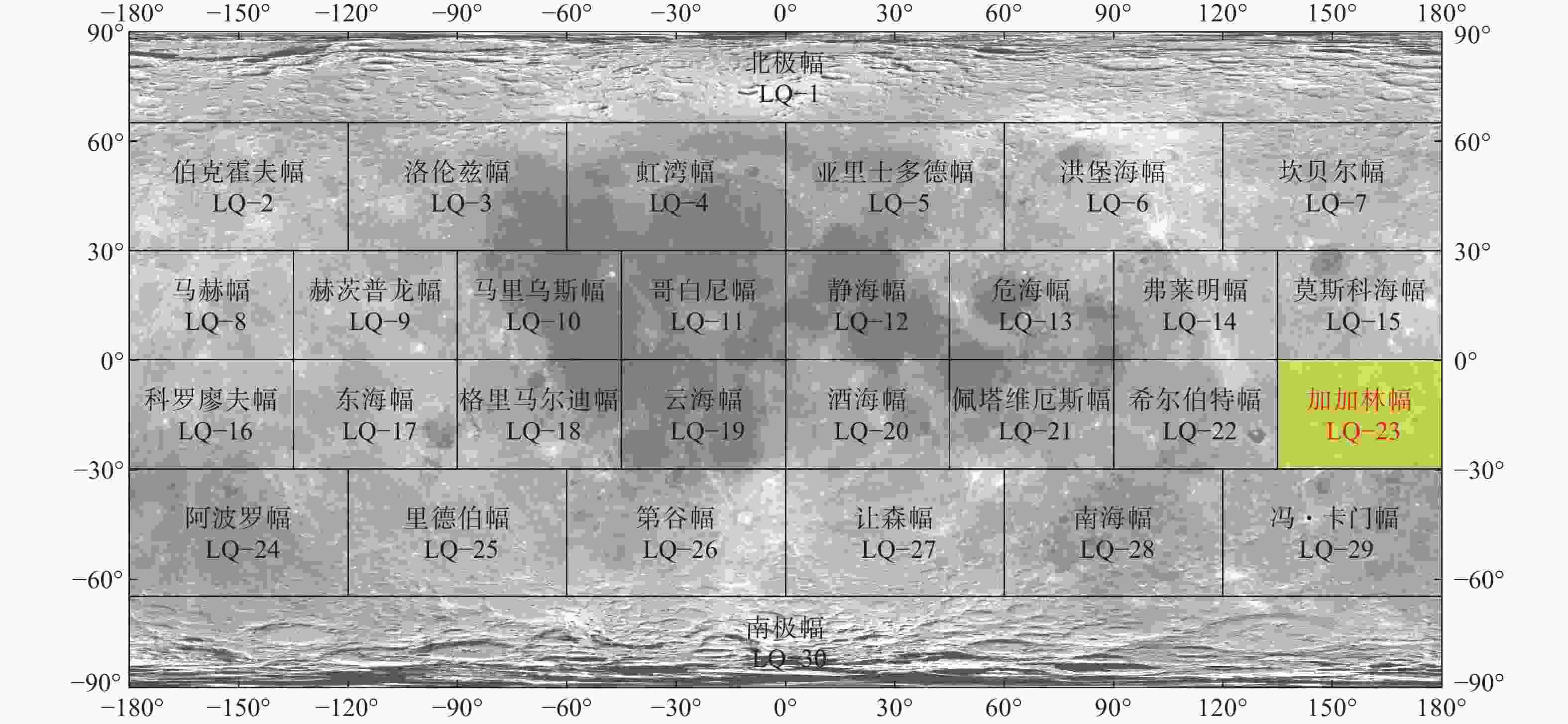
图 1 1∶250万月球地质图分幅及加加林地区位置示意图(底图为CE-1 CCD影像数据,分辨率为120 m;数据来源月球与行星数据发布系统
https://moon.bao.ac.cn/ ;图中经纬度注记中无负号代表东经经度和北纬纬度,有负号为西经经度和南纬纬度,如−30°代指南纬30°,150°代表东经150°,下同)Figure 1. The map sheet of the 1∶2500000 geological map of the moon and the position of the Gagarin region (Base map is CE-1 CCD image data, with a resolution of 120 m; data source: Moon and Planetary Data System https://moon.bao.ac.cn/; In the latitude and longitude annotation in the figure, no negative sign represents north latitude, and a negative sign represents south latitude, such as –30° indicating 30° south latitude, the same below.)
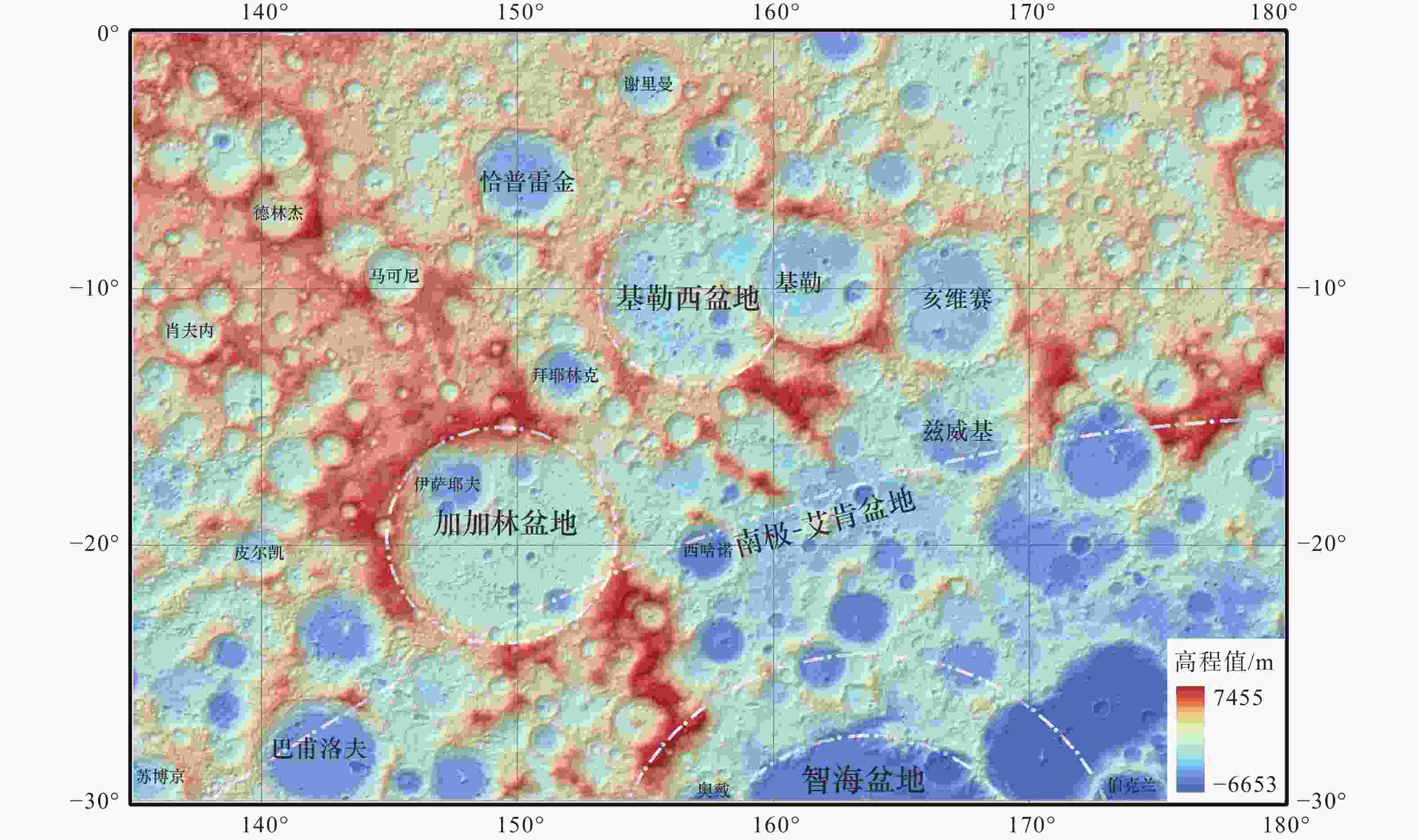
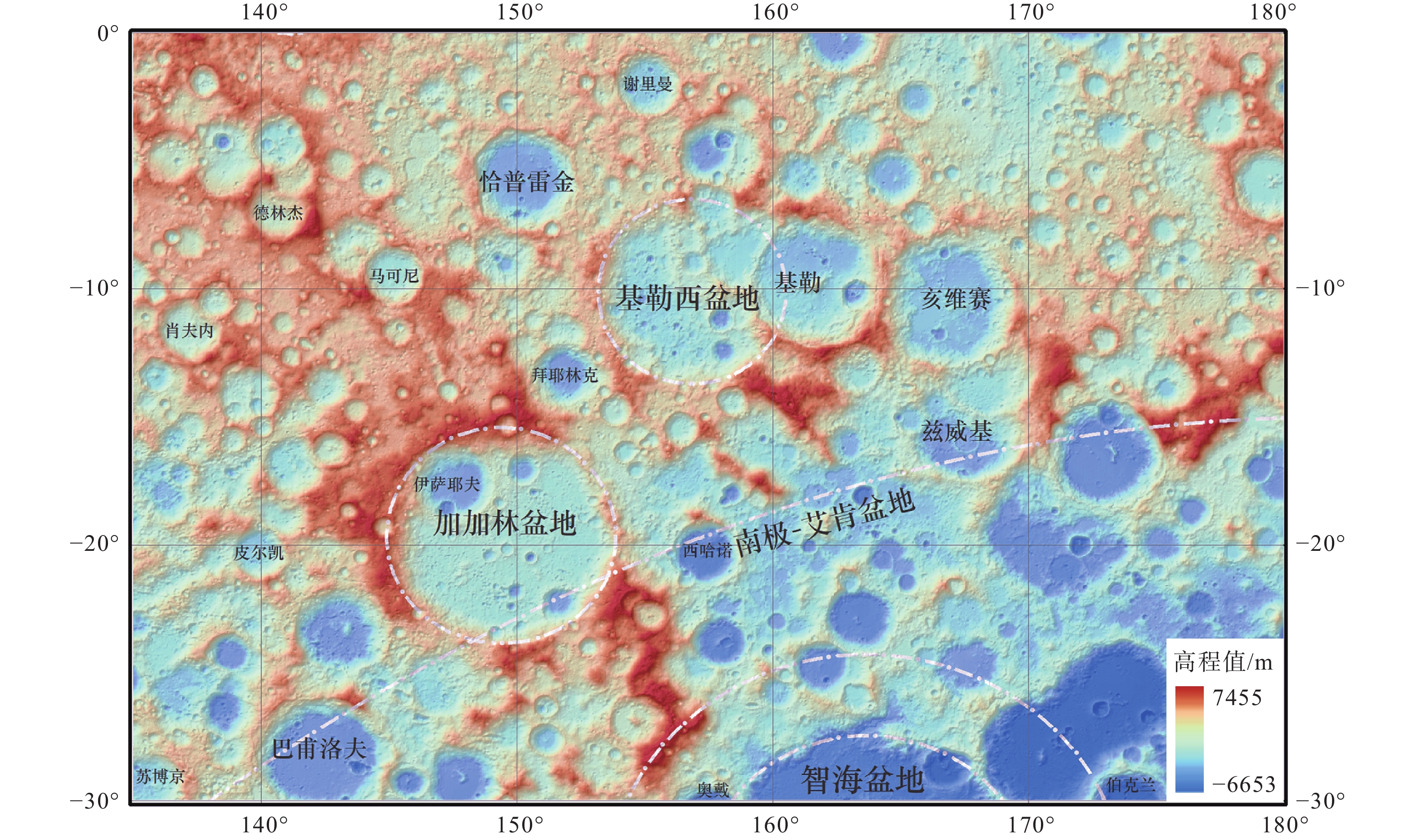
图 2 加加林地区地貌示意图(底图为LOLA高程数据;数据来源NASA官网
https://disc.gsfc.nasa.gov/ )Figure 2. Topographic schematic map of the Gagarin region (Base map is LOLA elevation data; data source: NASA official webbsite
https://disc.gsfc.nasa.gov/ )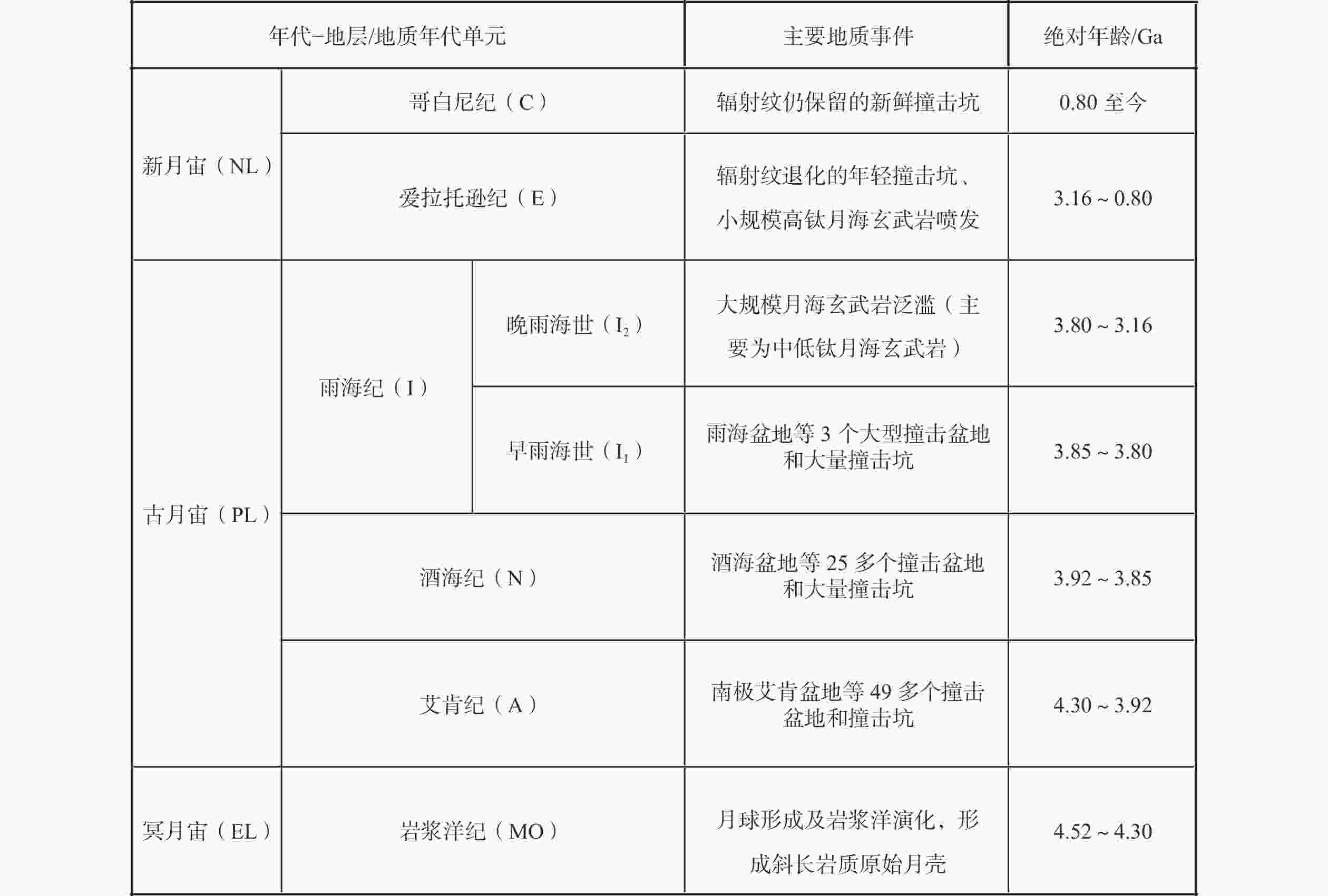
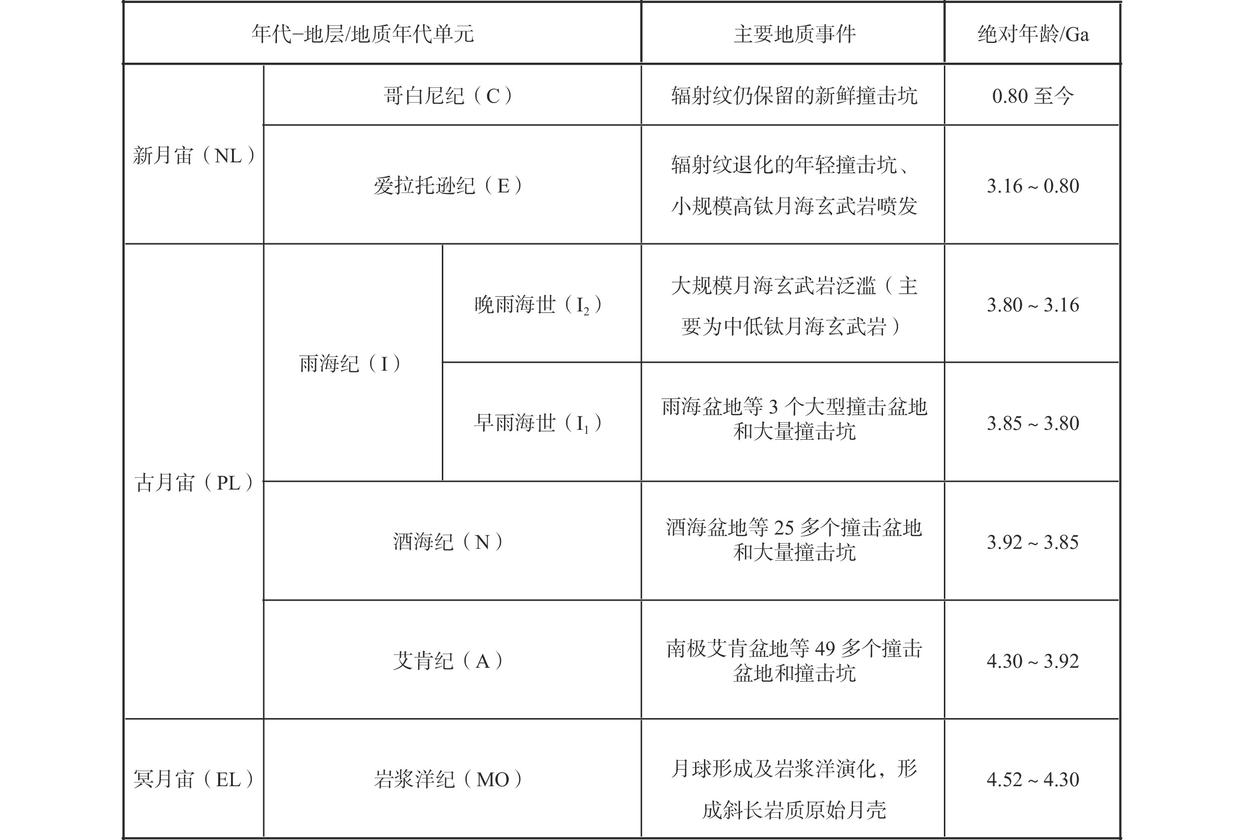
图 4 月球地质年代划分方案(据郭弟均等,2014;凌宗成等,2014修改)
Figure 4. Geologic chronology of the moon (modified after Guo et al., 2014; Ling et al., 2014 )
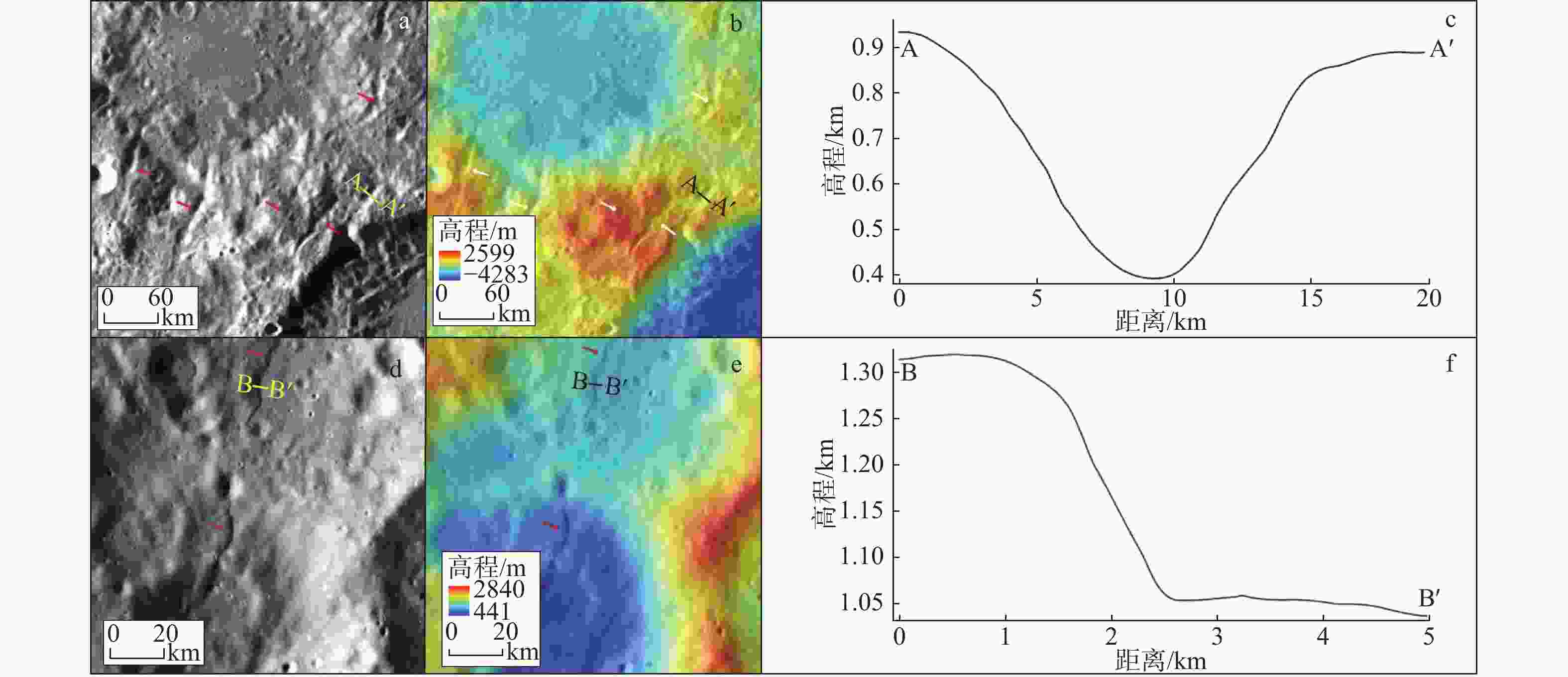
图 7 加加林地区月堑、叶状陡坎解译结果
a—部分月堑分布位置(底图为 WAC 影像,其中AA′为月堑剖面线,箭头指示月堑位置);b—对应区域高程图(底图为 LOLA 数据和 WAC影像数据叠加,箭头指示月堑位置);c—AA′剖面线对应地形剖面;d—部分叶状陡坎分布位置(底图为WAC 影像,其中BB′为叶状陡坎剖面线,箭头指示叶状陡坎位置);e—叶状陡坎分布区域高程图(底图为 LOLA 数据和 WAC影像数据叠加,箭头指示叶状陡坎位置);f—BB′剖面线对应地形剖面
Figure 7. Interpretation results of lunar grabens and lobate scarps in the Gagarin region
(a) Partial distribution map of lunar grabens (Base map is WAC image, where AA′ represents the section line of lunar grabens, with arrows indicating the position of lunar grabens); (b) Elevation map of the corresponding region (Base map is superimposed by LOLA data and WAC image data); (c) Topographic section corresponding to the section line AA′; (d) Partial distribution map of lobate scarps (Base map is WAC image, where BB′ represents the section line of lobate scarps, with arrows indicating the position of lobate scarps); (e) Elevation map of the lobate scarp distribution area (Base map is superimposed by LOLA data and WAC image data, with arrows indicating the position of lobate scarps); (f) Topographic section corresponding to the section line BB′
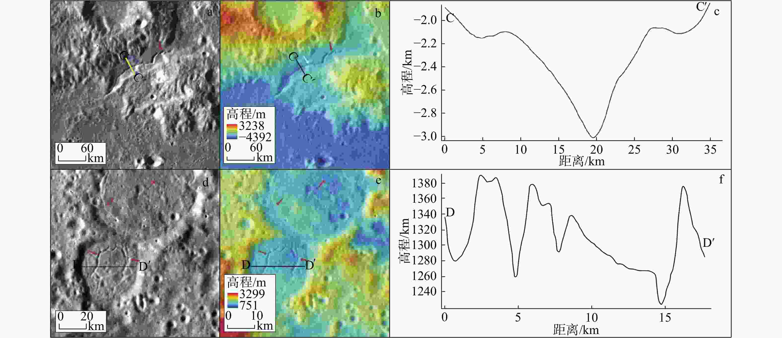
图 8 加加林地区月溪、坑底断裂解译结果
a—研究区内部分月溪分布位置(底图为 WAC 影像,其中CC'为月溪剖面线,箭头指示月溪位置);b—对应区域高程图(底图为 LOLA 数据和 WAC影像数据叠加);c—CC'剖面线对应地形剖面;d—部分坑底断裂分布位置(底图为 WAC 影像,其中DD'为坑底断裂剖面线);e—坑底断裂分布区域高程图(底图为 LOLA 数据和 WAC影像数据叠加);f—DD'剖面线对应地形剖面
Figure 8. Interpretation results of sinuous rilles and crater-floor fractures in the Gagarin map
(a) Partial distribution map of the sinuous rille (Base map is WAC image, where CC′ represents the section line of the sinuous rille, with arrows indicating the position of the sinuous rille); (b) Elevation map of the corresponding region (Base map is superimposed by LOLA data and WAC image data); (c) Topographic section corresponding to the section line CC'; (d) Partial distribution map of crater-floor fractures (Base map is WAC image, where DD′ represents the section line of crater-floor fractures); (e) Elevation map of the crater-floor fracture distribution area (Base map is superimposed by LOLA data and WAC image data); (f) Topographic section corresponding to the section line DD'

图 9 南极−艾肯盆地及邻区布格重力异常与月壳厚度(布格重力数据来自 GRAIL任务发布的 1200 阶布格异常模型,Goossens et al.,2020;月壳厚度数据使用GL0420A重力场模型计算得到,Wieczorek et al.,2013)
Figure 9. Bouguer gravity anomaly and lunar shell thickness of the South Pole–Aiken Basin and adjacent areas (The Bouguer gravity data is derived from the 1200-order Bouguer anomaly model published by the GRAIL mission from Goossens et al., 2020; The lunar shell thickness data are derived from the lunar shell thickness model calculated by Wieczorek et al. using GL0420A gravitational field model. Data source: Wieczorek et al., 2013)
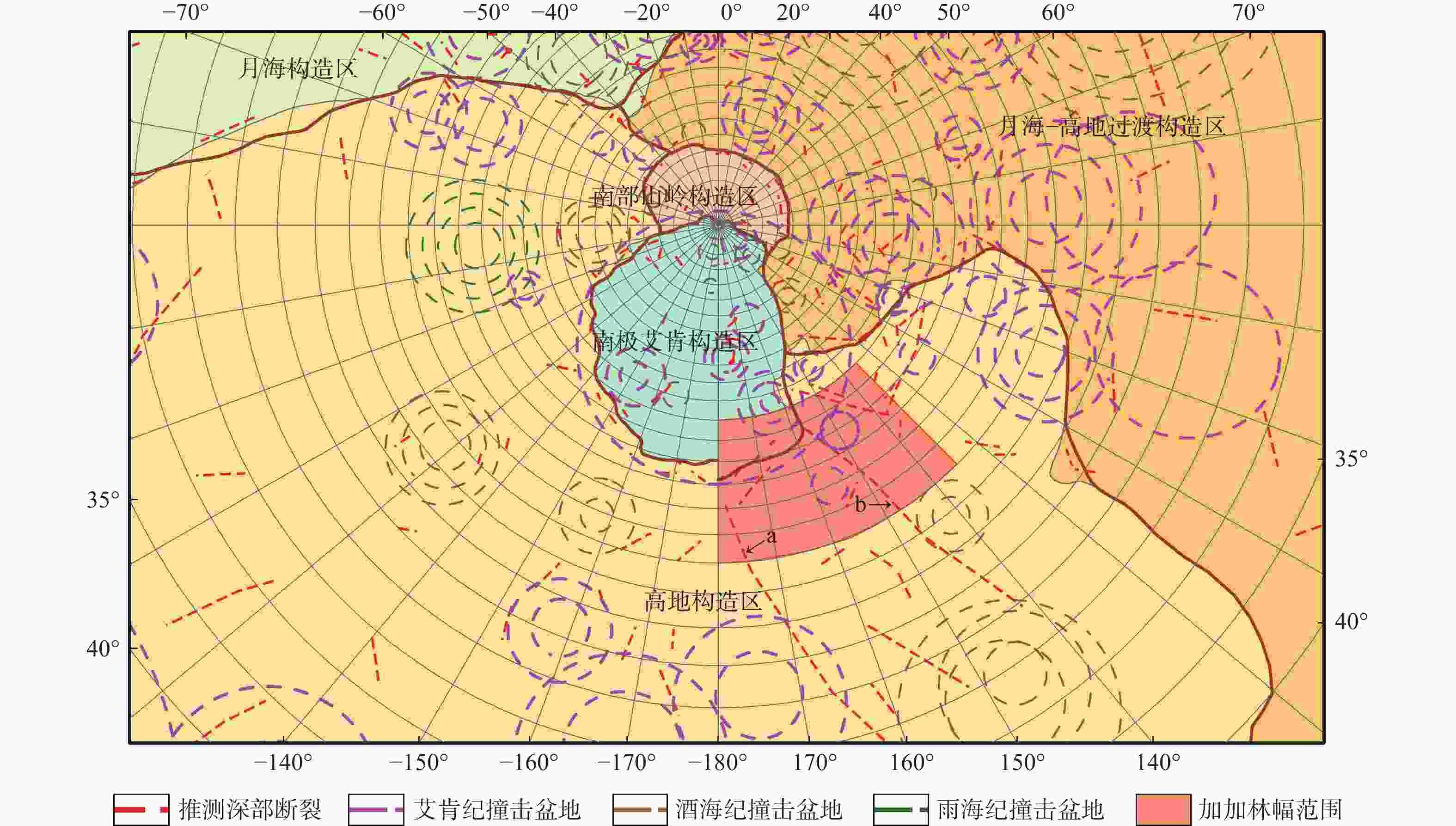
图 10 月球推测深部断裂识别结果及主要撞击盆地位置
a、b为全月最长的2条推测深部断裂的组成部分
Figure 10. Recognition results of inferred deep faults and location of main impact basins on the Moon
a and b are the components of the two longest inferred deep faults on the moon.
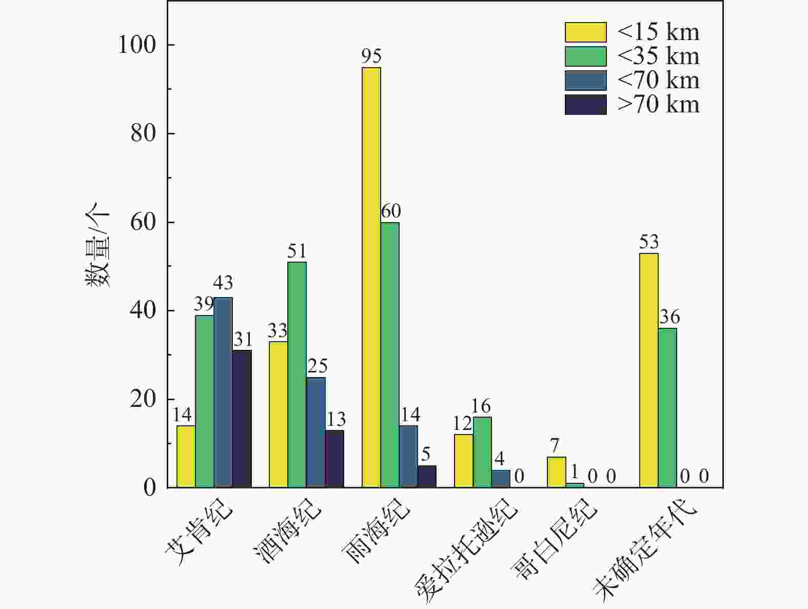
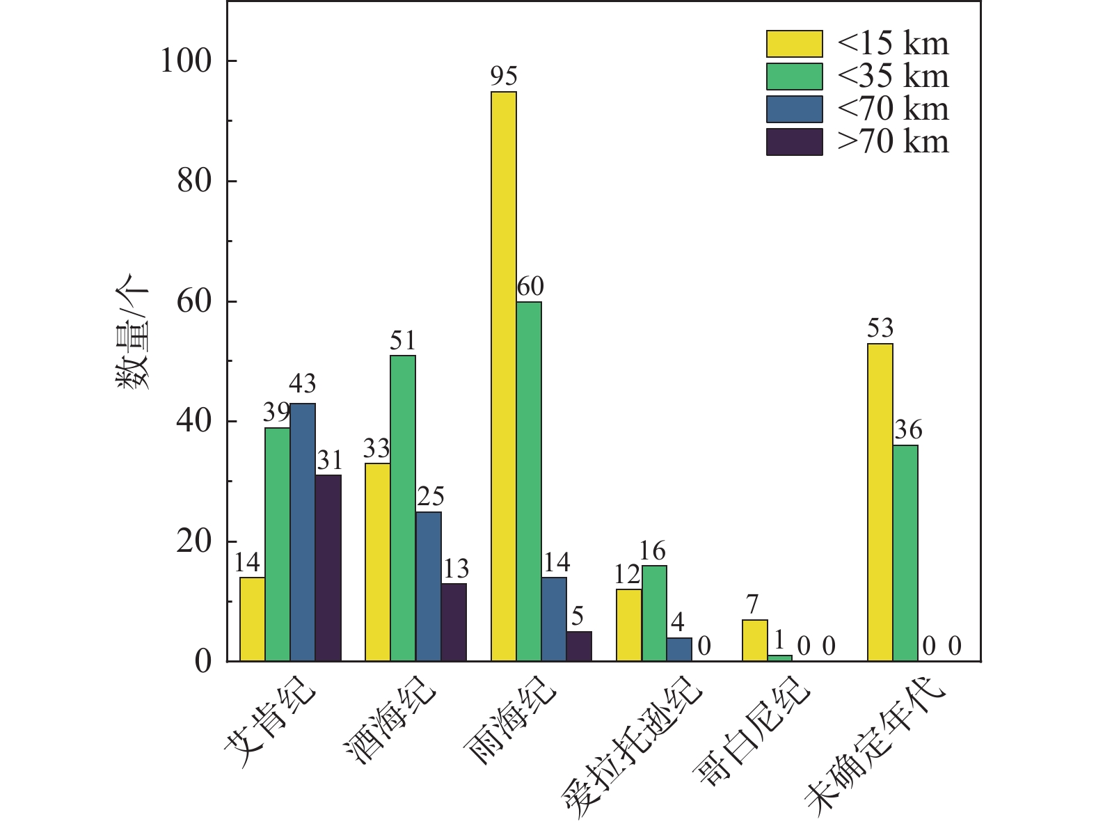
图 11 不同地质年代各直径范围不同撞击坑占比
Figure 11. The proportion of impact craters of different diameters in different geological ages

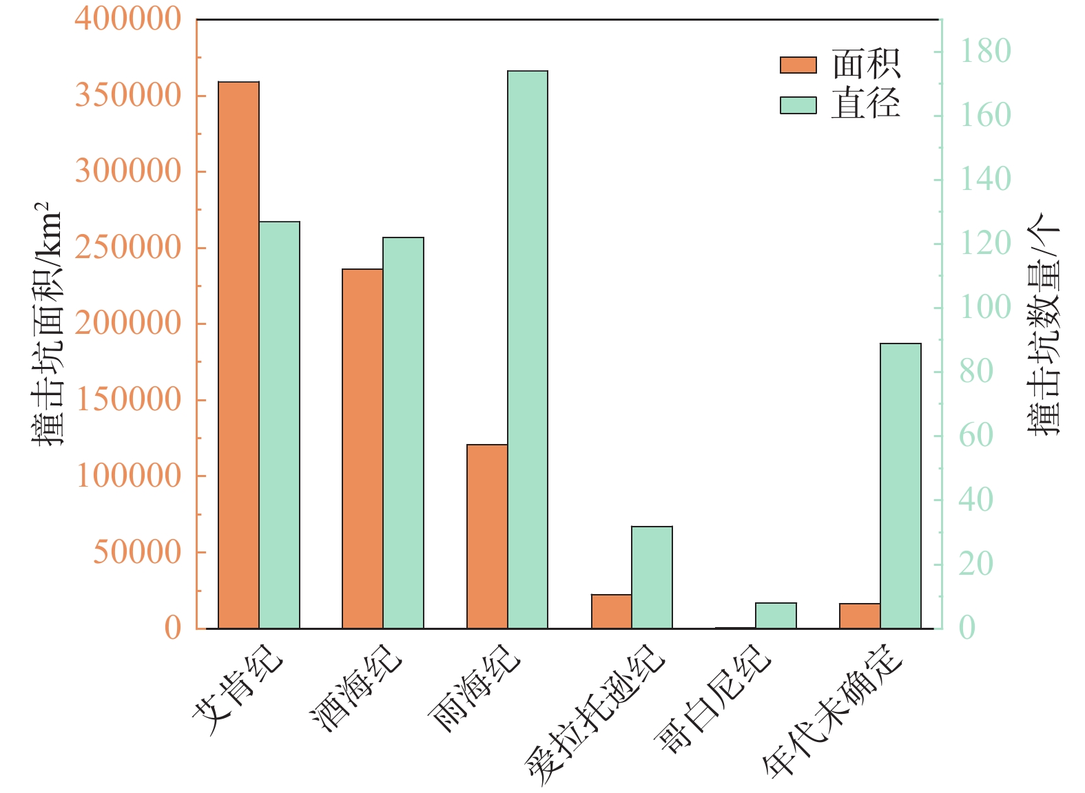
图 12 不同地质年代坑物质面积与数量占比
Figure 12. The proportion of crater material area and quantity in different geological ages
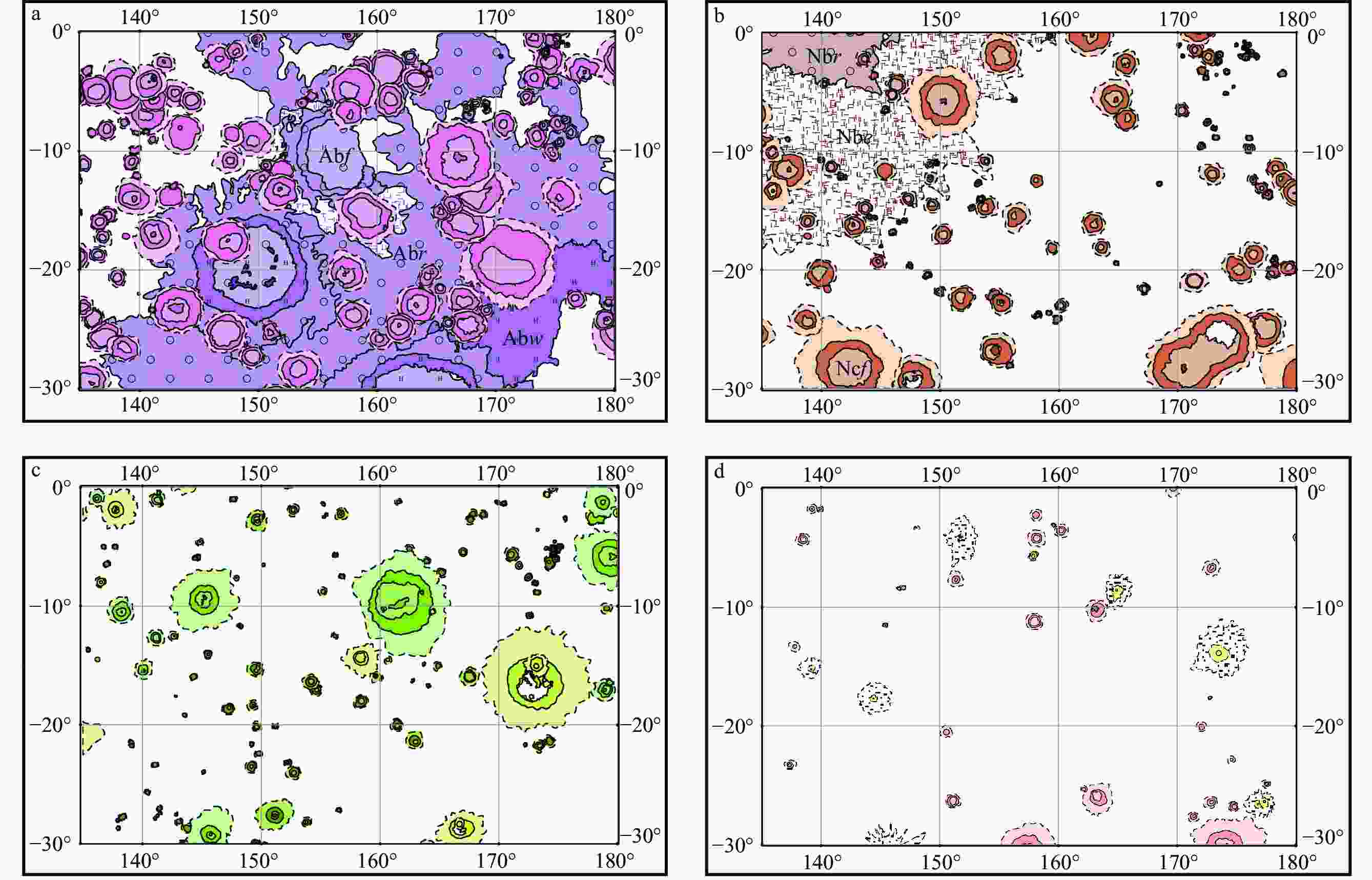
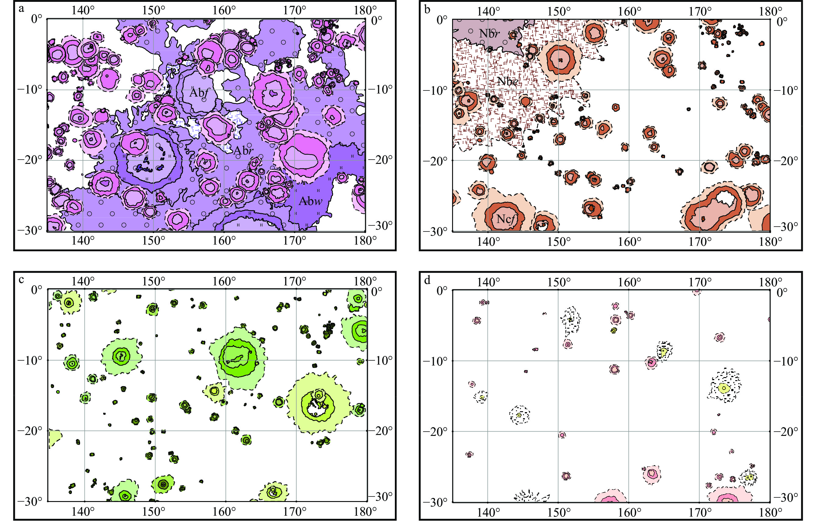
图 13 加加林地区各时期外动力地质作用
图例说明同图5a—艾肯纪撞击坑(盆地);b—酒海纪撞击坑(盆地);c—雨海纪撞击坑(盆地);d—爱拉托逊纪−哥白尼纪撞击坑
Figure 13. Impact craters (basins) formed in different periods by exodynamic geological processes in the Gagarin region
(a) Aitkenian Period; (b) Nectarian Period; (c) Imbrian Period; (d) Eratosthenian Period–Copernican PeriodRefer to Fig.5 for legend details.
表 1 研究区撞击坑直径和数量
Table 1. Craters' diameters and numbers in the study area
直径/km 不同地质年代撞击坑的数量/个 艾肯纪 酒海纪 雨海纪 爱拉托逊纪 哥白尼纪 年代未确定 总计 <15 14 33 95 12 7 53 214 <35 39 51 60 16 1 36 203 <70 43 25 14 4 0 0 86 >70且<200 31 13 5 0 0 0 49 总计 127 122 174 32 8 89 552  下载: 导出CSV
-
[1] AMBROSE W A, WILLIAMS D A, 2011. Recent advances and current research issues in lunar stratigraphy[M]. Boulder: Geological Society of America. [2] ANDREWS-HANNA J C, 2013. The origin of the non-mare mascon gravity anomalies in lunar basins[J]. Icarus, 222(1): 159-168. doi: 10.1016/j.icarus.2012.10.031 [3] CHEN J P, WANG X, WANG N, et al, 2014. The lunar geological mapping based on Chang'e data: Serenitatis-Tranquillitatis area as an example[J]. Earth Science Frontiers, 21(6): 7-18. (in Chinese with English abstract [4] Crater Analysis Techniques Working Group, 1979. Standard techniques for presentation and analysis of crater size-frequency data[J]. Icarus, 37(2): 467-474. doi: 10.1016/0019-1035(79)90009-5 [5] COMPSTON W, WILLIAMS I S, 1983. U-Pb Geochronology of zircons from Lunar Breccia 73217 using a Sensitive High Resolution Ion Microprobe. Proc. XIV Lunar Planetary Science Conference[J]. Journal of Geophysical Research Atmospheres, 89. [6] DING X Z, WANG L, HAN K Y, et al, 2014. The lunar digital geological mapping based on ArcGIS: Taking the Arctic region as an example[J]. Earth Science Frontiers, 21(6): 19-30. (in Chinese with English abstract [7] DOWTY E, KEIL K, PRINZ M, 1974. Lunar pyroxene-phyric basalts: crystallization under supercooled conditions[J]. Journal of Petrology, 15(3): 419-453. doi: 10.1093/petrology/15.3.419 [8] GOOSSENS S, SABAKA T J, WIECZOREK M A, et al, 2020. High-resolution gravity field models from GRAIL data and implications for models of the density structure of the Moon's crust[J]. Journal of Geophysical Research: Planets, 125(2): e2019JE006086. doi: 10.1029/2019JE006086 [9] GUO D J, LIU J Z, ZHANG L, et al, 2014. The methods of lunar geochronology study and the subdivisions of lunar geologic history[J]. Earth Science Frontiers, 21(6): 45-61. (in Chinese with English abstract [10] HAN K Y, PANG J F, DING X Z, et al, 2012. A study of digital lunar geological mapping (Sinus iridum Quadrangle) based on AreGIS[J]. Earth Science Frontiers, 19(6): 104-109. (in Chinese with English abstract [11] HARTMANN W K, NEUKUM G, 2001. Cratering chronology and the evolution of mars[J]. Space Science Reviews, 96(1-4): 165-194. [12] HARUYAMA J, OHTAKE M, MATSUNAGA T, et al, 2008. Planned radiometrically calibrated and geometrically corrected products of lunar high-resolution Terrain Camera on SELENE[J]. Advances in Space Research, 42(2): 310-316. doi: 10.1016/j.asr.2007.04.062 [13] HARUYAMA J, OHTAKE M, MATSUNAGA T, et al, 2009. Long-lived volcanism on the lunar farside revealed by SELENE Terrain Camera[J]. Science, 323(5916): 905-908. doi: 10.1126/science.1163382 [14] HIESINGER H, 2003. Ages and stratigraphy of mare basalts in Oceanus Procellarum, Mare Nubium, Mare Cognitum, and Mare Insularum[J]. Journal of Geophysical Research: Planets, 108(E7): 5065. [15] HIESINGER H, JAUMANN R, NEUKUM G, et al, 2000. Ages of mare basalts on the lunar nearside[J]. Journal of Geophysical Research: Planets, 105(E12): 29239-29275. doi: 10.1029/2000JE001244 [16] HIESINGER H, HEAD III J W, WOLF U, et al, 2010. Ages and stratigraphy of lunar mare basalts in Mare Frigoris and other nearside Maria based on crater size-frequency distribution measurements[J]. Journal of Geophysical Research: Planets, 115(E3): E03003. [17] JI J Z, GUO D J, LIU J Z, et al, 2022. The 1: 2, 500, 000-scale geologic map of the global Moon[J]. Science Bulletin, 67(15): 1544-1548. (in Chinese with English abstract doi: 10.1016/j.scib.2022.05.021 [18] JOLLIFF B L, GILLIS J J, HASKIN L A, et al, 2000. Major lunar crustal terranes: Surface expressions and crust-mantle origins[J]. Journal of Geophysical Research: Planets, 105(E2): 4197-4216. doi: 10.1029/1999JE001103 [19] KONOPLIV A S, PARK R S, YUAN D N, et al, 2013. The JPL lunar gravity field to spherical harmonic degree 660 from the GRAIL Primary Mission[J]. Journal of Geophysical Research: Planets, 118(7): 1415-1434. doi: 10.1002/jgre.20097 [20] LING Z C, ZHANG J, WU Z C, et al , 2013. The compositional distribution and rock types of the Aristarchus region on the moon[J]. Scientia Sinica: Physica, Mechanica & Astronomica, 43(11): 1403-1410. (in Chinese with English abstract [21] The lunar rock types as determined by Chang'E-1 IIM data: A case study of Mare Imbrium-Mare Frigoris region (LQ-4)[J]. Earth Science Frontiers, 21(6): 107-120. (in Chinese with English abstract [22] LIU J Z, GUO D J, JI J Z, et al, 2015. Lunar tectonic framework and its evolution inhomogeneity[J]. Journal of Deep Space Exploration, 2(1): 75-79. (in Chinese with English abstract [23] LU T Q, 2017. Research on distribution characteristics of lunar fault and wrinkle ridge[D]. Changchun: Jilin University. (in Chinese with English abstract [24] LU T Q, CHEN S B, ZHU K, 2019. Global identification and spatial distribution of lunar subsurface faults from GRAIL gravity data. Chinese Journal of Geophysics, 62(8): 2835-2844. (in Chinese with English abstract [25] LU T Q, 2020. Study on remote sensing recognition and evolution of lunar tectonics[D]. Changchun: Jilin University. (in Chinese with English abstract [26] LUCEY P G, BLEWETT D T, JOLLIFF B L, 2000a. Lunar iron and titanium abundance algorithms based on final processing of Clementine ultraviolet-Visible images[J]. Journal of Geophysical Research: Planets, 105(E8): 20297-20305. doi: 10.1029/1999JE001117 [27] LUCEY P G, BLEWETT D T, TAYLOR G J, et al, 2000b. Imaging of lunar surface maturity[J]. Journal of Geophysical Research: Planets, 105(E8): 20377-20386. doi: 10.1029/1999JE001110 [28] LUO L, LIU J Z, ZHANG L, et al, 2017. Research on the classification system of lunar lineaments[J]. Acta Petrologica Sinica, 33(10): 3285-3301. (in Chinese with English abstract [29] NEUKUM G, IVANOV B A, HARTMANN W K, 2001. Cratering records in the inner solar system in relation to the lunar reference system[C]//Chronology and evolution of mars. Bern: Springer: 55-86. [30] OHTAKE M, MATSUNAGA T, HARUYAMA J, et al, 2009. The global distribution of pure anorthosite on the Moon[J]. Nature, 461(7261): 236-240. doi: 10.1038/nature08317 [31] OUYANG Z Y, 2005. Introduction to lunar science[M]. Beijing: China Astronautic Publishing House: 1-362. (in Chinese) [32] OUYANG Z Y, LIU J Z, 2014. The origin and evolution of the Moon and its geological mapping[J]. Earth Science Frontiers, 21(6): 1-6. (in Chinese with English abstract [33] PALME H, SPETTEL B, JOCHUM K P, et al,1991. Lunar highland meteorites and the composition of the lunar crust[J]. Geochimica Et Cosmochimica Acta,55:3105-3122 [34] PASCKERT J H, HIESINGER H, VAN DER BOGERT C H, 2018. Lunar farside volcanism in and around the South Pole–Aitken basin[J]. Icarus, 299: 538-562. doi: 10.1016/j.icarus.2017.07.023 [35] ROBINSON M S, BRYLOW S M, TSCHIMMEL M, et al, 2010. Lunar reconnaissance orbiter camera (LROC) instrument overview[J]. Space Science Reviews, 150(1-4): 81-124. doi: 10.1007/s11214-010-9634-2 [36] STÖFFLER D, RYDER G, IVANOV B A, et al, 2006. Cratering history and lunar chronology[J]. Reviews in Mineralogy and Geochemistry, 60(1): 519-596. doi: 10.2138/rmg.2006.60.05 [37] TIAN F F, CHEN S B, CAO Y J, et al, 2018. Analysis of Rain Sea Terrain and Impact Crater Characteristics Based on Roughness[J]. World Geology, 37(01): 302-308. (in Chinese with English abstract [38] WANG J, CHENG W M, ZHOU C H, 2015. A global inventory of lunar craters: identification, classification, and distribution[J]. Progress in Geography, 34(3): 330-339. (in Chinese with English abstract [39] WANG L, 2015. The study on the compilation of digital geological map in the north region of the moon[D]. Beijing: China University of Geosciences (Beijing). (in Chinese with English abstract [40] WANG L, DING X Z, HAN K Y, et al, 2015a. The compilation of the lunar digital geological map and a discussion on the tectonic evolution of the moon[J]. Geology in China, 42(1): 331-341. (in Chinese with English abstract [41] WANG L, DING X Z, HAN T L, et al, 2015b. The digital geological mapping and geological and geomorphic features of Tycho Crater of the Moon[J]. Earth Science Frontiers, 22(2): 251-262. (in Chinese with English abstract [42] WANG Q L, LIU J Z, GUO D J, et al, 2018. Determination of multi-ring structure and analysis on the deep structure of the Lunar Mare Imbrium Basin[J]. Earth Science Frontiers, 25(1): 297-313. (in Chinese with English abstract [43] WARREN P H, 1985. The magma ocean concept and Lunar evolution[J]. Annual Review of Earth and Planetary Sciences, 13: 201-240. doi: 10.1146/annurev.ea.13.050185.001221 [44] Wilhelms D. E. , MCCAULEY J F, TRASK N J, 1987. The geologic history of the moon[R]. Washington: USGS Numbered Series. [45] Wieczorek M. A. , Jolliff B. L. andKhan A. 2006. The Constitution and Structure of the Lunar Interior[J]. Reviews in Mineralogy & Geochemistry, 60(1): 221-364. [46] Wieczorek M A, NEUMANN G A, Nimmo F, et al,2013. The Crust of the Moon as Seen by GRAIL[J]. Science,339:671-675 [47] XU K J, WANG L, HAN K Y, et al, 2020. Design and implementation of symbol library of lunar geological map at 1: 2.5 M[J]. Earth Science, 45(7): 2650-2661. (in Chinese with English abstract [48] XU X Q, HUI H J, CHEN W, et al, 2020. Formation of lunar highlands anorthosites[J]. Earth and Planetary Science Letters, 536: 116138. doi: 10.1016/j.jpgl.2020.116138 [49] YAO M J, CHEN J P, WANG X, et al, 2016. The grading and evolution analysis of lunar crater based on optimum partition and grading method[J]. Acta Petrologica Sinica, 32(1): 119-126. (in Chinese with English abstract [50] YUE Z Y, DI K C, LIU J Z, 2021. Principle and application of planetary surface dating method based on crater size-frequency distribution measurements[J]. Bulletin of Mineralogy, Petrology and Geochemistry, 40(5): 1130-1142. (in Chinese with English abstract [51] 陈建平,王翔,王楠,等,2014. 基于嫦娥数据澄海—静海幅地质图编研[J]. 地学前缘,21(6):7-18. [52] 丁孝忠,王梁,韩坤英,等,2014. 基于ArcGIS的月球数字地质填图:以月球北极地区为例[J]. 地学前缘,21(6):19-30. [53] 郭弟均,刘建忠,张莉,等,2014. 月球地质年代学研究方法及月面历史划分[J]. 地学前缘,21(6):45-61. [54] 韩坤英,庞健峰,丁孝忠,等,2012. 基于ArcGIS的月球虹湾地区数字地质图编制研究[J]. 地学前缘,19(6):104-109. [55] 籍进柱,郭弟均,刘建忠,等,2022. 1:250万月球全月地质图(英文)[J]. 科学通报,67(15):1544-1548. [56] 凌宗成,张江,武中臣,等,2013. 月球Aristarchus地区的物质成分与岩石类型分布[J]. 中国科学:物理学 力学 天文学,43(11):1403-1410. [57] 凌宗成,刘建忠,张江,等,2014. 基于“嫦娥一号”干涉成像光谱仪数据的月球岩石类型填图:以月球雨海—冷海地区(LQ-4)为例[J]. 地学前缘,21(6):107-120. [58] 刘建忠,郭弟均,籍进柱,等,2015. 月球的构造格架及其演化差异[J]. 深空探测学报,2(1):75-79. [59] 陆天启,2017. 月球断裂和皱脊构造分布特征研究[D]. 长春:吉林大学. [60] 陆天启,陈圣波,朱凯,2019. 基于GRAIL重力数据的月球深部断裂识别和空间分布研究[J]. 地球物理学报,62(8):2835-2844. [61] 陆天启,2020. 月球构造遥感识别及其演化研究[D]. 长春:吉林大学. [62] 罗林,刘建忠,张莉,等,2017. 月球线性构造分类体系研究[J]. 岩石学报,33(10):3285-3301. [63] 欧阳自远,2005. 月球科学概论[M]. 北京:中国宇航出版社:1-362 [64] 欧阳自远,刘建忠,2014. 月球形成演化与月球地质图编研[J]. 地学前缘,21(6):1-6. [65] 田粉粉,陈圣波,曹一晶,等,2018. 基于粗糙度的雨海地形及撞击坑特征分析[J]. 世界地质,37(01):302-308. [66] 王娇,程维明,周成虎,2015. 全月球撞击坑识别、分类及空间分布[J]. 地理科学进展,34(3):330-339. [67] 王梁,丁孝忠,韩坤英,等,2015a. 月球数字地质图的编制与研究[J]. 中国地质,42(1):331-341. [68] 王梁,丁孝忠,韩同林,等,2015b. 月球第谷撞击坑区域数字地质填图及地质地貌特征[J]. 地学前缘,22(2):251-262. [69] 王庆龙,刘建忠,郭弟均,等,2018. 月球雨海盆地多环结构的厘定及其深部构造研究[J]. 地学前缘,25(1):297-313. [70] 许可娟,王梁,韩坤英,等,2020. 1:250万月球地质图符号库的设计与实现[J]. 地球科学,45(7):2650-2661. [71] 姚美娟,陈建平,王翔,等,2016. 基于最优分割分级法的月球撞击坑分级及其演化分析[J]. 岩石学报,32(1):119-126. [72] 岳宗玉,邸凯昌,刘建忠,2021. 行星表面撞击坑统计定年原理及应用[J]. 矿物岩石地球化学通报,40(5):1130-1142. -

 下载:
下载:


计量
- 文章访问数: 3580
- HTML全文浏览量: 889
- PDF下载量: 104
- 被引次数: 0
