

Determination of the double-layer structure in orogenic belts and its geological significance
-
摘要: 当前,增生型造山带和碰撞型造山带的研究均取得了丰富的成果和创新性认识。二者过渡期间常常发生陆壳俯冲。然而,该俯冲具有什么样的构造变形特点,并如何影响造山带演化过程,长期未受到足够的关注。基于此,文中选择曾发生了陆壳俯冲的两个新生代时期的造山带(中国台湾造山带和雅鲁藏布江造山带)和一个中生代时期的造山带(羌塘造山带)开展研究,以期阐明陆壳俯冲的独特构造变形特征以及和造山过程的交互作用。研究发现,陆壳俯冲常常在造山带形成双层结构,上部为一套由史密斯地层组成的逆冲叠瓦扇构造体系,下部为一套具“岩块–基质”结构特征的俯冲杂岩。双层结构的上下部分物质组成相似,均以斜坡相–海底扇相沉积为主,也有陆棚相沉积。因此,由于构造变形时间相近,双层结构应是由同一套被动陆缘物质俯冲形成的深浅不同的构造体系。研究认为,在陆壳俯冲过程中,早期的斜坡–海底扇俯冲是形成双层结构的主要因素。后续的陆棚俯冲则对碰撞作用的发生起到了主导作用,从而使应变逐渐向克拉通内部扩展,形成前陆褶皱–冲断带。随着碰撞作用的持续,双层结构常常遭到构造破坏,深部的俯冲杂岩因此得以剥露至浅表。因此,文章的研究强调了陆壳俯冲和深俯冲物质的折返在造山带演化中的重要意义。Abstract: At present, the study of accretionary orogenic belts and collisional orogenic belts has achieved numerous insights and improvements. However, continental subduction, which often occurs during the oceanic and continental transition, has not received enough attention for a long time, such as what kind of structural deformation characteristics it has and how it affects the evolution of the orogenic belt. This paper studied two Cenozoic orogenic belts (the Taiwan orogenic belt and the Yarlung Zangbo River orogenic belt) and one Mesozoic orogenic belt (the Qiangtang orogenic belt) in order to clarify the unique structural deformation characteristics of continental subduction and its interaction with orogenic processes. It is found that the subduction of continental crust often forms a double-layer structure in the orogenic belt. The upper part is a set of thrust imbricate composed of Smith strata, and the lower part is a set of subduction complexes with a “blocks in the matrix” structure. The upper and lower parts of the double-layer structure are similar, mainly slope facies–submarine fan facies rocks and little shelf facies rocks. Due to the similar deformation time, the double-layer structure should be a structural system formed in different depths by the subduction of the same passive continental margin. We suppose that the subduction of the slope–submarine fan is the main factor for the formation of the double-layer structure. The subsequent continental shelf subduction could induce the collision and thus lead to strain’s gradual propagation to the craton’s interior, resulting in the foreland fold-thrust. Also, the double-layer structure is often destroyed during the collision, so the deeply underplated continental subduction complex can be exhumed to the shallow level. Therefore, this study also emphasizes the importance of continental subduction and the exhumation of subducted crustal rocks in the evolution of orogenic belts.
-

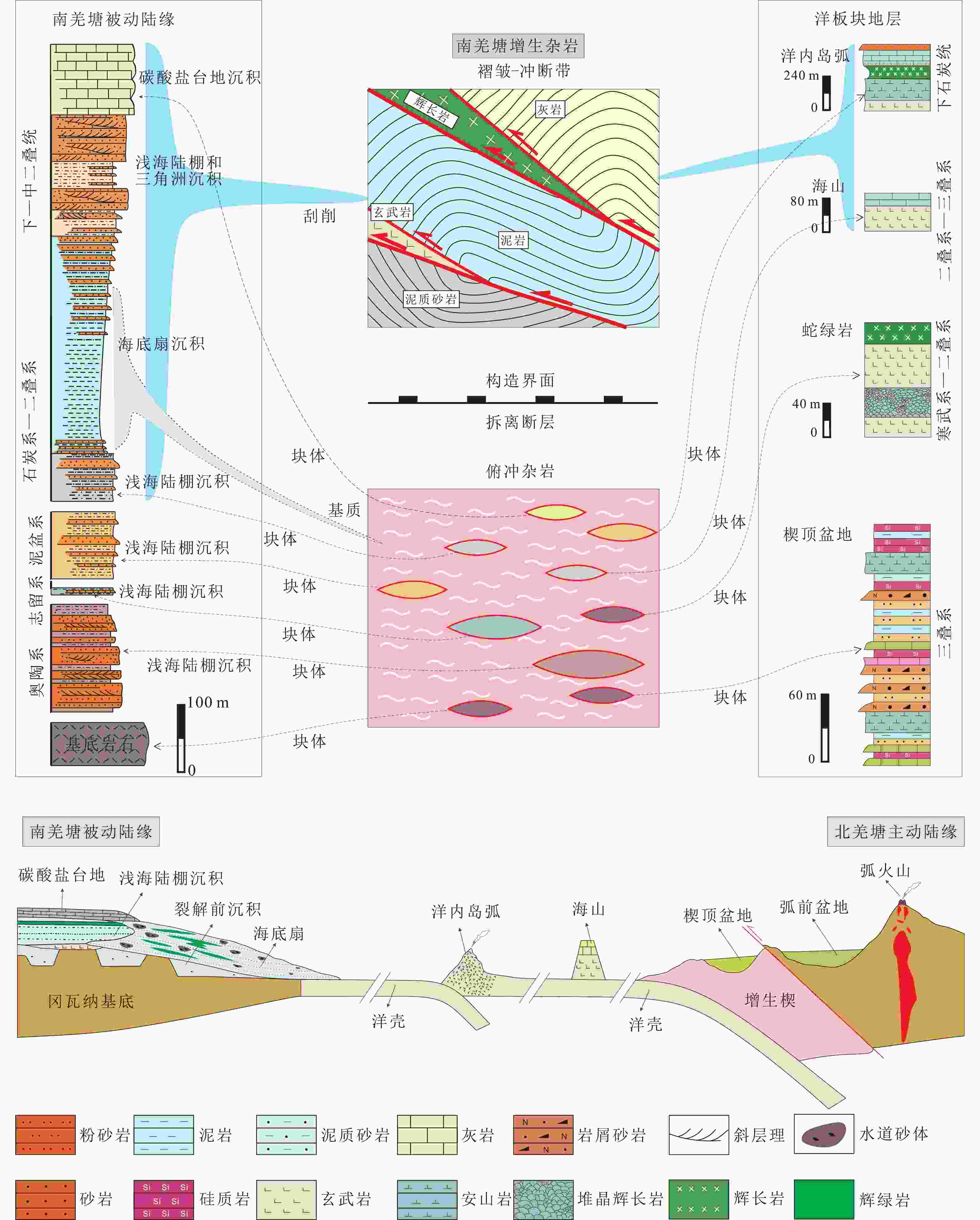
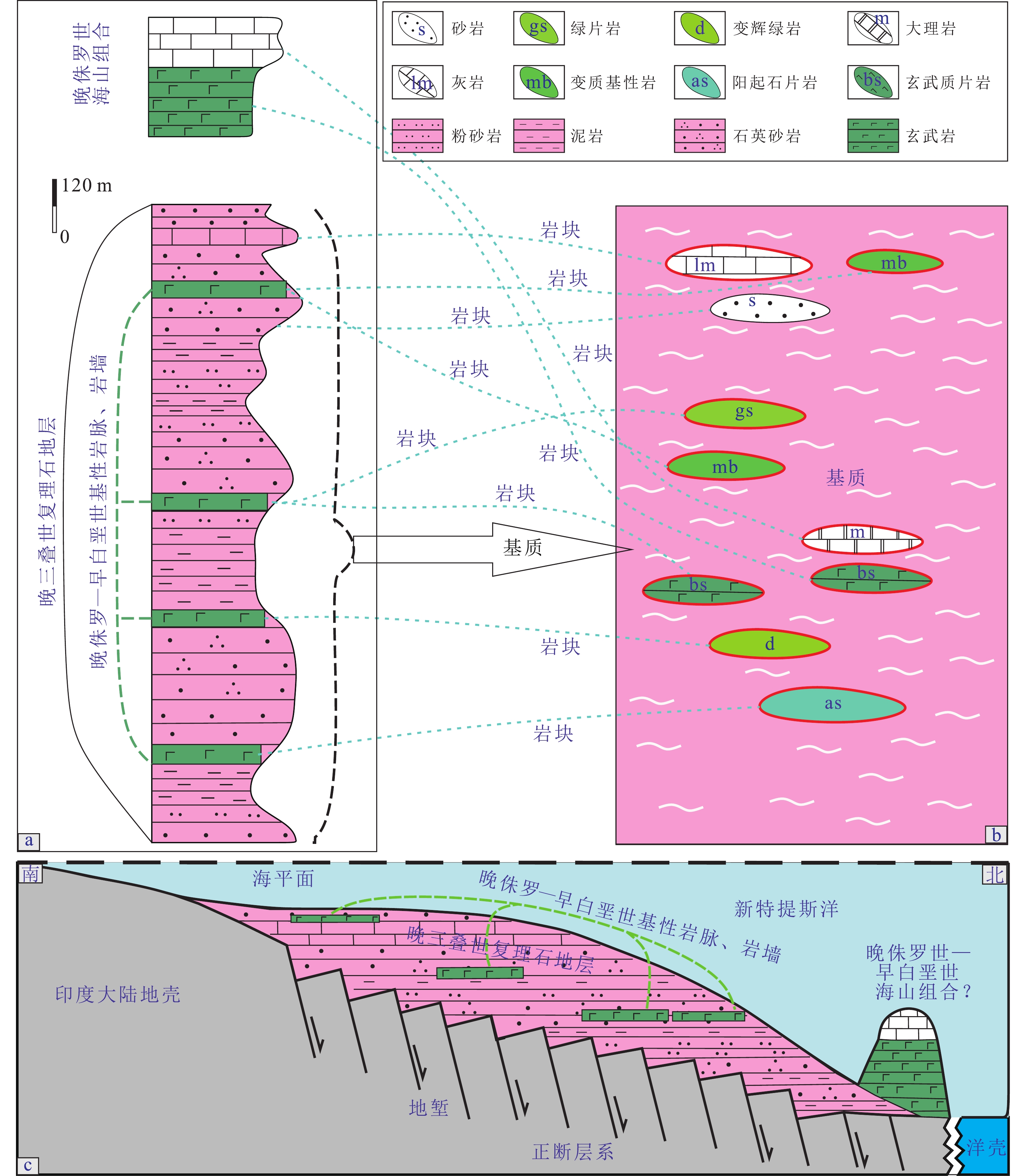
图 2 羌塘造山带物质组成示意图
Figure 2. Schematic diagram of the composition of the Qiangtang accretionary orogenic belt

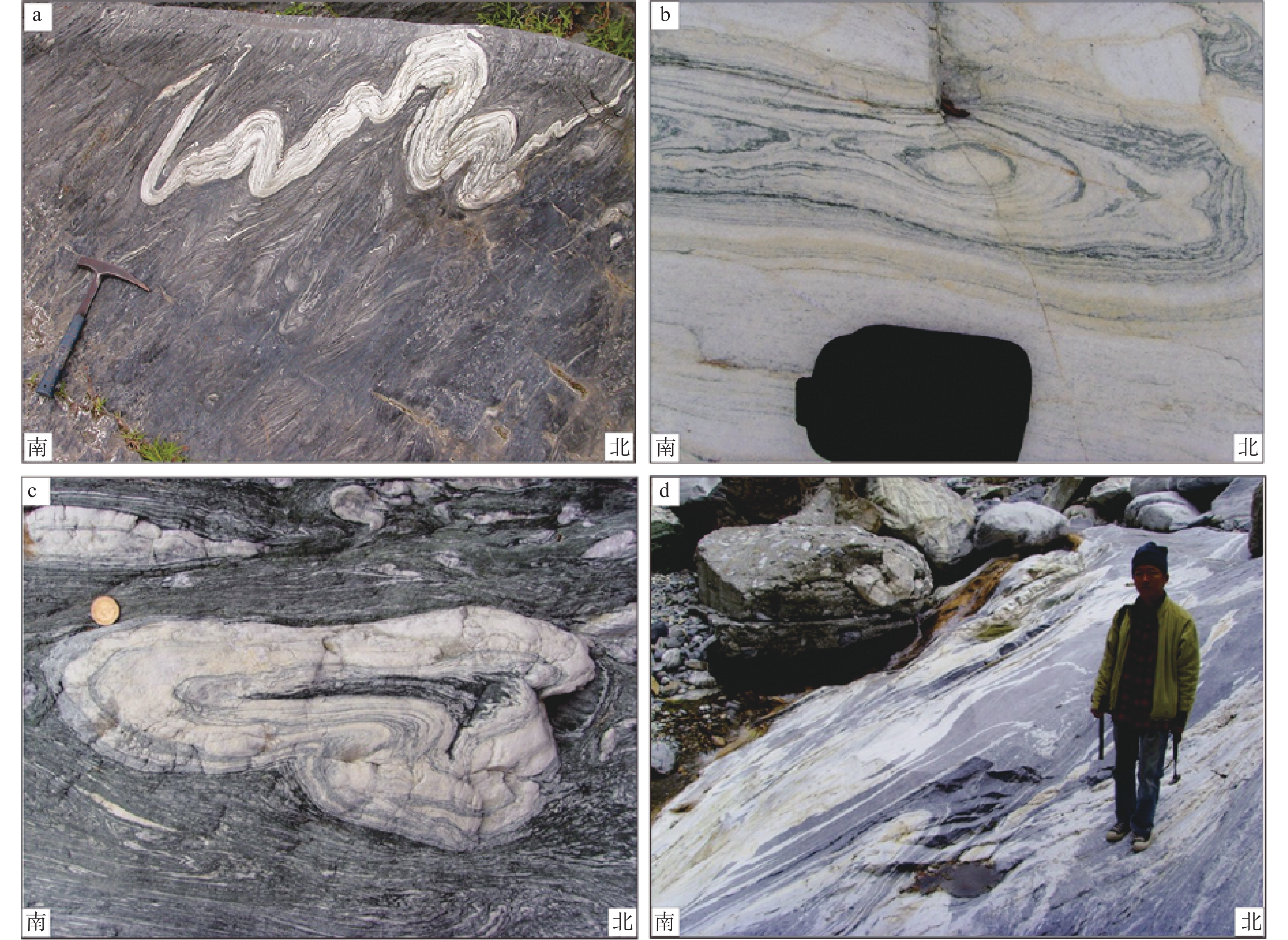
图 3 羌塘造山带双层构造体系示意图
Figure 3. Schematic diagram of the double-layer structure in the Qiangtang accretionary complex
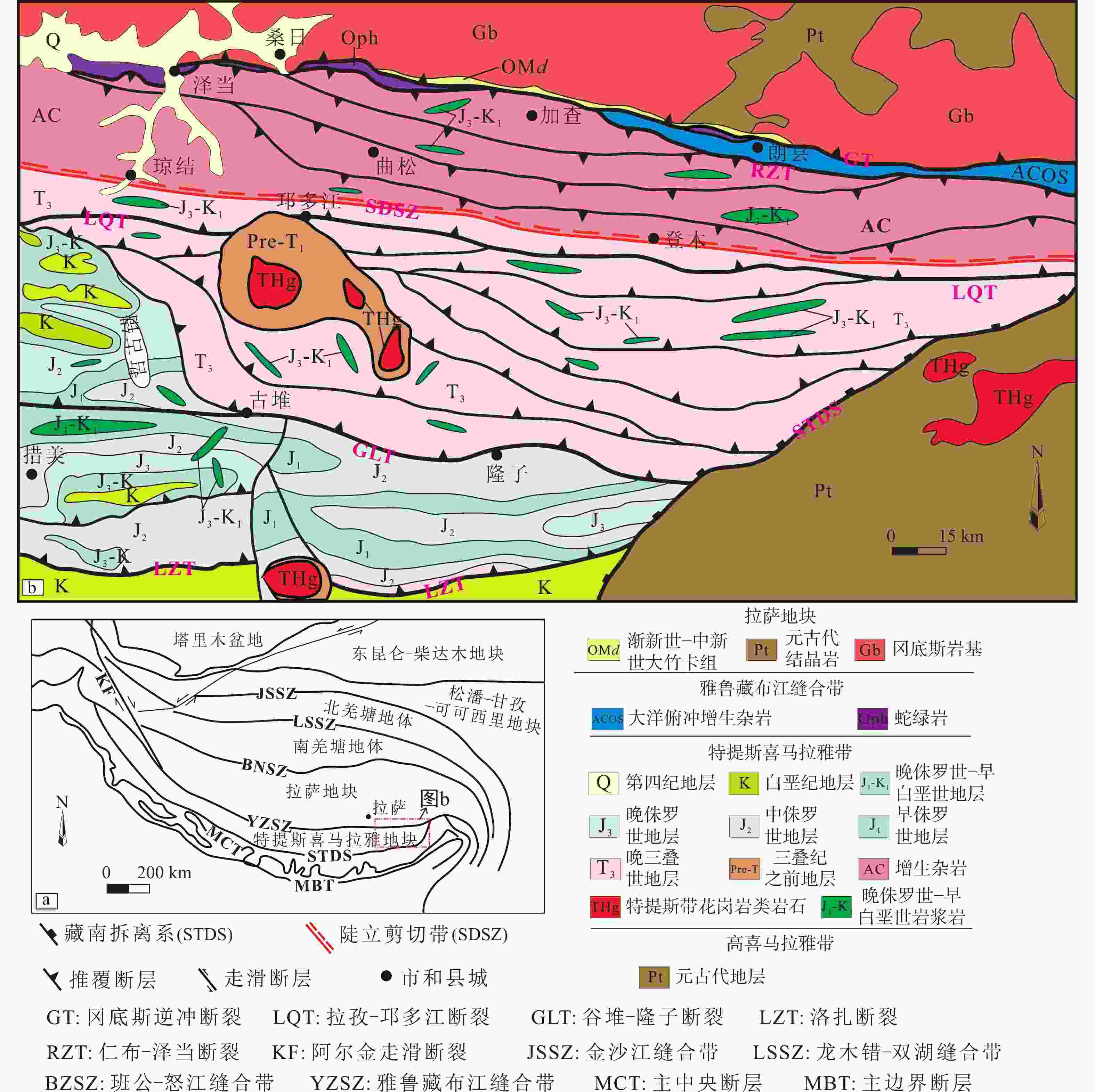
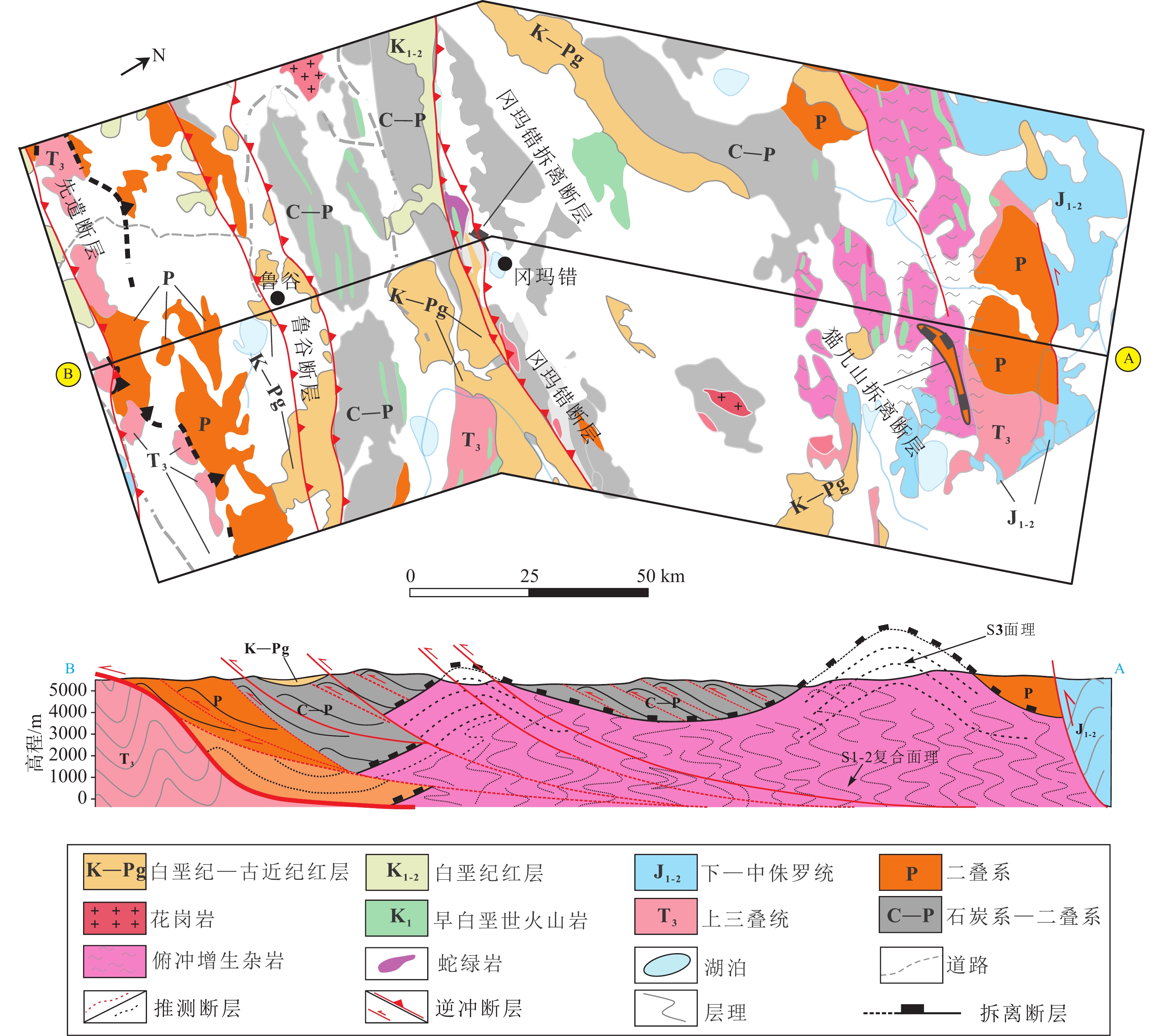
图 4 雅鲁藏布江造山带地质简图
Figure 4. Simplified geological map of the Yarlung Zangbo River orogenic belt
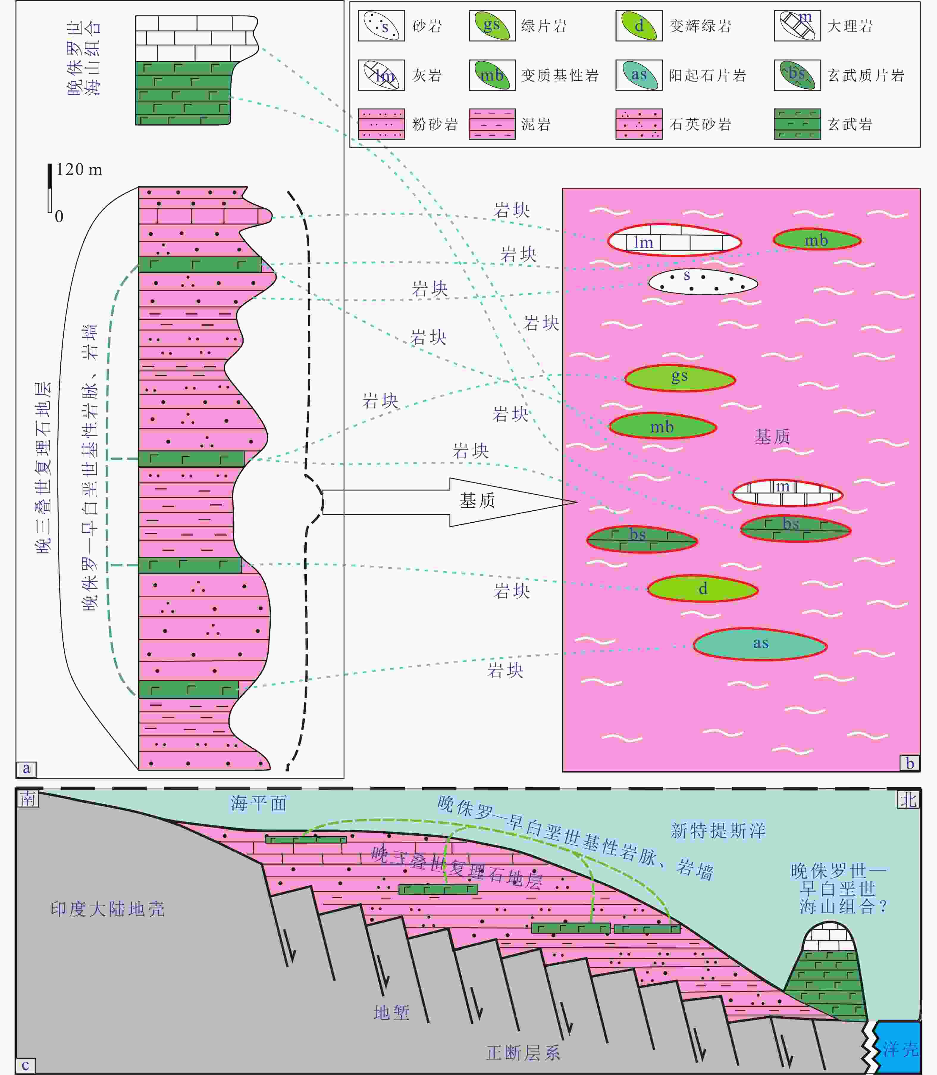
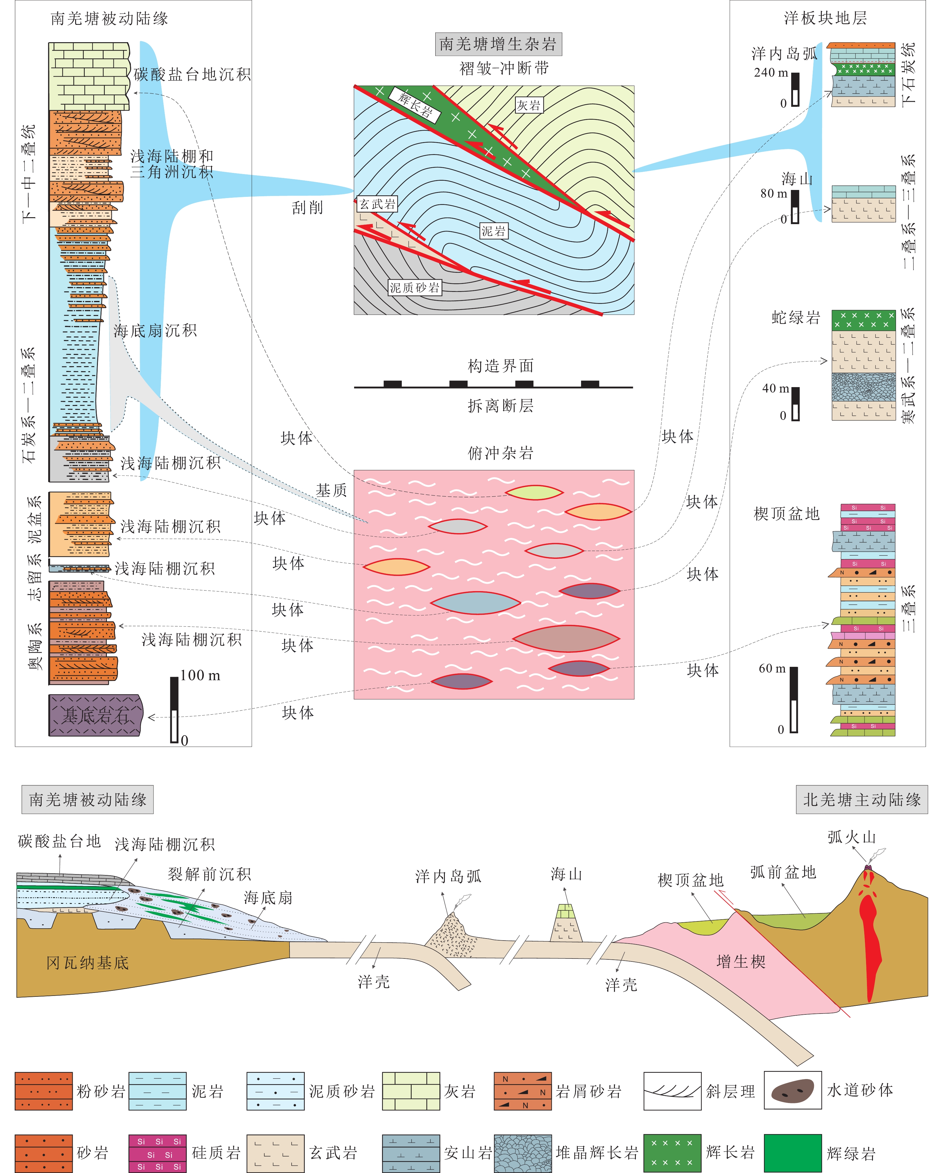
图 5 加查增生杂岩物质组成示意图
Figure 5. Schematic diagram of the composition of the Jiacha accretionary complex
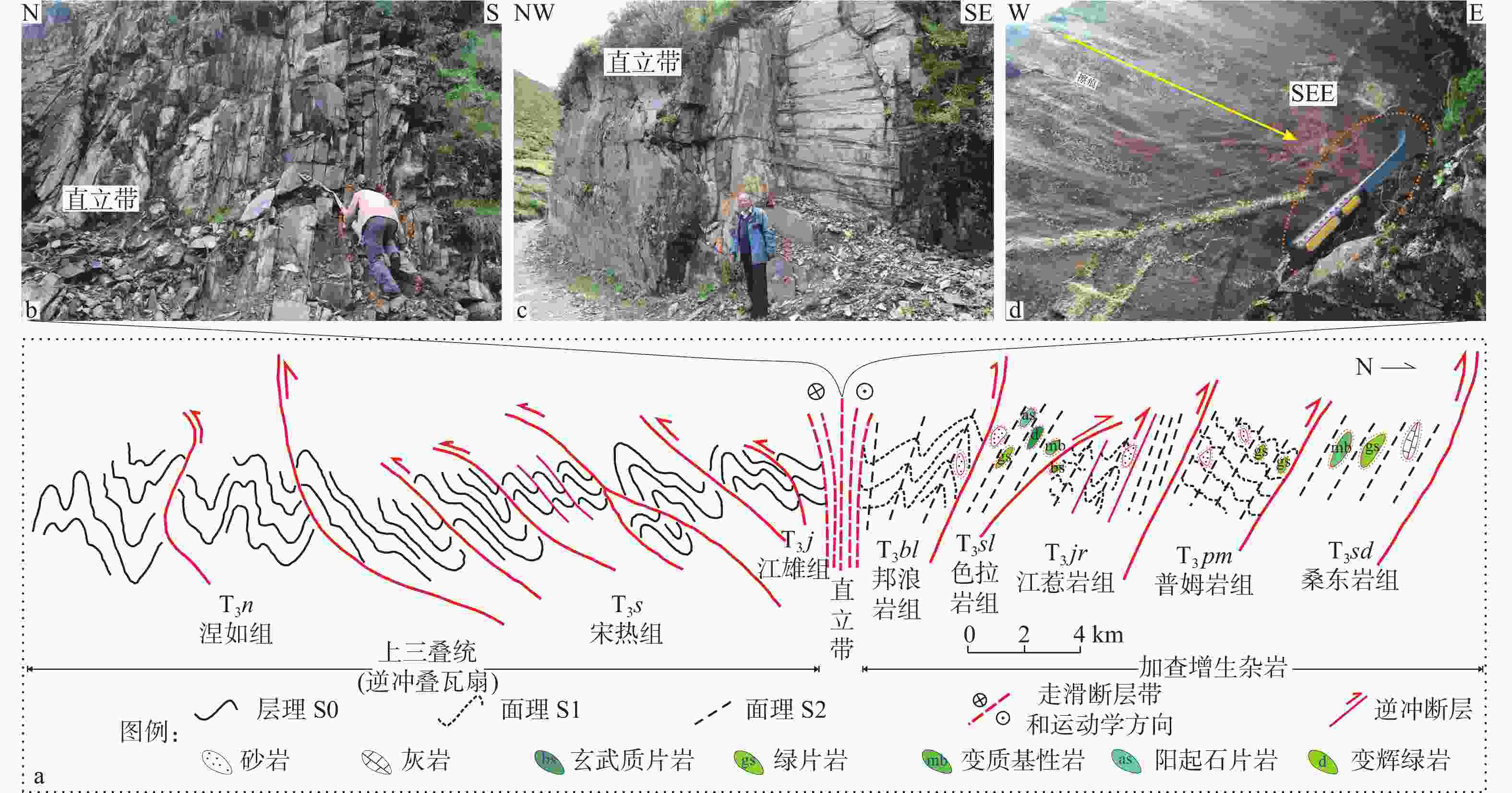
图 6 雅鲁藏布江造山带双层构造体系示意图及中央直立带
Figure 6. Schematic diagram of the double-layer structure in the Yarlung Zangbo River orogenic belt and the central steep belt
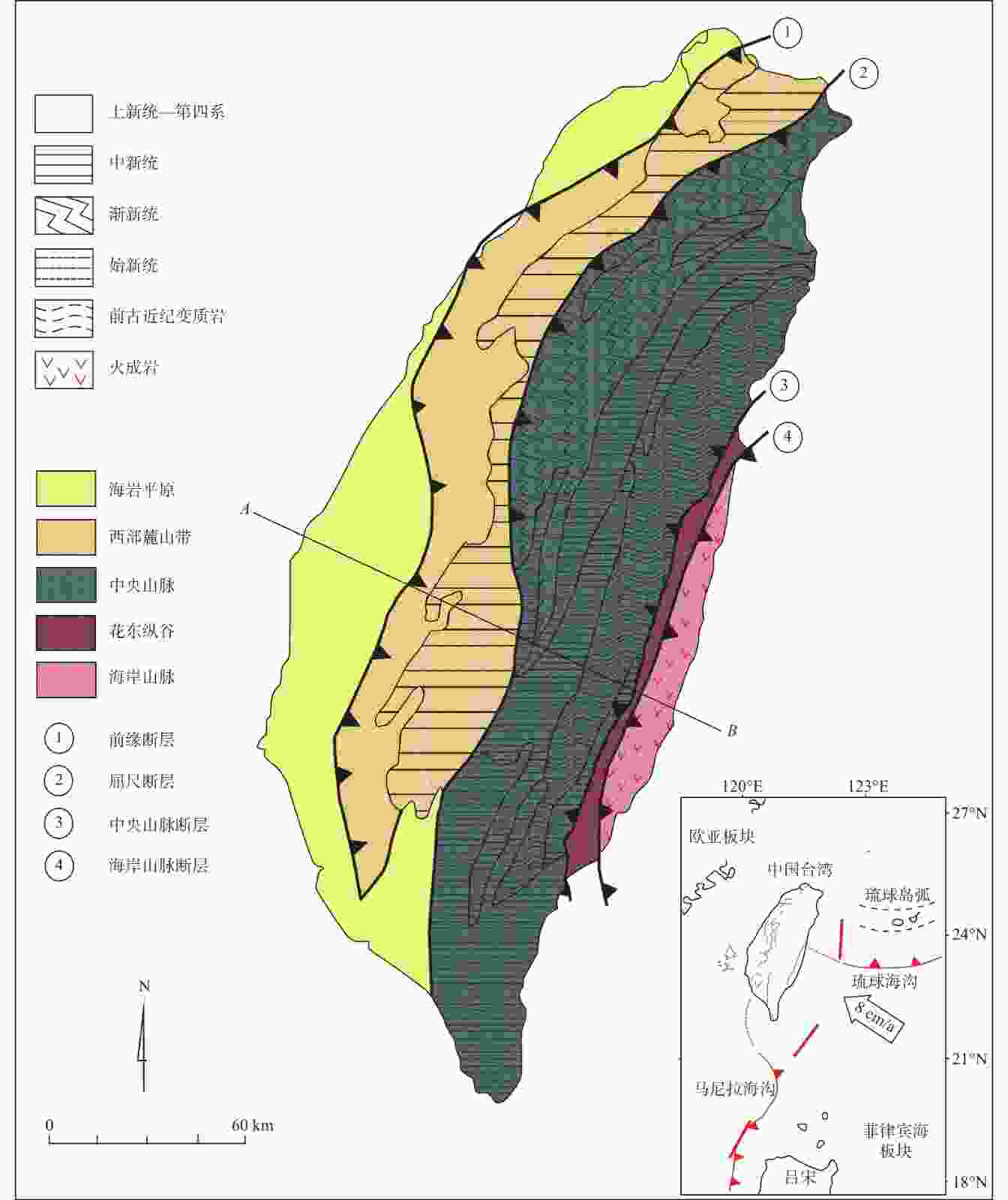
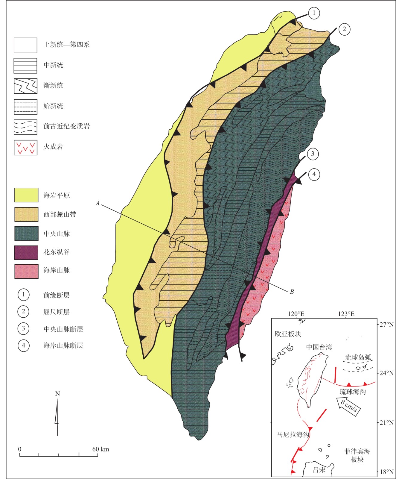
图 7 中国台湾造山带地质简图(据Huang et al.,2000修改)
Figure 7. Simplified geological map of the Taiwan orogenic belt in China (modified from Huang et al., 2000)
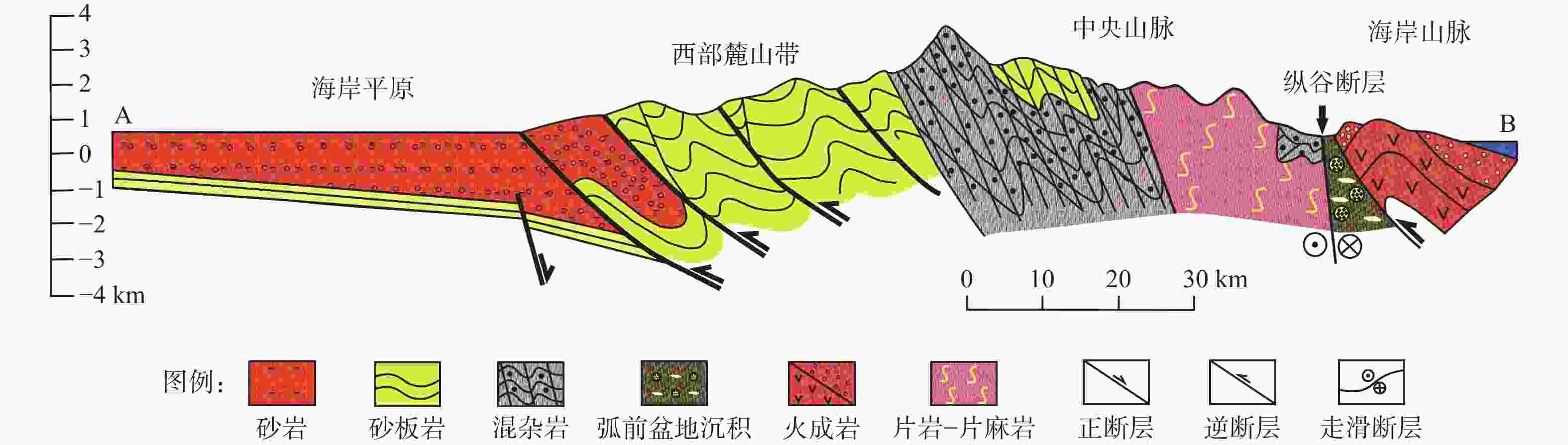
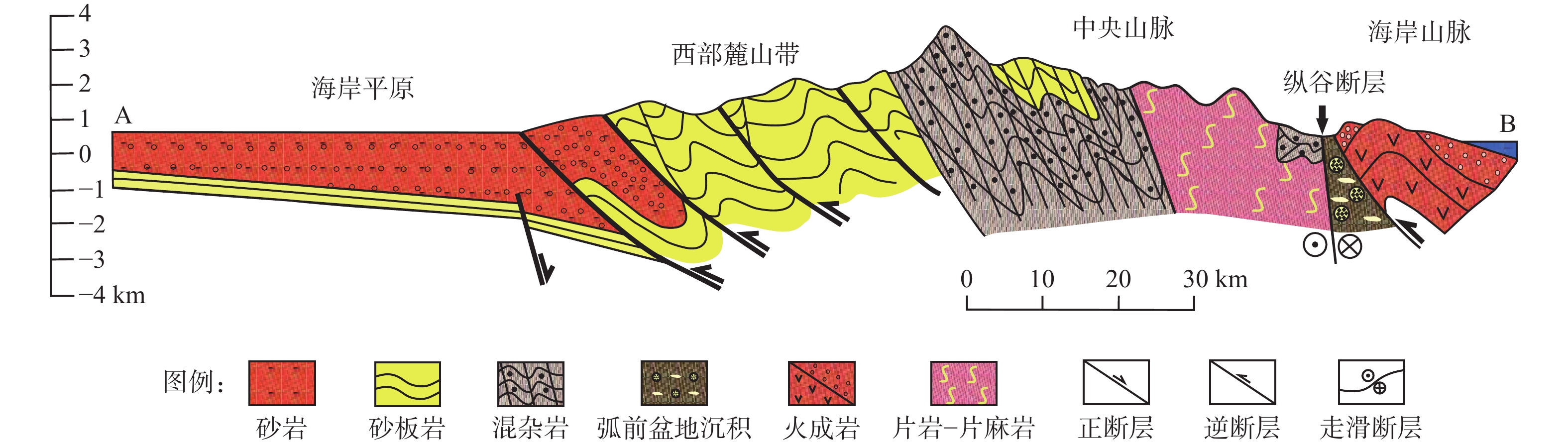
图 8 中国台湾造山带地质剖面简图(剖面AB位置见图7;据Huang et al.,2000修改)
Figure 8. Simplified geological profile of the Taiwan orogenic belt in China (modified from Huang et al., 2000)
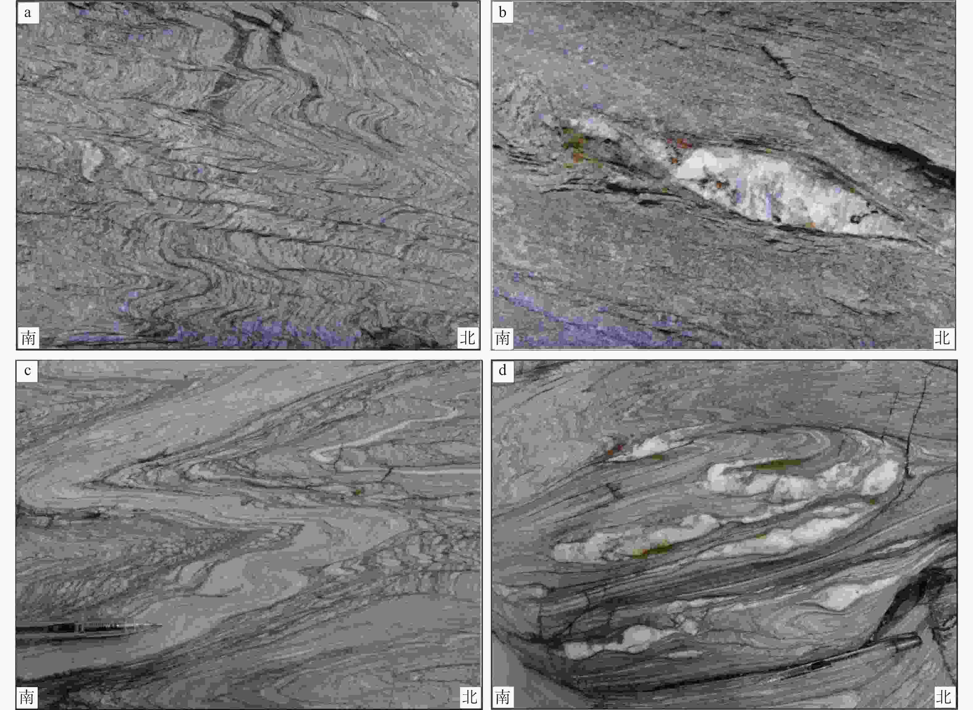
图 9 中央山脉变质岩系片岩变形特征
a—褶劈理S2;b—石英透镜体,具有右行剪切变形;c—构造片理被置换;d—长英质脉体揉流褶皱
Figure 9. Deformation characteristics of the schists in the Central Range complex
(a) Crenulation S2; (b) Quartz vein lens with dextral shear sense; (c) Schistose foliation was imposed; (d) Flow folds of felsic veins
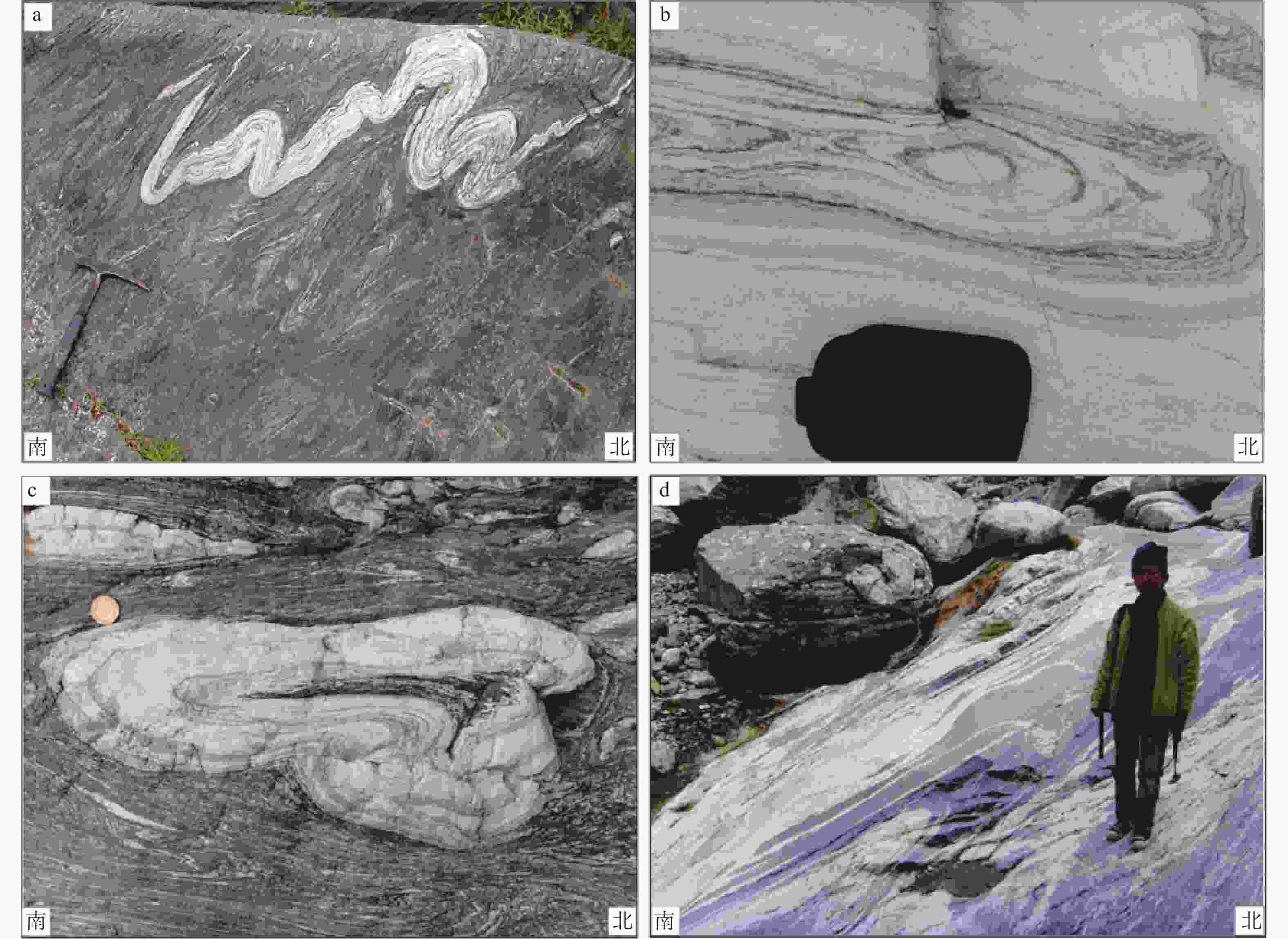
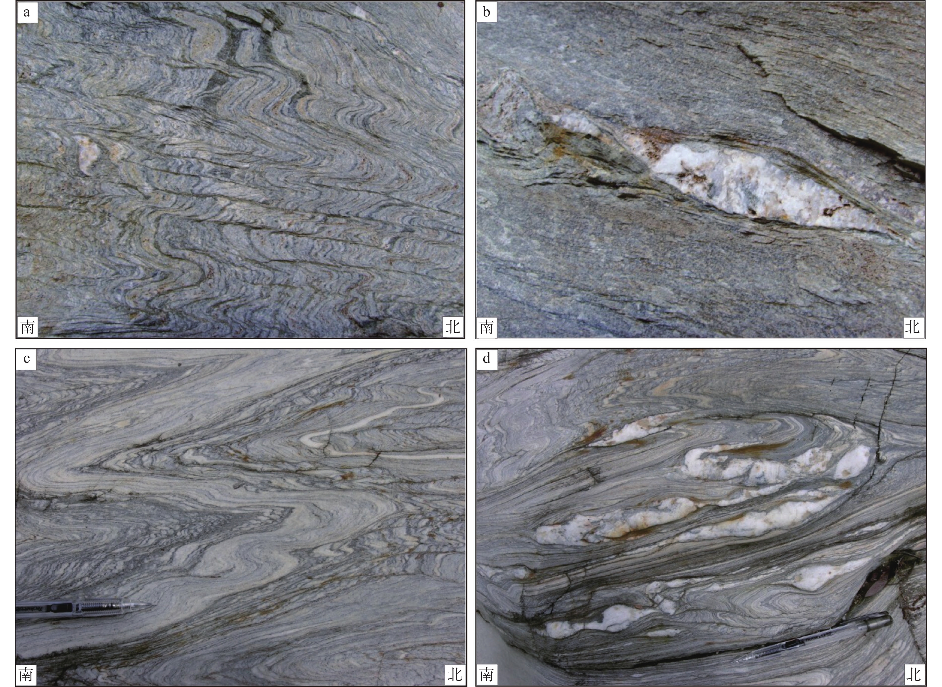
图 10 中国台湾中央山脉变质岩系中大理岩变形特征
a—XY面不对称褶皱;b、c—YZ面鞘褶皱;d—大理岩转折端流变加厚
Figure 10. Sheath folds of the marbles in the Central Range complex of Taiwan, China
(a) Asymmetric fold on the XY profile; (b) and (c) Sheath fold on the YZ profile; (d) The hinge zone of the sheath fold was thickened
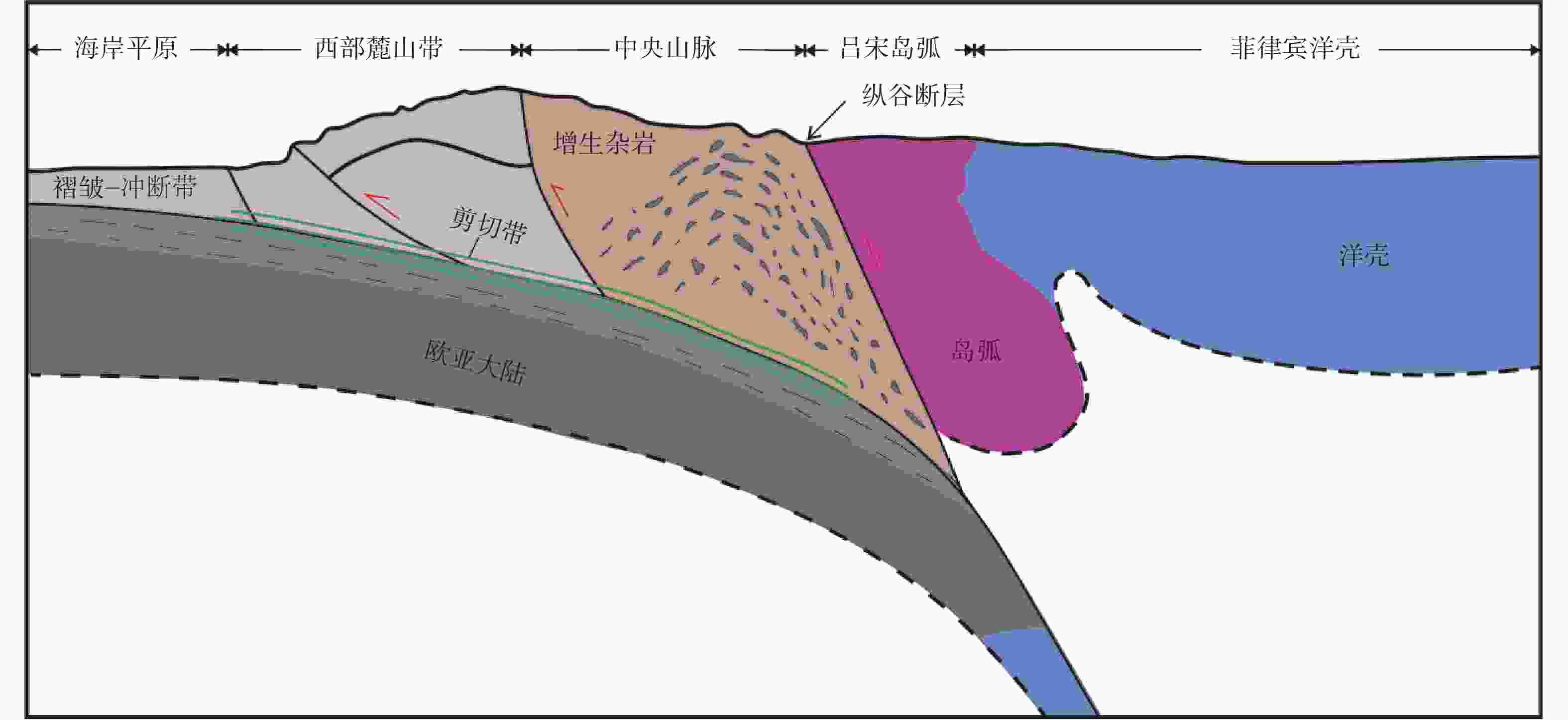
图 11 中国台湾造山带深部结构示意图(据Huang et al. ,2015;Chen et al. ,2019修改)
Figure 11. Schematic diagram of the deep structure of the orogenic belt in Taiwan, China (modified from Huang et al., 2015; Chen, 2019)
-
AIKMAN A B, HARRISON TM, LIN D, 2008. Evidence for early (> 44 Ma) Himalayan crustal thickening, Tethyan Himalaya, southeastern Tibet[J]. Earth and Planetary Science Letters, 274(1-2): 14-23. doi: 10.1016/j.jpgl.2008.06.038 BEYSSAC O, SIMOES M, AVOUAC J P, et al. , 2007. Late Cenozoic metamorphic evolution and exhumation of Taiwan[J]. Tectonics, 26(6): TC6001. BEYSSAC O, NEGRO F, SIMOES M, et al. , 2008. High‐pressure metamorphism in Taiwan: from oceanic subduction to arc‐continent collision?[J]. Terra Nova, 20(2): 118-125. doi: 10.1111/j.1365-3121.2008.00796.x CHAI B H T, 1972. Structure and tectonic evolution of Taiwan[J]. American Journal of Science, 272(5): 389-422. doi: 10.2475/ajs.272.5.389 CHANG C P, ANGELIER J, LEE T Q, et al. , 2003. From continental margin extension to collision orogen: structural development and tectonic rotation of the Hengchun peninsula, southern Taiwan[J]. Tectonophysics, 361(1-2): 61-82. doi: 10.1016/S0040-1951(02)00561-9 CHANG L S, 1964. A biostratigraphic study of the Tertiary in the Hengchun peninsula, Taiwan, based on smaller Foraminifera (I. Northern Part)[J]. Proceedings of the Geological Society of China(7): 48-62. CHANG L S, 1966. A biostratigraphic study of the Tertiary in the Hengchun Peninsula, Taiwan, based on smaller foraminifera (III: Southern part)[J]. Proceedings of the Geological Society of China(9): 55-63. CHEN, A. T. , SHEN, C. C. , BYRNE, T. B. , et al. , 2019. Mantle fluids associated with crustal-scale faulting in a continental subduction setting, Taiwan. Scientific reports, 9(1), 1-7. CHEN C T, LEE J C, CHAN Y C, et al. , 2014. Elucidating the geometry of the active Shanchiao Fault in the Taipei metropolis, northern Taiwan, and the reactivation relationship with preexisting orogen structures[J]. Tectonics, 33(12): 2400-2418. doi: 10.1002/2013TC003502 CHENG W B, WANG C, SHYU C T, et al. , 2002. Crustal structure of the convergent plate-boundary zone, eastern Taiwan, assessed by seismic tomography[M]//BYRNE T B, LIU C S. Geology and geophysics of an arc-continent collision, Taiwan. Boulder: Geological Society of America: 161-176. CHI W R, NAMSON J, SUPPE J, 1981. Stratigraphic record of the plate interactions of the Coastal Range of eastern Taiwan[J]. Memoir of the Geological Society of China, 4: 155-194. CHOPIN C, 1984. Coesite and pure pyrope in high-grade blueschists of the Western Alps: a first record and some consequences[J]. Contributions to Mineralogy and Petrology, 86(2): 107-118. doi: 10.1007/BF00381838 CLOOS M, 1993. Lithospheric buoyancy and collisional orogenesis: subduction of oceanic plateaus, continental margins, island arcs, spreading ridges, and seamounts[J]. GSA Bulletin, 105(6): 715-737. doi: 10.1130/0016-7606(1993)105<0715:LBACOS>2.3.CO;2 DAN W, WANG Q, LI X H, et al. , 2019. Low δ18O magmas in the carboniferous intra-oceanic arc, central Tibet: implications for felsic magma generation and oceanic arc accretion[J]. Lithos, 326-327: 28-38. doi: 10.1016/j.lithos.2018.12.011 DENG X G, DING L, LIU X H, et al. , 2000. Petrology and 40Ar/39Ar isotopic ages of blueschists in Gangmar, central Qiangtang, northern Tibet[J]. Chinese Science Bulletin, 46(5): 423-427. (in Chinese with English abstract) DENG X G, DING L, LIU X H, et al. , 2002. Geochemical characteristics of the blueschists and its tectonic significance in the central Qiangtang area, Tibet[J]. Acta Petrologica Sinica, 18(4): 517-525. (in Chinese with English abstract) DEWEY J F, 1980. Episodicity, sequence and style at convergent plate boundaries[M]//STRANGWAY D W. The continental crust and its mineral deposits. St. John’s: Geological Association of Canada: 553-573. DEWEY J F, RYAN P D, ANDERSEN T B, 1993. Orogenic uplift and collapse, crustal thickness, fabrics and metamorphic phase changes: the role of eclogites[J]. Geological Society, London, Special Publications, 76(1): 325-343. doi: 10.1144/GSL.SP.1993.076.01.16 DITULLIO L, LAUGHLAND M M, BYRNE T, 1993. Thermal maturity and constraints on deformation from illite crystallinity and vitrinite reflectance in the shallow levels of an accretionary prism: eocene-oligocene Shimanto Belt, Southwest Japan[M]. Geological Society of America: 63-82. DONG Y S, ZHANG X Z, SHI J R, et al. , 2009. Petrology and metamorphism of garnet-muscovite schist from high pressure metamorphic belt in central Qiangtang, northern Tibet, China[J]. Geological Bulletin of China, 28(9): 1201-1206. (in Chinese with English abstract) ERNST W G, 2010. Subduction-zone metamorphism, calc-alkaline magmatism, and convergent-margin crustal evolution[J]. Gondwana Research, 18(1): 8-16. doi: 10.1016/j.gr.2009.05.010 FANG D R, WANG G H, HISADA K I, et al. , 2019. Provenance of the Langjiexue Group to the South of the Yarlung-Tsangpo suture zone in southeastern Tibet: insights on the evolution of the Neo-Tethys Ocean in the Late Triassic[J]. International Geology Review, 61(3): 341-360. doi: 10.1080/00206814.2018.1425924 FANG D R, ZHANG J, HISADA K I, et al. , 2020. Geological anatomy of the Upper Triassic sequence in southeastern Tibet: implication for tectonic evolution of the eastern Himalayan Orogen[J]. Geological Journal, 55(10): 6607-6624. doi: 10.1002/gj.3831 FULLER C W, WILLETT S D, FISHER D, et al. , 2006. A thermomechanical wedge model of Taiwan constrained by fission-track thermochronometry[J]. Tectonophysics, 425(1-4): 1-24. doi: 10.1016/j.tecto.2006.05.018 GRAHAM C M, POWELL R, 1984. A garnet-hornblende geothermometer: calibration, testing, and application to the Pelona Schist, Southern California[J]. Journal of Metamorphic Geology, 2(1): 13-31. doi: 10.1111/j.1525-1314.1984.tb00282.x HATCHER JR R D, WILLIAMS R T, 1986. Mechanical model for single thrust sheets Part I: taxonomy of crystalline thrust sheets and their relationships to the mechanical behavior of erogenic belts[J]. GSA Bulletin, 97(8): 975-985. doi: 10.1130/0016-7606(1986)97<975:MMFSTS>2.0.CO;2 HESSAMI K, KOYI H A, TALBOT C J, et al. , 2001. Progressive unconformities within an evolving foreland fold–thrust belt, Zagros Mountains[J]. Journal of the Geological Society, 158(6): 969-981. doi: 10.1144/0016-764901-007 HETLAND E A, WU F T, 2001. Crustal structure at the intersection of the Ryukyu trench with the arc-continent collision in Taiwan: results from an offshore-onshore seismic experiment[J]. Terrestrial, Atmospheric and Oceanic Sciences, 12(S2): 231-248. HO C S, 1988. An Introduction to the Geology of Taiwan: Explanatory Text of the Geologic Map of Taiwan; Central Geological Survey, Ministry of Economic Affairs: Taipei City. HOU Q L . 2018. Advanced Structural Geologyvolume II: New Theories and Applications. Beijing: Science Press. (in Chinese with English abstract) HU P Y, LI C, YANG H T, et al. , 2010. Characteristic, zircon dating and tectonic significance of Late Triassic granite in the Guoganjianianshan area, central Qiangtang, Qinghai-Tibet Plateau, China[J]. Geological Bulletin of China, 29(12): 1825-1832. (in Chinese with English abstract) HUANG C Y, WU W Y, CHANG C P, et al. , 1997. Tectonic evolution of accretionary prism in the arc-continent collision terrane of Taiwan[J]. Tectonophysics, 281(1-2): 31-51. doi: 10.1016/S0040-1951(97)00157-1 HUANG C Y, YUAN P B, LIN C W, et al. , 2000. Geodynamic processes of Taiwan arc–continent collision and comparison with analogs in Timor, Papua New Guinea, Urals and Corsica[J]. Tectonophysics, 325(1-2): 1-21. doi: 10.1016/S0040-1951(00)00128-1 HUANG C Y, YUAN P B, TSAO S J, 2006. Temporal and spatial records of active arc-continent collision in Taiwan: a synthesis[J]. GSA Bulletin, 118(3-4): 274-288. doi: 10.1130/B25527.1 HUANG C Y, YEN Y, ZHAO Q H, et al. , 2012. Cenozoic stratigraphy of Taiwan: window into rifting, stratigraphy and paleoceanography of South China Sea[J]. Chinese Science Bulletin, 57(24): 3130-3149. doi: 10.1007/s11434-012-5349-y HUANG C Y, 2017. Geological ages of Taiwan stratigraphy and tectonic events[J]. Scientia Sinica Terrae, 47(4): 394-405. (in Chinese with English abstract) doi: 10.1360/N072017-00023 HUANG T Y, GUNG Y, KUO B Y, et al. , 2015. Layered deformation in the Taiwan orogen[J]. Science, 349(6249): 720-723. doi: 10.1126/science.aab1879 ISHIZAKI K, 1942. Geological observation in the hills region to the west of Kosyun[J]. Taiwan Tigaku Kizi, 13: 241-247. KAPP P, YIN A, MANNING C E, et al. , 2000. Blueschist-bearing metamorphic core complexes in the Qiangtang block reveal deep crustal structure of northern Tibet[J]. Geology, 28(1): 19-22. KAPP P, YIN A, MANNING C E, et al. , 2003. Tectonic evolution of the early Mesozoic blueschist-bearing Qiangtang metamorphic belt, central Tibet[J]. Tectonics, 22(4): 1043. KOONS P O, 1990. Two-sided orogen: collision and erosion from the sandbox to the Southern Alps, New Zealand[J]. Geology, 18(8): 679-682. KUSKY T M, WINDLEY B F, SAFONOVA I, et al. , 2013. Recognition of ocean plate stratigraphy in accretionary orogens through Earth history: a record of 3.8 billion years of sea floor spreading, subduction, and accretion[J]. Gondwana Research, 24(2): 501-547. doi: 10.1016/j.gr.2013.01.004 LESTER R, MCINTOSH K, VAN AVENDONK H J A, et al. , 2013. Crustal accretion in the Manila trench accretionary wedge at the transition from subduction to mountain-building in Taiwan[J]. Earth and Planetary Science Letters, 375: 430-440. doi: 10.1016/j.jpgl.2013.06.007 LI C, ZHAI Q G, DONG Y S, et al. , 2006. Discovery of eclogite and its geological significance in Qiangtang area, central Tibet[J]. Chinese Science Bulletin, 51(9): 1095-1100. (in Chinese with English abstract) doi: 10.1007/s11434-006-1095-3 LI D, WANG G H, GAO J H, et al. , 2019. The continental subduction in the evolution of central Qiangtang mélange belt and its tectonic significance[J]. International Geology Review, 61(9): 1143-1170. doi: 10.1080/00206814.2018.1499450 LI D, WANG G H, BONS P D, et al. , 2020. Subduction reversal in a divergent double subduction zone drives the exhumation of southern Qiangtang blueschist–bearing mélange, central Tibet[J]. Tectonics, 39(4): e2019TC006051. LI D, WANG G H, LIU Z Y, et al. , 2021. Subduction of the Paleozoic intra-oceanic arc terrane as an important mechanism for the formation of the South Qiangtang accretionary complex: evidence from riwanchaka intra-oceanic arc[J]. Sedimentary Geology and Tethyan Geology, 41(2): 176-189. (in Chinese with English abstract) LI G M, LI J X, ZHAO J X, et al. , 2015. Petrogenesis and tectonic setting of Triassic granitoids in the Qiangtang terrane, central Tibet: evidence from U-Pb ages, petrochemistry and Sr-Nd-Hf isotopes[J]. Journal of Asian Earth Sciences, 105: 443-455. doi: 10.1016/j.jseaes.2015.02.017 LI X R, WANG J, CHENG L L, et al. , 2018. New insights into the Late Triassic Nadigangri Formation of northern Qiangtang, Tibet, China: constraints from U-Pb ages and Hf isotopes of detrital and magmatic zircons[J]. Acta GeologicaSinica (English Edition), 92(4): 1451-1467. doi: 10.1111/1755-6724.13637 LI J C, ZHAO Z B, ZHENG Y L, et al. , 2015. The magmatite evidences in southern Qiangtang for paleo-Tethys ocean subducting collision: Gangtang-co granites in Rongma, Tibet[J]. Acta Petrologica Sinica, 31(7): 2078-2088. (in Chinese with English abstract) LIANG X, WANG G H, YUAN G L, et al. , 2012. Structural sequence and geochronology of the Qomo Ri accretionary complex, central Qiangtang, Tibet: implications for the Late Triassic subduction of the Paleo-Tethys Ocean[J]. Gondwana Research, 22(2): 470-481. doi: 10.1016/j.gr.2011.11.012 LIN A T, WATTS A B, HESSELBO S P, 2003. Cenozoic stratigraphy and subsidence history of the South China Sea margin in the Taiwan region[J]. Basin Research, 15(4): 453-478. doi: 10.1046/j.1365-2117.2003.00215.x LIN A T, Yang C C, Wang M H, et al. , 2021. Oligocene-Miocene sequence stratigraphy in the northern margin of the South China Sea: An example from Taiwan[J]. Journal of Asian Earth Sciences, 213(15): 1-25. LIN C H, 2002. Active continental subduction and crustal exhumation: the Taiwan orogeny[J]. Terra Nova, 14(4): 281-287. doi: 10.1046/j.1365-3121.2002.00421.x LIOU J G, HO C O, YEN T P, 1975. Petrology of some glaucophane schists and related rocks from Taiwan[J]. Journal of Petrology, 16(1): 80-109. doi: 10.1093/petrology/16.1.80 LIOU J G, 1981. Petrology of metamorphosed oceanic rocks in the Central Range of Taiwan[J]. Memoir of the Geological Society of China(4): 291-341. LIU C S, Deffontaines B, LU C Y, et al. , 2004. Deformation patterns of an accretionary wedge in the transition zone from subduction to collision offshore southwestern Taiwan[J]. Marine Geophysical Researches, 25(1): 123-137. LIU H, WANG B D, MA L, et al. , 2016. Late Triassic syn-exhumation magmatism in central Qiangtang, Tibet: evidence from the sangehu adakitic rocks[J]. Journal of Asian Earth Sciences, 132: 9-24. doi: 10.1016/j.jseaes.2016.10.009 MALAVIEILLE J, TRULLENQUE G, 2009. Consequences of continental subduction on forearc basin and accretionary wedge deformation in SE Taiwan: insights from analogue modeling[J]. Tectonophysics, 466(3-4): 377-394. doi: 10.1016/j.tecto.2007.11.016 MASSONNE H J, SCHREYER W, 1987. Phengite geobarometry based on the limiting assemblage with K-feldspar, phlogopite, and quartz[J]. Contributions to Mineralogy and Petrology, 96(2): 212-224. doi: 10.1007/BF00375235 MATTE P, MATTAUER M, OLIVET J M, et al. , 1997. Continental subductions beneath Tibet and the Himalayan orogeny: a review[J]. Terra Nova, 9(5-6): 264-270. doi: 10.1111/j.1365-3121.1997.tb00026.x MCINTOSH K, NAKAMURA Y, WANG T K, et al. , 2005. Crustal-scale seismic profiles across Taiwan and the western Philippine Sea[J]. Tectonophysics, 401(1-2): 23-54. doi: 10.1016/j.tecto.2005.02.015 MCINTOSH K, VAN AVENDONK H, LAVIER L, et al. , 2013. Inversion of a hyper-extended rifted margin in the southern Central Range of Taiwan[J]. Geology, 41(8): 871-874. doi: 10.1130/G34402.1 MUKOYOSHI H, HARA H, OHMORI-IKEHARA K, 2007. Quantitative estimation of temperature conditions for illite crystallinity: comparison to vitrinite reflectance from the Chichibu and Shimanto accretionary complexes, eastern Kyushu, Southwest Japan[J]. Bulletin of the Geological Survey of Japan, 58(1-2): 23-31. doi: 10.9795/bullgsj.58.23 NIE Z T, SONG Z M, 1983. Fusulinids of lower Permian tunlonggongba formation from rutog of Xizang (Tibet), China[J]. Earth Science—Journal of Wuhan College of Geology(1): 43-55. (in Chinese with English abstract) PAGE B M, LAN C Y, 1983. The Kenting Mélange and its record of tectonic events[J]. Memoir of the Geological Society of China(5): 227-248. PELLETIER B, STEPHAN J F, 1986. Middle miocene deduction and late miocene beginning of collision registered in the hengchun peninsula: geodynamic implications for the evolution of Taiwan[J]. Tectonophysics, 125(1-3): 133-160. doi: 10.1016/0040-1951(86)90011-9 PULLEN A, KAPP P, GEHRELS G E, et al. , 2008. Triassic continental subduction in central Tibet and Mediterranean-style closure of the Paleo-Tethys Ocean[J]. Geology, 36(5): 351-354. doi: 10.1130/G24435A.1 RAU R J, WU F T, 1995. Tomographic imaging of lithospheric structures under Taiwan[J]. Earth and Planetary Science Letters, 133(3-4): 517-532. doi: 10.1016/0012-821X(95)00076-O REED D L, LUNDBERG N, LIU C S, et al. , 1992. Structural relations along the margins of the offshore Taiwan accretionary wedge: implications for accretion and crustal kinematics[J]. Acta Geologica Taiwanica(30): 105-122. RIDOLFI F, RENZULLI A, PUERINI M, 2010. Stability and chemical equilibrium of amphibole in calc-alkaline magmas: an overview, new thermobarometric formulations and application to subduction-related volcanoes[J]. Contributions to Mineralogy and Petrology, 160(1): 45-66. doi: 10.1007/s00410-009-0465-7 ROKKAKU H, MAKIYAMA T, 1934. Report on the geologic survey of Hengchun oilfield, Kaoshiung Prefecture[J]. Bureau of Productive Industries, Government General of Taiwan. SHYU J B H, SIEH K, CHEN Y G, 2005. Tandem suturing and disarticulation of the Taiwan orogen revealed by its neotectonic elements[J]. Earth and Planetary Science Letters, 233(1-2): 167-177. doi: 10.1016/j.jpgl.2005.01.018 SIBUET J C, HSU S K, 2004. How was Taiwan created?[J]. Tectonophysics, 379(1-4): 159-181. doi: 10.1016/j.tecto.2003.10.022 SMITH D C, 1984. Coesite in clinopyroxene in the Caledonides and its implications for geodynamics[J]. Nature, 310(5979): 641-644. doi: 10.1038/310641a0 SUN X F, 2016. Study on the middle paleozoic-devonian sedimentary facies and environment in Rongma, Tibet[D]. Beijing: China University of Geosciences (Beijing). (in Chinese with English abstract) SUNG Q, 1991. Geological Map and the explanatory text for Hengchun peninsula, South Taiwan, on scale 1: 50, 000[J]. Central Geological Survey, MOEA, Taiwan. SUPPE J, 1984. Kinematics of arc-continent collision, flipping of subduction and back-arc spreading near Taiwan[J]. Memoir of the Geological Society of China(6): 21-33. TIAN Z X, YAN Y, HUANG C Y, 2019. Geochemistry and geochronology of the accreted mafic rocks from the Hengchun Peninsula, southern Taiwan: origin and tectonic implications[J]. Journal of Geophysical Research: Solid Earth, 124(3): 2469-2491. doi: 10.1029/2018JB016562 TRELOAR P J, IZATT C N, 1993. Tectonics of the Himalayan collision between the Indian Plate and the Afghan Block: a synthesis[J]. Geological Society London, 74(1): 69-87. doi: 10.1144/GSL.SP.1993.074.01.06 VON HUENE R, SCHOLL D W, 1991. Observations at convergent margins concerning sediment subduction, subduction erosion, and the growth of continental crust[J]. Reviews of Geophysics, 29(3): 279-316. doi: 10.1029/91RG00969 WANG G H, HAN F L, YANG Y J, et al. , 2009. Discovery and geologic significance of Late Paleozoic accretionary complexes in central Qiangtang, northern Tibet, China[J]. Geological Bulletin of China, 28(9): 1181-1187. (in Chinese with English abstract) WANG J, FU X G, CHEN W X, et al. , 2008. Chronology and geochemistry of the volcanic rocks in Woruo Mountain region, northern Qiangtang depression: implications to the Late Triassic volcanic-sedimentary events[J]. Science in China Series D: Earth Sciences, 51(2): 194-205. doi: 10.1007/s11430-008-0010-y WANG X M, LIOU J G, MAO H K, 1989. Coesite-bearing eclogite from the Dabie Mountains in central China[J]. Geology, 17(12): 1085-1088. doi: 10.1130/0091-7613(1989)017<1085:CBEFTD>2.3.CO;2 WANG Z B, GAO J H, WANG G H, 2017. Non-fusuline foraminifers from the longge formation in rongma township, nyima county, Tibet and Their geological significance[J]. Journal of Stratigraphy, 41(4): 392-400. (in Chinese with English abstract) WILLETT S, BEAUMONT C, FULLSACK P, 1993. Mechanical model for the tectonics of doubly vergent compressional orogens[J]. Geology, 21(4): 371-374. doi: 10.1130/0091-7613(1993)021<0371:MMFTTO>2.3.CO;2 WU F T, LIANG W T, LEE J C, et al. , 2009. A model for the termination of the Ryukyu subduction zone against Taiwan: a junction of collision, subduction/separation, and subduction boundaries[J]. Journal of Geophysical Research: Solid Earth, 114(B7): B07404. WU H, LI C, CHEN J W, et al. , 2016. Late Triassic tectonic framework and evolution of central Qiangtang, Tibet, SW China[J]. Lithosphere, 8(2): 141-149. doi: 10.1130/L468.1 YUI T F, LO C H, 1989. High-pressure metamorphosed ophiolitic rocks from the Wanjung area, Taiwan[J]. Proceedings of the Geological Society of China, 32(1): 47-62. ZHAI Q G, LI C, HUANG X P, 2006. Geochemistry of Permian basalt in the Jiaomuri area, central Qiangtang, Tibet, China, and its tectonic significance[J]. Geological Bulletin of China, 25(12): 1419-1427. (in Chinese with English abstract) ZHAI Q G, LI C, 2007. Zircon SHRIMP dating of volcanic rock from the Nadigangri Formation in Juhuashan, Qiangtang, northern Tibet and its geological significance[J]. Acta Geologica Sinica, 81(6): 795-800. (in Chinese with English abstract) ZHAI Q G, CAI L, HUANG X P, 2007. The fragment of Paleo-Tethys ophiolite from central Qiangtang, Tibet: geochemical evidence of metabasites in Guoganjianian[J]. Science in China Series D: Earth Sciences, 50(9): 1302-1309. doi: 10.1007/s11430-007-0051-7 ZHAI Q G, LI C, WANG J, et al. , 2009. Petrology, mineralogy and 40Ar/39Ar chronology for rongma blueschist from central Qiangtang, northern Tibet[J]. Acta Petrologica Sinica, 25(9): 2281-2288. (in Chinese with English abstract) ZHAI Q G, JAHN B M, ZHANG R Y, et al. , 2011a. Triassic subduction of the Paleo-Tethys in northern Tibet, China: evidence from the geochemical and isotopic characteristics of eclogites and blueschists of the Qiangtang Block[J]. Journal of Asian Earth Sciences, 42(6): 1356-1370. doi: 10.1016/j.jseaes.2011.07.023 ZHAI Q G, ZHANG R Y, JAHN B M, et al. , 2011b. Triassic eclogites from central Qiangtang, northern Tibet, China: petrology, geochronology and metamorphic P–T path[J]. Lithos, 125(1-2): 173-189. doi: 10.1016/j.lithos.2011.02.004 ZHAI Q G, JAHN B M, WANG J, et al. , 2016. Oldest Paleo-Tethyan ophiolitic mélange in the Tibetan Plateau[J]. GSA Bulletin, 128(3-4): 355-373. doi: 10.1130/B31296.1 ZHANG K J, CAI J X, ZHANG Y X, et al. , 2006. Eclogites from central Qiangtang, northern Tibet (China) and tectonic implications[J]. Earth and Planetary Science Letters, 245(3-4): 722-729. doi: 10.1016/j.jpgl.2006.02.025 ZHANG K J, TANG X C, WANG Y, et al. , 2011. Geochronology, geochemistry, and Nd isotopes of early Mesozoic bimodal volcanism in northern Tibet, western China: constraints on the exhumation of the central Qiangtang metamorphic belt[J]. Lithos, 121(1-4): 167-175. doi: 10.1016/j.lithos.2010.10.015 ZHANG X C, YAN Y, HUANG C Y, et al. , 2014. Provenance analysis of the Miocene accretionary prism of the Hengchun Peninsula, southern Taiwan, and regional geological significance[J]. Journal of Asian Earth Sciences, 85: 26-39. doi: 10.1016/j.jseaes.2014.01.021 ZHANG X Z, DONG Y S, LI C, et al. , 2010. Identification of the eclogites with different ages and their tectonic significance in central Qiangtang, Tibetan Plateau: constraints from 40Ar-39Ar geochronology[J]. Geological Bulletin of China, 29(12): 1815-1824. (in Chinese with English abstract) ZHANG Z M, ZHAO G C, SANTOSH M, et al. , 2010. Late Cretaceous charnockite with adakitic affinities from the Gangdese batholith, southeastern Tibet: evidence for Neo-Tethyan mid-ocean ridge subduction?[J]. Gondwana Research, 17(4): 615-631. doi: 10.1016/j.gr.2009.10.007 ZHENG Y F, ZHAO Z F, CHEN Y X, 2013. Continental subduction channel processes: plate interface interaction during continental collision[J]. Chinese Science Bulletin, 58(35): 4371-4377. doi: 10.1007/s11434-013-6066-x ZHENG Y F, CHEN Y X, 2016. Continental versus oceanic subduction zones[J]. National Science Review, 3(4): 495-519. doi: 10.1093/nsr/nww049 ZHOU Z Y. , LIAO Z T. , 2005. The model for the subduction and collision of the Indian plate with the Eurasian plate and its implications for the tectonic evolution of the Qinghai-Xizang Plateau. Sedimentary Geology and Tethyan Geology, 25(4), 27-32. (in Chinese with English abstract) 邓希光, 丁林, 刘小汉, 等, 2000. 青藏高原羌塘中部冈玛日地区蓝闪石片岩及其40Ar/39Ar年代学[J]. 科学通报, 45(21): 2322-2326. doi: 10.3321/j.issn:0023-074X.2000.21.015 邓希光, 丁林, 刘小汉, 2002. 青藏高原羌塘中部蓝片岩的地球化学特征及其构造意义[J]. 岩石学报, 18(4): 517-525. doi: 10.3969/j.issn.1000-0569.2002.04.010 董永胜, 张修政, 施建荣, 等, 2009. 藏北羌塘中部高压变质带中石榴子石白云母片岩的岩石学和变质特征[J]. 地质通报, 28(9): 1201-1206. doi: 10.3969/j.issn.1671-2552.2009.09.007 侯泉林, 2018. 高等构造地质学(第二卷): 新理论与应用[M]. 北京: 科学出版社. 胡培远, 李才, 杨韩涛, 等, 2010. 青藏高原羌塘中部果干加年山一带晚三叠世花岗岩的特征、锆石定年及其构造意义[J]. 地质通报, 29(12): 1825-1832. doi: 10.3969/j.issn.1671-2552.2010.12.010 黄奇瑜, 2017. 台湾岛的年龄[J]. 中国科学: 地球科学, 47(4): 394-405. 李才, 1997. 西藏羌塘中部蓝片岩青铝闪石40Ar/39Ar定年及其地质意义[J]. 科学通报, 42(4): 448. 李才, 翟庆国, 董永胜, 等, 2006. 青藏高原羌塘中部榴辉岩的发现及其意义[J]. 科学通报, 51(1): 70-74. doi: 10.3321/j.issn:0023-074X.2006.01.014 李典, 王根厚, 刘正勇, 等, 2021. 古岛弧地体的俯冲是南羌塘增生杂岩形成的重要机制: 来自日湾茶卡洋岛的证据[J]. 沉积与特提斯地质, 41(2): 176-189. 李静超, 赵中宝, 郑艺龙, 等, 2015. 古特提斯洋俯冲碰撞在南羌塘的岩浆岩证据: 西藏荣玛乡冈塘错花岗岩[J]. 岩石学报, 31(7): 2078-2088. 聂泽同, 宋志敏, 1983. 西藏阿里地区日土县下二叠统吞龙共巴组的(虫筳)类[J]. 地球科学—武汉地质学院学报(1): 43-55. 孙霄飞, 2016. 西藏荣玛乡中奥陶统—泥盆系沉积相及沉积环境研究[D]. 北京: 中国地质大学(北京). 王根厚, 韩芳林, 杨运军, 等, 2009. 藏北羌塘中部晚古生代增生杂岩的发现及其地质意义[J]. 地质通报, 28(9): 1181-1187. doi: 10.3969/j.issn.1671-2552.2009.09.003 王忠宝, 高金汉, 王根厚, 2017. 西藏尼玛县荣玛乡二叠系龙格组小有孔虫及地质意义[J]. 地层学杂志, 41(4): 392-400. doi: 10.19839/j.cnki.dcxzz.2017.04.005 翟庆国, 李才, 黄小鹏, 2006. 西藏羌塘中部角木日地区二叠纪玄武岩的地球化学特征及其构造意义[J]. 地质通报, 25(12): 1419-1427. doi: 10.3969/j.issn.1671-2552.2006.12.010 翟庆国, 李才, 王军, 等, 2009. 藏北羌塘中部绒玛地区蓝片岩岩石学、矿物学和40Ar/39Ar年代学[J]. 岩石学报, 25(9): 2281-2288. 张修政, 董永胜, 李才, 等, 2010. 青藏高原羌塘中部不同时代榴辉岩的识别及其意义: 来自榴辉岩及其围岩40Ar-39Ar 年代学的证据[J]. 地质通报, 29(12): 1815-1824. doi: 10.3969/j.issn.1671-2552.2010.12.009 周征宇, 廖宗廷. , 2005. 印度板块向欧亚板块俯冲碰撞的新模式及其对青藏高原构造演化的影响. 沉积与特提斯地质, 25(4), 27-32. -

 下载:
下载:


计量
- 文章访问数: 1900
- HTML全文浏览量: 457
- PDF下载量: 232
- 被引次数: 0
