

Evaluation of landslide susceptibility in the gentle hill-valley areas based on the interpretable random forest-recursive feature elimination model
-
摘要:
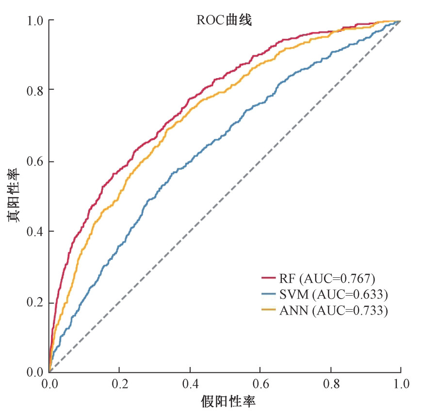
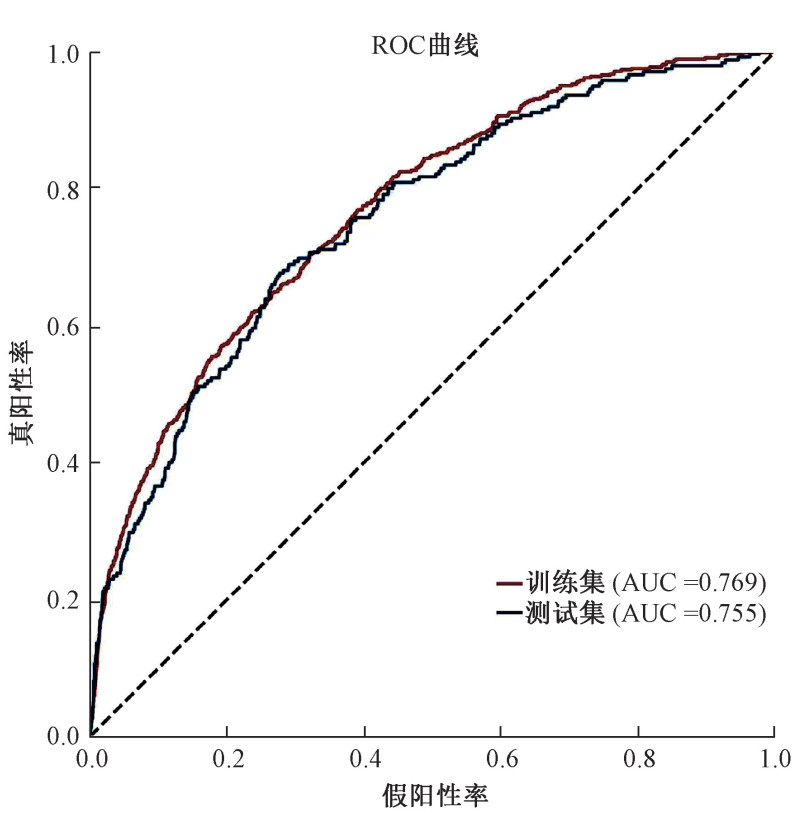
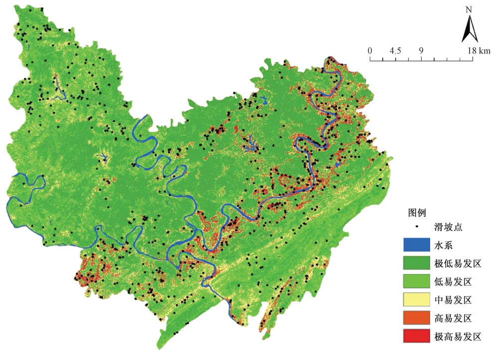
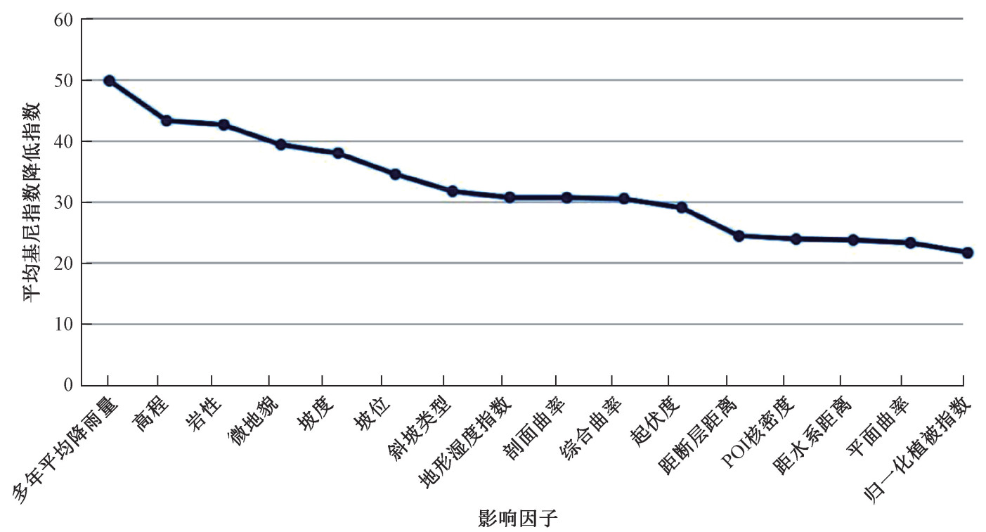
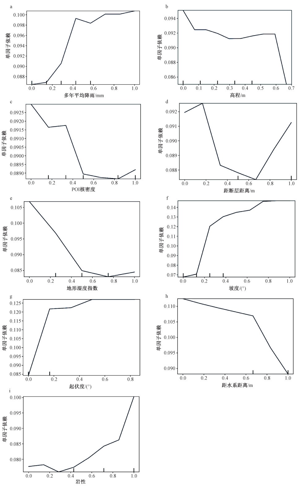
研究旨在基于随机森林-特征递归消除模型,通过SHAP算法(SHapley Additive exPlanation, SHAP)与部分依赖图(Partial Dependence Plot, PDP)对缓丘岭谷地貌区域进行滑坡易发性评价与内部机制解释,以期为地质灾害防治研究提供参考。利用优化随机森林算法对典型缓丘岭谷地区滑坡易发性进行研究,建立缓丘岭谷滑坡易发性评价模型;利用特征递归消除算法剔除噪声因子,选取地形地貌、地质构造、环境条件、人类活动5个类型16个因子构建重庆合川区滑坡致灾因子数据库;结合合川区754个历史滑坡点,利用随机森林算法对因子重要性进行排序,并根据专家经验法对研究区的滑坡易发性进行划分,将研究区的滑坡易发性分为极低、低、中、高、极高5个等级;应用部分依赖图对合川区滑坡发生影响大的因子进行解释和SHAP算法对个体滑坡进行局部解释。结果表明:与原模型相比,随机森林-特征递归消除模型测试集AUC值提高了0.019,证明了特征递归消除算法的有效性;训练集以及测试集的AUC值分别为0.769、0.755,具有较高的预测精度;缓丘缓坡地区在起伏较大地区滑坡密度较大,历史滑坡多集中于高易发地区;滑坡的空间分布具有不均匀性与复杂性,各致灾因子对滑坡发生的影响有着明显的区域特征与空间异质性,在缓坡丘陵地区多年平均降雨、高程、岩性3个因子对滑坡发生的影响最大;由SHAP算法对合川白塔坪上山公路滑坡事件进行解释,岩性与高程对滑坡起抑制作用,起伏度、坡度、归一化植被指数(NDVI)与POI核密度促进滑坡发生。综上所述,基于随机森林-特征递归消除模型在缓丘岭谷区滑坡易发性评价中具有较高的准确性,通过部分依赖图与SHAP算法对全局滑坡与个体滑坡发生的内在机理进行解释分析,有利于构建与完善不同地貌环境下滑坡易发性评价因子体系并探究滑坡内部决策机理,可为区域滑坡易发性评估与地质灾害防治提供参考。
Abstract:This study aims to evaluate landslide susceptibility and explain the internal mechanism of gentle hill-valley through SHAP partial interpretation and PDP partial dependency map based on the random forest-recursive feature elimination model to provide references for geological disaster prevention and control. We used the optimized random forest algorithm to analyze the landslide susceptibility of the specific hill-valley areas and established a landslide susceptibility evaluation model. The recursive feature elimination algorithm was used to eliminate noise factors. Sixteen factors of four types, including terrain, geology, environmental conditions, and human activities, were selected to build a landslide hazard factor database for the Hechuan district. Then we combined 754 historical landslide sites in the Hechuan district with the factor database to derive a landslide susceptibility zoning map for the study area, and the factor importance was ranked using the random forest algorithm. Finally, a partial dependency plot is applied to explain the factors strongly influencing landslide occurrence in the Hechuan district and the SHAP algorithm for a local explanation of individual landslides. The results show that: compared with the original model, the AUC value of the test set of the random forest-recursive feature elimination model has increased by 0.019, demonstrating the effectiveness of the recursive feature elimination algorithm. According to the evaluation results of the random forest model, the AUC values of the training set and the test set are 0.769 and 0.755, respectively, with high prediction accuracy. The density is high in areas with large undulations, and historical landslides are concentrated in high-susceptibility areas. The spatial distribution of landslides is uneven and complex, and the influence of each hazard factor on landslide occurrence has prominent regional characteristics and spatial heterogeneity. In hill-valley areas, the average annual rainfall, elevation, and lithology are the most critical factors affecting landslide occurrence. According to the local interpretation map of SHAP, the landslide on the uphill road of Baitaping is explained. The lithology and elevation played a role in restraining the landslide, and the undulation, slope, NDVI, and POI kernel density promoted the landslide. In summary, the random forest-recursive feature elimination model has high accuracy in landslide susceptibility evaluation in the hill-valley areas. The interpretation and analysis of the internal mechanism of the regional landslides and individual landslides through PDP and SHAP interpretation algorithms are conducive to constructing and improving the evaluation factor system for landslide susceptibility under different geomorphic environments. The internal decision-making mechanism of landslides is explored; it can provide a reference for the regional landslide susceptibility assessment and geological disaster prevention.
-

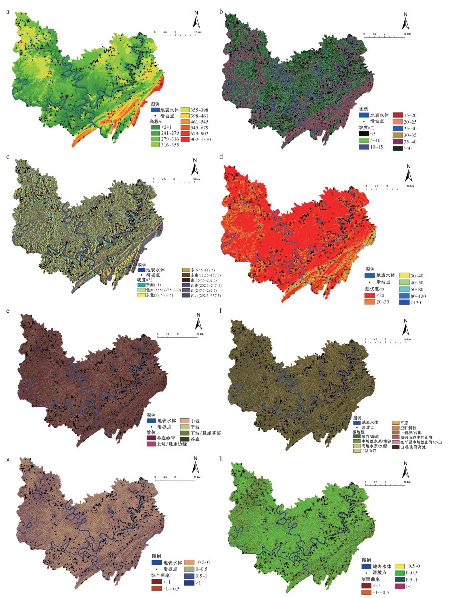
图 2 滑坡影响因子专题图(一)
a—高程;b—坡度;c—坡向;d—起伏度;e—坡位;f—微地貌;g—综合曲率;h—剖面曲率
Figure 2. Thematic layers of landslide influencing factors (PartⅠ)
(a) Elevation; (b) Slope; (c)Aspect; (d) RDLS; (e) Slope position; (f) Microtopography; (g) Curvature; (h) Profile curvature

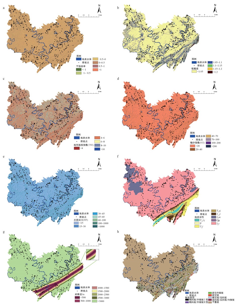
图 3 滑坡影响因子专题图(二)
a—平面曲率;b—粗糙度;c—地形湿度指数;d—输沙指数;e—水流动力指数;f—地层岩性;g—距断层距离;h—倾坡类型
Figure 3. Thematic layers of landslide influencing factors (PartⅡ)
(a) Plane curvature; (b) TRI; (c) TWI; (d) STI; (e) SPI; (f) Lithology; (g) Distance from fault; (h) CRDS

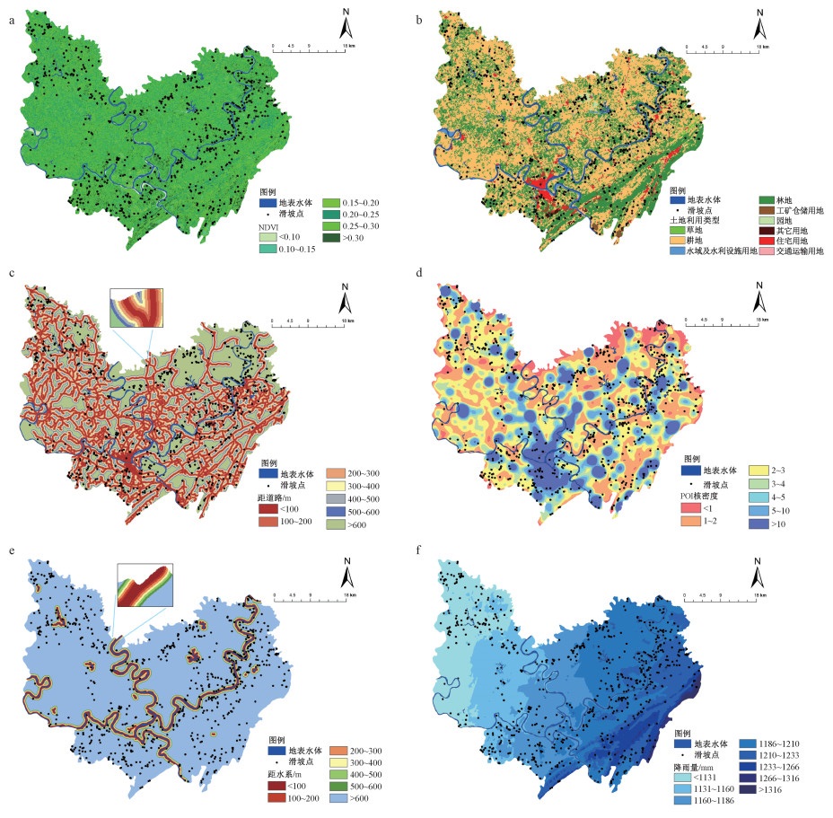
图 4 滑坡影响因子专题图(三)
a—NDVI;b—土地利用类型;c—距道路距离;d—POI核密度;e—距水系距离;f—年平均降雨量
Figure 4. Thematic layers of landslide influencing factors (Part Ⅲ)
(a) NDVI; (b) Land-use type; (c) Distance from road; (d) POI kernel density; (e) Distance from water system; (f) Average annual rainfall

图 5 随机森林算法流程示意图
Figure 5. Schematic diagram showing the process of the random forest algorithm

图 6 RF、SVM、ANN算法AUC值对比图
Figure 6. Comparison of AUC values of RF, SVM, and ANN algorithms

图 8 合川区滑坡易发区划图
Figure 8. Zoning map of the landslide susceptibility in the Hechuan district

图 11 部分因子依赖图
Figure 11. Partial Dependence Plot
(a) Average annual rainfall; (b) Elevation; (c) POI kernel density; (d) Distance from fault; (e) TWI; (f) Slope; (g)Relief; (h) Distance from river; (i)Lithology

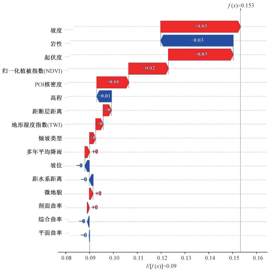
图 12 白塔坪上山公路滑坡瀑布图
蓝色部分表示特征与预测结果呈负相关,红色部分代表特征对预测结果有正向影响
Figure 12. Waterfull plot of the landslide on the Baitaping uphill road
The blue part indicates that the feature is negatively correlated with the predicted outcome, while the red part indicates that the feature has a positive effect on the predicted outcome
表 1 合川区各地貌滑坡分布表
Table 1. Distribution of landslides by landform in the Hechuan district
类型 丘陵 低山 中山 高山 面积/km2 1936.1 368.0 35.1 4.7 占比/% 82.6 15.7 1.5 0.2 滑坡个数 596 147 11 0 滑坡密度/(个/km2) 0.31 0.40 0.31 0  下载: 导出CSV
表 2 数据及来源
Table 2. Data and their sources
数据名称 数据来源 类型 精度 历史滑坡 重庆市地质监测站 数据表 —— DEM Aster卫星 栅格 30 m 地质资料 国家地质资料数据中心 栅格 1∶20万 土地利用 地理国情监测云平台 矢量 1∶10万 行政区划 地理国情监测云平台 矢量 1∶10万 河网 重庆市水利局 矢量 1∶10万 多年平均降雨量 地理国情监测云平台 栅格 30 m 道路 中国科学院资源环境科学数据中心 矢量 1∶10万 卫星影像 地理空间数据云平台 栅格 30 m POI 网络爬虫 数据表 ——
下载: 导出CSV
表 3 滑坡易发性影响因子分类
Table 3. Classification of influencing factors of landslide susceptibility
影响因子 分级数量 分类阈值或标准 高程/m 10 ①<241;②241~279;③79~316;④316~355;⑤355~398;⑥398~461;⑦461~545;⑧545~679;⑨679~902;⑩>902 坡度/(°) 9 ①<5;②5~10;③10~15;④15~20;⑤20~25;⑥25~30;⑦30~35;⑧35~40;⑨>40 坡向 9 ①平面;②北;③东北;④东;⑤东南;⑥南;⑦西南;⑧西;⑨西北 起伏度/m 7 ①<20;②20~30;③30~40;④40~50;⑤50~80;⑥80~120;⑦>120 坡位 6 ①山脊;②上坡/悬崖边缘;③中坡;④平坡;⑤下坡/悬崖基部;⑥谷底 微地貌 10 ①峡谷、深流;②中坡处水系、浅谷;③高地水系、水源;④U型山谷;⑤平原;⑥空旷斜坡;⑦上斜坡、台地;⑧局部山谷中的山脊;⑨平原中坡处山脊,小山;⑩山顶,山脊高处 综合曲率 6 ①<-1;②-1~-0.5;③-0.5~0;④0~0.5;⑤0.5~1;⑥>1 剖面曲率 6 ①<-1;②-1~-0.5;③-0.5~0;④0~0.5;⑤0.5~1;⑥>1 平面曲率 6 ①<-1;②-1~-0.5;③-0.5~0;④0~0.5;⑤0.5~1;⑥>1 粗糙度 5 ①<1.05;②1.05~1.1;③1.1~1.15;④1.15~1.2;⑤>1.2 地形湿度指数(TWI) 5 ①<4;②4~6;③ 6~8;④8~10;⑤>10 输沙指数(STI) 6 ①<20;② 20~40;③40~70;④70~100;⑤100~200;⑥>200 水流动力指数(SPI) 7 ①<15;②15~30;③30~45;④45~60;⑤60~100;⑥100~1000;⑦>1000 地层岩性 8 ①Tl f-j;②P;③T21;④T3xj;⑤J1-2z;⑥J3sn;⑦Qp;⑧J2s 距断层距离/m 7 ①<500;②50~1000;③1000~1500;④1500~2000;⑤2000~2500;⑥2500~3000;⑦>3000 倾坡类型 7 ①第Ⅰ型顺向坡/外倾坡;②斜交外倾坡;③斜交坡;④横交坡;⑤逆向坡;⑥第Ⅱ型顺向坡/外倾坡;⑦平叠坡 归一化植被指数(NDVI) 6 ①<0.10;②0.10~0.15;③0.15~0.20;④0.20~0.25;⑤0.25~0.30;⑥>0.30 土地利用类型 9 ①草地;②耕地;③水域及水利设施用地;④林地;⑤工矿仓储用地;⑥园地;⑦其他用地;⑧住宅用地;⑨交通运输用地 距道路距离/m 7 ①<100;②100~200;③200~300;④300~400;⑤400~500;⑥500~600;⑦>600 POI核密度/(个/15×15 km2) 7 ①<1;②1~2;③2~3;④3~4;⑤ 4~5;⑥5~10;⑦>10 距水系距离/m 7 ①<100;②100~200;③200~300;④300~400;⑤400~500;⑥500~600;⑦>600 年平均降雨量/mm 8 ①<1131;②1131~1160;③1160~1186;④1186~1210;⑤1210~1233;⑥1233~1266;⑦1266~1316;⑧>1316
下载: 导出CSV
表 4 测试集AUC值变化表
Table 4. AUC value change table of the test set
未剔除 第1次剔除 第2次剔除 第3次剔除 第4次剔除 第5次剔除 第6次剔除 剔除因子 输沙指数 坡向 地面粗糙度 距道路距离 土地利用类型 水流动力指数 测试集AUC值 0.752 0.758 0.760 0.765 0.764 0.766 0.771
下载: 导出CSV
表 5 十折交叉验证的准确性
Table 5. Accuracy of the ten-fold cross-validation method
样本 精确度 样本 精确度 准确性 AUC(训练集) AUC(测试集) 准确性 AUC(训练集) AUC(测试集) 1 0.9056 0.7854 0.7200 6 0.9084 0.7769 0.7470 2 0.9076 0.7817 0.7361 7 0.9113 0.7821 0.7245 3 0.9152 0.7705 0.7534 8 0.9149 0.7734 0.7357 4 0.9141 0.7801 0.7335 9 0.9113 0.7825 0.7318 5 0.9080 0.7833 0.7186 10 0.9000 0.7794 0.7491
下载: 导出CSV
表 6 滑坡易发性区划分级统计表
Table 6. Classification table of landslide susceptibility
滑坡概率 易发性分级 栅格个数/个 面积比/% 滑坡个数/个 滑坡占比/% 滑坡密度/(个/km2) <0.06 极低易发区 1175389 45.58 41 5.44 0.039 0.06~0.14 低易发区 791083 30.68 74 9.81 0.104 0.14~0.24 中易发区 373736 14.49 80 10.61 0.238 0.24~0.38 高易发区 174718 6.78 91 12.07 0.579 >0.38 极高易发区 63634 2.47 468 62.07 8.172
下载: 导出CSV
-
ACHOUR Y, BOUMEZBEUR A, HADJI R, et al., 2017. Landslide susceptibility mapping using analytic hierarchy process and information value methods along a highway road section in Constantine, Algeria[J]. Arabian Journal of Geosciences, 10(8): 194. doi: 10.1007/s12517-017-2980-6 BREIMAN L, 1996. Bagging predictors[J]. Machine Learning, 24(2): 123-140. BRILL F, PASSUNI PINEDA S, ESPICHÁN CUYA B, et al., 2020. A data-mining approach towards damage modelling for El Niño events in Peru[J]. Geomatics, Natural Hazards and Risk, 11(1): 1966-1990. doi: 10.1080/19475705.2020.1818636 BUAH P A, ZHANG Y B, BAKAH D A Y, et al., 2019. Earthquake-induced landslide susceptibility analysis: The effect of DEM resolution[C]//2019 International Conference on Mechatronics, Remote Sensing, Information Systems and Industrial Information Technologies (ICMRSISIIT). Ghana: IEEE, 2019: 1-5. CAN A, DAGDELENLER G, ERCANOGLU M, et al., 2019. Landslide susceptibility mapping at Ovacık-Karabük (Turkey) using different artificial neural network models: Comparison of training algorithms[J]. Bulletin of Engineering Geology and the Environment, 78: 89-102. doi: 10.1007/s10064-017-1034-3 CHEN W, POURGHASEMI H R, ZHAO Z, 2017. A GIS-based comparative study of Dempster-Shafer, logistic regression and artificial neural network models for landslide susceptibility mapping[J]. Geocarto International, 32(4): 367-385. doi: 10.1080/10106049.2016.1140824 CHEN W, PENG J B, HONG H Y, et al., 2018. Landslide susceptibility modelling using GIS-based machine learning techniques for Chongren County, Jiangxi Province, China[J]. Science of the Total Environment, 626: 1121-1135. doi: 10.1016/j.scitotenv.2018.01.124 CHEN W, CHEN X, PENG J B, et al., 2021. Landslide susceptibility modeling based on ANFIS with teaching-learning-based optimization and Satin bowerbird optimizer[J]. Geoscience Frontiers, 12(1): 93-107. doi: 10.1016/j.gsf.2020.07.012 CRAMER H, EVERS V, RAMLAL S, et al., 2008. The effects of transparency on trust in and acceptance of a content-based art recommender[J]. User Modeling and User-Adapted Interaction, 18(5): 455-496. doi: 10.1007/s11257-008-9051-3 DAS I, STEIN A, KERLE N, et al., 2012. Landslide susceptibility mapping along road corridors in the Indian Himalayas using Bayesian logistic regression models[J]. Geomorphology, 179: 116-125. doi: 10.1016/j.geomorph.2012.08.004 DAS J, KUMAR S, MISHRA D C, et al., 2023. Machine learning in the estimation of CRISPR-Cas9 cleavage sites for plant system[J]. Frontiers in Genetics, 13: 1085332. doi: 10.3389/fgene.2022.1085332 DIKSHIT A, PRADHAN B, ALAMRI A M, 2021. Pathways and challenges of the application of artificial intelligence to geohazards modelling[J]. Gondwana Research, 100: 290-301. doi: 10.1016/j.gr.2020.08.007 DOU J, YUNUS A P, TIEN BUI D, et al., 2019. Assessment of advanced random forest and decision tree algorithms for modeling rainfall-induced landslide susceptibility in the Izu-Oshima Volcanic Island, Japan[J]. Science of the Total Environment, 662: 332-346. doi: 10.1016/j.scitotenv.2019.01.221 EKMEKCIOǦLU Ö, KOC K, 2022. Explainable step-wise binary classification for the susceptibility assessment of geo-hydrological hazards[J]. CATENA, 216: 106379. doi: 10.1016/j.catena.2022.106379 FRIEDMAN J H, 2001. Greedy function approximation: A gradient boosting machine[J]. The Annals of Statistics, 29(5): 1189-1232. doi: 10.1214/aos/1013203450 HERLOCKER J L, KONSTAN J A, RIEDL J, 2000. Explaining collaborative filtering recommendations[C]//Proceedings of the 2000 ACM Conference on Computer Supported Cooperative Work. Philadelphia: Association for Computing Machinery: 241-250. HONG H Y, SHAHABI H, SHIRZADI A, et al., 2019. Landslide susceptibility assessment at the Wuning area, China: A comparison between multi-criteria decision making, bivariate statistical and machine learning methods[J]. Natural Hazards, 96: 173-212. doi: 10.1007/s11069-018-3536-0 HUANG F M, YIN K L, HUANG J S, et al., 2017. Landslide susceptibility mapping based on self-organizing-map network and extreme learning machine[J]. Engineering Geology, 223: 11-22. doi: 10.1016/j.enggeo.2017.04.013 HUANG F M, CHEN J W, DU Z, et al., 2020. Landslide susceptibility prediction considering regional soil erosion based on machine-learning models[J]. ISPRS International Journal of Geo-Information, 9(6): 377. doi: 10.3390/ijgi9060377 KALANTAR B, PRADHAN B, NAGHIBI S A, et al., 2018. Assessment of the effects of training data selection on the landslide susceptibility mapping: A comparison between support vector machine (SVM), logistic regression (LR) and artificial neural networks (ANN)[J]. Geomatics, Natural Hazards and Risk, 9(1): 49-69. doi: 10.1080/19475705.2017.1407368 KAVZOGLU T, SAHIN E K, COLKESEN I, 2015. Selecting optimal conditioning factors in shallow translational landslide susceptibility mapping using genetic algorithm[J]. Engineering Geology, 192: 101-112. doi: 10.1016/j.enggeo.2015.04.004 KURADUSENGE M, KUMARAN S, ZENNARO M, 2020. Rainfall-induced landslide prediction using machine learning models: The case of Ngororero District, Rwanda[J]. International Journal of Environmental Research and Public Health, 17(11): 4147. doi: 10.3390/ijerph17114147 LIU C Z, WEN M S, TANG C, 2004. Meteorological early warning of geo-hazards in China based on raining forecast[J]. Geological Bulletin of China, 23(4): 303-309. (in Chinese with English abstract) doi: 10.3969/j.issn.1671-2552.2004.04.001 LIU R, SHI S X, SUN D L, et al., 2020. Based on GIS and random forest model for landslide susceptibility mapping in Wushan County[J]. Journal of Chongqing Normal University (Natural Science), 37(3): 86-96. (in Chinese with English abstract) LUNDBERG S M, LEE S I, 2017. A unified approach to interpreting model predictions[C]//Proceedings of the 31st International Conference on Neural Information Processing Systems. Long Beach: Curran Associates Inc. : 4768-4777. MARJANOVIĆ M, KOVAǦEVIĆ M, BAJAT B, et al., 2011. Landslide susceptibility assessment using SVM machine learning algorithm[J]. Engineering Geology, 123(3): 225-234. doi: 10.1016/j.enggeo.2011.09.006 MILNE F D, BROWN M J, KNAPPETT J A, et al., 2012. Centrifuge modelling of hillslope debris flow initiation[J]. CATENA, 92: 162-171. doi: 10.1016/j.catena.2011.12.001 MOAYEDI H, MEHRABI M, MOSALLANEZHAD M, et al., 2019. Modification of landslide susceptibility mapping using optimized PSO-ANN technique[J]. Engineering with Computers, 35(3): 967-984. doi: 10.1007/s00366-018-0644-0 MOOSAVI V, NIAZI Y, 2016. Development of hybrid wavelet packet-statistical models (WP-SM) for landslide susceptibility mapping[J]. Landslides, 13: 97-114. doi: 10.1007/s10346-014-0547-0 NAGHIBI S A, AHMADI K, DANESHI A, 2017. Application of support vector machine, random forest, and genetic algorithm optimized random forest models in groundwater potential mapping[J]. Water Resources Management, 31(9): 2761-2775. doi: 10.1007/s11269-017-1660-3 NGO P T T, PANAHI M, KHOSRAVI K, et al., 2021. Evaluation of deep learning algorithms for national scale landslide susceptibility mapping of Iran[J]. Geoscience Frontiers, 12(2): 505-519. doi: 10.1016/j.gsf.2020.06.013 PHAM B T, NGUYEN-THOI T, QI C C, et al., 2020. Coupling RBF neural network with ensemble learning techniques for landslide susceptibility mapping[J]. CATENA, 195: 104805. doi: 10.1016/j.catena.2020.104805 REICHENBACH P, ROSSI M, MALAMUD B D, et al., 2018. A review of statistically-based landslide susceptibility models[J]. Earth-Science Reviews, 180: 60-91. doi: 10.1016/j.earscirev.2018.03.001 SAHIN E K, COLKESEN I, KAVZOGLU T, 2020. A comparative assessment of canonical correlation forest, random forest, rotation forest and logistic regression methods for landslide susceptibility mapping[J]. Geocarto International, 35(4): 341-363. doi: 10.1080/10106049.2018.1516248 STUMPF A, KERLE N, 2011. Object-oriented mapping of landslides using random forests[J]. Remote Sensing of Environment, 115(10): 2564-2577. doi: 10.1016/j.rse.2011.05.013 SUN D L, 2019. Mapping landslide susceptibility based on machine learning and forecast warning of landslide induced by rainfall[D]. Shanghai: East China Normal University. (in Chinese with English abstract) SUN D L, WEN H J, WANG D Z, et al., 2020a. A random forest model of landslide susceptibility mapping based on hyperparameter optimization using Bayes algorithm[J]. Geomorphology, 362: 107201. doi: 10.1016/j.geomorph.2020.107201 SUN D L, XU J H, WEN H J, et al., 2020b. An optimized random forest model and its generalization ability in landslide susceptibility mapping: Application in two areas of Three Gorges Reservoir, China[J]. Journal of Earth Science, 31(6): 1068-1086. doi: 10.1007/s12583-020-1072-9 SUN D L, SHI S X, WEN H J, et al., 2021a. A hybrid optimization method of factor screening predicated on GeoDetector and random forest for landslide susceptibility mapping[J]. Geomorphology, 379: 107623. doi: 10.1016/j.geomorph.2021.107623 SUN D L, XU J H, WEN H J, et al., 2021b. Assessment of landslide susceptibility mapping based on Bayesian hyperparameter optimization: A comparison between logistic regression and random forest[J]. Engineering Geology, 281: 105972. doi: 10.1016/j.enggeo.2020.105972 SUN D L, DING Y K, ZHANG J L, et al., 2022. Essential insights into decision mechanism of landslide susceptibility mapping based on different machine learning models[J]. Geocarto International, 1-29. TIAN Y Y, XU C, HONG H Y, et al., 2019. Mapping earthquake-triggered landslide susceptibility by use of artificial neural network (ANN) models: An example of the 2013 Minxian (China) Mw 5.9 event[J]. Geomatics, Natural Hazards and Risk, 10(1): 1-25. doi: 10.1080/19475705.2018.1487471 WANG Y, FANG Z C, HONG H Y, 2019. Comparison of convolutional neural networks for landslide susceptibility mapping in Yanshan County, China[J]. Science of the Total Environment, 666: 975-993. doi: 10.1016/j.scitotenv.2019.02.263 WANG Y, SUN D L, WEN H J, et al., 2020. Comparison of random forest model and frequency ratio model for landslide susceptibility mapping (LSM) in Yunyang County (Chongqing, China)[J]. International Journal of Environmental Research and Public Health, 17(12): 4206. doi: 10.3390/ijerph17124206 WANG Y, WEN H J, SUN D L, et al, 2021. Quantitative Assessment of Landslide Risk Based on Susceptibility Mapping Using Random Forest and GeoDetector [J]. Remote Sensing, 13(13). WU J H, ZHANG C S, MENG H J, et al., 2021. Temporal and spatial characteristics of landslide susceptibility in the west open-pit mining area, Fushun, China[J]. Journal of Geomechanics, 27(3): 409-417. (in Chinese with English abstract) WU C W, LIANG J H, WANG W, et al., 2017. Random Forest Algorithm Based on Recursive Feature Elimination[J]. Statistics & Decision, 489(21): 60-63. (in Chinese with English abstract) XIE C Y, 2011. Landslides hazard susceptibility evaluation based on weighting model[J]. Journal of Central South University (Science and Technology), 42(6): 1772-1779. (in Chinese with English abstract) YANG J T, SONG C, YANG Y, et al., 2019. New method for landslide susceptibility mapping supported by spatial logistic regression and GeoDetector: A case study of Duwen Highway Basin, Sichuan Province, China[J]. Geomorphology, 324: 62-71. doi: 10.1016/j.geomorph.2018.09.019 YANG Y G, YIN K L, ZHAO H Y, et al., 2019. Landslide susceptibility evaluation for township units of bank section in Wanzhou District based on C5.0 decision tree and K-means cluster model[J]. Geological Science and Technology Information, 38(6): 189-197. (in Chinese with English abstract) YI Y N, ZHANG Z J, ZHANG W C, et al., 2020. Landslide susceptibility mapping using multiscale sampling strategy and convolutional neural network: A case study in Jiuzhaigou region[J]. CATENA, 195: 104851. doi: 10.1016/j.catena.2020.104851 ZHANG H, GAO Y, LI B, et al., 2022. Numerical simulation analysis of the solid-liquid coupling process in a hybrid landslide: A case study of the Wushanping landslide[J]. Journal of Geomechanics, 28(6): 1104-1114. (in Chinese with English abstract) ZHANG Y L, WEN H J, XIE P, et al., 2021. Hybrid-optimized logistic regression model of landslide susceptibility along mountain highway[J]. Bulletin of Engineering Geology and the Environment, 80(10): 7385-7401. doi: 10.1007/s10064-021-02415-y ZHOU X Z, WEN H J, ZHANG Y L, et al., 2021. Landslide susceptibility mapping using hybrid random forest with GeoDetector and RFE for factor optimization[J]. Geoscience Frontiers, 12: 101211. doi: 10.1016/j.gsf.2021.101211 ZHOU X Z, WEN H J, LI Z W, et al., 2022. An interpretable model for the susceptibility of rainfall-induced shallow landslides based on SHAP and XGBoost[J]. Geocarto International, 37(26): 13419-13450. doi: 10.1080/10106049.2022.2076928 刘传正, 温铭生, 唐灿, 2004. 中国地质灾害气象预警初步研究[J]. 地质通报, 23(4): 303-309. doi: 10.3969/j.issn.1671-2552.2004.04.001 刘睿, 施婌娴, 孙德亮, 等, 2020. 基于GIS与随机森林的巫山县滑坡易发性区划[J]. 重庆师范大学学报(自然科学版), 37(3): 86-96. https://www.cnki.com.cn/Article/CJFDTOTAL-CQSF202003012.htm 孙德亮, 2019. 基于机器学习的滑坡易发性区划与降雨诱发滑坡预报预警研究[D]. 上海: 华东师范大学. 吴辰文, 梁靖涵, 王伟, 等, 2017. 基于递归特征消除方法的随机森林算法[J]. 统计与决策, 489(21): 60-63. 吴季寰, 张春山, 孟华君, 等, 2021. 抚顺西露天矿区滑坡易发性评价与时空特征分析[J]. 地质力学学报, 27(3): 409-417. doi: 10.12090/j.issn.1006-6616.2021.27.03.037 解传银, 2011. 基于权重模型的滑坡灾害敏感性评价[J]. 中南大学学报(自然科学版), 42(6): 1772-1779. 杨永刚, 殷坤龙, 赵海燕, 等, 2019. 基于C5.0决策树-快速聚类模型的万州区库岸段乡镇滑坡易发性区划[J]. 地质科技情报, 38(6): 189-197. https://www.cnki.com.cn/Article/CJFDTOTAL-DZKQ201906023.htm 张晗, 高杨, 李滨, 等, 2022. 复合型滑坡固液耦合过程数值模拟分析: 以无山坪滑坡为例[J]. 地质力学学报, 28(6): 1104-1114. doi: 10.12090/j.issn.1006-6616.20222832 -

 下载:
下载:


计量
- 文章访问数: 1845
- HTML全文浏览量: 530
- PDF下载量: 127
- 被引次数: 0
