

Development characteristics and risk assessment of geological hazards in the mountainous and hilly areas of western Zhengzhou City
-
摘要: 郑州市西部山地丘陵区地质环境条件复杂,崩塌、滑坡及泥石流等地质灾害频发,尤其是2021年“7·20”特大暴雨引发了大量地质灾害。地质灾害危险性评价主要采用单一方法进行,存在评价准确性略低等问题。通过对研究区地质环境背景、地质灾害分布特征的分析研究,选取坡度、地貌、工程地质岩组、高程、距断裂距离、距河流距离、24 小时最大降雨量和人类工程活动强度8个评价因子,采用加权信息量法,对研究区进行地质灾害危险性评价。结果表明:低、中、高危险区面积分别为1387.14 km2、1803.18 km2、1066.47 km2,分别占总面积的32.59%、42.36%、25.05%,地质灾害点的空间分布与地质灾害危险性评价结果基本一致,利用受试者工作特征(ROC)曲线检验评价结果合理,研究结论可为郑州市西部山地丘陵区地质灾害防治提供准确的依据。Abstract:
Objective The mountainous and hilly areas of western Zhengzhou City have a complex geological environment, affected by rainfall and human engineering activities. Geological hazards such as collapses, landslides, and debris flows occur frequently. In particular, the “7·20” extreme rainstorm that occurred on July 20, 2021 caused many geological hazards, resulting in heavy casualties and huge economic losses. Therefore, analyzing and summarizing the development characteristics of geological hazards and conducting a risk assessment is necessary for this region. At present, the risk assessment of geological hazards is mainly conducted using a single method that has limitations including slightly low evaluation accuracy. In addition, an overall geological hazard risk assessment has not yet been conducted in the mountainous and hilly areas of western Zhengzhou City. Methods Based on the research and analysis of the geological environment background and the distribution characteristics of geological hazards in the study area, eight evaluation factors were selected: slope, landform, engineering geological rock group, elevation, distance from fault, distance from river, rainfall, and human engineering activities. The weighted information method which incorporates elements of the information quantity model and analytic hierarchy process, was used to evaluate the risk of geological hazards in the study area. Results The low-, medium-, and high-risk areas are 1387.14 km2, 1803.18 km2, and 1066.47 km2, respectively, accounting for 32.59%, 42.36%, and 25.05% of the total area, respectively. The medium- and high-risk areas are mainly distributed in the tectonic erosion medium-low mountains and loess hills in the central part of the four cities, the tectonic erosion medium-low mountains south of Dengfeng, and the loess hilly areas in northern Gongyi and Xingyang. The terrain has steep slopes and deep gullies, and the main stratigraphic lithology is clastic rocks intercalated with carbonate rocks, soft and hard rock layers, and loess. Fault structures are developed, and geological hazards are prone to occur under the action of inducing factors and are highly dangerous. The majority (93.11%) of geological hazards are distributed in medium- and high-risk areas, with hazard point densities of 0.1752 km−2 and 0.2869 km−2, respectively. The spatial distribution of geological hazard points is consistent with the geological hazard risk assessment results. The rationality of the evaluation results was assessed by a Receiver Operating Characteristic curve, yielding an AUC value of 0.868. The evaluation accuracy met the requirements for hazard assessment. Conclusion Geological hazards have the largest information value in the range of >40° slopes loess hilly landforms, loess engineering geological rock groups, and 24-h maximum rainfall of 500–550 mm. The risk of geological hazards is positively correlated with distance from faults and water systems — the closer the distance, the higher the risk. The risk of geological disasters in the study area is controlled by the terrain slope and landform and is closely related to the lithology of the formation, which is an important factor in inducing geological disasters. The weighted information method, which has high accuracy and rationality, was used to evaluate the geological hazard risk. Significance The results of this study can provide a basis and technical support for geological hazard prevention and management in the mountainous and hilly areas of western Zhengzhou City and serve as a valuable point of reference for urban planning and infrastructure geological hazard risk assessment in the study area. -

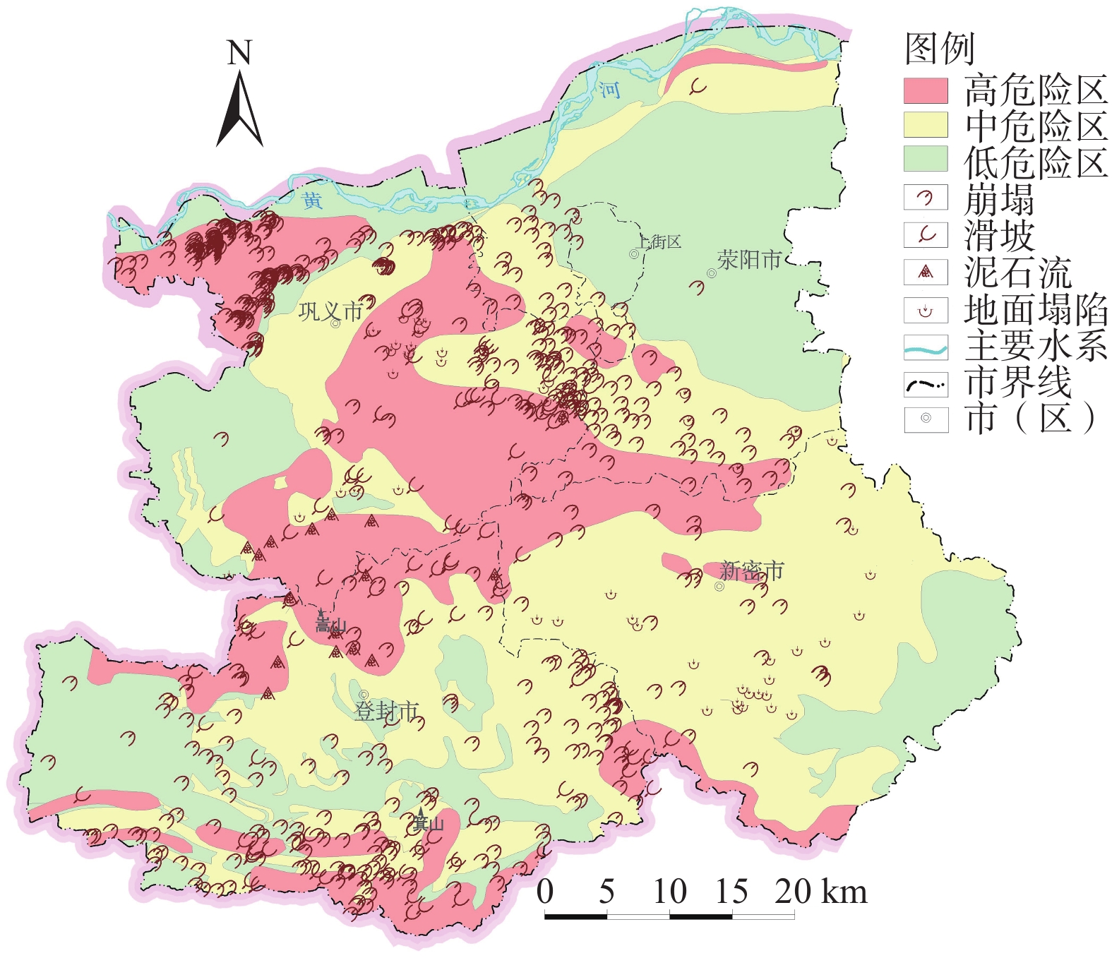
图 1 研究区地质灾害隐患点分布图
Figure 1. Distribution map of geological hazard hidden danger points in the study area

图 2 地质灾害危险性评价影响因子分级图
a—坡度;b—地貌;c—工程地质岩组;d—高程;e—距断裂距离;f—距河流距离;g—24小时最大降雨量;h—人类工程活动强度
Figure 2. Grading map of influencing factors of geological hazard risk assessment
a—slope; b—landform; c—engineering geological rock group; d—elevation; e—distance from fault; f—distance from river; g—24-h maximum rainfall; h— human engineering activity factors

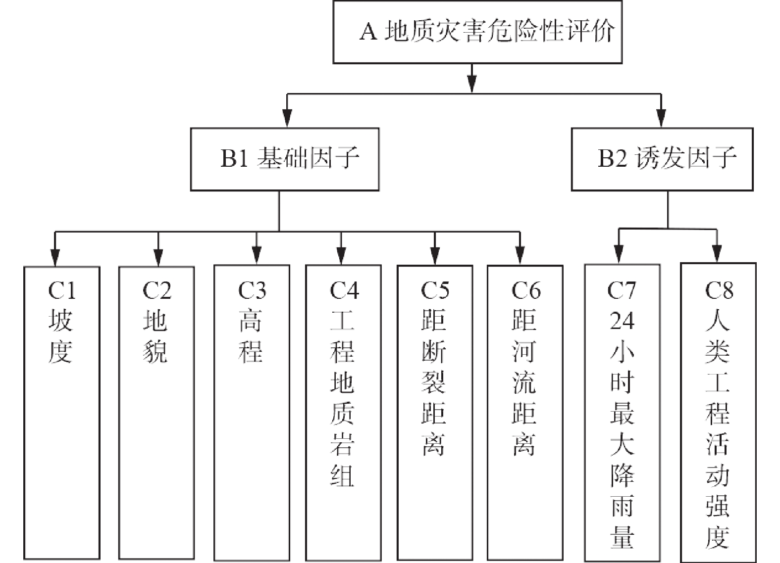
图 3 地质灾害危险性评价层次结构图
Figure 3. Hierarchical structure diagram of geological hazard risk assessment
表 1 研究区地质灾害隐患点统计表
Table 1. Statistical table of geological hazard hidden danger points in the study area
灾害类型 灾害点/处 百分比/% 威胁人数/人 威胁财产/万元 崩塌 502 75.1 25955 79638 滑坡 97 14.5 3790 8117 泥石流 17 2.6 2554 12806 地面塌陷 52 7.8 2895 8964 合计 668 100.0 35194 109525  下载: 导出CSV
表 2 A-B判断矩阵及权重
Table 2. A-B judgment matrix and weight
A B1 B2 Wi B1 1 5 0.8333 B2 1/5 1 0.1667 λmax=2,CI=0,RI=0,CR=0<0.1
注:Wi—第i个评价因子的权重;λmax—判断矩阵最大特征值;CI—一致性指标;RI—随机一致性指标;CR—一致性比率,若 CR<0.1,则认为判断矩阵通过一致性检验,所求权重值是合理的,下表同。
下载: 导出CSV
表 3 B1-C判断矩阵及权重
Table 3. B1-C judgment matrix and weight
B1 C1 C2 C3 C4 C5 C6 Wi C1 1 5 6 3 8 7 0.4651 C2 1/5 1 2 1/2 4 3 0.1305 C3 1/6 1/2 1 1/4 3 2 0.0823 C4 1/3 2 4 1 6 5 0.2324 C5 1/8 1/4 1/3 1/6 1 1/2 0.0361 C6 1/7 1/3 1/2 1/5 2 1 0.0537 λmax=6.1780, CI=0.0356, RI=1.26,CR=0.0283<0.1
下载: 导出CSV
表 4 B2-C判断矩阵及权重
Table 4. B2-C judgment matrix and weight
B2 C7 C8 Wi C7 1 4 0.8 C8 1/4 1 0.2 λmax=2, CI=0, RI=0 ,CR=0<0.1
下载: 导出CSV
表 5 A-C层次总权重排序
Table 5. Ranking of the total weights of layers A-C
A B A-B权重 C B-C权重 A-C权重 地质灾害危险性评价 B1
0.8333C1 0.4651 0.3876 C2 0.1305 0.1087 C3 0.0823 0.0686 C4 0.2324 0.1937 C5 0.0361 0.0301 C6 0.0537 0.0446 B2 0.1667 C7 0.8000 0.1334 C8 0.2000 0.0333 CR=(0.8333×0.0356+0.1667×0)/(0.8333×1.26+0.1667×0)=0.0283<0.1
下载: 导出CSV
表 6 地质灾害危险性评价因子加权信息量表
Table 6. Weighted information scale of geological hazard risk evaluation factors
评价因子 分级 Ni Ni/N Si Si/S 信息量 权重 加权信息量 地形坡度/(°) 0~10 141 0.2111 3026.94 0.7111 −1.2146 0.3876 −0.4708 10~25 428 0.6407 1073.4301 0.2522 0.9325 0.3614 25~40 89 0.1332 146.2915 0.0344 1.3550 0.5252 >40 10 0.0150 10.1339 0.0024 1.8387 0.7127 地貌 冲洪积倾斜平原 21 0.0314 775.0863 0.1821 −1.7565
0.1087−0.1909 黄河河漫滩 2 0.0030 225.2701 0.0529 −2.8722 −0.3122 山间洪积平原 47 0.0704 379.7426 0.0892 −0.2374 −0.0258 河谷阶地 68 0.1018 335.1929 0.0787 0.2568 0.0279 黄土丘陵 319 0.4775 1379.5019 0.3241 0.3877 0.0421 构造剥蚀丘陵 40 0.0599 185.4328 0.0436 0.3182 0.0346 构造侵蚀中低山 171 0.2560 976.5689 0.2294 0.1096 0.0119 高程/m <200 171 0.2560 1317.3781 0.3095 −0.1898 0.0686 −0.0130 200~400 304 0.4551 1752.2913 0.4116 0.1003 0.0069 400~600 154 0.2305 812.9577 0.1910 0.1883 0.0129 600~800 29 0.0434 249.9416 0.0587 −0.3019 −0.0207 800~1000 5 0.0075 91.2935 0.0214 −1.0527 −0.0722 >1000 5 0.0075 32.9333 0.0077 −0.0331 −0.0023 工程地质岩组 一般土 67 0.1003 1099.9754 0.2584 −0.9464 0.1937 −0.1833 碳酸盐岩 87 0.1302 692.5129 0.1627 −0.2224 −0.0431 坚硬−较坚硬岩 68 0.1018 469.6385 0.1103 −0.0805 −0.0156 软弱层状碎屑岩 42 0.0629 329.4227 0.0774 −0.2077 −0.0402 软硬相间变质岩 37 0.0554 216.7597 0.0509 0.0841 0.0163 碎屑岩夹碳酸盐岩 26 0.0389 114.5522 0.0269 0.3690 0.0715 黄土 341 0.5105 1333.9341 0.3134 0.4880 0.0945 距断裂距离/m >2000 402 0.6018 3011.4432 0.7074 −0.1617 0.0301 −0.0049 1000~2000 121 0.1811 583.7909 0.1371 0.2782 0.0084 500~1000 68 0.1018 324.3219 0.0762 0.2898 0.0087 <500 77 0.1153 337.2395 0.0792 0.3750 0.0113 距河流距离/m >800 436 0.6527 3294.3728 0.7739 −0.1703 0.0446 −0.0076 500~800 71 0.1063 332.0601 0.0780 0.3093 0.0138 200~500 80 0.1198 368.1142 0.0865 0.3256 0.0145 <200 81 0.1213 262.2484 0.0616 0.6771 0.0302 24小时最大降雨量/mm 225~300 76 0.1138 893.4056 0.2099 −0.6123 0.1334 −0.0817 300~350 87 0.1302 792.6438 0.1862 −0.3575 −0.0477 350~400 263 0.3937 1435.6581 0.3373 0.1548 0.0207 400~450 125 0.1871 626.8523 0.1473 0.2396 0.0320 450~500 74 0.1108 391.6921 0.0920 0.1856 0.0248 500~550 43 0.0644 116.5436 0.0274 0.8549 0.1140 人类工程活动强度 微弱 129 0.1931 1445.3425 0.3395 −0.5643 0.0333 −0.0188 一般 34 0.0509 252.7182 0.0594 −0.1539 −0.0051 较强 221 0.3308 1230.7963 0.2891 0.1347 0.0045 强烈 284 0.4251 1327.9385 0.3120 0.3096 0.0103
下载: 导出CSV
表 7 地质灾害危险性评价结果统计表
Table 7. Statistical table of geological disaster risk assessment results
危险性分区 灾害点/
个灾点占
比/%面积/
km2面积占
比/%灾点密度/
个/ km2低危险区 46 6.89 1387.14 32.59 0.0332 中危险区 316 47.30 1803.18 42.36 0.1752 高危险区 306 45.81 1066.47 25.05 0.2869
下载: 导出CSV
-
[1] ALI S, BIERMANNS P, HAIDER R, et al., 2019. Landslide susceptibility mapping by using a geographic information system (GIS) along the China-Pakistan Economic Corridor (Karakoram Highway), Pakistan[J]. Natural Hazards and Earth System Sciences, 19(5): 999-1022. doi: 10.5194/nhess-19-999-2019 [2] CHEN G Y, WANG L, JIAO H J, et al. , 2009. Environmental geological survey and evaluation report of major cities in Henan Province (Zhengzhou City)[R]. Zhengzhou: Henan Geological Survey Institute. (in Chinese) [3] CLERICI A, PEREGO S, TELLINI C, et al., 2002. A procedure for landslide susceptibility zonation by the conditional analysis method[J]. Geomorphology, 48(4): 349-364. doi: 10.1016/S0169-555X(02)00079-X [4] DENG H, HE Z W, CHEN Y, et al., 2014. Application of information quantity model to hazard evaluation of geological disaster in mountainous region environment: a case study of Luding County, Sichuan Province[J]. Journal of Natural Disasters, 23(2): 67-76. (in Chinese with English abstract [5] DING L, LI Z X, LI X W, et al., 2016. AHP-based assessment of geological hazards risk in Dengfeng city[J]. Journal of Geological Hazards and Environment Preservation, 27(2): 92-96. (in Chinese with English abstract [6] DU C L, LU W F, LI J F, et al., 2008. Analysis on the hazard degree of geological disasters[J]. Chinese Journal of Underground Space and Engineering, 4(6): 1169-1176. (in Chinese with English abstract [7] DU G L, ZHANG Y S, GAO J C, et al., 2016. Landslide susceptibility assessment based on GIS in Bailongjiang watershed, Gansu Province[J]. Journal of Geomechanics, 22(1): 1-11. (in Chinese with English abstract [8] FAN Z Y, GOU X F, QIN M Y, et al., 2018. Information and logistic regression models based coupling analysis for susceptibility of geological hazards[J]. Journal of Engineering Geology, 26(2): 340-347. (in Chinese with English abstract [9] FENG W, TANG Y M, MA H N, et al., 2021. Comprehensive risk assessment of multi-hazard natural disasters in Xianyang City based on AHP[J]. Northwestern Geology, 54(2): 282-288. (in Chinese with English abstract [10] HUANG R Q, XU X N, TANG C, et al. , 2008. Geological environment assessment and geological hazards management[M]. Beijing: Science Press: 151-179. (in Chinese) [11] Investigation Group on Disaster of State Council of China, 2022. Investigation report on the “7.20” extraordinary rainstorm disaster in Zhengzhou city, Henan province[R]. Beijing: Ministry of Emergency Management of the People’s Republic of China. (in Chinese) [12] LANG Q L, ZHANG Y C, ZHANG J Q, et al., 2019. Analysis of debris flow hazard factors based on combination weighting theory[J]. Journal of Catastrophology, 34(1): 68-72. (in Chinese with English abstract [13] LI C Y, MENG H, ZHANG R L, et al., 2017. Risk assessment of geo-hazard of China in county unit[J]. Hydrogeology & Engineering Geology, 44(2): 160-166. (in Chinese with English abstract [14] LI L P, LAN H X, GUO C B, et al., 2017. Geohazard susceptibility assessment along the Sichuan-Tibet railway and its adjacent area using an improved frequency ratio method[J]. Geoscience, 31(5): 911-929. (in Chinese with English abstract [15] LI X, XUE G C, LIU C Z, et al., 2022. Evaluation of geohazard susceptibility based on information value model and information value-logistic regression model: a case study of the central mountainous area of Hainan Island[J]. Journal of Geomechanics, 28(2): 294-305. (in Chinese with English abstract [16] LIAO L P, YU M, WEN H T, et al., 2019. Evaluation on the susceptibility of collapse and landslide in Rongxian County, Southeastern Guangxi[J]. Earth and Environment, 47(4): 518-526. (in Chinese with English abstract [17] LIU C Z, CHEN C L, 2020. Research on the origins of geological disasters in China[J]. Geological Review, 66(5): 1334-1348. (in Chinese with English abstract [18] LIU C Z, HUANG S, 2022. Research on “7·20” mountain torrents and geological disasters in Zhengzhou City, Henan Province of China[J]. Journal of Engineering Geology, 30(3): 931-943. (in Chinese with English abstract [19] LIU L, YANG Z, SUN J, et al., 2021. Study on risk assessment of geological hazards in Huizhou District, Huangshan City, Anhui Province[J]. The Chinese Journal of Geological Hazard and Control, 32(2): 110-116. (in Chinese with English abstract [20] LV D Y, LIU C L, MENG S R, et al. , 2021. Zhengzhou urban geological survey report[R]. Shijiazhuang: Institute of Hydrogeology and Environmental Geology, Chinese Academy of Geological Sciences. (in Chinese) [21] LV D Y, MENG S R, ZHANG J Y, et al., 2023. Atlas of natural resources in Zhengzhou city [M]. Wuhan: China University of Geosciences Press. (in Chinese) [22] POURGHASEMI H R, PRADHAN B, GOKCEOGLU C, 2012. Application of fuzzy logic and analytical hierarchy process (AHP) to landslide susceptibility mapping at Haraz watershed, Iran[J]. Natural Hazards, 63(2): 965-996. doi: 10.1007/s11069-012-0217-2 [23] QIU H J, CUI P, WANG Y M, et al., 2015. Spatial distribution structure of loess landslides and cause analysis based on correlated fractal dimension[J]. Chinese Journal of Rock Mechanics and Engineering, 34(3): 546-555. (in Chinese with English abstract [24] SUN R, WANG C D, XIA Z B, et al., 2015. Geological disasters risk assessment in Fee County based on AHP-information method[J]. Environmental Science & Technology, 38(6P): 430-435. (in Chinese with English abstract [25] WANG L, ZHANG C S, YANG W M, et al., 2011. Risk assessment of geohazards by using GIS in Gangu County, Gansu Province[J]. Journal of Geomechanics, 17(4): 388-401. (in Chinese with English abstract [26] WANG Q C, 2018. Study on geological hazards and countermeasures in Gongyi City[D]. Xi’an: Chang’an University: 1-77. (in Chinese with English abstract [27] WEI G L, JIN Y L, QIU J A, et al., 2020. Susceptibility assessment of geological hazard in Luhe County of eastern Guangdong[J]. The Chinese Journal of Geological Hazard and Control, 31(1): 51-56. (in Chinese with English abstract [28] WU S R, SHI J S, ZHANG C S, et al., 2009. Preliminary discussion on technical guideline for geohazard risk assessment[J]. Geological Bulletin of China, 28(8): 995-1005. (in Chinese with English abstract [29] WU X G, WANG Y D, WANG L T, et al., 2024. Hazard assessment of landslides in Lancang County, Yunnan Province based on weighted information value model[J]. The Chinese Journal of Geological Hazard and Control, 35(3): 1-10. (in Chinese with English abstract [30] WU Z B, WAN H B, 2022. A brief analysis of “7·20” extreme rainstorm disaster of four cities in mountainous area of Zhengzhou in Henan Province in 2021[J]. China Flood & Drought Management, 32(3): 27-31. (in Chinese) [31] YIN Z Q, MENG H, LIAN J F, et al., 2013. Study on the geological disasters response to climate change in different temporal scales[J]. Geological Review, 59(6): 1110-1117. (in Chinese with English abstract [32] YU K N, WU T, WEI A H, et al., 2023. Geological hazard assessment based on the models of AHP, catastrophe theory and their combination: a case study in Pingshan County of Hebei Province[J]. The Chinese Journal of Geological Hazard and Control, 34(2): 146-155. (in Chinese with English abstract [33] ZHANG C, TIAN Y T, ZHANG Y F, 2019. Geo-hazard risk assessment in Shijiba Town at Longnan area in Gansu Province[J]. Journal of Chongqing Jiaotong University (Natural Sciences), 38(7): 83-89. (in Chinese with English abstract [34] ZHANG C S, HAN J L, SUN W F, et al., 2008. Assessments of geohazard danger zoning in Longxian County, Shaanxi, China[J]. Geological Bulletin of China, 27(11): 1795-1801. (in Chinese with English abstract [35] ZHANG J Y, LÜ D Y, LIU C L, et al., 2023. Characteristics of rock-soil stratigraphic structure in Zhengzhou City and suggestions for development and utilization of underground space[J]. Geological Review, 69(1): 305-315. (in Chinese with English abstract [36] ZHANG M S, XUE Q, JIA J, et al., 2019. Methods and practices for the investigation and risk assessment of geo-hazards in mountainous towns[J]. Northwestern Geology, 52(2): 125-135. (in Chinese with English abstract [37] ZHANG X D, LIU X N, ZHAO Z P, et al., 2018. Comparative study of geological hazards susceptibility assessment: constraints from the information value + logistic regression model and the CF + logistic regression model[J]. Geoscience, 32(3): 602-610. (in Chinese with English abstract [38] ZHANG X Y, ZHANG C S, MENG H J, et al., 2018. Landslide susceptibility assessment of new Jing-Zhang high-speed railway based on GIS and information value model[J]. Journal of Geomechanics, 24(1): 96-105. (in Chinese with English abstract [39] ZHAO D L, LANCUO Z M, HOU G L, et al., 2021. Assessment of geological disaster susceptibility in the Hehuang Valley of Qinghai Province[J]. Journal of Geomechanics, 27(1): 83-95. (in Chinese with English abstract [40] ZHEN X C, SHANG Z P, QI S, et al. , 2012. Research on geological hazards and prevention in Henan Province[M]. Zhengzhou: Yellow River Water Conservancy Press. (in Chinese) [41] ZHENG S Y, ZHANG X J, YANG Y, et al., 2012. The application of analytic hierarchy process to the danger evaination of collapse and slide in Lujiang basin segment of Nujiang valley, western Yunnan Province[J]. Geological Bulletin of China, 31(2-3): 356-365. (in Chinese with English abstract [42] ZHOU J J, ZHANG X M, ZHAO F S, et al., 2019. Research on risk assessment of geological hazards in Qinling-Daba mountain area, south Shaanxi Province[J]. Journal of Geomechanics, 25(4): 544-553. (in Chinese with English abstract [43] ZHOU X C, LIAO L M, 2019. Geological hazard assessment in Sakya county of Tibet autonomous region[J]. The Chinese Journal of Geological Hazard and Control, 30(6): 113-116. (in Chinese with English abstract [44] 陈光宇,王利,焦红军,等,2009. 河南省主要城市环境地质调查评价报告(郑州市)[R]. 郑州:河南省地质调查院. [45] 邓辉,何政伟,陈晔,等,2014. 信息量模型在山地环境地质灾害危险性评价中的应用:以四川泸定县为例[J]. 自然灾害学报,23(2):67-76. [46] 丁丽,李再兴,李学问,等,2016. 基于层次分析法的登封市地质灾害危险性评价[J]. 地质灾害与环境保护,27(2):92-96. doi: 10.3969/j.issn.1006-4362.2016.02.018 [47] 杜春兰,陆文凤,李剑锋,等,2008. 地质灾害危险度研究:以重庆市渝北区为例[J]. 地下空间与工程学报,4(6):1169-1176. doi: 10.3969/j.issn.1673-0836.2008.06.036 [48] 杜国梁,张永双,高金川,等,2016. 基于GIS的白龙江流域甘肃段滑坡易发性评价[J]. 地质力学学报,22(1):1-11. doi: 10.3969/j.issn.1006-6616.2016.01.001 [49] 樊芷吟,苟晓峰,秦明月,等,2018. 基于信息量模型与Logistic回归模型耦合的地质灾害易发性评价[J]. 工程地质学报,26(2):340-347. [50] 冯卫,唐亚明,马红娜,等,2021. 基于层次分析法的咸阳市多灾种自然灾害综合风险评价[J]. 西北地质,54(2):282-288. [51] 国务院灾害调查组,2022. 河南郑州“7·20”特大暴雨灾害调查报告[R]. 北京:中华人民共和国应急管理部. [52] 黄润秋,许向宁,唐川,等,2008. 地质环境评价与地质灾害管理[M]. 北京:科学出版社:151-179. [53] 郎秋玲,张以晨,张继权,等,2019. 基于组合赋权理论的泥石流孕灾因子分析[J]. 灾害学,34(1):68-72. doi: 10.3969/j.issn.1000-811X.2019.01.014 [54] 李春燕,孟晖,张若琳,等,2017. 中国县域单元地质灾害风险评估[J]. 水文地质工程地质,44(2):160-166. [55] 李郎平,兰恒星,郭长宝,等,2017. 基于改进频率比法的川藏铁路沿线及邻区地质灾害易发性分区评价[J]. 现代地质,31(5):911-929. [56] 李信,薛桂澄,柳长柱,等,2022. 基于信息量模型和信息量-逻辑回归模型的海南岛中部山区地质灾害易发性研究[J]. 地质力学学报,28(2):294-305. [57] 廖丽萍,于淼,文海涛,等,2019. 广西东南部容县崩塌滑坡的易发性评价[J]. 地球与环境,47(4):518-526. [58] 刘传正,陈春利,2020. 中国地质灾害成因分析[J]. 地质论评,66(5):1334-1348. [59] 刘传正,黄帅,2022. 郑州西部山区“7·20”山洪地质灾害成因研究[J]. 工程地质学报,30(3):931-943. [60] 刘乐,杨智,孙健,等,2021. 安徽黄山市徽州区地质灾害危险性评价研究[J]. 中国地质灾害与防治学报,32(2):110-116. [61] 吕敦玉,刘长礼,孟舒然,等,2021. 郑州城市地质调查报告[R]. 石家庄:中国地质科学院水文地质环境地质研究所. [62] 吕敦玉,孟舒然,张建羽,等,2023. 郑州市自然资源图集[M]. 武汉:中国地质大学出版社. [63] 邱海军,崔鹏,王彦民,等,2015. 基于关联维数的黄土滑坡空间分布结构及其成因分析[J]. 岩石力学与工程学报,34(3):546-555. [64] 孙冉,王成都,夏哲兵,等,2015. 基于AHP-信息量法的费县地质灾害风险评价[J]. 环境科学与技术,38(6P):430-435. [65] 王磊,张春山,杨为民,等,2011. 基于GIS的甘肃省甘谷县地质灾害危险性评价[J]. 地质力学学报,17(4):388-401. [66] 王庆超,2018. 巩义市地质灾害区划与防治对策研究[D]. 西安:长安大学:1-77. [67] 魏国灵,金云龙,邱锦安,等,2020. 粤东陆河县地质灾害易发性评价[J]. 中国地质灾害与防治学报,31(1):51-56. [68] 吴树仁,石菊松,张春山,等,2009. 地质灾害风险评估技术指南初论[J]. 地质通报,28(8):995-1005. [69] 吴兴贵,王宇栋,王蓝婷,等,2024. 基于加权信息量模型的云南澜沧县滑坡危险性评价[J]. 中国地质灾害与防治学报,35(3):1-10. [70] 吴泽斌,万海斌,2022. 2021年河南郑州山区4市“7·20”特大暴雨灾害简析[J]. 中国防汛抗旱,32(3):27-31. [71] 殷志强,孟晖,连建发,等,2013. 基于不同时间尺度的地质灾害对气候变化响应研究[J]. 地质论评,59(6):1110-1117. [72] 于开宁,吴涛,魏爱华,等,2023. 基于AHP-突变理论组合模型的地质灾害危险性评价:以河北平山县为例[J]. 中国地质灾害与防治学报,34(2):146-155. [73] 张超,田运涛,张宇飞,2019. 甘肃陇南石鸡坝乡幅地质灾害危险性评价[J]. 重庆交通大学学报(自然科学版),38(7):83-89. [74] 张春山,韩金良,孙炜锋,等,2008. 陕西陇县地质灾害危险性分区评价[J]. 地质通报,27(11):1795-1801. [75] 张建羽,吕敦玉,刘长礼,等,2023. 河南郑州市岩土地层结构特征及地下空间开发利用建议[J]. 地质论评,69(1):305-315. [76] 张茂省,薛强,贾俊,等,2019. 山区城镇地质灾害调查与风险评价方法及实践[J]. 西北地质,52(2):125-135. [77] 张晓东,刘湘南,赵志鹏,等,2018. 信息量模型、确定性系数模型与逻辑回归模型组合评价地质灾害敏感性的对比研究[J]. 现代地质,32(3):602-610. [78] 张向营,张春山,孟华君,等,2018. 基于GIS和信息量模型的京张高铁滑坡易发性评价[J]. 地质力学学报,24(1):96-105. doi: 10.12090/j.issn.1006-6616.2018.24.01.011 [79] 赵东亮,兰措卓玛,侯光良,等,2021. 青海省河湟谷地地质灾害易发性评价[J]. 地质力学学报,27(1):83-95. doi: 10.12090/j.issn.1006-6616.2021.27.01.009 [80] 甄习春,商真平,戚赏,等,2012. 河南省地质灾害及防治研究[M]. 郑州:黄河水利出版社. [81] 郑师谊,张绪教,杨艳,等,2012. 层次分析法在滇西怒江河谷潞江盆地段崩塌与滑坡地质灾害危险性评价中的应用[J]. 地质通报,31(2-3):356-365. [82] 周静静,张晓敏,赵法锁,等,2019. 陕南秦巴山区地质灾害危险性评价研究[J]. 地质力学学报,25(4):544-553. doi: 10.12090/j.issn.1006-6616.2019.25.04.053 [83] 周学铖,廖黎明,2019. 西藏萨迦县地质灾害危险性评价[J]. 中国地质灾害与防治学报,30(6):113-116. -

 下载:
下载:


计量
- 文章访问数: 1573
- HTML全文浏览量: 423
- PDF下载量: 163
- 被引次数: 0
