

DEM in quantitative analysis of structural geomorphology: application and prospect
-
摘要: 作为一种描述地形起伏特征的数据模型,数字高程模型(Digital Elevation Model,DEM)通过有限的地形高程数据实现对地形曲面的数字化模拟(即地形表面形态的数字化表示),为研究地表的演化过程提供了数据基础。文章归纳梳理了DEM在基本地形因子、流域地貌特征、古地貌面的重塑、构造地貌发育模式、地貌分类与制图以及地形特征提取算法等领域的应用现状。总的来看,DEM研究对象以陆地为重点,以河流地貌和山地地貌为主要内容;研究过程从早期对地貌形态的定性描述向多种地貌参数的半定量、定量分析转变;研究尺度空间上从某个小流域到整个造山带,时间上从数小时向百万年扩展。构造地貌演化时间序列的不确定性、地貌参数获取的复杂性、地形模型算法的多样化以及DEM生成过程中的误差因素,这些均影响构造地貌定量分析结果的准确度,因此在归纳梳理已有研究成果的同时,对DEM在构造地貌研究领域的应用进行了一些思考。Abstract: Digital elevation model (DEM) is used to realize the digital simulation of terrain surface (i.e. the digital representation of terrain surface shape) through the limited terrain elevation data. As a new tool to describe the terrain, it provides a new field of vision for people to study the evolution process of the earth's surface. The application status of DEM in many fields are summerized in this paper, including basic topographic factors, watershed geomorphological features, reconstruction of paleogeomorphology, tectonic geomorphological development model, tectonic activity classification, geomorphological classification and environmental assessment, geomorphological parameter algorithms and computing platform development. Our research generally focuses on land, with river geomorphology and mountain geomorphology as the main objects. The research process changes from the early qualitative description of geomorphology to the semi-quantitative and quantitative analysis of a variety of geomorphological parameters. The research scale extends from a small watershed to the whole orogenic belt in space and from a few hours to millions of years in time. However, many factors can influence the accuracy of quantitative analysis results of tectonic geomorphology, such as the uncertainty of the time series of tectonic geomorphology evolution, the complexity of the acquisition of geomorphological parameters, the diversification of terrain model algorithms and the error factors in the process of DEM generation. Therefore, while summarizing the previous research results, some thoughts are given on the application of DEM in tectonic geomorphology.
-
Key words:
- tectonic geomorphology /
- DEM /
- geomorphological parameters /
- application progress
-

图 1 构造、气候和侵蚀之间发生相互作用的关系简图(据刘静等, 2018修改)
a—造山带碰撞的构造模式; b—构造、气候、侵蚀三者之间的内在关联
Figure 1. Relationship diagram showing the interaction between structure, climate and erosion (modified after Liu et al., 2018)
(a) Tectonic model of the orogenic belt collision; (b) Interaction between structure, climate and erosion

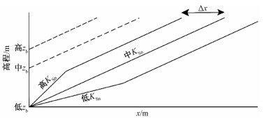
图 2 河道高程与chi(χ)值的线性关系(据Whipple et al., 2017修改)
在设定不同流域的初始高程zb相同的情况下, 分水岭两侧χ值的差异主要受河道陡峭程度的影响, 标准河道陡峭指数Ksn大的一侧所对应的χ值较小, 标准河道陡峭指数Ksn较小的一侧所对应的χ值较大
Figure 2. Linear relationship between the channel height and chi (χ) value (modified after Whipple et al., 2017)
Under the same initial elevation zb of different watershed, the difference of χ values on both sides of watershed is mainly affected by channel steepness. The side with higher standard channel steepness index Ksn corresponds to a smaller χ value, while the side with lower standard channel steepness index Ksn corresponds to a larger χ value

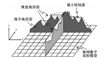
图 3 沉积面恢复示意图(据张会平等, 2006修改)
虚线代表未发生侵蚀之前的地形面(恢复地形面), 与现今地形面做差值运算可得侵蚀量的大小
Figure 3. Schematic diagram showing the resteration of the sedimentary surface (modified after Zhang et al., 2006)
The dashed line represents the topographic surface before erosion (restoring the topographic surface), and the amount of erosion can be obtained by difference calculation with the current topographic surface

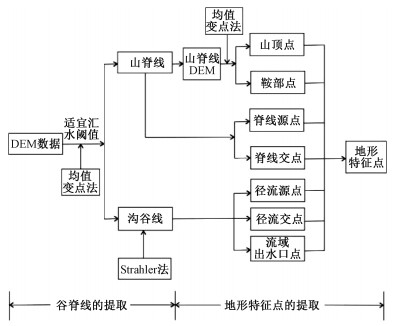
图 4 地形特征点和地形特征线提取示意图
Figure 4. Schematic diagram showing the extraction of terrain feature points and lines
表 1 全球数字高程(DEM)产品及其主要参数
Table 1. Global digital elevation products and the main parameters
DEM产品 发布时间/年 分辨率/m 覆盖范围 水平基准 垂直基准 数据来源 获取地址 ETOPO1 2008 30 90°S~90°N WGS84 MSL 数据融合 URL1 GTOPO30 1996 1000 90°S~90°N WGS84 MSL 数据融合 URL2 SRTM v1:2003
v2:2006
v3:201330
90 100056°S~60°N WGS84 EGM96 InSAR v1/v2:URL3
v3:URL4GMTED2010 2010 225
450 9090°S~84°N WGS84 EGM96 数据融合 URL2 ASTER GDEM v1:2009
v2:2011
v3:201930 83°S~83°N WGS84 EGM96 光学立体摄影测量 v2:URL5
v3:URL6AW3D30 v1:2016
v2:2017
v3:2018
v4:201930/12.5 82°S~82°N CRS80 EGM96 光学立体摄影测量 URL7 TanDEM-X DEM 2016 90 90°S~90°N WGS84-G1150 LE90 In SAR URL8 注: MSL—平均海平面、EMG96—1996地球引力模型、LE90—90%线概率误差
URL1: http://maps.ngdc.noaa.gov/viewers/wcs-client/
URL2: http://earthexplorer.usgs.gov/
URL3: http://dds.cr.usgs.gov/srtm/或http://www2.jpl.nasa.gov/srtm/
URL4: https://search.earthdata.nasa.gov/search?q=C1000000240-LPDAAC_ECS或https://lpdaac.usgs.gov/products/srtmgl1v003/
URL5: http://reverb.echo.nasa.gov/reverb/#utf8=%E2%9C%93&spatial_map=satellite&spatial_type=rectangle
URL6: https://search.earthdata.nasa.gov/search/granules?p=C1575726572-LPDAAC_ECS&fi=ASTER
URL7: https://www.eorc.jaxa.jp/ALOS/en/aw3d30/data/index.htm, URL8:https://download.geoservice.dlr.de/TDM90/files/ 下载: 导出CSV
表 2 常见的地形因子及其算法
Table 2. Common terrain factors and their algorithms
地形因子 算法 描述 坡度(slope) $ { slope }=arctan \sqrt{f_{x}^{2}+f_{y}^{2}}$ fx、fy分别代表x和y方向上的高程变化率。坡度即水平面与地形面之间的夹角, 可以描述地表的倾斜程度 坡向(aspect) $ { aspect }=180^{\circ}-arctan \frac{f_{x}}{f_{y}}+90^{\circ}\left|\frac{f_{y}}{f_{y}}\right|$ 坡向即地面一点的切平面的法线在水平面的投影与过该点的正北方向的夹角, 表征该点高程值改变量的最大变化方向 剖面曲率(Kv) $K_{\mathrm{v}}=\frac{p^{2} r+2 p q s+q^{2} t}{\left(p^{2}+q^{2}\right) \sqrt{1+p^{2}+q^{2}}}$ P为x方向的高程变化率, q为y方向的高程变化率, r为x方向上高程变化率的变化率, s为x方向高程变化率在y方向上的变化率, t为y方向高程变化率的变化率。剖面曲率是对地面坡度沿最大坡降方向地面高程变化率的度量 平面曲率(Kn) $K_{\mathrm{n}}=\frac{q^{2} r+2 p q s+p^{2} t}{\left(p^{2}+q^{2}\right) \sqrt{1+p^{2}+q^{2}}}$ 平面曲率可以描述地表曲面沿水平方向的弯曲变化情况 地形起伏度(RFi) $R F_{\mathrm{i}}=H_{\max }-H_{\min }$ Hmax、Hmin分别指某一固定分析窗口内的最大高程和最小高程。地形起伏度可反映水土流失区域的土壤侵蚀特征 地形粗糙度(R) $R=\frac{S_{\text {曲面 }}}{S_{\text {水平 }}}$ S曲面、S水平分别指某一地表单元的曲面面积与其在水平面上的投影面积。地形粗糙度可衡量地表的侵蚀程度 地表切割深度(Di) $D_{\mathrm{i}}=H_{\text {mean }}-H_{\min }$ Hmean、Hmin分别指某一固定分析窗口内的平均高程和最低高程。地表切割深度是反映地形起伏变化情况的指标 高程变异系数(V) $V=\frac{H_{\mathrm{std}}}{H_{\text {mean }}}$ Hstd、Hmean分别指某一固定分析窗口内的高程标准差与平均高程。高程变异系数对于区域内部的侵蚀切割情况和地形起伏有很好的反映 注: 公式中涉及相同的参数不做重复介绍, x、y为坐标系参数
Note: the formula involves the same parameters will not be repeated, x and y are in the xyz coordinate system.
下载: 导出CSV
-
ARDIANSYAH P O D, YOKOYAMA R, 2002. DEM generation method from contour lines based on the steepest slope segment chain and a monotone interpolation function[J]. ISPRS Journal of Photogrammetry and Remote Sensing, 57(1-2): 86-101. doi: 10.1016/S0924-2716(02)00117-X BERNATEK-JAKIEL A, JAKIEL M, 2021. Identification of soil piping-related depressions using an airborne LiDAR DEM: Role of land use changes[J]. Geomorphology, 378: 107591. doi: 10.1016/j.geomorph.2020.107591 CALVET M, GUNNELL Y, BRAUCHER R, et al., 2015. Cave levels as proxies for measuring post-orogenic uplift: Evidence from cosmogenic dating of alluvium-filled caves in the French Pyrenees[J]. Geomorphology, 246: 617-633. doi: 10.1016/j.geomorph.2015.07.013 CASTILLO M, FERRARI L, MUÑOZ-SALINAS E, 2017. Knickpoint retreat and landscape evolution of the Amatlán de Cañas half-graben (northern sector of Jalisco Block, western Mexico)[J]. Journal of South American Earth Sciences, 77: 108-122. doi: 10.1016/j.jsames.2017.05.003 CHANG Y C, SONG G S, HSU S K, 1998. Automatic extraction of ridge and valley axes using the profile recognition and polygon-breaking algorithm[J]. Computers & Geosciences, 24 (1): 83-93. http://howardzzh.com/research/terrain/PPA/doc/1998.CG.AutomaticExtraction.pdf CHEN C F, LIU F Y, YAN C Q, et al., 2016. A Huber-derived robust multi-quadric interpolation method for DEM construction[J]. Geomatics and Information Science of Wuhan University, 41(6): 803-809. (in Chinese with English abstract) http://www.researchgate.net/publication/305159401_A_huber-derived_robust_multi-quadric_interpolation_method_for_DEM_construction CHENG L, WU D Y, JIN W, et al., 2017. Geomorphic evolution of the Qiantang River drainage basin based on the analysis of topographic indexs[J]. Quaternary Sciences, 37 (2): 343-352. ]. CHEN X Y, 2020. Research on lithology classification based on terrain factors[D]. Changchun: Jilin University. (in Chinese with English abstract) CHENG W M, ZHOU C H, CHAI H X, et al., 2009. Quantitative extraction and analysis of basic morphological types of land geomorphology in China[J]. Journal of Geo-Information Science, 11 (6): 725-736. (in Chinese with English abstract) http://www.researchgate.net/publication/250262115_Quantitative_Extraction_and_Analysis_of_Basic_Morphological_Types_of_Land_Geomorphology_in_China_Quantitative_Extraction_and_Analysis_of_Basic_Morphological_Types_of_Land_Geomorphology_in_China CLARK M K, ROYDEN L H, WHIPPLE K X, et al., 2006. Use of a regional, relict landscape to measure vertical deformation of the eastern Tibetan Plateau[J]. Journal of Geophysical Research: Earth Surface, 111 (F3): F03002. http://deepblue.lib.umich.edu/bitstream/2027.42/96342/1/jgrf155.pdf CLARK M K, SCHOENBOHM L M, ROYDEN L H, et al., 2004. Surface uplift, tectonics, and erosion of eastern Tibet from large-scale drainage patterns[J]. Tectonics, 23 (1): TC1006. http://www.onacademic.com/detail/journal_1000035770625710_173a.html DENG Y X, WILSON J P, SHENG J, 2006. Effects of variable attribute weights on landform classification[J]. Earth Surface Processes and Landforms, 31 (11): 1452-1462. doi: 10.1002/esp.1401 DIBIASE R A, WHIPPLE K X, HEIMSATH A M, et al., 2010. Landscape form and millennial erosion rates in the San Gabriel Mountains, CA[J]. Earth and Planetary Science Letters, 289 (1-2): 134-144. doi: 10.1016/j.epsl.2009.10.036 EHSANI A H, QUIEL F, MALEKIAN A, 2010. Effect of SRTM resolution on morphometric feature identification using neural network-self organizing map[J]. GeoInformatica, 14 (4): 405-424. doi: 10.1007/s10707-009-0085-4 EJARQUE A, BEAUGER A, MIRAS Y, et al., 2015. Historical fluvial palaeodynamics and multi-proxy palaeoenvironmental analyses of a palaeochannel, Allier River, France[J]. Geodinamica acta, 27 (1): 25-47. doi: 10.1080/09853111.2013.877232 FAN J R, ZHANG Z Y, LI L H, 2015. Mountain demarcation and mountainous area divisions of Sichuan province[J]. Geographical Research, 34 (1): 65-73. (in Chinese with English abstract) http://en.cnki.com.cn/Article_en/CJFDTOTAL-DLYJ201501007.htm FLORINSKY I V, 2009. Computation of the third-order partial derivatives from a digital elevation model[J]. International journal of geographical information science, 23 (2): 213-231. doi: 10.1080/13658810802527499 FOX M, BODIN T, SHUSTER D L, 2015. Abrupt changes in the rate of Andean Plateau uplift from reversible jump Markov Chain Monte Carlo inversion of river profiles[J]. Geomorphology, 238: 1-14. doi: 10.1016/j.geomorph.2015.02.022 GAO Z Y, XIE Y L, WANG N L, et al., 2019. Response of three global DEM data accuracy to different terrain factors in Qinghai-Tibet Plateau[J]. Bulletin of Soil and water conservation, 39 (2): 184-191. (in Chinese with English abstract) http://en.cnki.com.cn/Article_en/CJFDTotal-STTB201902030.htm GU W Y, MENG X R, ZHU X C, et al., 2020. Geomorphological classification research based on BEMD decomposition[J]. Journal of Geo-Information Science, 22 (3): 464-473. (in Chinese with English abstract) GURU D S, SHEKAR B H, NAGABHUSHAN P., 2004. A simple and robust line detection algorithm based on small eigenvalue analysis[J]. Pattern Recognition Letters, 25 (1): 1-13. doi: 10.1016/j.patrec.2003.08.007 HAREL M A, MUDD S M, ATTAL M, 2016. Global analysis of the stream power law parameters based on worldwide 10Be denudation rates[J]. Geomorphology, 268: 184-196. doi: 10.1016/j.geomorph.2016.05.035 HETZEL R, 2013. Active faulting, mountain growth, and erosion at the margins of the Tibetan Plateau constrained by in situ-produced cosmogenic nuclides[J]. Tectonophysics, 582: 1-24. doi: 10.1016/j.tecto.2012.10.027 HU J L, TANG M G, LUO M L, et al., 2020. The extraction of characteristic elements of mountain based on DEM[J]. Journal of Geo-Information Science, 22 (3): 422-430. (in Chinese with English abstract) HU Z, NIE Y Y, 2015. DEM-based landform taxonomic features of Hunan Province[J]. Geography and Geo-Information Science, 31 (6): 67-71. (in Chinese with English abstract) http://en.cnki.com.cn/Article_en/CJFDTOTAL-DLGT201506013.htm HUANG F M, YANG J B, ZHANG B, et al., 2020. Regional Terrain Complexity Assessment Based on Principal Component Analysis and Geographic Information System: A Case of Jiangxi Province, China[J]. ISPRS International Journal of Geo-Information, 9 (9): 539. doi: 10.3390/ijgi9090539 HUANG Y F, LI Z H, NING H, et al., 2019. Research on Rock and Mineral Information Extraction Based on ASTER Remote Sensing Image[J]. Spacecraft Engineering 28 (6): 130-135. (in Chinese with English abstract) http://en.cnki.com.cn/Article_en/CJFDTotal-HTGC201906021.htm KANG X, WANG Y W, QIN C Z, et al., 2016. A new method of landform element classification based on multi-scale morphology[J]. Geographical Research, 35 (9): 1637-1646. (in Chinese with English abstract) KIRBY E, WHIPPLE K X, 2012. Expression of active tectonics in erosional landscapes[J]. Journal of structural geology, 44: 54-75. doi: 10.1016/j.jsg.2012.07.009 LAGUE D, HOVIUS N, DAVY P, 2005. Discharge, discharge variability, and the bedrock channel profile[J]. Journal of Geophysical Research: Earth Surface, 110 (F4): F04006. http://hal.archives-ouvertes.fr/hal-00069334/document LAKSHMI S E, YARRAKULA K, 2018. Review and critical analysis on digital elevation models[J]. Geofizika, 35 (2): 129-157. LANG K A, HUNTINGTON K W, BURMESTER R F, et al., 2016. Rapid exhumation of the eastern Himalayan syntaxis since the late Miocene[J]. GSA Bulletin, 128 (9-10): 1403-1422. doi: 10.1130/B31419.1 LEASE R O, EHLERS T A, 2013. Incision into the Eastern Andean Plateau During Pliocene Cooling[J]. Science, 341 (6147): 774-776. doi: 10.1126/science.1239132 LI B, ZHANG J, YUE Z Y, et al., 2020. Deriving terrain factors from high-resolution lunar images: A case study of the Mons Rümker Region[J]. Geomorphology, 358: 107114. doi: 10.1016/j.geomorph.2020.107114 LI H, HUANG X Y, DENG Q L, et al., 2012. Mapping of planation surfaces in the southwest region of Hubei Province, China-Using the DEM-derived painted relief model[J]. Journal of Earth Science, 23 (5): 719-730. doi: 10.1007/s12583-012-0290-1 LI J J, FANG X M, PAN B T, et al., 2001. Late Cenozoic intensive uplift of Qinghai-Xizang Plateau and its impacts on environments in surrounding area[J]. Quaternary Sciences, 21 (5): 381-391. (in Chinese with English abstract) http://www.researchgate.net/publication/284098400_Late_Cenozoic_intensive_uplift_of_Qinghai-Xizang_Plateau_and_its_impacts_on_environments_in_surrounding_area LI J J, MA Z H, LI X M, et al., 2017. Late Miocene-Pliocene geomorphological evolution of the Xiaoshuizi peneplain in the Maxian Mountains and its tectonic significance for the northeastern Tibetan Plateau[J]. Geomorphology, 295: 393-405. doi: 10.1016/j.geomorph.2017.07.024 LIN L L, LI X M, ZHANG H P, et al., 2021. River capture and divide migration of the Zhuozishan area in the northwestern margin of the Ordos Block[J]. Journal of Geomechanics, 27 (2): 294-303. (in Chinese with English abstract) LIU J, ZHANG J Y, GE Y K, et al., 2018. Tectonic Geomorphology: an interdisciplinary study of the interaction among tectonic climatic and surface processes[J]. Chinese Science Bulletin, 63 (30): 3070-3088. (in Chinese with English abstract) doi: 10.1360/N972018-00498 LIU L, ZHANG D, YOU J, 2007. Detecting Wide Lines Using Isotropic Nonlinear Filtering[J]. IEEE Transactions on Image Processing, 16 (6): 1584-1595. doi: 10.1109/TIP.2007.894288 LIU S F, WANG T, ZHANG H P, et al., 2005. Application of digital elevation model to surficial process research[J]. Earth Science Frontiers, 12(1): 303-309. (in Chinese with English abstract) LIU X, WANG L, GAO P L, 2011. Extraction of stream runoff nodes based on geometric network[J]. Science of Surveying and Mapping, 36 (5): 85-86, 72. (in Chinese with English abstract) http://en.cnki.com.cn/Article_en/CJFDTOTAL-CHKD201105030.htm LIU Y, WANG Y X, PAN B T, 1999. A preliminary approach on the 3D presentation and quantitative analysis of planation surface[J]. Geographical Research, 18(4): 391-399. (in Chinese with English abstract) http://en.cnki.com.cn/Article_en/CJFDTOTAL-DLYJ199904008.htm LIU Y X, 2014. The research and implementation n the skeleton feature extraction method for terrain model based on profile recognition and morphological simplification[D]. Changchun: Northeast Normal University. (in Chinese with English abstract) LUCIEER A, TURNER D, KING D H, et al., 2014. Using an Unmanned Aerial Vehicle (UAV) to capture micro-topography of Antarctic moss beds[J]. International Journal of Applied Earth Observation and Geoinformation, 27: 53-62. doi: 10.1016/j.jag.2013.05.011 LUO W, LIU C C, 2018. Innovative landslide susceptibility mapping supported by geomorphon and geographical detector methods[J]. Landslides, 15 (3): 465-474. doi: 10.1007/s10346-017-0893-9 MA J P, 2017. Quantitative study geomorphic indices and planation surfaces of the Taohe drainage system based on DEM[D]. Lanzhou: Lanzhou University. (in Chinese with English abstract) MA Z H, LI X M, PENG T J, et al., 2020. Landscape evolution of the Dabanshan planation surface: Implications for the uplift of the eastern tip of the Qilian Mountains since the Late Miocene[J]. Geomorphology, 356: 107091. doi: 10.1016/j.geomorph.2020.107091 NOH M J, HOWAT I M, 2015. Automated stereo-photogrammetric DEM generation at high latitudes: Surface Extraction with TIN-based Search-space Minimization (SETSM) validation and demonstration over glaciated regions[J]. GIScience & remote sensing, 52 (2): 198-217. doi: 10.1080/15481603.2015.1008621 POLIDORI L, EL HAGE M, 2020. Digital Elevation Model Quality Assessment Methods: A Critical Review[J]. Remote sensing, 12 (21): 3522. doi: 10.3390/rs12213522 PU Y, LUO M L, LIU W M, et al., 2018. Research on the correlation characteristics of peak points based on DEM: a case study of the main peak area of Huaying mountain of folded mountain system in East Sichuan[J]. Geography and GEO-information Science, 34 (4): 96-100. (in Chinese with English abstract) http://en.cnki.com.cn/Article_en/CJFDTOTAL-DLGT201804015.htm QUYE-SAWYER J, WHITTAKER A C, ROBERTS G G, 2020. Calibrating fluvial erosion laws and quantifying river response to faulting in Sardinia, Italy[J]. Geomorphology, 370: 107388. doi: 10.1016/j.geomorph.2020.107388 REN J S, NIU B G, ZHAO L, et al., 2019. Basic ideas of the multisphere tectonics of earth system[J]. Journal of Geomechanics, 25 (5): 607-612. (in Chinese with English abstract) ROOD D H, BURBANK D W, FINKEL R C, 2011. Chronology of glaciations in the Sierra Nevada, California, from 10Be surface exposure dating[J]. Quaternary Science Reviews, 30 (5-6): 646-661. doi: 10.1016/j.quascirev.2010.12.001 SCHOENBOHM L M, BURCHFIEL B C, CHEN L, et al., 2005. Exhumation of the Ailao Shan shear zone recorded by Cenozoic sedimentary rocks, Yunnan Province, China[J]. Tectonics, 24 (6): TC6015. http://ibrarian.net/navon/paper/Exhumation_of_the_Ailao_Shan_shear_zone_recorded_.pdf?paperid=5203903 SCOWN M W, THOMS M C, DE JAGER N R, 2015. Floodplain complexity and surface metrics: Influences of scale and geomorphology[J]. Geomorphology, 245: 102-116. doi: 10.1016/j.geomorph.2015.05.024 ŚLEDŹ S, EWERTOWSKI M W, PIEKARCZYK J, 2021. Applications of unmanned aerial vehicle (UAV) surveys and Structure from Motion photogrammetry in glacial and periglacial geomorphology[J]. Geomorphology, 378: 107620. doi: 10.1016/j.geomorph.2021.107620 SOFIA G, 2020. Combining geomorphometry, feature extraction techniques and Earth-surface processes research: The way forward[J]. Geomorphology, 355: 107055. doi: 10.1016/j.geomorph.2020.107055 STEER P, HUISMANS R S, VALLA P G, et al., 2012. Bimodal Plio-Quaternary glacial erosion of fjords and low-relief surfaces in Scandinavia[J]. Nature Geoscience, 5 (9): 635-639. doi: 10.1038/ngeo1549 SUN C L, WANG J L, 2008. The progress on automatic basin streamline extracting & classifying methods based on DEM[J]. Progress in Geography, 27(1): 118-124. (in Chinese with English abstract) http://en.cnki.com.cn/Article_en/CJFDTOTAL-DLKJ200801018.htm TANG G A, 2014. Progress of DEM and digital terrain analysis in China[J]. Acta Geographica Sinica, 69 (9): 1305-1325. (in Chinese with English abstract) TANG G A, LI F Y, XIONG L Y, 2017a. Progress of Digital Terrain Analysis in the Loess Plateau of China[J]. Geography and Geo-Information Science, 33 (4): 1-7. (in Chinese with English abstract) http://en.cnki.com.cn/Article_en/CJFDTOTAL-DLGT201704001.htm TANG G A, NA J M, CHENG W M, 2017b. Progress of digital terrain analysis on regional geomorphology in China[J]. Acta Geodaetica et CartographicaSinica, 46 (10): 1570-1591. (in Chinese with English abstract) TANG X M, LI S J, LI T, et al., 2021. Review on global digital elevation products[J]. Journal of Remote Sensing, 25 (1): 167-181. (in Chinese with English abstract) TU X J, CHEN X H, 2010. Characteristics variability study of regional river runoff time series based on change point recognition[J]. Journal of Natural Resources 25 (11): 1930-1937. (in Chinese with English abstract) http://www.cqvip.com/QK/96143X/201011/36056825.html VALENTINE A, KALNINS L, 2016. An introduction to learning algorithms and potential applications in geomorphometry and Earth surface dynamics[J]. Earth Surface Dynamics, 4 (2): 445-460. doi: 10.5194/esurf-4-445-2016 VAYSSIōRE A, CASTANET C, GAUTIER E, et al., 2020. Readjustments of a sinuous river during the last 6000 years in northwestern Europe (Cher River, France): from an active meandering river to a stable river course under human forcing[J]. Geomorphology, 370: 107395. doi: 10.1016/j.geomorph.2020.107395 WANG J Y, CUI T J, MIAO G Q, 2004. Digital elevation model and its data structure[J]. Hydrographic Surveying and Charting, 24 (3): 1-4. (in Chinese with English abstract) http://en.cnki.com.cn/Article_en/CJFDTOTAL-HYCH200403001.htm WANG Y G, ZHU C Q WANG Z W, 2008. A surface model of grid DEM based on coons surface[J]. Acta Geodaetica et Cartographica Sinica 37 (2): 217-222. (in Chinese with English abstract) http://en.cnki.com.cn/Article_en/CJFDTOTAL-CHXB200802017.htm WANG Y W, QIN C Z, 2017. Review of methods for landform automatic classification[J]. Geography and Geo-Information Science, 33 (4): 16-21. (in Chinese with English abstract) http://en.cnki.com.cn/Article_en/CJFDTOTAL-DLGT201704003.htm WANG Y Z, ZHANG H P, ZHENG D W, et al., 2017. How a stationary knickpoint is sustained: New insights into the formation of the deep YarlungTsangpo Gorge[J]. Geomorphology, 285: 28-43. doi: 10.1016/j.geomorph.2017.02.005 WANG Y Z, ZHENG D W, ZHANG H P, et al., 2019. The distribution of active rock uplift in the interior of the western Qilian Shan, NE Tibetan Plateau: Inference from bedrock channel profiles[J]. Tectonophysics, 759: 15-29. doi: 10.1016/j.tecto.2019.04.001 WANG Y Z, ZHENG D W, ZHANG H P, et al., 2020. Activity Characteristics of the Huashan Piedmont Normal Fault: Insights from Fluvial Geomorphic Parameters[J]. Seismology and Geology 42 (2): 382-398. (in Chinese with English abstract) WHIPPLE K X, 2004. Bedrock Rivers and the Geomorphology of Active Orogens[J]. Annual Review of Earth and Planetary Sciences, 32: 151-185. doi: 10.1146/annurev.earth.32.101802.120356 WHIPPLE K X, FORTE A M, DIBIASE R A, et al., 2017. Timescales of landscape response to divide migration and drainage capture: Implications for the role of divide mobility in landscape evolution[J]. Journal of Geophysical Research: Earth Surface, 122 (1): 248-273. doi: 10.1002/2016JF003973 WILLETT S D, MCCOY S W, PERRON J T, et al., 2014. Dynamic Reorganization of River Basins[J]. Science, 343 (6175): 1248765. doi: 10.1126/science.1248765 WILSON J P, 2018. Geomorphometry: Today and tomorrow[J]. Peer J Preprints 6: e27197v1. WU Q J, CHEN Y M, ZHOU H Y, et al., 2020. A New Algorithm for Calculating the Flow Path Curvature (C) from the Square-Grid Digital Elevation Model (DEM)[J]. ISPRS International Journal of Geo-Information, 9 (9): 510. doi: 10.3390/ijgi9090510 XIA S, RUAN R Z, SHE Y J, et al., 2012. Classification of remote sensing image based on C4.5 algorithm[J]. Geospatial Information, 10 (4): 89-91, 94. (in Chinese with English abstract) XIAO Z, FUJI N, IIDAKA T, et al., 2020. Seismic structure beneath the Tibetan Plateau from iterative finite-frequency tomography based on ChinArray: New insights into the Indo-Asian collision[J]. Journal of Geophysical Research: Solid Earth, 125(2): e2019JB018344. doi: 10.1029/2019JB018344 XIE Y Q, ZHU H C, TANG G A, et al., 2013. Extraction and analysis of gully feature points based on DEM[J]. Journal of Geo-Information Science, 15 (1): 61-67. (in Chinese with English abstract) doi: 10.3724/SP.J.1047.2013.00061 XIN X, 2018. The study on the mapping and hazard assessment of shallow landslides in gully loess area[D]. Lanzhou: Lanzhou University. (in Chinese with English abstract) XIONG L Y, TANG G A, YANG X, et al., 2021. Geomorphology-oriented digital terrain analysis: Progress and perspectives[J]. Acta Geographica Sinica, 76 (3): 595-611. (in Chinese with English abstract) XU L, LI J H, LIU C H, et al., 2017. Research on Geomorphological Morphology and Regionalization of Hoh Xil Based on Digital Elevation Model (DEM)[J]. Acta ScientiarumNaturalium Universitatis Pekinensis, 53 (5): 833-842. (in Chinese with English abstract) YANG R, WILLETT S D, GOREN L, 2015. In situ low-relief landscape formation as a result of river network disruption[J]. Nature, 520 (7548): 526-529. doi: 10.1038/nature14354 YANG X, TANG G A, XIAO C C, et al., 2011. The scaling method of specific catchment area from DEMs[J]. Journal of Geographical Sciences, 21 (4): 689-704. doi: 10.1007/s11442-011-0873-2 YAO H J, BEGHEIN C, VAN DER HILST R D, 2008. Surface wave array tomography in SE Tibet from ambient seismic noise and two station analysis II. Crustal and upper-mantle structure[J]. Geophysical Journal International, 173 (1): 205-219. doi: 10.1111/j.1365-246X.2007.03696.x ZAIDI S M, AKBARI A, GISEN J I, et al., 2018. Utilization of Satellite-based Digital Elevation Model (DEM) for Hydrologic Applications: A Review[J]. Journal of the Geological Society of India, 92 (3): 329-336. doi: 10.1007/s12594-018-1016-5 ZEITLER P K, 2001. Erosion, Himalayan Geodynamics, and the Geomorphology of Metamorphism[J]. GSA Today, 11 (1): 4-94. doi: 10.1130/1052-5173(2001)011<0004:EHGATG>2.0.CO;2 ZHANG H P, 2006. Study on late Cenozoic geomorphic processes of typical regions along the eastern and northeastern Tibetan margins[D]. Beijing: China University of Geosciences(Beijing). (in Chinese with English abstract) ZHANG H P, CRADDOCK W H, LEASE R O, et al., 2012. Magnetostratigraphy of the Neogene Chaka basin and its implications for mountain building processes in the north-eastern Tibetan Plateau[J]. Basin Research, 24 (1): 31-50. doi: 10.1111/j.1365-2117.2011.00512.x ZHANG H P, KIRBY E, PITLICK J, et al., 2017. Characterizing the transient geomorphic response to base-level fall in the northeastern Tibetan Plateau[J]. Journal of Geophysical Research: Earth Surface, 122 (2): 546-572. doi: 10.1002/2015JF003715 ZHANG H Q, LIU X Y, YANG S, et al., 2017. Retrieval of remote sensing images based on semisupervised deep learning[J]. Journal of Remote Sensing, 21 (3): 406-414. (in Chinese with English abstract) http://en.cnki.com.cn/Article_en/CJFDTOTAL-YGXB201703008.htm ZHAO W F, XIONG L Y, DING H, et al., 2017. Automatic recognition of loess landforms using Random Forest method[J]. Journal of Mountain Science, 14 (5): 885-897. doi: 10.1007/s11629-016-4320-9 ZHU H C, ZHAO Y P, XU Y X, et al., 2018. Hierarchy structure characteristics analysis for the China Loess watersheds based on gully node calibration[J]. Journal of Mountain Science, 15 (12): 2637-2650. doi: 10.1007/s11629-018-5000-8 ZUFFETTI C, BERSEZIO R, 2020. Morphostructural evidence of Late Quaternary tectonics at the Po Plain-Northern Apennines border (Lombardy, Italy)[J]. Geomorphology, 364: 107245. doi: 10.1016/j.geomorph.2020.107245 ZUZA A V, YIN A, 2016. Continental deformation accommodated by non-rigid passive bookshelf faulting: An example from the Cenozoic tectonic development of northern Tibet[J]. Tectonophysics, 677-678: 227-240. doi: 10.1016/j.tecto.2016.04.007 陈传法, 刘凤英, 闫长青, 等, 2016. DEM建模的多面函数Huber抗差算法[J]. 武汉大学学报(信息科学版), 41 (6): 803-809. https://www.cnki.com.cn/Article/CJFDTOTAL-WHCH201606014.htm 程璐, 武登云, 靳文, 等, 2017. 基于地貌计量指标分析的钱塘江流域地貌演化特征[J]. 第四纪研究, 37 (2): 343-352. 陈霄燕, 2020. 基于地形因子的岩性分类方法研究[D]. 长春: 吉林大学. 程维明, 周成虎, 柴慧霞, 等, 2009. 中国陆地地貌基本形态类型定量提取与分析[J]. 地球信息科学学报, 11 (6): 725-736. doi: 10.3969/j.issn.1560-8999.2009.06.007 范建容, 张子瑜, 李立华, 2015. 四川省山地类型界定与山区类型划分[J]. 地理研究, 34 (1): 65-73. doi: 10.3969/j.issn.1003-2363.2015.01.012 高志远, 谢元礼, 王宁练, 等, 2019. 青藏高原地区3种全球DEM精度对不同地形因子的响应[J]. 水土保持通报, 39 (2): 184-191. https://www.cnki.com.cn/Article/CJFDTOTAL-STTB201902030.htm 顾文亚, 孟祥瑞, 朱晓晨, 等, 2020. 基于BEMD分解的地貌分类研究[J]. 地球信息科学学报, 22 (3): 464-473. https://www.cnki.com.cn/Article/CJFDTOTAL-DQXX202003015.htm 胡金龙, 唐梦鸽, 罗明良, 等, 2020. 基于DEM的一体化山地特征要素提取[J]. 地球信息科学学报, 22 (3): 422-430. https://www.cnki.com.cn/Article/CJFDTOTAL-DQXX202003011.htm 胡最, 聂阳意, 2015. 基于DEM的湖南省地貌形态特征分类[J]. 地理与地理信息科学, 31 (6): 67-71. doi: 10.3969/j.issn.1672-0504.2015.06.013 黄宇飞, 李智慧, 宁慧, 等, 2019. 应用ASTER遥感图像的岩矿信息提取研究[J]. 航天器工程, 28 (6): 130-135. https://www.cnki.com.cn/Article/CJFDTOTAL-HTGC201906021.htm 康鑫, 王彦文, 秦承志, 等, 2016. 多分析尺度下综合判别的地形元素分类方法[J]. 地理研究, 35 (9): 1637-1646. https://www.cnki.com.cn/Article/CJFDTOTAL-DLYJ201609005.htm 李吉均, 方小敏, 潘保田, 等, 2001. 新生代晚期青藏高原强烈隆起及其对周边环境的影响[J]. 第四纪研究, (5): 381. doi: 10.3321/j.issn:1001-7410.2001.05.001 林玲玲, 李雪梅, 张会平, 等, 2021. 鄂尔多斯西北缘桌子山地区河流袭夺和分水岭迁移研究[J]. 地质力学学报, 27(2): 294-303. https://journal.geomech.ac.cn/ch/reader/view_abstract.aspx?flag=1&file_no=20210212&journal_id=dzlxxb 刘静, 张金玉, 葛玉魁, 等, 2018. 构造地貌学: 构造-气候-地表过程相互作用的交叉研究[J]. 科学通报, 63 (30): 3070-3088. https://www.cnki.com.cn/Article/CJFDTOTAL-KXTB201830003.htm 刘少峰, 王陶, 张会平, 等, 2005. 数字高程模型在地表过程研究中的应用[J]. 地学前缘, 12(1): 303-309. doi: 10.3321/j.issn:1005-2321.2005.01.040 刘晓, 王雷, 高佩玲, 2011. 利用几何网络提取河网径流节点的方法研究[J]. 测绘科学, 36 (5): 85-86, 72. https://www.cnki.com.cn/Article/CJFDTOTAL-CHKD201105030.htm 刘亚鑫, 2014. 基于剖面识别和形态简化的地形骨架特征提取方法研究与实现[D]. 长春: 东北师范大学. 刘勇, 王义祥, 潘保田, 1999. 夷平面的三维显示与定量分析方法初探[J]. 地理研究, 18(4): 391-399. doi: 10.3321/j.issn:1000-0585.1999.04.008 马金萍, 2017. 基于DEM的洮河流域水系地貌参数与夷平面定量化研究[D]. 兰州: 兰州大学. 蒲阳, 罗明良, 刘维明, 等, 2018. 基于DEM的山顶点关联特征研究: 以川东褶皱山系华蓥山主峰区为例[J]. 地理与地理信息科学, 34 (4): 96-100. doi: 10.3969/j.issn.1672-0504.2018.04.015 任纪舜, 牛宝贵, 赵磊, 等, 2019. 地球系统多圈层构造观的基本内涵[J]. 地质力学学报, 25 (5): 607-612. https://journal.geomech.ac.cn/ch/reader/view_abstract.aspx?flag=1&file_no=20190502&journal_id=dzlxxb 孙崇亮, 王卷乐, 2008. 基于DEM的水系自动提取与分级研究进展[J]. 地理科学进展, 27(1): 118-124. https://www.cnki.com.cn/Article/CJFDTOTAL-DLKJ200801018.htm 汤国安, 2014. 我国数字高程模型与数字地形分析研究进展[J]. 地理学报, 69 (9): 1305-1325. https://www.cnki.com.cn/Article/CJFDTOTAL-DLXB201409007.htm 汤国安, 李发源, 熊礼阳, 2017a. 黄土高原数字地形分析研究进展[J]. 地理与地理信息科学, 33 (4): 1-7. https://www.cnki.com.cn/Article/CJFDTOTAL-DLGT201704001.htm 汤国安, 那嘉明, 程维明, 2017b. 我国区域地貌数字地形分析研究进展[J]. 测绘学报, 46 (10): 1570-1591. https://www.cnki.com.cn/Article/CJFDTOTAL-CHXB201710040.htm 唐新明, 李世金, 李涛, 等, 2021. 全球数字高程产品概述[J]. 遥感学报, 25 (1): 167-181. https://www.cnki.com.cn/Article/CJFDTOTAL-YGXB202101011.htm 涂新军, 陈晓宏, 2010. 基于变点识别的区域河川径流量特征值变异研究[J]. 自然资源学报, 25 (11): 1930-1937. doi: 10.11849/zrzyxb.2010.11.012 王家耀, 崔铁军, 苗国强, 2004. 数字高程模型及其数据结构[J]. 海洋测绘, 24(3): 1-4. doi: 10.3969/j.issn.1671-3044.2004.03.001 王彦文, 秦承志, 2017. 地貌形态类型的自动分类方法综述[J]. 地理与地理信息科学, 33 (4): 16-21. doi: 10.3969/j.issn.1672-0504.2017.04.003 王耀革, 朱长青, 王志伟, 2008. 基于Coons曲面的规则格网DEM表面模型[J]. 测绘学报, 37 (2): 217-222. doi: 10.3321/j.issn:1001-1595.2008.02.016 王一舟, 郑德文, 张会平, 等, 2020. 华山山前正断层的分段活动特征: 来自河流地貌参数的约束[J]. 地震地质, 42 (2): 382-398. doi: 10.3969/j.issn.0253-4967.2020.02.009 夏双, 阮仁宗, 佘远见, 等, 2012. 基于C4.5算法的遥感影像分类[J]. 地理空间信息, 10 (4): 89-91, 94. https://www.cnki.com.cn/Article/CJFDTOTAL-DXKJ201204031.htm 谢轶群, 朱红春, 汤国安, 等, 2013. 基于DEM的沟谷特征点提取与分析[J]. 地球信息科学学报, 15 (1): 61-67. https://www.cnki.com.cn/Article/CJFDTOTAL-DQXX201301010.htm 辛星, 2018. 黄土沟壑区浅层滑坡的制图和危险性评价研究[D]. 兰州: 兰州大学. 熊礼阳, 汤国安, 杨昕, 等, 2021. 面向地貌学本源的数字地形分析研究进展与展望[J]. 地理学报, 76 (3): 595-611. https://www.cnki.com.cn/Article/CJFDTOTAL-DLXB202103009.htm 许丽, 李江海, 刘持恒, 等, 2017. 基于数字高程模型(DEM)的可可西里地貌及区划研究[J]. 北京大学学报(自然科学版), 53 (5): 833-842. https://www.cnki.com.cn/Article/CJFDTOTAL-BJDZ201705006.htm 张会平, 2006. 青藏高原东缘、东北缘典型地区晚新生代地貌过程研究[D]. 北京: 中国地质大学(北京). 张洪群, 刘雪莹, 杨森, 等, 2017. 深度学习的半监督遥感图像检索[J]. 遥感学报, 21 (3): 406-414. https://www.cnki.com.cn/Article/CJFDTOTAL-YGXB201703008.htm -

 下载:
下载:


计量
- 文章访问数: 1815
- HTML全文浏览量: 244
- PDF下载量: 200
- 被引次数: 0
