

RESEARCH ON RISK ASSESSMENT OF GEOLOGICAL HAZARDS IN QINLING-DABA MOUNTAIN AREA, SOUTH SHAANXI PROVINCE
-
摘要: 陕西省是中国地质灾害最严重的省份之一,而陕南秦巴山区地质灾害灾情尤为严峻,因此进行地质灾害危险性评价对指导防灾减灾工作意义重大。文章以陕南秦巴山区为研究区,基于GIS技术与2001-2016年研究区地质灾害灾情数据,分析研究了区内地质灾害与各指标因子之间的敏感性关系,并确定了高程、岩土体类型、断裂构造、降雨等7个影响地质灾害发生较大的因子作为区域地质灾害危险性评价指标。其次,以各指标条件下地质灾害数量和累计发生频次曲线斜率的突变为依据,对评价指标因子进行状态分级。最后,运用信息量法建立栅格数据模型展开区域地质灾害危险性评价。研究结果表明:高危险性、较高危险性、中危险性的地区占研究区总面积的百分比分别为10.52%、28.31%、30.19%,区内地质灾害点的空间分布与地质灾害危险性评价结果基本一致,信息量模型的预测精度为90.16%。文章将经验知识与数据驱动的分析方法相结合,应用于较大范围的地质灾害危险性区划,研究结果可为区域地质灾害防治工作提供参考依据。Abstract: Shaanxi Province is one of the provinces with the most serious geological disasters in China, especially the Qinling-Daba mountain area in south Shaanxi Province. Therefore, it is of great significance to conduct geological hazard assessment to guide disaster prevention and reduction. Taking Qinling-Daba mountain area as the study area, firstly based on GIS technology and the geological hazard data of the study area from 2001 to 2016, the sensitivity relationship between geological hazards and various index factors in the area is studied, and seven factors affecting the occurrence of geological hazards, such as elevation, type of rock and soil mass, fault structure and rainfall, are determined as the risk assessment indexes of regional geological hazards. Secondly, according to the number of geological disasters and the slope abrupt change of cumulative frequency curves under each index, the assessment index factors are graded into different states. Finally, the grid data model is established to carry out regional geological hazards assessment by using information value model. The results show that the percentages of high-risk, relatively high-risk, and medium-risk areas in the study area are 10.52%, 28.31% and 30.19%, respectively. The spatial distribution of geological hazards in the region is basically consistent with the hazard assessment results, and the prediction accuracy is 90.16%. This research combines empirical knowledge with data-driven analysis methods and applies to a wide range of geological hazard zoning. The conclusions provide reference for prevention and control of regional geological hazards.
-

图 3 地质灾害分布与高程的关系
Figure 3. The relationship between geological hazard distribution and elevation

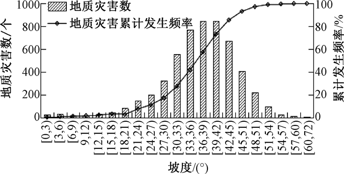
图 4 地质灾害分布与坡度的关系
Figure 4. The relationship between geological hazard distribution and slope

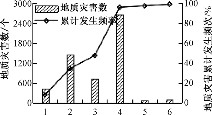
图 5 地质灾害分布与岩土体类型的关系
岩土类型:1——坚硬岩石;2——坚硬、半坚硬岩石;3——半坚硬、半软弱岩石;4——软弱岩石;5——粘性土;6——砂土、砾石层
Figure 5. The relationship between geological hazard distribution and the type of rock and soil

图 6 地质灾害分布与断裂缓冲区的关系
Figure 6. The relationship between geological hazard distribution and fault buffer

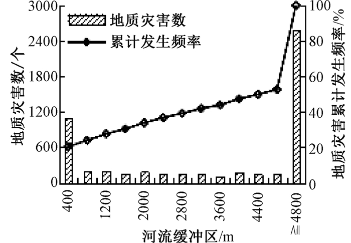
图 7 地质灾害分布与河流缓冲区的关系
Figure 7. The relationship between geological hazard distribution and river buffer

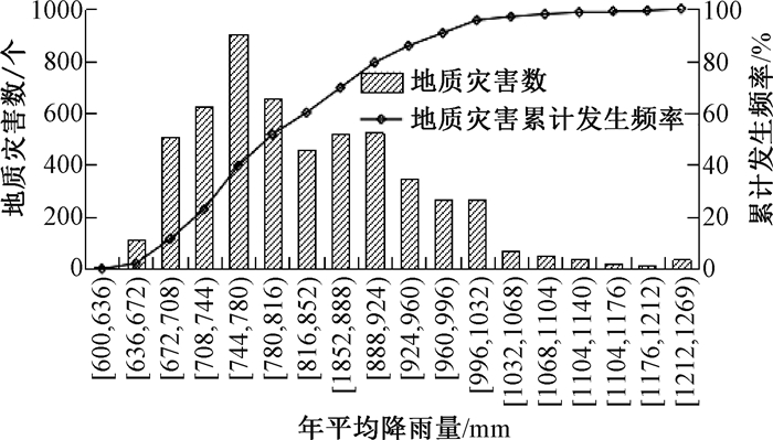
图 8 地质灾害分布与年平均降雨量的关系
Figure 8. The relationship between geological hazard distribution and average annual rainfall

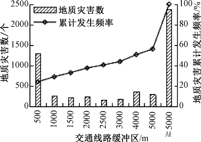
图 9 地质灾害分布与道路缓冲区的关系
Figure 9. The relationship between geological hazard distribution and road buffer

图 10 陕南秦巴山区各指标因子状态分级图
Figure 10. Grading chart of each index factor in Qinling-Daba mountain area
表 2 各指标因子间的相关关系
Table 2. The correlation between index factors
相关
关系指标
因子高程 坡度 岩性 断裂 水系 地震 降雨 人类
活动R 高程 1 坡度 0.04 1 岩性 0.07 -0.01 1 断裂构造 0.06 0.027 0.12 1 水系 -0.02 0.003 -0.01 0.045 1 地震 0.02 -0.04 0.05 -0.04 -0.02 1 降雨 -0.01 0.00 0.11 0.04 0.00 0.09 1 人类活动 0.07 0.02 0.02 0.12 0.24 -0.09 -0.04 1 Sig. 高程 坡度 0.00 岩性 0.00 0.15 断裂构造 0.00 0.00 0.00 水系 0.00 0.50 0.00 0.00 地震 0.00 0.00 0.00 0.00 0.00 降雨 0.02 0.55 0.00 0.00 0.05 0.00 人类活动 0.00 0.00 0.00 0.00 0.00 0.00 0.00  下载: 导出CSV
表 3 信息量值计算结果
Table 3. Results of information values
评价指标 分级 信息量 评价指标 分级 信息量 高程/m [157, 417) 0.8238 与水系距离/m [0, 400) 0.6553 [417, 1327) 0.0876 [400, 800) 0.0856 [1327, 1977) -0.3877 [800, 1200) 0.1079 [1977, 3038) -0.5265 [1200, 1600) -0.0903 岩土体类型 坚硬岩石 -0.7434 [1600, 2000) 0.0831 坚硬、半坚硬岩石 -0.0867 > 2000 -0.1283 半坚硬半软弱岩石 -0.2284 年平均降雨量/mm [600, 672) -0.4791 软弱岩石 0.3842 [672, 924) 0.0251 粘性土 0.2624 [924, 1032) 0.1482 砂土、砾石层 -0.1184 [1032, 1140) -0.1450 与断裂带距离/m [0, 1000) 0.1974 [1140, 1269) -0.7780 [1000, 2000) -0.0021 与交通线路距离/m [0, 500) 0.6455 [2000, 3000) 0.0010 [500, 1000) 0.1927 [3000, 4000) -0.1621 [1000, 1500) 0.1447 [4000, 5000) -0.2390 [1500, 2000) 0.1634 ≥5000 -0.6038 [2000, 3000) 0.0288 抗震设防烈度 6 0.0779 ≥3000 -0.2058 7 -0.1274
下载: 导出CSV
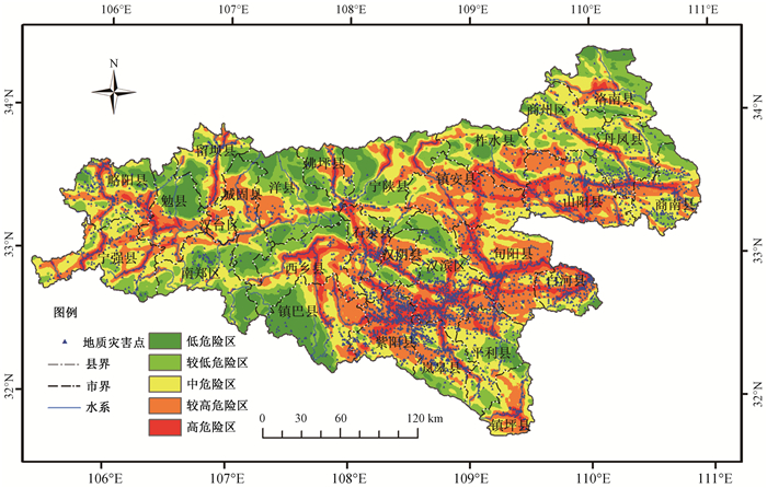
表 4 危险性评价结果统计
Table 4. Statistical results of risk assessment
危险性等级 发生灾害的
栅格数b栅格总数
c灾害比例
(b/c)/%占发生灾害栅格
总数比例/%占栅格总数
比例/%灾点密度/
100 km2高 1029830 1037557 99.26 29.45 10.52 21.34 较高 1237287 2792448 44.31 35.38 28.30 9.48 中 886292 2978551 29.76 25.34 30.19 6.57 较低 258923 2023478 12.80 7.40 20.51 2.99 低 85083 1033906 8.23 2.43 10.48 1.97
下载: 导出CSV
-
[1] 黄润秋, 向喜琼, 巨能攀.我国区域地质灾害评价的现状及问题[J].地质通报, 2004, 23(11):1078-1082. doi: 10.3969/j.issn.1671-2552.2004.11.005HUANG Runqiu, XIANG Xiqiong, JU Nengpan. Assessment of China's regional geohazards:present situation and problems[J]. Geological Bulletin of China, 2004, 23(11):1078-1082. (in Chinese with English abstract(in Chinese with English abstract) doi: 10.3969/j.issn.1671-2552.2004.11.005 [2] 陈奇, 李智毅, 石怀伦.区域地质灾害危险性评价的思路与基本方法[J].地质力学学报, 2004, 10(1):71-80. doi: 10.3969/j.issn.1006-6616.2004.01.010CHEN Qi, LI Zhiyi, SHI Huailun. Thoughts and basic methods of regional geological hazard risk assessment[J]. Journal of Geomechanics, 2004, 10(1):71-80. (in Chinese with English abstract(in Chinese with English abstract) doi: 10.3969/j.issn.1006-6616.2004.01.010 [3] CARRARA A, CARDINALI M, DETTI R, et al. GIS techniques and statistical models in evaluating landslide hazard[J]. Earth Surface Processes and Landforms, 1991, 16(5):427-445. doi: 10.1002/esp.3290160505 [4] MEJIA-NAVARRO M, WOHL E E, OAKS S D. Geological hazards, vulnerability, and risk assessment using GIS:model for Glenwood Springs, colorado[J]. Geomorphology, 1994, 10(1-4):331-354. doi: 10.1016/0169-555X(94)90024-8 [5] Gupta R P, Joshi B C. Landslide hazard zoning using the GIS approach-a case study from the Ramganga catchment, Himalayas[J]. Engineering Geology, 1990, 28(1-2):119-131. doi: 10.1016/0013-7952(90)90037-2 [6] 汪华斌, 吴树仁, 汪微波.滑坡灾害空间智能预测展望[J].地质科技情报, 2008, 27(2):17-20. doi: 10.3969/j.issn.1000-7849.2008.02.003WANG Huabin, WU Shuren, WANG Weibo. A framework for intelligent prediction of landslide hazards[J]. Geological Science and Technology Information, 2008, 27(2):17-20. (in Chinese with English abstract(in Chinese with English abstract) doi: 10.3969/j.issn.1000-7849.2008.02.003 [7] 张桂荣, 殷坤龙, 刘传正, 等.基于GIS的陕西省旬阳地区滑坡灾害危险性区划[J].中国地质灾害与防治学报, 2003, 14(4):39-43. doi: 10.3969/j.issn.1003-8035.2003.04.008ZHANG Guirong, YIN Kunlong, LIU Chuanzheng, et al. The hazard zoning of landslide supported by GIS in Xunyang region of Shanxi Province[J]. The Chinese Journal of Geological Hazard and Control, 2003, 14(4):39-43. (in Chinese with English abstract(in Chinese with English abstract) doi: 10.3969/j.issn.1003-8035.2003.04.008 [8] 张春山, 韩金良, 孙炜锋, 等.陕西陇县地质灾害危险性分区评价[J].地质通报, 2008, 27(11):1795-1801. doi: 10.3969/j.issn.1671-2552.2008.11.006ZHANG Chunshan, HAN Jinliang, SUN Weifeng, et al. Assessments of geohazard danger zoning in Longxian County, Shaanxi, China[J]. Geological Bulletin of China, 2008, 27(11):1795-1801. (in Chinese with English abstract(in Chinese with English abstract) doi: 10.3969/j.issn.1671-2552.2008.11.006 [9] 牛全福, 程维明, 兰恒星, 等.基于信息量模型的玉树地震次生地质灾害危险性评价[J].山地学报, 2011, 29(2):243-249. doi: 10.3969/j.issn.1008-2786.2011.02.014NIU Quanfu, CHENG Weiming, LAN Hengxing, et al. Susceptibility assessment of secondary geological disaster based on information value methodology for Yushu earthquake region[J]. Journal of Mountain Science, 2011, 29(2):243-249. (in Chinese with English abstract(in Chinese with English abstract) doi: 10.3969/j.issn.1008-2786.2011.02.014 [10] 邓辉, 何政伟, 陈晔, 等.信息量模型在山地环境地质灾害危险性评价中的应用:以四川泸定县为例[J].自然灾害学报, 2014, 23(2):67-76. http://www.cnki.com.cn/Article/CJFDTotal-ZRZH201402010.htmDENG Hui, HE Zhengwei, CHEN Ye, et al. Application of information quantity model to hazard evaluation of geological disaster in mountainous region environment:a case study of Luding County, Sichuan Province[J]. Journal of Natural Disasters, 2014, 23(2):67-76. (in Chinese with English abstract(in Chinese with English abstract) http://www.cnki.com.cn/Article/CJFDTotal-ZRZH201402010.htm [11] 杜春兰, 陆文凤, 李剑锋, 等.地质灾害危险度研究:以重庆市渝北区为例[J].地下空间与工程学报, 2008, 4(6):1169-1176. http://d.old.wanfangdata.com.cn/Periodical/gl200903012DU Chunlan, LU Wenfeng, LI Jianfeng, et al. Analysis on the hazard degree of geological disasters[J]. Chinese Journal of Underground Space and Engineering, 2008, 4(6):1169-1176. (in Chinese with English abstract(in Chinese with English abstract) http://d.old.wanfangdata.com.cn/Periodical/gl200903012 [12] 张丽, 李广杰, 周志广, 等.基于灰色聚类的区域地质灾害危险性分区评价[J].自然灾害学报, 2009, 18(1):164-168. doi: 10.3969/j.issn.1004-4574.2009.01.025ZHANG Li, LI Guangjie, ZHOU Zhiguang, et al. Grey clustering method-based zoning assessment of regional geological disaster[J]. Journal of Natural Disasters, 2009, 18(1):164-168. (in Chinese with English abstract(in Chinese with English abstract) doi: 10.3969/j.issn.1004-4574.2009.01.025 [13] 齐信, 黄波林, 刘广宁, 等.基于GIS技术和频率比模型的三峡地区秭归向斜盆地滑坡敏感性评价[J].地质力学学报, 2017, 23(1):97-104. doi: 10.3969/j.issn.1006-6616.2017.01.005QI Xin, HUANG Bolin, LIU Guangning, et al. Landslide susceptibility assessment in the three gorges area, China, Zigui Synclinal Basin, using GIS technology and frequency ratio model[J]. Journal of Geomechanics, 2017, 23(1):97-104. (in Chinese with English abstract(in Chinese with English abstract) doi: 10.3969/j.issn.1006-6616.2017.01.005 [14] 强菲, 赵法锁, 党亚倩.陕南秦巴山区地质灾害与影响因素的相关性分析[J].南水北调与水利科技, 2015, 13(3):557-562. http://d.old.wanfangdata.com.cn/Periodical/nsbdyslkj201503035QIANG Fei, ZHAO Fasuo, DANG Yaqian. Correlation analysis between geological hazards and impact factors in Qinling-Daba mountains of south Shaanxi Province[J]. South-to-North Water Transfers and Water Science & Technology, 2015, 13(3):557-562. (in Chinese with English abstract(in Chinese with English abstract) http://d.old.wanfangdata.com.cn/Periodical/nsbdyslkj201503035 [15] 赵法锁, 王雁林, 胡志平, 等.陕西省地震灾区地质灾害发育与分布规律研究报告[R].西安: 长安大学, 2012: 12-40.ZHAO Fasuo, WANG Yanlin, HU Zhiping, et al. Study report of Geo-hazard development and distribution in the disaster area of Shaanxi province caused by Wenchuan earthquake[R]. Xi'an:Chang'an University, 2012:12-40. (in Chinese) [16] 殷坤龙.滑坡灾害预测预报[M].武汉:中国地质大学出版社, 2004:24-26.YIN Kunlong. Landslide hazard prediction and evaluation[M]. Wuhan:China University of Geosciences Press, 2004:24-26. (in Chinese) [17] 王佳佳, 殷坤龙, 肖莉丽.基于GIS和信息量的滑坡灾害易发性评价:以三峡库区万州区为例[J].岩石力学与工程学报, 2014, 33(4):797-808. http://d.old.wanfangdata.com.cn/Periodical/yslxygcxb201404018WANG Jiajia, YIN Kunlong, XIAO Lili. Landslide susceptibility assessment based on GIS and weighted information value:a case study of Wanzhou district, three gorges reservoir[J]. Chinese Journal of Rock Mechanics and Engineering, 2014, 33(4):797-808. (in Chinese with English abstract(in Chinese with English abstract) http://d.old.wanfangdata.com.cn/Periodical/yslxygcxb201404018 [18] 张俊, 殷坤龙, 王佳佳, 等.三峡库区万州区滑坡灾害易发性评价研究[J].岩石力学与工程学报, 2016, 35(2):284-296. http://www.wanfangdata.com.cn/details/detail.do?_type=perio&id=yslxygcxb201602009ZHANG Jun, YIN Kunlong, WANG Jiajia, et al. Evaluation of landslide susceptibility for Wanzhou district of three gorges reservoir[J]. Chinese Journal of Rock Mechanics and Engineering, 2016, 35(2):284-296. (in Chinese with English abstract(in Chinese with English abstract) http://www.wanfangdata.com.cn/details/detail.do?_type=perio&id=yslxygcxb201602009 [19] 阮沈勇, 黄润秋.基于GIS的信息量法模型在地质灾害危险性区划中的应用[J].成都理工大学学报(自然科学版), 2001, 28(1):89-92. doi: 10.3969/j.issn.1671-9727.2001.01.018RUAN Shenyong, HUANG Runqiu. Application of GIS-based information model on assessment of geological hazards risk[J]. Journal of Chengdu University of Technology, 2001, 28(1):89-92. (in Chinese with English abstract(in Chinese with English abstract) doi: 10.3969/j.issn.1671-9727.2001.01.018 -

 下载:
下载:


计量
- 文章访问数: 596
- HTML全文浏览量: 208
- PDF下载量: 67
- 被引次数: 0
