

GRAIN SIZE CHARACTERISTICS OF TIANHENGSHAN CORE AND THEIR INDICATIONS FOR STRATIGRAPHIC DIVISION IN THE EASTERN PART OF THE NORTHEAST PLAIN OF CHINA
-
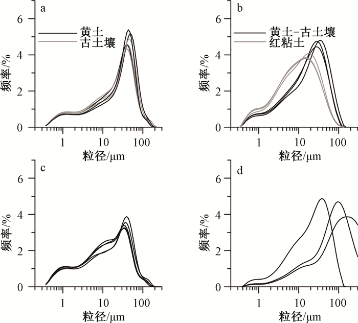
摘要: 东北平原东部荒山剖面是我国东北地区的第四纪典型剖面,但针对该剖面的地层划分和成因的研究尚存在不同看法,对其开展详细的粒度特征研究有望对该剖面的地层划分和地层成因提供进一步的认识。通过天恒山(THS)钻孔对该区地层进行高分辨率的粒度特征研究,并与黄土高原典型黄土进行对比。研究结果显示哈尔滨组地层平均粒径、中值粒径以及粒级百分含量等大幅度波动,呈现黄土-古土壤地层旋回变化特征,黄土层粒度粗,古土壤层粒度细,与黄土高原典型第四纪黄土的粒度特征一致。荒山组地层则呈现小幅度波动,沉积动力较稳定。哈尔滨组和荒山组的粒度频率分布、C-M图及粒度参数(平均粒径、标准偏差、偏度、峰度)等特征均存在显著差别,指示二者的沉积动力过程明显不同。基于以上粒度特征,结合沉积相特征和已有划分方法,THS钻孔中-晚更新世地层自上而下可划分为哈尔滨组和荒山组,并将哈尔滨组地层判定为风成堆积,将荒山组地层判定为河湖相沉积。Abstract: Huangshan Profile in the eastern part of the Northeast Plain is a typical Quaternary profile in Northeast China; however, there are different views on the stratigraphic division and stratigraphic origin of this section. A detailed study on its grain size characteristics is expected to provide further insight into the stratigraphic division and stratigraphic origin of the profile. In this paper, high resolution grain size characteristics of the sediments in Tianhengshan (THS) Core were studied and compared with those in typical loess profiles on the Chinese Loess Plateau. The results show that the mean grain size, median grain size and percentage fraction of grain size of Harbin Formation fluctuated widely, with coarser grains in the loess layer and finer ones in the paleosol layer, similar to those in the loess-paleosol sequence on the Chinese Loess Plateau. However, grain size characteristics in Huangshan Formation show small fluctuations, thus indicating relatively stable sedimentary dynamics. The characteristics of grain size, including frequency distribution, C-M diagram and other grain size parameters (mean grain size, standard deviation, skewness and kurtosis) in sediments between Harbin Formation and Huangshan Formation are obviously different, indicating that the sedimentary dynamics of the two groups are different. Based on the above characteristics of grain size, combining sedimentary facies and previous methods of classification, the middle-to late-Pleistocene strata of the THS Core from top to bottom is divided into Harbin Formation and Huangshan Formation, which are determined as aeolian accumulation and fluvial/lacustrine sediment, respectively.
-
Key words:
- the Northeast Plain /
- Huangshan section /
- Harbin Formation /
- Huangshan Formation /
- grain size
-

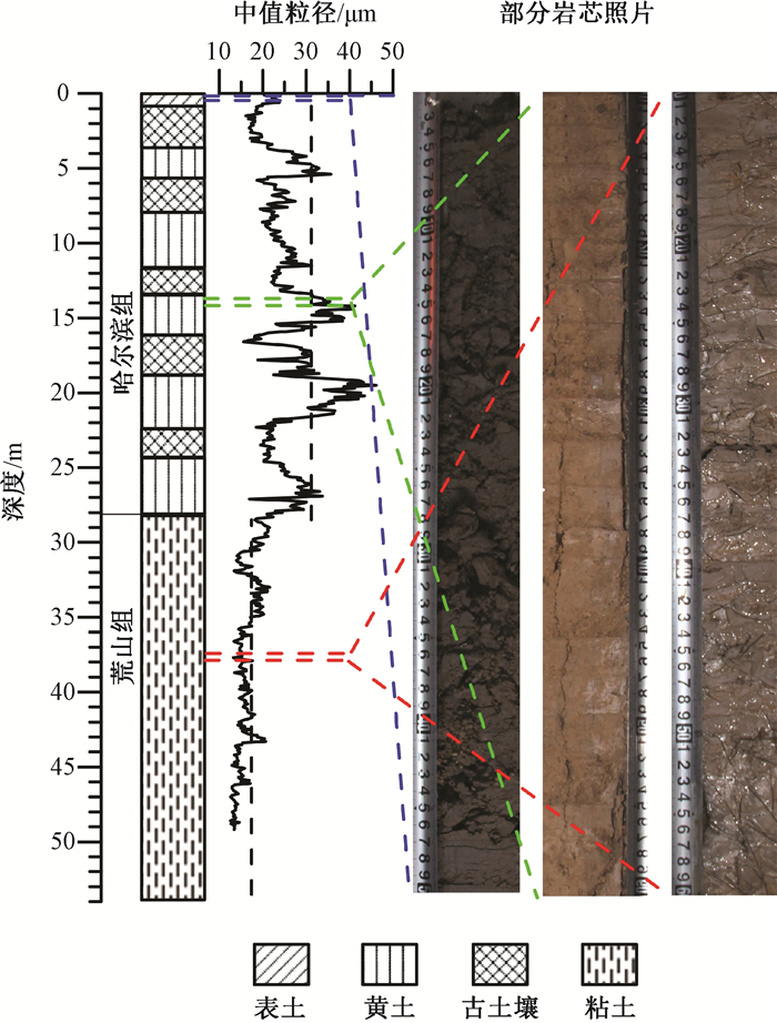
图 2 THS钻孔的岩性柱状图、中值粒径及部分岩芯照片
Figure 2. The lithology, median diameter and photos of THS core

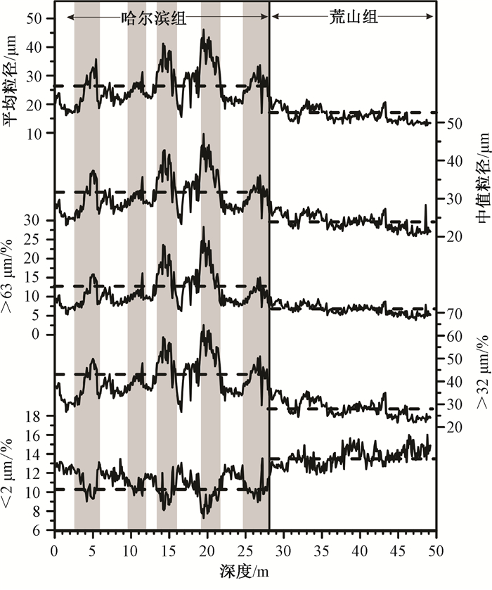
图 3 THS钻孔沉积物平均粒径、中值粒径以及各粒级组分百分含量随地层深度的变化
(灰色阴影代表黄土层)
Figure 3. Variations of average grain size, median diameter, and percentage content of each particle fraction in the THS core with the depth of the stratum (grey shadow represents loess layer)


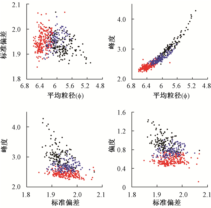
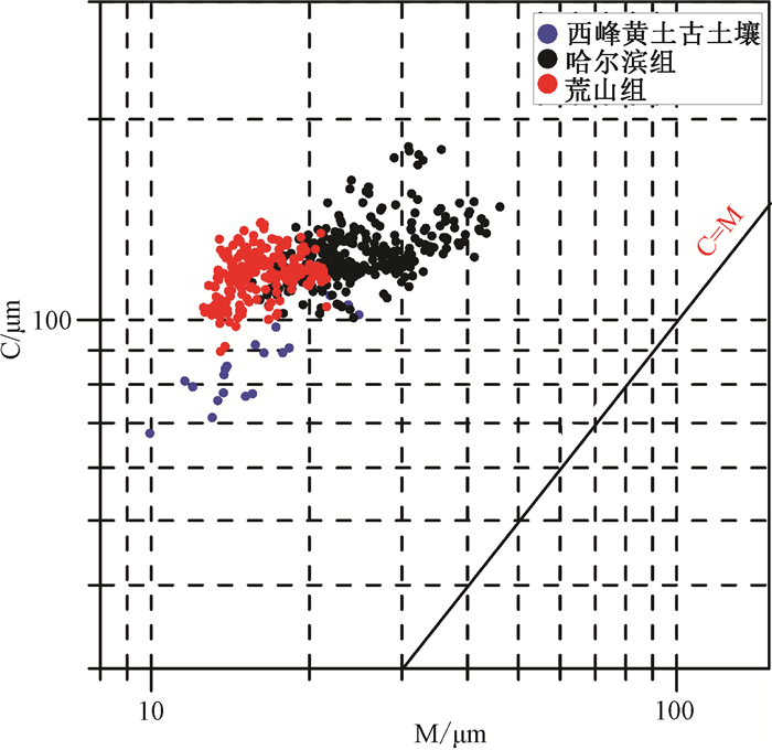
图 6 THS钻孔哈尔滨组和荒山组地层样品的粒度参数(phi值)散点图
黑色圆点—哈尔滨组黄土层样品;蓝色圆点—哈尔滨组古土壤层样品;红色圆点—荒山组样品
Figure 6. Grain-size parameters (phi value) scatterplot of Harbin and Huangshan Formation in THS core
-
[1] 吴锡浩, 浦庆余, 钱方, 等.松辽平原第四纪磁性地层的初步研究[J].海洋地质与第四纪地质, 1984, 4(2):1~13. http://www.cnki.com.cn/Article/CJFDTOTAL-HYDZ198402000.htmWU Xihao, PU Qingyu, QIAN Fang, et al. Preliminary study on the Quaternary magnetostratigraphy of the Songliao plain in north-east China[J]. Marine Geology & Quaternaty Geology, 1984, 4(2):1~13. (in Chinese with English abstract) http://www.cnki.com.cn/Article/CJFDTOTAL-HYDZ198402000.htm [2] 初本君, 高振超, 杨世生, 等.黑龙江省第四纪地质与环境[M].北京:海洋出版社, 1988.CHU Benjun, GAO Zhencao, YANG Shisheng, et al. Quaternary geology and environment of Heilongjiang province, China[M]. Beijing:Ocean Press, 1988. (in Chinese) [3] 叶启晓.哈尔滨地区第四系[J].黑龙江地质, 1991, 2(2):17~29. http://www.wanfangdata.com.cn/details/detail.do?_type=perio&id=kjyqy201207136YE Qixiao. Quaternary system in Harbin area[J]. Heilongjiang Geology, 1991, 2(2):17~29. (in Chinese with English abstract) http://www.wanfangdata.com.cn/details/detail.do?_type=perio&id=kjyqy201207136 [4] 魏传义, 李长安, 康春国, 等.哈尔滨黄山黄土粒度特征及其对成因的指示[J].地球科学——中国地质大学学报, 2015, 40(12):1945~1954. http://www.cqvip.com/QK/94035X/201512/666921734.htmlWEI Chuanyi, LI Chang'an, KANG Chunguo, et al. Grain-size characteristics and genesis of the Huangshan Loess in songnen plain area[J]. Earth Science——Journal of China University of Geosciences, 2015, 40(12):1945~1954. (in Chinese with English abstract) http://www.cqvip.com/QK/94035X/201512/666921734.html [5] Doeglas D J. Grain-size indices, classification and environment[J]. Sedimentology, 1968, 10(2):83~100. doi: 10.1111/sed.1968.10.issue-2 [6] Visher G S. Grain size distributions and depositional processes[J]. Journal of Sedimentary Research, 1969, 39(3):1074~1106. https://www.researchgate.net/publication/250081511_Grain_Size_Distributions_and_Depositional_Processes [7] Lu H Y, Vandenberghe J, An Z S. Aeolian origin and palaeoclimatic implications of the 'red clay' (north China) as evidenced by grain-size distribution[J]. Journal of Quaternary Science, 2001, 16(1):89~97. doi: 10.1002/(ISSN)1099-1417 [8] Guo Z T, Ruddiman W F, Hao Q Z, et al. Onset of Asian desertification by 22 Myr ago inferred from loess deposits in China[J]. Nature, 2002, 416(6877):159~163. doi: 10.1038/416159a [9] Yang S L, Ding Z L. Comparison of particle size characteristics of the Tertiary 'red clay' and Pleistocene loess in the Chinese Loess Plateau:implications for origin and sources of the 'red clay'[J]. Sedimentology, 2004, 51(1):77~93. doi: 10.1046/j.1365-3091.2003.00612.x [10] Ding Z L, Derbyshire E, Yang S L, et al. Stacked 2.6-Ma grain size record from the Chinese loess based on five sections and correlation with the deep-sea δ18O record[J]. Paleoceanography, 2002, 17(3):1033. doi: 10.1029/2001PA000725/full [11] Sun D H. Monsoon and westerly circulation changes recorded in the late Cenozoic aeolian sequences of Northern China[J]. Global and Planetary Change, 2004, 41(1):63~80. doi: 10.1016/j.gloplacha.2003.11.001 [12] Guo Z T, Sun B, Zhang Z S, et al. A major reorganization of Asian climate by the early Miocene[J]. Climate of the Past, 2008, 4(3):153~174. doi: 10.5194/cp-4-153-2008 [13] Hao Q Z, Wang L, Oldfield F, et al. Delayed build-up of Arctic ice sheets during 400, 000-year minima in insolation variability[J]. Nature, 2012, 490(7420):393~396. doi: 10.1038/nature11493 [14] Zeng L, Lu H Y, Yi S W, et al. Long-term Pleistocene aridification and possible linkage to high-latitude forcing:New evidence from grain size and magnetic susceptibility proxies from loess-paleosol record in northeastern China[J]. Catena, 2017, 154:21~32. doi: 10.1016/j.catena.2017.02.020 [15] Fan M J, Song C H, Dettman D L, et al. Intensification of the Asian winter monsoon after 7.4 Ma:Grain-size evidence from the Linxia Basin, northeastern Tibetan Plateau, 13.1 Ma to 4.3 Ma[J]. Earth and Planetary Science Letters, 2006, 248(1/2):186~197. https://www.researchgate.net/publication/229234756_Intensification_of_the_Asian_winter_monsoon_after_74_Ma_Grain-size_evidence_from_the_Linxia_Basin_northeastern_Tibetan_Plateau_131_Ma_to_43_Ma [16] Xiao J L, Chang Z G, Si B, et al. Partitioning of the grain-size components of Dali Lake core sediments:evidence for lake-level changes during the Holocene[J]. Journal of Paleolimnology, 2009, 42(2):249~260. doi: 10.1007/s10933-008-9274-7 [17] Jiang H C, Ding Z L. Eolian grain-size signature of the Sikouzi lacustrine sediments (Chinese Loess Plateau):Implications for Neogene evolution of the East Asian winter monsoon[J]. GSA Bulletin, 2010, 122(5~6):843~854. https://pubs.geoscienceworld.org/gsa/gsabulletin/article-abstract/122/5-6/843/125532/eolian-grain-size-signature-of-the-sikouzi [18] Yang S L, Ding Z L. Advance-retreat history of the East-Asian summer monsoon rainfall belt over northern China during the last two glacial-interglacial cycles[J]. Earth and Planetary Science Letters, 2008, 274(3~4):499~510. https://www.sciencedirect.com/science/article/pii/S0012821X08005244 [19] An Z S, Liu T, Lu Y C, et al. The long-term paleomonsoon variation recorded by the loess-paleosol sequence in Central China[J]. Quaternary International, 1990, 7~8:91~95. https://www.sciencedirect.com/science/article/pii/1040618290900423 [20] Porter S C, An Z S. Correlation between climate events in the North Atlantic and China during the last glaciation[J]. Nature, 1995, 375(6529):305~308. doi: 10.1038/375305a0 [21] Sun Y B, Clemens S C, An Z S, et al. Astronomical timescale and palaeoclimatic implication of stacked 3.6-Myr monsoon records from the Chinese Loess Plateau[J]. Quaternary Science Reviews, 2006, 25(1~2):33~48. https://www.sciencedirect.com/science/article/pii/S0277379105002039 [22] 鹿化煜, 安芷生.黄土高原红粘土与黄土古土壤粒度特征对比——红粘土风成成因的新证据[J].沉积学报, 1999, 17(2):226~232. http://www.cqvip.com/QK/95994X/199902/3579460.htmlLU Huayu, AN Zhisheng. Comparison of grain-size distribution of red clay and loess-paleosoil deposits in Chinese loess plateau[J]. Acta Sedimentologica Sinica, 1999, 17(2):226~232. (in Chinese with English abstract) http://www.cqvip.com/QK/95994X/199902/3579460.html [23] 孙东怀, 鹿化煜, DAVID R, 等.中国黄土粒度的双峰分布及其古气候意义[J].沉积学报, 2000, 18(3):327~335. http://www.cnki.com.cn/Article/CJFDTOTAL-JDXK199803013.htmSUN Donghuai, LU Huayu, DAVID R, et al. Bimode grain-size distribution of Chinese Loess and its paleoclimate implication[J]. Acta Sedimentologica Sinica, 2000, 18(3):327~335. (in Chinese with English abstract) http://www.cnki.com.cn/Article/CJFDTOTAL-JDXK199803013.htm [24] 李敬卫, 乔彦松, 王燕, 等.江西九江红土堆积的粒度特征及成因研究[J].地质力学学报, 2009, 15(1):95~104. http://journal.geomech.ac.cn/ch/reader/view_abstract.aspx?flag=1&file_no=20090109&journal_id=dzlxxbLI Jingwei, QIAO Yansong, WANG Yan, et al. Aeolian origin of the red Earth tormation in Jiujiang city of Jiangxi province, China:evidence from grain-size analysis[J]. Journal of Geomechanics, 2009, 15(1):95~104. (in Chinese with English abstract) http://journal.geomech.ac.cn/ch/reader/view_abstract.aspx?flag=1&file_no=20090109&journal_id=dzlxxb [25] Friedman G M, Sanders J E. Principles of sedimentology[M]. New York:Wiley, 1978. [26] Folk R L, Ward W C. Brazos river bar, a study in the significance of grain size parameter[J]. Journal of Sedimentary Research, 1957, 27(1):3~26. doi: 10.1306/74D70646-2B21-11D7-8648000102C1865D [27] Passega R. Grain size representation by CM patterns as a geologic tool[J]. Journal of Sedimentary Research, 1964, 34(4):830~847. doi: 10.1306/74D711A4-2B21-11D7-8648000102C1865D -

 下载:
下载:


计量
- 文章访问数: 319
- HTML全文浏览量: 164
- PDF下载量: 9
- 被引次数: 0
