

STUDY ON THE GUANZHUANGYU LOESS STRATIGRAPHY IN MANGSHAN, ZHENGZHOU
-
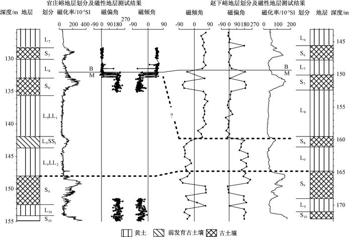
摘要: 邙山官庄峪剖面共厚154.9 m, 出露S10及以上黄土-古土壤地层序列, 特征的马兰黄土厚度达70.125 m, 具有明显的粗粒、均匀特点, 且在该段地层中部, 并没有比较明显的弱古土壤层。磁性地层测量表明B/M界线置于深度132.04 m处, 位于L8的下部; 剖面底部未进入Jaramillo正极性亚时。与赵下峪剖面对比结果显示, 以B/M界线为标志, 72 m以下地层两者高度一致, 只是对地层的划分不同而已; 但赵下峪剖面中比较特征的具有较高磁化率值的L1SS1地层单元, 在官庄峪剖面却无明显表现, 其原因可能需进一步深入研究。Abstract: The thickness of the Guanzhuangyu section in Mangshan is 154.9 m, with the loess-paleosol sequence of S10 and above exposed. The typical malan loess there is coarse grained and uniform with the layer thickness up to 70.125 m, and there is no obvious weakly developed paleosol layer in the middle of this strata. Magnetic stratigraphic measurement indicate that the boundary of B/M is located at the bottom of L8 with the depth of 132.04 m, and the bottom of the profile is not in Jaramillo. Compared with Zhaoxiayu section, it is shown that the heights of the strata below 72 m in both are highly consistent marked by the boundary of B/M, just with different stratigraphic division. However, the magnetic susceptibility values of the stratigraphic unit L1SS1 become apparently higher in Zhaoxiayu section, while there is no obvious change in Guangzhuangyu section. The reason for this phenomenon deserves further research.
-
Key words:
- magnetostratigraphy /
- Guanzhuangyu in Zhengzhou /
- Mangshan loess
-

图 1 郑州邙山官庄峪黄土-古土壤剖面磁性地层序列
Figure 1. Magnetic stratigraphic sequence of Guanzhuangyu loess-paleosol profile in Mangshan, Zhengzhou

图 2 邙山官庄峪黄土-古土壤剖面下部B/M磁性地层序列
Figure 2. The B/M magnetic stratigraphic sequence below Guangzhuangyu loess-paleosol profile

图 3 邙山官庄峪黄土剖面与赵下峪黄土剖面地层对比
Figure 3. Stratigraphy comparison between Guanzhuangyu loess and Zhaoxiayu loess profiles in Mangshan
-
[1] 蒋复初, 吴锡浩, 孙东怀, 等.中原邙山黄土地层[J].地质力学学报, 1998, 4(4):12~18. http://journal.geomech.ac.cn/ch/reader/view_abstract.aspx?flag=1&file_no=19980441&journal_id=dzlxxbJIANG Fu-chu, WU Xi-hao, SUN Dong-huai, et al. On Mangshan loess stratigraphy in China central plains[J]. Journal of Geomechanics, 1998, 4(4): 12~18. http://journal.geomech.ac.cn/ch/reader/view_abstract.aspx?flag=1&file_no=19980441&journal_id=dzlxxb [2] 蒋复初, 吴锡浩, 肖华国, 等.中原邙山黄土及构造与气候耦合作用[J].海洋地质与第四纪地质, 1999, 19(1):45~51. http://www.cnki.com.cn/Article/CJFDTOTAL-HYDZ901.006.htmJIANG Fu-chu, WU Xi-hao, XIAO Hua-guo, et al. Mangshan loess in China central plains and the coupling effect between tectonics and climate[J]. Marine Geology & Quaternary Geology, 1999, 19(1): 45~51. http://www.cnki.com.cn/Article/CJFDTOTAL-HYDZ901.006.htm [3] 吴锡浩, 蒋复初, 肖华国, 等.中原邙山黄土及最近200ka构造运动与气候变化[J].中国科学:D辑, 1999, 29(1):75~81. http://www.cnki.com.cn/Article/CJFDTOTAL-JDXK199901011.htmWU Xi-hao, JIANG Fu-chu, XIAO Hua-guo, et al. Mangshan loess on China's central plain and its response to tectonic movement and climate[J]. Science in China: Series D, 1999, 29(1): 75~81. http://www.cnki.com.cn/Article/CJFDTOTAL-JDXK199901011.htm [4] 蒋复初, 王书兵, 赵志中, 等.中原邙山黄土与末次间期以来古季风特征[J].地质论评, 2004, 50(5):554~560. http://www.cnki.com.cn/Article/CJFDTOTAL-DZLP200405018.htmJIANG Fu-chu, WANG Shu-bing, ZHAO Zhi-zhong, et al. The Mangshan loess in central China and paleomonsoon characteristic since the Last Interglacial Stage[J]. Geological Review, 2004, 50(5): 554~560. http://www.cnki.com.cn/Article/CJFDTOTAL-DZLP200405018.htm [5] Jiang Fuchu, Wang Shubing, Zhao Zhizhong, et al. Mangshan loess in central China and the paleomonsoon variations since the Last Interglaciation[J]. Acta Geologic Sinica: English Edition, 2004, 78(3): 813~819. http://d.wanfangdata.com.cn/Periodical/dzxb-e200403027 [6] Jiang Fuchu, Fu Jianli, Wang Shubing, et al. Formation of the Yellow River, inferred from loess-palaeosol sequence in Mangshan and lacustrine sediments in Sanmen Gorge, China[J]. Quaternary International, 2007, 175: 62~70. doi: 10.1016/j.quaint.2007.03.022 [7] Jin Chunsheng, Liu Qingsong. Revisiting the stratigraphic position of the Matuyama-Brunhes geomagnetic polarity boundary in Chinese loess[J]. Palaeogeography, Palaeoclimatology, Palaeoecology, 2011, 299: 309~317. doi: 10.1016/j.palaeo.2010.11.011 [8] Peterse F, Prins M A, Beets C J, et al. Decoupled warming and monsoon precipitation in East Asia over the last deglaciation[J]. Earth and Planetary Science Letters, 2011, 301: 256~264. doi: 10.1016/j.epsl.2010.11.010 [9] Peterse F, Martínez-García A, Zhou Bin, et al. Molecular records of continental air temperature and monsoon precipitation variability in East Asia spanning the past 130, 000 years[J]. Quaternary Science Reviews, 2014, 83: 76~82. doi: 10.1016/j.quascirev.2013.11.001 [10] 季军良, 郑洪波, 刘锐, 等.邙山黄土地层再研究[J].海洋地质与第四纪地质, 2004, 24(4):101~108. http://www.cnki.com.cn/Article/CJFDTOTAL-HYDZ200404020.htmJI Jun-liang, ZHENG Hong-bo, LIU Rui, et al. Restudy on the stratigraphy of Mangshan loess[J]. Marine Geology & Quaternary Geology, 2004, 24(4): 101~108. http://www.cnki.com.cn/Article/CJFDTOTAL-HYDZ200404020.htm [11] Zheng Hongbo, Huang Xiangtong, Ji Junliang, et al. Ultra-high rates of loess sedimentation at Zhengzhou since Stage 7: Implication for the Yellow River erosion of the Sanmen Gorge[J]. Geomorphology, 2007, 85: 131~142. doi: 10.1016/j.geomorph.2006.03.014 -

 下载:
下载:


图(4)
计量
- 文章访问数: 524
- HTML全文浏览量: 164
- PDF下载量: 13
- 被引次数: 0
