CHRONOLOGY STUDY OF THE QUATERNARY STRATA IN YBK1 CORE IN THE NORTH WING OF THE YANGTZE RIVER DELTA
-
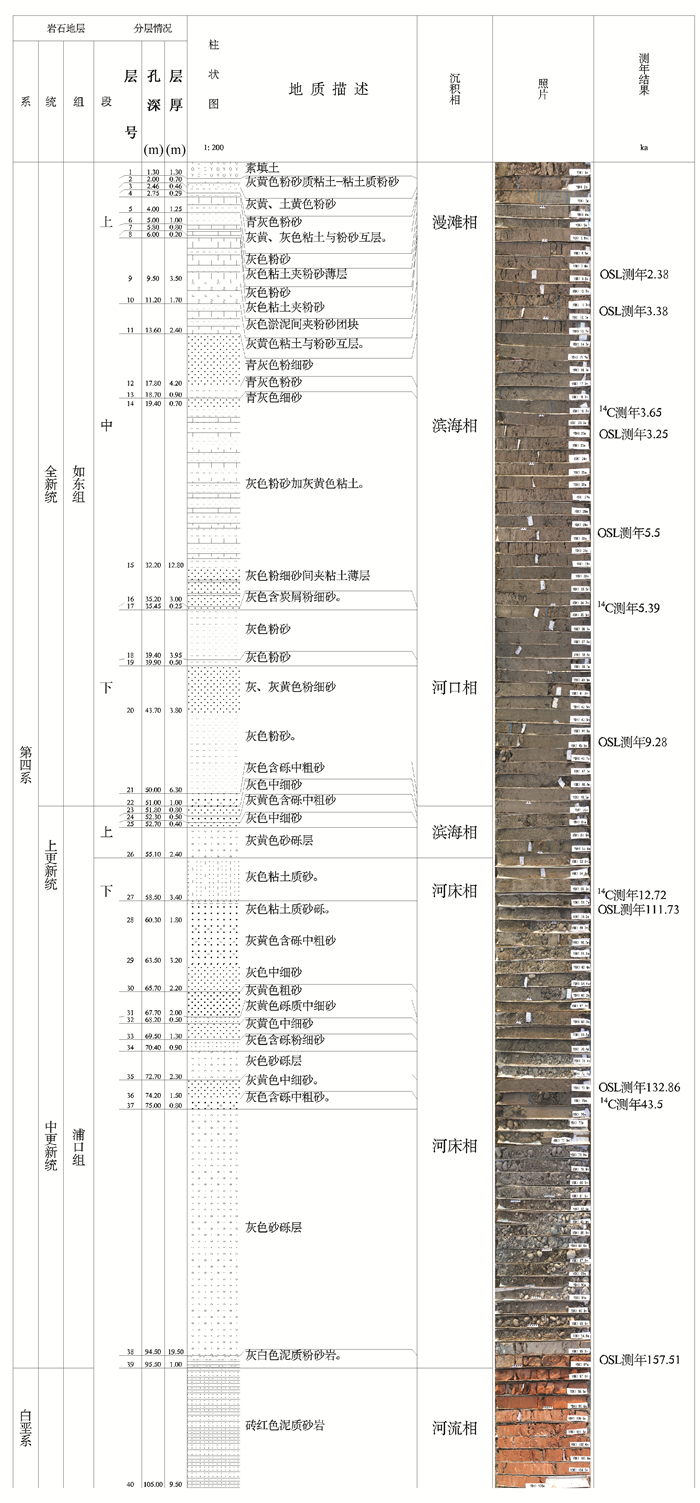
摘要: 第四纪钻孔岩芯时间标尺的建立是分析平原覆盖区第四纪环境演变过程的重要基础。通过分析江苏扬州市施桥镇运河大桥东侧YBK1孔岩芯中总厚度95.50 m的第四纪沉积物的岩性、颜色、物质组成、沉积结构和接触界面形态等特征,并对地层进行详细分层基础上,综合采用AMS14C、光释光、宇生核素埋藏和古地磁等年代测试,建立了YBK1孔的第四纪地层年代标尺。结合地层的结构、构造、标志层等的标志,确定YBK1孔第四纪沉积物下覆地层为白垩系浦口组红色粉砂岩,第四纪地层自上而下可分为4套地层,从老到新分别为:中更新世晚期的启东组上段,发育时代为0.1~0.3 Ma,厚度30.20 m,以河床相砂砾层为主,成分较杂;晚更新世早期的昆山组下段,发育时代为0.1~0.045 Ma,厚度仅1.80 m,以残留的河床相砂砾为主;晚更新世晚期的滆湖组中段,发育时代为0.045~0.01 Ma,厚度仅3.40 m,以海滨形成的灰色粉细砂和灰黄色砂砾层为特征,晚更新世晚期的上段及下段均未见残留;全新世如东组沉积厚度较大,达55.10 m,可进一步分为上、中、下三段,分界年龄约为2.5 Ka和7.5 Ka。该区的全新世以滨海、河口、河漫滩沉积物为主,其厚度突然增大与全新世时期的河床改道密切相关。从YBK1孔的岩性特征分析,研究区域缺失早更新世及中更新世早期沉积物,中更新世晚期至晚更新世时期受河流侵蚀作用影响,以少量残留粗颗粒河床相沉积物为特征;全新世时期,因河流改道,地表水动力条件减弱,沉积了较厚的全新世沉积物。Abstract: The establishment of Quaternary drilling core time rulers is an important basis for analyzing the evolution of the Quaternary environment in the plain areas. After analyzing the lithology, color, material composition, sedimentary structure and interface of the Quaternary sediments with a total thickness of 95.5m in YBK1 core in the east side of Yunhe Bridge in Shiqiao Town, Yangzhou City, dividing the stratum in detail, and using dating methods like AMS14C, OSL, cosmogenic nuclide and paleomagnetism, we finally establish the Quaternary stratigraphic-time ruler of YBK1 core. Combining with the stratigraphic structure, key bed and so on, we determine that the Quaternary sediments is overlying the Pukou group red siltstone, and it is composed of four sets of strata, which from old to new respectively are:the upper part of the early Late-Pleistocene Qidong Group, with age of 0.1~0.3Ma, thickness of 30.20m, sand bed gravel layer as the main stratum with complicated composition; the lower part of the early Late-Pleistocene Kunshan Group, with age of 0.1~0.045Ma, thickness of 1.80m, residual sand bed gravel layer as the main stratum; the middle part of the later Late-Pleistocene Gehu Group, with age of 0.045~0.01Ma, thickness of only 3.40m, littoral facies grey clay sand as the main stratum, no upper and lower parts; the Holocene Rudong Group, with large thickness of 55.10m, which can be further divided into upper, middle and lower sections with demarcation ages of~2.5Ka and~7.5Ka. The Holocene in this area is dominated by coastal sediments, estuaries and floodplains. It is the Holocene river diversion that made the stratum thickness increase suddenly. According to the lithological characteristics of YBK1 core, Early-Pleistocene and Early-Middle-Pleistocene sediments are non-existent, sediments of Late-Middle-Pleistocene to Late-Pleistocene are affected by river erosion, resulting of depositing a small amount of residual coarse grain river bed sediments. Up to Holocene, the weakening of surface hydrodynamic forces caused by river diversion produced the thicker Holocene sediments.
-
Key words:
- chronology /
- Quaternary Strata /
- the north wing of the Yangtze River Delta
-
0. 引言
水溶天然气(简称水溶气)是指溶解在地层水中的以甲烷气为主的气体,属于非常规油气资源。全球已查明的水溶气资源量非常丰富,盆地中地层水溶性天然气资源量约为33837×1012 m3,为常规天然气资源量的一百多倍。在日本、美国、俄罗斯、乌克兰、哈萨克斯坦、乌兹别克斯坦、阿塞拜疆、土库曼斯坦、匈牙利、意大利、菲律宾、尼泊尔、伊朗等国都发现了水溶天然气,并开展了勘探、开发及地质综合研究。尤其在日本,大约四分之一国土都发现了水溶气,目前,开采量约为10×108 m3/a,并累计了70多年的勘探开发工作经验[1]。
从理论上讲,水溶气资源的分布领域较常规天然气的分布领域更加广泛[1]。但由于水溶气目前还属于一个新型非常规能源,研究程度较低,所以对水溶气层的判断开发还没有一个统一的标准。
渭河盆地位于陕西省中部(关中平原),是秦岭造山带与鄂尔多斯盆地2个大地构造单元接合部位的新生代断陷盆地,其地层属华北地层区南缘分区。研究区固市凹陷位于渭河盆地东部,属于渭河盆地的一个次级凹陷[2~3]。在固市凹陷地热勘探过程中,钻至第三系张家坡组时发生甲烷天然气井喷,发现了水溶甲烷气藏。对浅层气水层的识别通常是依据单纯的常规测井电阻率曲线变化及补偿声波是否发生周波跳跃来进行快速简单的判断。但由于水溶气属于非常规能源,水气互溶,常规测井解释的气层和水层相互干扰较大,而且补偿声波测井对其常常有误判[4]。从试气结果来看,该方法对本地区的非常规水溶甲烷气藏应用效果不明确,必须配合其他的测井手段进行综合分析,建立一套适合本区储层特征的气水层识别方法和标准。
1. 储层特征及气藏类型
研究区地层为第三系,埋藏较浅,一般小于2000 m,属于湖相沉积。固市凹陷在实际工作中划分为3种储层类型,即含水气层、气水同层、含气水层(包含差气层)。储层圈闭类型为岩性圈闭,在横向上对比较整齐,储层段气水互溶性好,为自生自储的非常规气藏,具有统一的气水界面[4~5]。从已有的岩心分析资料看,该区储层孔隙度虽较高,但由于岩石结构和成分成熟度均低,颗粒大小混杂,分选差,杂基含量较高[6~7],所以渗透率中等,仅偶尔出现较高的渗透率,表现出高孔中渗的物性特征。总体上来说储层岩性粒度较细,砂泥互层较发育,岩性界面较模糊且灰质含量较高,储层横向展布对比较稳定。
2. 气水层识别难点
2.1 地层气水互溶对测井识别的影响
由岩心实验数据得知,储层中游离水和束缚水含量不同。研究区可采水溶气一般赋存于游离水中,在高含气储层段,游离水含量高;而差气层束缚水含量高,游离水含量相对较低,因此形成高含气水层和低含气水层。高含气水层和低含气水层含水均较高,从而导致储层和水层在声波时差和电阻率上的差异较小,造成常规测井对气层和水层极难识别[4]。
2.2 测井曲线受岩性的影响
正常情况下,储层含气易使声波时差明显增大,甚至有可能发生周波跳跃;但当储层岩性较松散或含水较多时可能会引起声波时差变化不大,不易区别储层与含水层。研究区地层属于第三系,埋藏较浅,未经过强压实作用,故岩性疏松;加之水溶气藏气水互溶,使得补偿声波测井在该区的储层时差变化较小,区分气水层效果非常不明显。此外对于水溶气藏,研究区储层与非储层的含水都较高而导致电性特征差异小,因此电测井对水溶甲烷气水层的识别也较困难。
2.3 地质构造对测井识别的影响
宏观上渭河盆地构造断层较多,小断层较发育,但本区凹陷被小断层所包围,内部连续稳定。东西向较大规模的断裂造成渭河盆地南北边缘形成一系列东西向展布的断阶,北东向或北西向断层相互切割,形成众多大小不一的次级凹陷,各个凹陷互相独立,形成自生自储式气藏[1]。研究区是位于渭河盆地东部的次一级凹陷,储层横向上连通性接触关系较好,小层对比较稳定,因此气水连通互溶性好,测井曲线对气水互溶层响应差异较小,导致气水层较难判别。
3. 气水层识别方法
3.1 利用孔隙度重叠法和常规测井曲线快速直观识别气水层
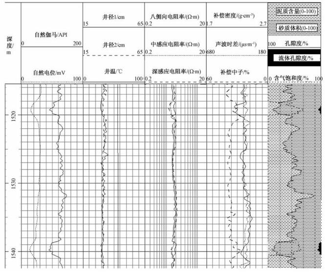
本文通过自然电位曲线和自然伽马曲线特征(电位负异常、低自然伽马)大致判断出渗透性砂岩储层[8];然后结合三电阻率(八侧向电阻率、中感应电阻率、深感应电阻率)的差异显示,对渗透层判别气水层,高中电阻处应为高含气层,低电阻为水层。应用标准化后的三孔隙度(补偿密度、声波时差、补偿中子)曲线在储层处重叠,并采用相同的视孔隙度横向比例显示,依据水溶气层的特殊响应特征进行判别:补偿声波孔隙度在水溶气层变化不大,处于基值,所以小于补偿中子和补偿密度孔隙度;补偿中子测井在水溶气层处“挖掘效应”不明显,所以补偿中子孔隙度大于补偿密度孔隙度和补偿声波孔隙度,这样在气层处三孔隙度曲线便出现明显的特征差异[9],用这种方法能快速直观地判别储层与非储层(见图 1)。
3.2 利用测井孔隙度差值比值法(孔隙参数法)进行气水层识别
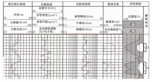
本文借鉴云南保山盆地的气水识别方法[4, 10~11],结合研究区实际地层特点,总结出一套以三孔隙度的差值及比值(即孔隙参数)法识别气水层。具体方法是:分别计算标准化后的三孔隙度的比值及差值,放大气层在三孔隙度测井曲线上的响应信息,利用孔隙度比值重叠显示和孔隙度差值对称显示,从而更加清楚地判断储层含气性。在张家坡组储层水溶气水层识别中,运用三孔隙度差值和比值(孔隙参数)法结合其他常规测井信息综合识别气水层效果较好(见图 2)。
由于目的层段属于浅层的水溶气层,压实作用不强烈且受水气互溶因素的影响,具体实例中应用的都是标准化后的数据。由三孔隙度测井资料提取如下6种气层孔隙参数:DCD为视中子孔隙度与视密度孔隙度之差,DCA为视中子孔隙度与视声波孔隙度之差,DDA为视密度孔隙度与视声波孔隙度之差;RCD为视中子孔隙度与视密度孔隙度比值,RCA为视中子孔隙度与视声波孔隙度比值,RDA为视密度孔隙度与视声波孔隙度比值。
对储层运用孔隙参数法,当孔隙参数DCD、DCA、DDA、RCD、RCA、RDA均大于1,并当DCD、DCA、RCD、RCA越小且越接近1,同时DDA、RDA越大时,判定气层可能性越大;各个孔隙参数的区间值分别指示了含水气层、气水同层和含气水层(差气层)的区别。通过对试气层孔隙参数与电阻率及各测井曲线综合对比交会,可确定这6个孔隙参数识别气水层的区间标准[12~13]。
3.3 根据气测录井全烃资料确定气水层识别标准
研究区气测录井资料为电脱气测,根据录井全烃变化的特点,采用全烃的净增值法、比值法、显示厚度与测井资料厚度比值(饱满系数)法建立了研究区内气测识别气水层的标准。
3.4 结合TNIS成像测井成果图综合分析
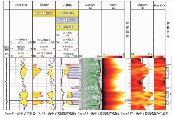
本文不仅对常规测井资料进行分析研究,而且结合了TNIS过套管成像测井,进一步对研究区浅层的气水层进行判别。TNIS过套管成像测井原理是:使用高能的中子发生器向地层发射14 MeV的快中子,经过一系列弹性与非弹性碰撞,最后被地层俘获,利用仪器上2个中子探测器得到的中子计数的比值可以计算出储层的含氢指数,进而计算孔隙度,判别气水层。如图 3所示,本区TNIS过套管成像测井结果显示,热中子俘获谱、衰减成像、俘获成像均表现为异常变高,黄色指示,判断为气层,与孔隙参数法及综合测井结论相吻合,确定了该方法在本研究区的适用性。
3.5 储层气水层识别标准的对比确立
综合测井资料及气测录井、TNIS过套管成像测井资料,建立了该区储层的浅层水溶气水层识别区间标准(见表 1)。
表 1 气水层综合判别标准Table 1. Comprehensive discriminant standard of gas-and water-bearing layers
4. 应用实例
如图 2所示的单井气层判别情况,从图中可以看出,自然电位和自然伽马曲线表现异常,显示为典型的渗透层,三孔隙度差异明显,显示出明显的高孔隙层位,根据孔隙参数法计算出的孔隙参数:DCA=35,DCD=10,DDA=50,RCD=1.024,RCA=1.162,RDA=1.135,气测全烃从1%上升到6%,净增值5%,比值为6,饱满系数为1.1,以上参数都符合气层的综合判别标准,并且TNIS成像测井成果图也同样解释了该层为明显的含气异常层,故解释为含水气层,与试气结论相吻合。这类储层在以前解释时都比较困难,与水层、含气水层很难区分,但通过该套方法的建立,放大了测井信息,能较准确的识别出含气储层。
通过建立的标准,对所有试气的储层(28层)进行了综合判断,14个含水气层,10个气水同层,4个含气水层(包含差气层),与现场实际试气成果符合率达到90%。
5. 结论
结合气测录井资料,建立了一套适用于渭河盆地固市凹陷第三系张家坡组浅层疏松砂岩储层水溶气水层的识别方法,利用孔隙度重叠法、孔隙度差值及比值法(孔隙参数法)和适合于本地区的综合测井的补偿中子曲线与电阻率曲线对比分析法、TNIS成像测井综合识别水溶气水层的方法和标准。
放大了气层在三孔隙度测井曲线上的响应信息;结合气测全烃资料的净增值、比值等参数,对储层的含气性质进行综合判断,在很大程度上解决了解释中存在的气水层识别困难问题。
参照该方法对本研究区28个层段进行分析研究,与实际生产的试气对比得出,其符合率达90%,应用效果较好。
-
表 1 扬州施桥YBK1孔第四系光释光环境剂量率结果
Table 1. The OSL enviroment dose rates of the YBK1 drill hole at shiqiao of Yangzhou city in Jiangsu province
实验室编号 钾含量K(%) 铀含量U(ppm) 钍含量Th(ppm) 实测含水量(%) B1 1.71±3.2 2.55±4.0 11.1±2.8 35.52 B2 1.55±3.5 2.55±4.0 10.9±2.8 38.81 B3 1.65±3.3 2.27±4.1 13.1±2.8 23.54 B4 1.75±3.2 2.14±4.2 10.1±2.9 37.99 B5 1.94±3.1 3.16±3.7 14.3±2.6 34.43 B6 1.61±3.4 1.68±4.6 8.13±3.1 27.05 B7 1.56±3.5 1.45±4.9 4.41±3.6 5.17 B8 1.91±3.1 2.32±4.1 6.73±3.4 15.49 B9 1.63±3.4 1.64±4.6 7.08±3.3 13.87 B10 2.22±2.9 0.75±6.2 3.20±4.5 18.41 注:数据误差为百分相对误差,表内省略了%。 表 2 扬州施桥YBK1孔第四系光释光(OSL)测年结果
Table 2. The OSL age results of the YBK1 drill hole at shiqiao of Yangzhou city in Jiangsu province
采样地点 样品编号 原始编号 采样深度
/m等效剂量
/Gy剂量率
Gy/KaOSL年代
/ka备注 扬州施桥镇YBK1 B1 YZ-OSL-4 9.3~9.5 4.99±0.44 2.09±0.15 2.38±0.27 结果基本可信 B2 YZ-OSL-5 11.7~11.8 6.3±0.05 1.86±0.14 3.38±0.25 B3 YZ-OSL-7 20.2~20.3 8.18±0.09 2.52±0.19 3.25±0.24 B4 YZ-OSL-9 28.4~28.6 10.29±0.2 1.87±0.14 5.50±0.43 B5 YZ-OSL-10 34.0~34.2 9.26±0.2 2.50±0.19 3.70±0.29 B6 YZ-OSL-11 45.8~46.0 17.98±1.36 1.94±0.15 9.28±0.99 B7 YZ-OSL-13 59.6~59.7 249.48±8.91 2.23±0.17 111.73±9.54 B8 YZ-OSL-15 65.8~66.0 321.50±3.60 2.60±0.20 123.50±9.40 B9 YZ-OSL-16 74.2~74.6 303.24±7.43 2.28±0.17 132.86±10.59 B10 YZ-OSL-18 94.75~94.9 337.89±32.17 2.15±0.17 157.51±19.63 表 3 YBK1孔第四纪沉积物14C测年结果表
Table 3. The 14C age results of the YBK1 drill hole at shiqiao of Yangzhou city in Jiangsu province
原始编号 Beta实验室编号 采样地点 深度 14C年龄/a 备注 YZ-C-7 NJ-7 扬州施桥镇 19.8 m 3650+/-30B.P. 结果均有效 YZ-C-2 NJ-4 35.4 m 5390+/-40B.P. YZ-C-5 NJ-5 58 m 12720+/-50B.P. YZ-C-6 NJ-6 74.8 m >43500B.P. -
[1] 江苏省地质矿产局, 上海经济区地质中心. 长江下游(南京-长江口)河道演变遥感调查报告[R]. 1986.Jiangsu Geology and Mineral Exploration Bureau, Geological Center of Shanghai Economic Region. Remote sensing investigation report of the river channel evolution in the lower reaches of the Yangtze River (Nanjing Changjiang estuary)[R]. 1986. (in Chinese) [2] 江苏省地质矿产局.江苏省及上海市区域地质志[M].北京:地质出版社, 1984.Jiangsu Geology and Mineral Exploration Bureau. Regional geological chronicles of Jiangsu and Shanghai[M]. Beijing:Geological Publishing House, 1984. (in Chinese) [3] 江苏省地质矿产局区调大队. 江苏西南部雨花台组研究报告[R]. 1986.Geological Brigade Surveying Brigade of BGMR. Research Report on the Yuhuatai group in southwestern Jiangsu[R]. 1986. (in Chinese) [4] 陈吉余, 恽才兴, 徐海根, 等.两千年来长江河口发育的模式[J].海洋学报, 1979, 1(1):103~111. http://www.cnki.com.cn/Article/CJFDTOTAL-SEAC197901008.htmCHEN Jiyu, YUN Caixing, XU Haigen, et al. The developmental model of the Chang Jiang river estuary during last 2000 years[J]. Acta Oceanologica Sinica, 1979, 1(1):103~111. (in Chinese with English abstract) http://www.cnki.com.cn/Article/CJFDTOTAL-SEAC197901008.htm [5] Shackleton N J, Opdyke N D. Oxygen-isotope and paleomagnetic stratigraphy of Pacific core V28~239 Late Pliocene to latest Pleistocene[A]. Cune R M, Hays J D. Investigation of Late Quaternary Paleoceanography and Paleoclimatology, GSA Memoirs 145[M]. Washington DC: Geological Society of American, 1976, 449~464. [6] 李从先, 汪品先.长江晚第四纪河口地层学研究[M].北京:科学出版社, 1998.LI Congxian, WANG Pinxian. The study of the estuarine stratigraphy of the late Quaternary in the Yangtze River[M]. Beijing:Science Press, 1998. (in Chinese) [7] 郑祥民, 彭加亮, 郑玉龙.东海海底末次冰期埋藏风尘黄土地层初步研究[J].海洋地质与第四纪地质, 1993, 13(3):49~56. http://www.cnki.com.cn/Article/CJFDTOTAL-HYDZ199303005.htmZHENG Xiangmin, PENG Jialiang, ZHENG Yulong. On the buride Aeolian losee strata of the last glacial period in the floor of the east China Sea[J]. Marine Geology & Quaternary Geology, 1993, 13(3):49~56. (in Chinese with English abstract) http://www.cnki.com.cn/Article/CJFDTOTAL-HYDZ199303005.htm [8] 陈报章, 李从先, 业治铮.冰后期长江三角洲北翼沉积及其环境演变[J].海洋学报, 1995, 17(1):64~75. http://www.hyxb.org.cn/aos/ch/reader/view_abstract.aspx?file_no=19950109CHEN Baozhang, LI Congxian YE Zhizheng. The deposition of the north wing of the Yangtze River Delta and its environmental evolution in the late stage of ice[J]. Acta Oceanologica Sinica, 1995, 17(1):64~75. (in Chinese) http://www.hyxb.org.cn/aos/ch/reader/view_abstract.aspx?file_no=19950109 [9] 李从先, 张桂甲.晚第四纪长江三角洲高分辨率层序地层学的初步研究[J].海洋地质与第四纪地质, 1996, 16(3):13~24. http://www.cqvip.com/Main/Detail.aspx?id=2028580LI Congxian, ZHANG Guijia. A primary study on high-resolution sequence stratigraphy of late quaternary in the Yangtze River delta area[J]. Marine Geology & Quaternary Geology, 1996, 16(3):13~24. (in Chinese with English abstract) http://www.cqvip.com/Main/Detail.aspx?id=2028580 [10] 江苏省地质调查研究院. 1: 25万南京市幅区域地质调查报告[R]. 南宁: 江苏省地质调查研究院, 2003.Geological Survey of Jiangsu Province. A regional geological survey of the 1: 25 million Nanjing[R]. Nanning: Geological Survey of Jiangsu Province, 2003. (in Chinese) [11] 全国地层委员会.中国地层指南及中国地层指南说明书[M].北京:地质出版社, 2001.The National Commission of Stratigraphy. Chinese stratigraphic guide and guide Manual[M]. Beijing:Geological Publishing House, 2001. (in Chinese) [12] 江苏省地质矿产局第三地质大队. 1: 5万扬州市幅、镇江市幅(北部)区域地质调查报告[R]. 1995.The Third Geological Team of Jiangsu Geological and Mineral Bureau. Regional geological survey report of 1: 5 Wan Yangzhou city and Zhenjiang city (North)[R]. 1995. (in Chinese) [13] 江苏省地质调查研究院. 长江三角洲地区(长江以北)环境地质综合调查评价报告[R]. 2011.Geological Survey of Jiangsu Province. Comprehensive survey and evaluation of environmental geology in the Yangtze River Delta region (North of the Yangtze River)[R]. 2011. (in Chinese) [14] 江苏省地质调查研究院. 长江三角洲重点地区(江苏)三维地质调查报告[R]. 2016.Geological Survey of Jiangsu Province. Three dimensional geological survey report of the key region of the Yangtze River Delta (Jiangsu)[R]. 2016. (in Chinese) [15] 吴中海, 周春景, 谭成轩, 等.长江经济带地区活动构造与区域地壳稳定性基本特征[J].地质力学学报, 2016, 22(3):379~411. http://journal.geomech.ac.cn/ch/reader/view_abstract.aspx?file_no=20160301&flag=1WU Zhonghai, ZHOU Chunjing, Tan Chengxuan, et al. The active tectonics and regional crustal stability features in the area of Yangtze River Economic Belt[J]. Journal of Geomechanics, 2016, 22(3):379~410. (in Chinese with English abstract) http://journal.geomech.ac.cn/ch/reader/view_abstract.aspx?file_no=20160301&flag=1 [16] 宗开红, 宗雯, 康丛轩, 等.江苏镇江地区主要活动断裂及其晚第四纪活动性研究[J].地质力学学报, 2016, 22(3):439~453. http://journal.geomech.ac.cn/ch/reader/view_abstract.aspx?file_no=20160305&flag=1ZONG Kaihong, ZONG Wen, KANG Congxuan, et al. Research on the major active faults in Zhenjiang, Jiangsu and their late quaternary activities[J]. Journal of Geomechanics, 2016, 22(3):439~453. (in Chinese with English abstract) http://journal.geomech.ac.cn/ch/reader/view_abstract.aspx?file_no=20160305&flag=1 期刊类型引用(3)
1. 周永刚,戴黎明,田振环,于春楠,张振飞,刘伟,裴伦培. 鲁北平原南部QK4钻孔岩心特征及第四纪地层划分. 物探与化探. 2023(01): 55-64 .  百度学术
百度学术2. 刘宪光,杨晋炜,胡利,夏斌,孙丰瑞,王钜,董军林. 长江三角洲北翼ZKA02孔第四纪多重地层划分研究. 地层学杂志. 2023(01): 49-58 .  百度学术
百度学术3. 申家宁,晏井春,高卫国,钱林波,韩璐,陈梦舫. 多相抽提技术在化工污染地块修复中的应用潜力. 环境工程学报. 2021(10): 3286-3296 .  百度学术
百度学术其他类型引用(3)
-


 下载:
下载:


 下载:
下载:
 百度学术
百度学术
