

POSSIBLE SEISMIC CONTROL ON RIVER CHANNEL CHANGE IN THE LONGMENSHAN MOUNTAIN
-
摘要: 以岷江支流白沙河和涪江支流湔江为例,探讨了2008年汶川地震之后龙门山地区河流形态的变化及其可能的长期构造地貌效应。研究表明,2008年汶川地震地表破裂带穿越河流形成裂点(跌水),地震触发的山体滑坡、泥石流堵塞河道形成堰塞湖,致使河流形态及河流水动力条件随之发生变化。河流同震裂点在震后迅速消失,部分河段出现“裁弯取直”的趋势,这可能与河流中激增的沉积通量有关。随着周期性大地震的复发,河流的沉积-侵蚀过程会不断改变,伴随着震间活动断裂持续的构造变形,龙门山河流形态可能会发生快速变化。Abstract: The 2008 Mw7.9 Wenchuan earthquake induced a large quantity of landslides whose materials entered the river channels. In some channel reach the seismic surface ruptures caused the co-seismic knick points across the channel of the Longmenshan Mountain. The river morphology and hydrodynamic condition may be changed. The field investigations show that co-seismic knick points disappeared rapidly, and meander cut-off would potentially occur in the near future. This suggests that the temporal increase in sediment input will not reduce the long-term fluvial transport capacity. A few years later, the rivers will reach a new state of eroion-transport-deposition. It is concluded that the seismic erosion events (landslide) and local hydrometerological conditions (heavy rainfall and flash flood) exert significant controls on the river channel change in the Longmenshan Mountain.
-
Key words:
- meander cutoff /
- knick point /
- river channel change /
- large earthquake /
- Longmenshan Mountain
-

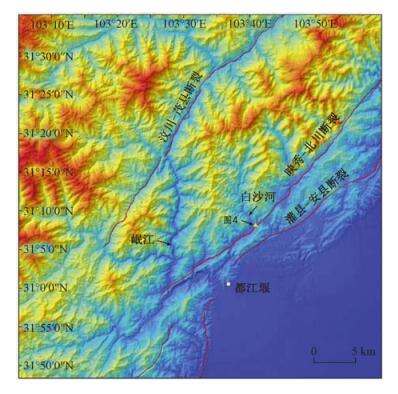
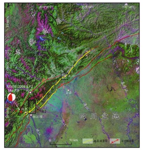
图 1 2008年汶川地震地表破裂空间分布和龙门山地区主要活动构造图
F1-汶川-茂县断裂; F2-映秀-北川断裂; F3-灌县-安县断裂
Figure 1. Spatial distribution of the surface ruptures of the 2008 Wenchuan earthquake and the active faults in the Longmenshan Mountain

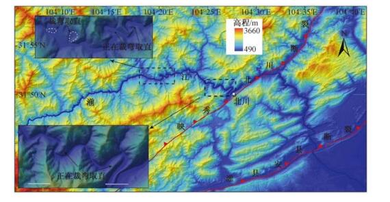
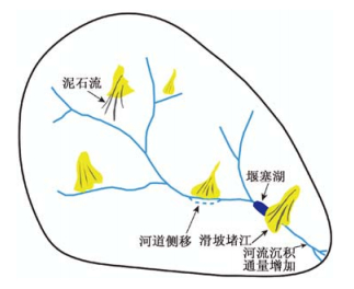
图 3 湔江北川段河流形态(图中显示部分河段已经或正在进行裁弯取直)
Figure 3. The fluvial morphology of the Beichuan reach of the Jianjiang River

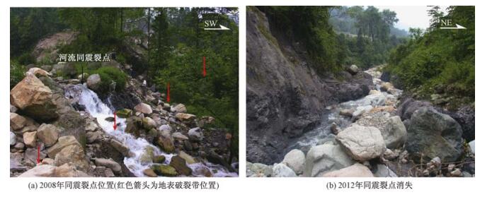
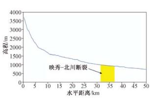
图 4 汶川地震同震裂点位置及其快速消失
Figure 4. The location of the co-seismic knickpoints of the Wenchuan earthquake and their rapid disappearance

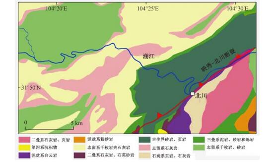
图 7 湔江河流形态与岩性
Figure 7. The fluvial morphology of the Jianjiang River and the lithology
-
[1] Schumm S A. The fluvial system[M]. Wiley-Interscience, 1977. [2] Dai F C, Xu C, Yao X, et al. Spatial distribution of landslides triggered by the 2008Ms8.0 Wenchuan earthquake, China[J]. Journal of Asian Earth Sciences, 2011, 40(4):883~895. doi: 10.1016/j.jseaes.2010.04.010 [3] Wang E C, Meng Q R. Mesozoic and Cenozoic tectonic evolution of the Longmenshan fault belt[J]. Science in China Series D:Earth Sciences, 2009, 52(5):579~592. doi: 10.1007/s11430-009-0053-8 [4] Burchfiel B C, Chen Z L, Liu Y P, et al. Tectonics of the Longmenshan and adjacent region, central China[J]. International Geology Review, 1995, 37(8):661~735. doi: 10.1080/00206819509465424 [5] 邓起东, 陈社发, 赵小麟.龙门山及其邻区的构造和地震活动及动力学[J].地震地质, 1994, 16(4):389~403. http://www.cnki.com.cn/Article/CJFDTOTAL-DZDZ404.013.htmDENG Qi-dong, CHEN She-fa, ZHAO Xiao-lin. Tectonics, seismicity and dynamics of Longmenshan Mountain and its adjacent regions[J]. Seismology and Geology, 1994, 16(4):389~403. http://www.cnki.com.cn/Article/CJFDTOTAL-DZDZ404.013.htm [6] Xu X W, Wen X Z, Yu G H, et al. Coseismic reverse and oblique-slip surface faulting generated by the 2008Mw7.9 Wenchuan earthquake, China[J]. Geology, 2009, 37(6):515~518. doi: 10.1130/G25462A.1 [7] Fu B H, Shi P L, Guo H D, et al. Surface deformation related to the 2008 Wenchuan earthquake, and mountain building of the Longmen Shan, eastern Tibetan Plateau[J]. Journal of Asian Earth Sciences, 2011, 40(4):805~824. doi: 10.1016/j.jseaes.2010.11.011 [8] Qi S W, Xu Q, Lan H X, et al. Spatial distribution analysis of landslides triggered by 20085.12 Wenchuan Earthquake, China[J]. Engineering Geology, 2010, 116(1/2):95~108. http://www.sciencedirect.com/science/article/pii/S0013795210001535 [9] Parker R N, Densmore A L, Rosser N J, et al. Mass wasting triggered by the 2008 Wenchuan earthquake is greater than orogenic growth[J]. Nature Geoscience, 2011, (4):449~452. http://www.nature.com/ngeo/journal/v4/n7/full/ngeo1154.html?foxtrotcallback=true [10] 李智武, 陈洪德, 刘树根, 等.龙门山冲断隆升及其走向差异的裂变径迹证据[J].地质科学, 2010, 45(4):944~968. http://www.cnki.com.cn/Article/CJFDTOTAL-DZKX201004003.htmLI Zhi-wu, CHEN Hong-de, LIU Shu-gen, et al. Differential uplift driven by thrusting and its lateral variation along the Longmenshan belt, western Sichuan, China:Evidence from fission track thermochronology[J]. Chinese Journal of Geology, 2010, 45(4):944~968. http://www.cnki.com.cn/Article/CJFDTOTAL-DZKX201004003.htm [11] Kirby E, Whipple K X, Tang W Q, et al. Distribution of active rock uplift along the eastern margin of the Tibetan Plateau:Inferences from bedrock channel longitudinal profiles[J]. Journal of Geophysical Research, 2003, 108(B4):2217. [12] 贾营营, 付碧宏, 王岩, 等.青藏高原东缘龙门山断裂带晚新生代构造地貌生长及水系响应[J].第四纪研究, 2010, 30(4):825~836. http://www.cnki.com.cn/Article/CJFDTOTAL-DSJJ201004019.htmJIA Ying-ying, FU Bi-hong, WANG Yan, et al. Late Cenozoic tectono-geomorphic growth and drainage response in the Longmen Shan fault zone, east magrin of Tibet[J]. Quaternary Sciences, 2010, 30(4):825~836. http://www.cnki.com.cn/Article/CJFDTOTAL-DSJJ201004019.htm [13] 周荣军, 李勇, Densmore A L, 等.青藏高原东缘活动构造[J].矿物岩石, 2006, 26(2):40~51. http://www.cnki.com.cn/Article/CJFDTOTAL-DQWJ201303004.htmZHOU Rong-jun, LI Yong, Densmore A L, et al. Active tectonics of the eastern margin of the Tibet Plateau[J]. Journal of Mineralogy and Petrology, 2006, 26(2):40~51. http://www.cnki.com.cn/Article/CJFDTOTAL-DQWJ201303004.htm [14] 何宏林, 孙昭民, 魏占玉, 等.汶川Ms8.0地震地表破裂带白沙河段破裂及其位移特征[J].地震地质, 2008, 30(3):658~672.HE Hong-lin, SUN Zhao-min, WEI Zhan-yu, et al. Rupture of the Ms8.0 Wenchuan earthquake along Baishahe River[J]. Seismology and Geology, 2008, 30(3):658~672. [15] 付碧宏, 王萍, 孔屏, 等.中国汶川"5.12"8.0级大地震:地震地质灾害图集[M].北京:地震出版社, 2009.FU Bi-hong, WANG Ping, KONG Ping, et al. The atlas of seismic geohazards of Chinese Wenchuan 5.12Ms8.0 earthquake[M]. Beijing:Seismological Press, 2009. [16] Sklar L S, Dietrich W E. Sediment and rock strength controls on river incision into bedrock[J]. Geology, 2001, 29(12):1087~1090. doi: 10.1130/0091-7613(2001)029 < 1087:SARSCO > 2.0.CO; 2 [17] Lamb M P, Dietrich W E, Sklar L S. A model for fluvial bedrock incision by impacting suspended and bed load sediment[J]. Journal of Geophysical Research, 2008, 113(F3):F03025. doi: 10.1029/2007JF000915/full#references [18] Burbank D W. Rates of erosionand their implicationsforexhumation[J]. Mineralogical Magazine, 2002, 66(1):25~52. doi: 10.1180/0026461026610014 [19] 何仲太, 马保起, 田勤俭, 等.汶川8.0地震地表破裂平通镇段的变形特征[J].第四纪研究, 2008, 28(5):789~795. http://www.cnki.com.cn/Article/CJFDTOTAL-DSJJ200805002.htmHE Zhong-tai, MA Bao-qi, TIAN Qin-jian, et al. Deformation features of surface rupture of the Wenchuan earthquake (M 8.0) at the Pingtong Town[J]. Quaternary Sciences, 2008, 28(5):789~795. http://www.cnki.com.cn/Article/CJFDTOTAL-DSJJ200805002.htm [20] Howard A D. A detachment-limited model of drainage basin evolution[J]. Water Resources Research, 1994, 30(7):2261~2286. doi: 10.1029/94WR00757 [21] Miller J R. The influence of bedrock geology on knickpoint development and channel-bed degradation along downcutting streams in south-central Indiana[J]. The Journal of Geology, 1991, 99(4):591~605. doi: 10.1086/629519 [22] 杨景春, 李有利.地貌学原理(修订版)[M].北京:北京大学出版社, 2005.YANG Jing-chun, LI You-li. Principles of geomorphology[M]. Beijing:Peking University Press, 2005. [23] 单菊萍. 基于DEM的雅鲁藏布江河流地貌特征的研究[D]. 北京: 中国地质大学, 2007.SHAN Ju-ping. Research on the morphologcial features of Yarlung Zangbo river based on DEM[D]. Beijing:China Universiy of Geosciences, 2007. [24] Hartshorn K, Hovius N, Dade W B, et al. Climate-driven bedrock incision in an active mountain belt[J]. Science, 2002, 297(5589):2036~2038. doi: 10.1126/science.1075078 [25] Barbour J R. The origin and significance of sinuosity along incising bedrock rivers[D]. New York:Columbia University, 2008. [26] Stark C P, Barbour J R, Hayakawa Y S, et al. The climatic signature of incised river meanders[J]. Science, 2010, 327(5972):1497~1501. doi: 10.1126/science.1184406 [27] Tang C, Zhu J, Qi X, et al. Landslides induced by the Wenchuan earthquake and the subsequent strong rainfall event:A case study in the Beichuan area of China[J]. Engineering Geology, 2011, 122(1/2):22~33. http://www.sciencedirect.com/science/article/pii/S0013795211000767 [28] Huang R Q, Li W L. Development and distribution of geohazards triggered by the 5.12 Wenchuan Earthquake in China[J]. Science in China Series E:Technological Sciences, 2009, 52(4):810~819. doi: 10.1007/s11431-009-0117-1 [29] Tucker G E, Bras R L. Hillslope processes, drainage density, and landscape morphology[J]. Water Resources Research, 1998, 34(10):2751~2764. doi: 10.1029/98WR01474 [30] Korup O, Schlunegger F. Bedrock landsliding, river incision, and transience of geomorphic hillslope-channel coupling:Evidence from inner gorges in the Swiss Alps[J]. Journal of Geophysical Research, 2007, 112(F3):F03027. doi: 10.1029/2006JF000710/full -

 下载:
下载:


计量
- 文章访问数: 461
- HTML全文浏览量: 304
- PDF下载量: 23
- 被引次数: 0
