RISK ASSESSMENT OF SEISMIC LOESS LANDSLIDE BASED ON NEWMARK MODEL IN BEISHAN, TIANSHUI CITY
-
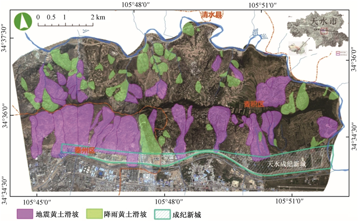
摘要: 本文通过天水市北山野外调查和室内分析相结合的方法,开展基于Newmark累积位移法的地震黄土滑坡危险性分析。分析了研究区的孕灾背景,结合现有滑坡和不稳定斜坡的调查数据,在充分考虑了震源方位角和斜坡坡向角的角度关系基础上,对优势坡向角和劣势坡向角下的斜坡易发性进行分析计算,然后用回归方程求出PGA为0.3 g时斜坡的累积位移,最后计算出斜坡在地震荷载下的失稳概率。在此基础上,对北山进行地震黄土滑坡的危险性评价。分析结果表明:在Newmark模型的地震黄土滑坡危险性评估中引入斜坡坡向角和震源方位角关系,有利于提高小区域(大比例尺)风险评估的准确性。Abstract: Based on the method of field investigation and indoor analysis of Beishan in Tianshui City, Gansu Procince, the analysis of the hazard analysis of the seismic loess landslide is carried out in this article based on the Newmark accumulated displacement method. Through analyzing the disaster-forming environment, combining with the investigation data of the existing landslides and unstable slopes, in fully consideration of the angle relationship between the azimuth angle of the source and the slope angle of the area, the calculation and comparison of the slope prone angle under the dominant slope angle and the inferior slope angle are carried out.Then the accumulation of slope displacementis calculateby using the regression equation when the PGA is 0.3g. Finally, the probability of instability of slope under earthquake load is calculated. On this basis, the risk assessment of the Seismic loess landslide of Beishan area was carried out. The analysis results show that introducing the relationship between the slope angle and the azimuth of seismic source in the risk assessment of the Loess Landslide in the Newmark model is helpful to improve the accuracy of the risk assessment of the small area (large scale).
-
Key words:
- Beishan of Tianshui City /
- seismic loess landslide /
- risk assessment /
- Newmark model
-
表 1 北山岩土体物理力学参数取值表
Table 1. Physical and mechanical parameters of rock and soil in Beishan
岩组 坚硬
(变质岩)较坚硬
(砂砾岩)较软(松散
沉积物,
藉河,
红旗山)软弱(松散
堆积物,距河
流较近,
锻压厂)φ′/° 40 35 24.5 22.2 c′/Pa 220000 140000 90400 59500 γ/(N·m -3) 24500 23000 17800 17500 表 2 累积位移Dn的Weibull函数拟合参数表
Table 2. The table of Weibull function fitting parameter of cumulative displacement
Dn P(Dn) 0.005 0.0891 0.05 0.0936 0.5 0.1566 1.5 0.1720 2.0 0.1921 -
[1] Newmark N M. Effects of earthquakes on dams and embankments[J]. Géotechnique, 1965, 15(2): 139~160. doi: 10.1680/geot.1965.15.2.139 [2] Wilson RC, Keefer D K. Dynamic analysis of a slope failure fromthe 6 August 1979 Coyote Lake, California, earthquake[J]. Bulletinof the Seismological Society of America, 1983, 73(3): 863~877. [3] Wilson RC, Keefer D K. Predicting areal limits of earthquakeinduced landsliding[J]. Geological Survey Professional Paper, 1985, 1360: 317~345. [4] Wieczorek G F, Wilson R C, Harp E L. Map showing slope stability during earthquakes in San Mateo County, California[J]. Annals of the New York Academy of Sciences, 1985, 681(6431): 155~64. https://pubs.er.usgs.gov/publication/i1257E [5] Jibson R W, Harp E L, Michael J A. A method for producing digital probabilistic seismic landslide hazard maps[J]. Engineering Geology, 2000, 58(3/4): 271~289. https://profile.usgs.gov/myscience/upload_folder/ci2009Apr221623134273769~Probability%20maps%20of%20Northridge,%20ENGEO%20small.pdf [6] Romeo R. Seismically induced landslide displacements: Apredictive model[J]. Engineering Geology, 2000, 58(3/4): 337~351. [7] Refice A, Capolongo D. Probabilistic modeling of uncertainties inearthquake-induced landslide hazard assessment[J]. Computers & Geosciences, 2002, 28(6): 735~749. [8] Godt J W, Sener B, Verdin K L, et al. Rapid assessment ofearthquake-induced landsliding[A]. Proceedings of the 1st World Landslide Forum[C]. Tokyo, Japan: Association for Disaster Prevention Research, 2008, 392~395. [9] 张春山, 何淑军, 辛鹏, 等.陕西省宝鸡市渭滨区地质灾害风险评价[J].地质通报, 2009, 28(8): 1053~1063. http://www.cnki.com.cn/Article/CJFDTOTAL-ZQYD200908008.htmZHANG Chun-shan, HE Shu-jun, XIN Peng, et al. Risk evaluation of geological hazards in Weibin District, Baoji City, Shaanxi Province, China[J]. Geological Bulletin of China, 2009, 28(8): 1053~1063. http://www.cnki.com.cn/Article/CJFDTOTAL-ZQYD200908008.htm [10] 李典庆, 吴帅兵.考虑时间效应的滑坡风险评估和管理[J].岩土力学, 2006, 27(12): 2239~2245, 2249. doi: 10.3969/j.issn.1000-7598.2006.12.029LI Dian-qing, WU Shuai-bing. Landslide risk assessment and management considering time effect[J]. Rock and Soil Mechanics, 2006, 27(12): 2239~2245, 2249. doi: 10.3969/j.issn.1000-7598.2006.12.029 [11] 乔建平, 王萌, 石莉莉.区域滑坡风险评估中的风险区划与概率分析[J].自然灾害学报, 2012, 21(2): 51~56. http://www.cnki.com.cn/Article/CJFDTOTAL-ZRZH201202006.htmQIAO Jian-ping, WANG Peng, SHI Li-li. Risk zoning and probability analysis of regional landslide risk assessment[J]. Journal of Natural Disasters, 2012, 21(2): 51~56. http://www.cnki.com.cn/Article/CJFDTOTAL-ZRZH201202006.htm [12] 王涛, 吴树仁, 石菊松, 等.基于简化Newmark位移模型的区域地震滑坡危险性快速评估——以汶川MS8.0级地震为例[J].工程地质学报, 2013, 21(1): 16~24.WANG Tao, WU Shu-ren, SHI Ju-song, et al. Case study on rapid assessment of regional seismic landslidehazard based on simplified Newmark displacementmodel: Wenchuan MS8.0 earthquake[J]. Journal of Engineering Geology, 2013, 21(1): 16~24. [13] 徐光兴, 姚令侃, 李朝红, 等.基于汶川地震强震动记录的边坡永久位移预测模型[J].岩土工程学报, 2012, 34(6): 1131~1136. http://www.cnki.com.cn/Article/CJFDTOTAL-YTGC201206027.htmXU Guang-xing, YAO Ling-kan, LI Chao-hong, et al. Predictive models for permanent displacement of slopes based on recordedstrong-motion data of Wenchuanearthquake[J]. Chinese Journal of Geotechnical Engineering, 2012, 34(6): 1131~1136. http://www.cnki.com.cn/Article/CJFDTOTAL-YTGC201206027.htm [14] 陈晓利, 袁仁茂, 庾露. Newmark方法在芦山地震诱发滑坡分布预测研究中的应用[J].地震地质, 2013, 35(3): 661~670. http://www.cnki.com.cn/Article/CJFDTOTAL-DZDZ201303019.htmCHEN Xiao-li, YUAN Ren-mao, YU Lu.Applying the Newmark's model to the assessmentof earthquake-triggered landslidesduring the Lushan earthquake[J]. Seismology and Geology, 2013, 35(3): 661~670. http://www.cnki.com.cn/Article/CJFDTOTAL-DZDZ201303019.htm [15] 雷中生, 袁道阳, 葛伟鹏, 等. 734年天水7级地震考证与发震构造分析[J].地震地质, 2007, 29(1): 51~62. http://www.cnki.com.cn/Article/CJFDTOTAL-DZDZ200701004.htmLEI Zhong-sheng, YUAN Dao-yang, GEWei-peng, et al. Textual research on the TianshuiM7 earthquakein 734 AD and analysisof its causative structure[J]. Seismology and Geology, 2007, 29(1): 51~62. http://www.cnki.com.cn/Article/CJFDTOTAL-DZDZ200701004.htm [16] 刘白云. 甘东南地区两次8级历史疑难地震发震构造与发震机制研究[D]. 兰州: 中国地震局兰州地震研究所, 2012.LIU Bai-yun. A study on causative structure and mechanism of two Ms8.0 earthquakes in the Southeast area of Gansu[D]. Lanzhou: Lanzhou Institute of Seismology, 2012. [17] 田尤, 杨为民, 黄晓, 等.天水市麦积区幅黄土滑坡发育分布特征及其孕灾因素分析[J].地质力学学报, 2016, 22(1): 25~38. http://journal.geomech.ac.cn/ch/reader/view_abstract.aspx?flag=1&file_no=20160103&journal_id=dzlxxbTIAN You, YANGWei-min, HUANG Xiao, et al. Distribution characteristics and inducing factors of loess landslide in MaijiMappable Unit, Tianshui[J]. Journal of Geomechanics, 2016, 22(1): 25~38. http://journal.geomech.ac.cn/ch/reader/view_abstract.aspx?flag=1&file_no=20160103&journal_id=dzlxxb [18] 中华人民共和国建设部. 岩土工程勘察规范(GB 50021~2001)[S]. 北京: 中国建筑工业出版社, 2002.Minstry of construction of the People's Republic of China. Specifications of geotechnical engineering investigation (GB 50021~2001)[S]. Beijing: China building industry Press, 2002. [19] 葛华, 陈启国, 王德伟.地震滑坡危险性评价及编图——以映秀震中区为例[J].中国地质, 2013, 40(2): 644~652. http://www.cnki.com.cn/Article/CJFDTOTAL-DIZI201302029.htmGE Hua, CHEN Qi-guo, WANG De-wei.The assessment and mapping of seismic landslide hazards: A case study ofYingxiu area, Sichuan Province[J]. Geology in China, 2013, 40(2): 644~652. http://www.cnki.com.cn/Article/CJFDTOTAL-DIZI201302029.htm -


 下载:
下载:


