APPLICATION OF ASTER-GDEM DATA IN THE GEOMORPHIC CHARACTERISTICS ANALYSIS OF NORTHERN GREAT HIGGNAN LING MOUNTAINS
-
摘要: 基于ASTER-GDEM数据,利用彩色晕染、密度分割与GIS空间统计分析技术,结合地质资料,通过地形高程(平均高程、最大高程和最小高程)、地势起伏度、典型高程剖面及流域面积-高程积分等手段,对大兴安岭北段的地貌特征进行初步分析。分析结果表明,研究区主体呈现平原(台地)与丘陵地貌,地势相对平缓,呈北北东向延伸展布,存在多期隆升,受到北北东向区域构造控制,且遭受北西向构造活动改造;高程剖面揭示研究区存在多级剥夷面(或面状地貌面),最多可划分5级,且在各段、各坡向上发育特征不一,北北东向构造对地貌演化的控制作用强于近东西向构造,其活动强度上北段明显强于中、南段;面积-高程积分分析表明研究区地貌演化处于壮年期的晚期,山体处于隆升晚期或趋于稳定阶段,但北西向构造活动,形成大量狭长的新生沟谷。
-
关键词:
- ASTER-GDEM /
- 流域面积-高程积分 /
- 构造地貌 /
- 大兴安岭北段
Abstract: Based on ASTER-GDEM (30 m) data and geological information, adopting color-dye, density-class and GIS spatial analysis technology, the authors studied geomorphic characteristics of the northern Great Higgnan Ling Mountains by means of topography-elevation analysis, terrain-section analysis and hypsometric integral. According to the research results, the topographies of the present plain (plateau) and hills in the NNE-trending northern Great Higgnan Ling Mountains are the direct result of multi-stage uplifting. The range is strictly controlled by the NNE-trending regional faults activity, and then affected by the NW-trending faults activity. The northern Great Higgnan Ling Mountains have developed 5-level denudation-planation surfaces with different elevation, whose characteristics are different in the each area due to different erosion and tectonic activity. The NNE-trending faults activity is more obvious in the northern. The research of Hypsometric integral curve significantly suggests the late mature period of geomorphic evolution in the northern Great Higgnan Ling Mountains, because of tectonic uplift tending to stability stage, and a large number of long and narrow NW-trending valleys formed for the response of the NW-trending faults activity.-
Key words:
- ASTER-GDEM /
- hypsometric integral /
- northern Great Higgnan Ling Mountains /
- geomorphology
-
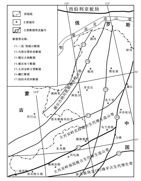
图 1 大兴安岭北段大地构造简图
(根据文献[14]略改)
Figure 1. Tectonic sketch of the northern Great Higgnan Ling Mountains
表 1 大兴安岭北段高程统计
Table 1. Height statistics of the northern Great Higgnan Ling Mountains

表 2 大兴安岭北段地势起伏度统计
Table 2. Amplitude statistics of the northern Great Higgnan Ling Mountains

-
[1] 洪顺英, 申旭辉, 荆凤, 等.基于SRTM-DEM的阿尔泰山构造地貌特征分析[J].国土资源遥感, 2007, 73(3):62~66. doi: 10.6046/gtzyyg.2007.03.14HONG Shun-ying, SHEN Xu-hui, JING Feng, et al. An analysis of geomorphology characteristics of the Altai Mountain based on DEM[J]. Remote Sensing for Land and Resources, 2007, (3):62~66. doi: 10.6046/gtzyyg.2007.03.14 [2] Michael A. Geomorphology and global tectonics[M]. London:John Wiley &Sons, Ltd. Press, 2000:1~367. [3] 陈彦光, 刘继生.地理学主要任务与研究方法[J].地理科学, 2004, 24(3):257~262. http://www.cnki.com.cn/Article/CJFDTOTAL-DLKX200403001.htmCHEN Yan-guang, LIU Ji-sheng. Main Tasks and Methods of Geography[J]. Scientia Geographica Sinca, 2004, 24(3):257~262. http://www.cnki.com.cn/Article/CJFDTOTAL-DLKX200403001.htm [4] 张会平, 杨农, 张岳桥, 等.基于DEM的岷山构造带构造地貌初步研究[J].国土资源遥感, 2004, 16(4):54~58. doi: 10.6046/gtzyyg.2004.04.14ZHANG Hui-ping, YANG Nong, ZHANG Yue-qiao, et al. A GIS-based research on morpho-structural features of the Minshan tectonic belt[J]. Remote Sensing for Land & Resources. 2004, 16(4):54~58. doi: 10.6046/gtzyyg.2004.04.14 [5] 梅安新, 彭望琭, 秦其明, 等.遥感导论[M].北京:高等教育出版社, 2001.MEI An-xin, PENG Wang-lu, QIN Qi-ming, et al. Introduction to remote sensing[M]. Beijing:Higher Education Press, 2001. [6] 闾国年, 钱亚东, 陈钟明.基于栅格数字高程模型提取特征地貌技术研究[J].地理学报, 1998, 53(6):562~569. http://www.cnki.com.cn/Article/CJFDTOTAL-DLXB806.009.htmLÜ Guo-nian, QIAN Ya-dong, CHEN Zhong-ming. Automated extraction of the characteristics of topography from grid digital elevation data[J]. Acta Geographica Sinica, 1998, 53(6):562~569. http://www.cnki.com.cn/Article/CJFDTOTAL-DLXB806.009.htm [7] 王义祥, 刘勇, 潘保田.夷平面数字地形模型的生成、显示与分析初探:以美武高原为例[J].遥感技术与应用, 1999, 14:59~64. doi: 10.11873/j.issn.1004-0323.1999.4.59WANG Yi-xiang, LIU Yong, PAN Bao-tian. A preliminary approach on the generation, display and analysis of digital terrain model of planation surface:Taking Meiwu Plateau as an example[J]. Remote Sensing Technology and Application, 1999, 14:59~64. doi: 10.11873/j.issn.1004-0323.1999.4.59 [8] 胡世雄, 王珂.现代地貌学的发展与思考[J].地学前缘, 2000, (7):67~78. http://www.cnki.com.cn/Article/CJFDTOTAL-DXQY2000S2011.htmHU Shi-xiong, WANG Ke. Development and tendency of modern geomorphology[J]. Earth Science Frontiers, 2000, (7):67~78. http://www.cnki.com.cn/Article/CJFDTOTAL-DXQY2000S2011.htm [9] 钱程, 韩建恩, 朱大岗, 等.基于ASTER-GDEM数据的黄河源地区构造地貌分析[J].中国地质, 2012, 39(5):1247~1250. http://www.cnki.com.cn/Article/CJFDTOTAL-DIZI201205011.htmQIAN Cheng, HANJian-en, ZHU Da-gang, et al. An analysis of geomorphology characteristics of the Yellow River source region based on ASTER-GDEM[J]. Geology in China, 2012, 39(5):1247~1250. http://www.cnki.com.cn/Article/CJFDTOTAL-DIZI201205011.htm [10] 赵洪壮, 李有利, 杨景春, 等.基于DEM数据的北天山地貌形态分析[J].地理科学, 2009, 29(3):445~449. http://www.cnki.com.cn/Article/CJFDTOTAL-DLKX200903023.htmZHAO Hong-zhuang, LI You-li, YANG Jing-chun, et al. Geomorphic characteristics of North Tianshan Mountain based on DEM data[J]. Scientia Geographic Sinica, 2009, 29(3):445~449. http://www.cnki.com.cn/Article/CJFDTOTAL-DLKX200903023.htm [11] Fielding E J, Isachs B, Barazangi M, et al. How flat is Tibet[J]. Geology, 1994, (22):163~167. [12] 高力.利用数字高程模型生成地形三维仿真图[J].西安工程学院学报, 2000, 22(3):59~62. http://www.cnki.com.cn/Article/CJFDTOTAL-XAGX200003014.htmGAO Li. Creating 3Dterrain-realistic graphics by digital elevation model[J]. Journal of Xi'an Engineering University, 2000, 22(3):59~62. http://www.cnki.com.cn/Article/CJFDTOTAL-XAGX200003014.htm [13] 张克歧, 杨国东, 杨化超.三维地面模型的可视化研究[J].东北测绘, 2002, 25(2):9~10. http://www.cnki.com.cn/Article/CJFDTOTAL-SJDZ200104018.htmZHANG Ke-qi, YANG Guo-dong, YANG Hua-chao. Reseanch on visualization of three dimensional terrain model[J]. Northeast Surveying and Mapping, 2002, 25(2):9~10. http://www.cnki.com.cn/Article/CJFDTOTAL-SJDZ200104018.htm [14] 刘建明, 张锐, 张庆洲.大兴安岭地区的区域成矿特征[J].地学前缘, 2004, 11(1):269~277. http://www.cnki.com.cn/Article/CJFDTOTAL-DXQY200401036.htmLIU Jian-ming, ZHANG Rui, ZHANG Qing-zhou. The regional metallogeny of Da Hinggan Ling, China[J]. Earth Science Frontiers, 2004, 11(1):269~277. http://www.cnki.com.cn/Article/CJFDTOTAL-DXQY200401036.htm [15] 内蒙古自治区地质矿产局.内蒙古自治区区域地质志[M].北京:地质出版社, 1991.Bureau of Geology and Mineral Resources of Nei Mongal Autonomous Region. Regional geology of Nei Mongal Autonomous Region[J]. Beijing:Geological Publishing House, 1991. [16] 李锦轶, 莫申国, 和政军, 等.大兴安岭北段地壳左行走滑运动的时代及其对中国东北及邻区中生代以来地壳构造演化重建的制约[J].地学前缘, 2004, 11(3):157~168. http://www.cnki.com.cn/Article/CJFDTOTAL-DXQY200403022.htmLI Jin-yi, MO Shen-guo, HE Zheng-jun, et al. The timing of crustal siniatral strike-slip movement in the northern Great Khing'an Ranges and its constraint on reconstruction of the crustal tectonic evolution of NE China and adjacent areas since the Mesozonic[J]. Earth Science Frontiers, 2004, 11(3):157~168. http://www.cnki.com.cn/Article/CJFDTOTAL-DXQY200403022.htm [17] 李锦轶, 张进, 杨天南, 等.北亚造山区南部及其毗邻地区地壳构造分区与构造演化[J].吉林大学学报:地球科学版, 2009, 39(4):584~605. http://www.cnki.com.cn/Article/CJFDTOTAL-CCDZ200904002.htmLI Jin-yi, ZHANG Jin, YANG Tian-nan, et al. Crustal tectonic division and evolution of the southern part of the North Asian orogenic region and its adjacent areas[J]. Journal of Jilin University:Earth Science Edition, 2009, 39(4):584~605. http://www.cnki.com.cn/Article/CJFDTOTAL-CCDZ200904002.htm [18] Strahler A N. Hypsometric (area-altitude) analysis of erosional topography[J]. Bulletin of the Geological Society of America, 1952, 63:1117~1142. doi: 10.1130/0016-7606(1952)63[1117:HAAOET]2.0.CO;2 [19] Pike R J, Wilson S E. Elevation-relief ratio, hypsometric integral and geomorphic area-altitude analysis[J]. Bulletin of the Geological Society of America, 1971, 62:1079~1084. [20] 尹国康.流域地貌系统[M].南京:南京大学出版社, 1991:210~212.YIN Guo-kang. Watershed geomorphology system[M]. Nanjing:Nanjing University Press, 1991:210~212. [21] 陈彦桀, 郑光佑.面积尺度与空间分布对流域高度积分及地质意义影响[J].地理学报(台湾), 2005, 39:53~69.CHEN Yan-jie, ZHENG Guang-you. The spatial distribution of dimension and height of the basin and the geological significance influence. Integration[J]. Geographical Journal (Taiwan):2005, 39:53~69. -


 下载:
下载:


