

CHARACTERISTICS OF SEISMIC ACTIVITY AND SEISMIC RISK PROBLEMS IN THE CENTRAL-EASTERN YANGTZE RIVER ECONOMIC BELT (SHANGHAI-CHONGQING SECTION)
-
摘要: 基于历史和仪器地震资料,重点介绍了长江经济带东段地震活动特点,进行了地震区带划分,探讨了该区中心城市的震灾问题,并结合区域地震异常,指出了当前华东沿海和郯庐带南段的地震危险性信息,指出了本区面临的地震安全和防震减灾的问题及相关建议。Abstract: In this paper, based on historical and instrumental seismic data, we focused on the characteristics of the seismic activity in the eastern part of Yangtze River Economic Belt, gave the division of seismic zone, discussed the problems of the earthquake in the city center area. Combining with regional seismic anomaly, we pointed out the great earthquake hazard information of the current eastern coastal and Tanlu belt, pointed out the problems and related suggestions on confronting the earthquake safety and earthquake prevention and disaster reduction.
-


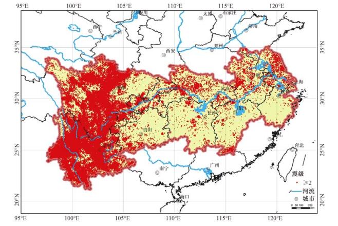
图 2 长江经济带(重庆—上海)地震活动分布图(M≥2.0)[3]
Figure 2. The seismic activity distribution map of the Yangtze River Economic Belt (Chongqing-Shanghai) (M≥2.0)


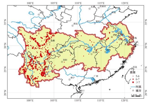
图 4 长江经济带历史地震烈度[8]
Figure 4. The historical earthquake intensity in the Yangtze River Economic Belt

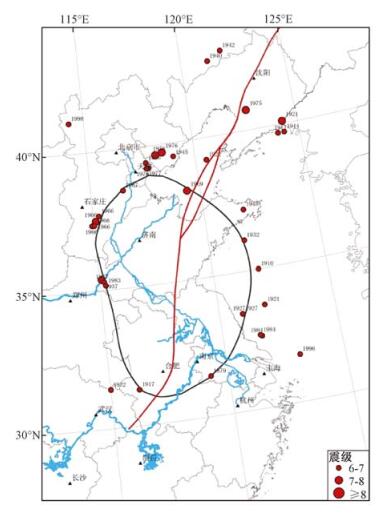
图 5 1910—2015华东地区地震(M≥6.0) 空区图
Figure 5. A map showing the seismic gap (M≥6.0) in East China in 1910—2015

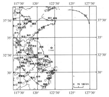
图 6 1846年8月4日南黄海地震烈度图[9]
Figure 6. The seismic intensity map in the South Yellow Sea on August 4, 1846

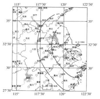
图 7 1984年5月21日南黄海地震烈度图[9]
Figure 7. The seismic intensity map in the South Yellow Sea on May 21, 1984
-
[1] 观察者网. 2014年各省GDP排名台湾险被河北超越9省人均破1万美元[EB/OL]. [2016-03-15]. http://www.guancha.cn/economy/2015_02_03_308419.shtml.The Observer Network. 2014 GDP ranking of the provinces of Taiwan, Hebei insurance is more than 9 provinces in excess of 10 thousand dollars per capita[EB/OL].[2016-03-15]. http://www.guancha.cn/economy/2015_02_03_308419.shtml. [2] 中国人口密度图[EB/OL]. [2016-03-15]. http://www.eku.cc/xzy/sctx/121867.htm.The population density map of China[EB/OL].[2016-03-15]. http://www.eku.cc/xzy/sctx/121867.htm. [3] 中国地震信息网. 全国2级以上地震[EB/OL]. [2016-03-15]. http://www.csi.ac.cn/publish/main/813/5/index.html.China Earthquake Information Network. The earthquakes with magnitude being more than 2 in China[EB/OL].[2016-03-15].http://www.csi.ac.cn/publish/main/813/5/index.html. [4] 国家地震局地球物理研究所, 复旦大学历史地理研究所.中国历史地震图集(明)[M].北京:中国地图出版社, 1986Geophysics Research Institute of State Seismological Bureau, The Historical Geography Research Institute of Fudan University. Atlas of the historical earthquakes in China (Ming)[M]. Beijing:China Cartographic Publishing House, 1986. [5] 国家地震局地球物理研究所, 复旦大学历史地理研究所.中国历史地震图集(清)[M].北京:中国地图出版社, 1986Geophysics Research Institute of State Seismological Bureau, the Historical Geography Research Institute of Fudan University. Atlas of the historical earthquakes in China (Qing)[M]. Beijing:China Cartographic Publishing House, 1986. [6] 顾功叙.中国地震目录(公元1970-1979年)[M].北京:地震出版社, 1984GU Gong-xu. China seismological catalogue (1970-1979)[M]. Beijing:Seismological Press, 1984. [7] 中国地震局.中国历史强震目录[M].北京:地震出版社, 1995China Earthquake Administration. Chinese historical strong earthquake catalog[M]. Beijing:Seismological Press, 1995. [8] 中国地震信息网. 中国地震综合等震线图[EB/OL]. [2016-03-15]. http://www.csi.ac.cn/publish/main/837/1074/index.html.China Earthquake Information Network. Chinese comprehensive earthquake isoseismal map[EB/OL].[2016-03-15]. http://www.csi.ac.cn/publish/main/837/1074/index.html. [9] 刘昌森, 于海英, 王锋, 等.长江三角洲自然灾害录[M].上海:同济大学出版社, 2015LIU Chang-sen, YU Hai-ying, WANG Feng, et al. Catalogue of natural disasters in the Yangtze River Delta[M]. Shanghai:Tongji University Press, 2015. -

 下载:
下载:


计量
- 文章访问数: 620
- HTML全文浏览量: 544
- PDF下载量: 35
- 被引次数: 0
