APPLICATION OF UNMANNED AIR VEHICLE (UAV) REMOTE SENSING DATA IN THE RECOGNITION OF STRATIGRAPHIC UNITS: A CASE STUDY OF 1: 50000 PILOT GEOLOGICAL MAPPING OF KARST AREA IN SOUTHWESTERN CHINA
-
摘要: 不同基岩组合形成的微地貌形态特征的获取是大比例尺遥感解译岩石地层单元的基础,关键是提高遥感影像及地形数据的空间分辨率。在西南岩溶区填图试点项目中,通过无人机航空遥感平台(UAV)获取了工作区0.2 m分辨率的高精度遥感影像、高密度的点云数据以及0.5 m分辨率的数字高程模型(DEM),影像与DEM叠加建立工作区三维地表模型,实现了区内微地貌形态的高清晰度真三维再现,真实客观地描述了区域地表微地貌特征,促进了不同基岩上形成的微地貌特征的精细化研究,提高了遥感数据的解译程度。解译过程中结合已有地质资料,建立工作区不同岩石地层单元的微地貌、颜色及植被等方面的解译标志,基于三维地表模型实现了对工作区岩石地层单元的识别。Abstract: As microgeomorphologic characteristics formed by different units are the basis of the large scale interpretation remote sensing of lithostratigraphic units, it is very important to increase the resolution of remote sensing images and terrain data. During proceeding the project of the 1:50000 mapping pilot of karst area of southwest China, we use the Unmanned Aerial Vehicle (UAV) platform to obtain high resolution images (0.2 m), high density point cloud data and 0.5 m resolution DEM data of our working area. According to these data, it is easy to describe the microgeomorphologic characteristics of surface objectively by reproducing the high definition real 3D model of microgeomorphology in the working area, to advance the precise researches of microgeomorphologic characteristics of different kind rocks and to improve the interpretation degree of remote sensing data. Combing the existing geological data, interpretation indexes of different microreliefs, colors and vegetation of different stratigraphic unit are set up based on the surface 3D model.
-
Key words:
- UAV /
- remote Sensing /
- DEM /
- surface 3D Model /
- microgeomorphology /
- lithostratigraphic unit
-
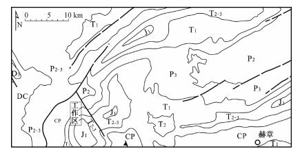
图 1 工作区位置及地质构造简图[10](虚线框为无人机航拍工作区)
Figure 1. Location and regional geological map of the study area
表 1 无人机航测性能指标
Table 1. UAV system performance index
无人机型号 自动驾驶仪 飞行器巡航速度/
(km·h-1)数据采集仪 飞行相对
高度/m航线重叠度/% 飞行海拔
高度/m地面平均
分辨率/m航向 旁向 FREE BIRD
电动无人机AF2012 60 理光GXR
A12-28MM800 80 60 2800 0.2 表 2 工作区地层岩石单元解译特征
Table 2. Interpretation characteristics of lithostratigraphic units in the study area
岩石地层单元 岩性特征 岩石组合 地形地貌特征 须家河组
(T3x)灰黄绿、灰色岩屑长石石英砂岩 砂岩岩组 易受风化剥蚀, 表层形成风化土层, 植被发育茂密, 地貌圆缓, 局部形成陡崖, 同灰岩白岩岩接触位置宜形成陡坎陡崖 关岭组
(T2g)深灰、灰色薄至厚层泥晶灰岩夹黏土岩 粉砂岩-碳酸盐岩互层岩组 下部差异风化形成阶梯状地形; 上部厚层灰岩形成岩溶残丘地貌, 山顶呈半圆浑状, 延展较好, 植被稀疏 灰、黄灰色中厚层泥质白云岩、白云岩 深灰、黄绿、灰绿夹紫红色黏土岩 灰色薄至厚层块状白云岩夹黏土岩 嘉陵江组
(T1-2j)灰色中厚层白云岩 粉砂岩-碳酸盐岩互层岩组 下部同上部为厚层状灰岩白云岩, 形成陡崖, 岩溶峡谷地貌, 中部差异风化形成阶梯状地形, 植被较为稀疏 灰色中厚层泥晶灰岩夹泥质灰岩、黏土岩 灰色薄至厚层白云岩夹杂色黏土岩 灰色薄至厚层泥晶灰岩 飞仙关组
(T1f)紫红夹灰绿色薄至厚层粉砂岩、岩屑砂岩、细砂岩, 夹薄层泥晶灰岩 砂岩岩组 剥蚀地貌, 发育陡坡, 单侧呈羽状分布, 山顶为尖棱状, 以折线为主, 延展较好, 以大面积紫红色出露为特征, 植被较为茂密 宣威组
(P3x)砂岩、粉砂岩和页岩, 夹细砂岩和煤层 粉砂岩岩组 剥蚀地貌, 风化较为严重, 形成缓坡, 上部煤层以灰色、灰黑色斑块状为特征, 植被发育较好 峨眉山玄武岩
(P3β)拉斑玄武岩夹凝灰岩, 顶部为紫红色浆屑凝灰岩 火山岩岩组 风化较为严重, 形成缓坡地貌, 局部形成陡崖, 顶部紫红色凝灰岩, 植被较为稀疏 茅口组
(P2m)灰色厚层块状含生物屑微晶至泥晶灰岩, 生物(蜓)灰岩, 燧石条带灰岩 碳酸盐岩岩组 发育岩溶残丘, 岩溶峡谷地貌, 植被较稀疏 栖霞组
(P2q)灰色厚层块状夹中厚层微晶至泥晶生物屑灰岩 碳酸盐岩岩组 发育岩溶残丘, 岩溶峡谷地貌, 植被较稀疏 -
[1] 毕坤, 盛学庸, 董存忠.航空相片在区域岩溶地貌研究中的应用[J].中国岩溶, 1986, (1):118~124, 163~164.BI Kun, SHENG Xue-yong, DONG Cun-zhong. The application of erial images to the study of the regional karst landforms[J]. Carsologica Sinica, 1986, (1):118~124, 163~164. [2] 韩文权, 任幼蓉, 赵少华.无人机遥感在应对地质灾害中的主要应用[J].地理空间信息, 2011, 9(5):6~8, 163. http://www.cnki.com.cn/Article/CJFDTOTAL-DXKJ201105004.htmHAN Wen-quan, REN You-rong, ZHAO Shao-hua. Primary usages of UAV remote sensing in geological disaster monitoring and rescuing[J]. Geospatial Information, 2011, 9(5):6~8, 163. http://www.cnki.com.cn/Article/CJFDTOTAL-DXKJ201105004.htm [3] 田莉.地质遥感中岩性的识别研究[J].科技传播, 2010, 19:220, 223. http://www.cnki.com.cn/Article/CJFDTOTAL-KJCB201019200.htmTIAN Li. Research on geological remote sensing lithologic identification[J]. Public Communication of Science & Technology, 2010, 19:220, 223. http://www.cnki.com.cn/Article/CJFDTOTAL-KJCB201019200.htm [4] 张克信, 孙赜, 于庆文, 等.基于数字填图系统的遥感等数据在基于数字填图系统的遥感等数据在构造-地层分区和地层单位识别中应用——以1:25万民和县幅、临夏市幅和定西市幅数字地质填图为例[J].地质通报, 2008, 27(7):965~973. http://www.cnki.com.cn/Article/CJFDTOTAL-ZQYD200807006.htmZHANG Ke-xin, SUN Ze, YU Qing-wen, et al. Application of remote sensing data to the tectono-stratigraphic division and recognition of stratigraphic units based on the digital mapping system:A case study of 1:250000 digital geological mapping of the Minhe County, Linxia City and Dingxi City she[J]. Geological Bulletin of China, 2008, 27(7):965~973. http://www.cnki.com.cn/Article/CJFDTOTAL-ZQYD200807006.htm [5] 邹长慧, 谢晓尧, 周忠发.无人机低空航拍遥感系统在贵州高原山区的应用前景探讨[J].贵州师范大学学报:自然科学版, 2011, 29(2):24~28. http://www.cnki.com.cn/Article/CJFDTOTAL-NATR201102008.htmZOU Chang-hui, XIE Xiao-yao, ZHOU Zhong-fa. Future prospects in utilization of photo-taking unmanned aerial vehicle in low altitude of RS system in plateau mountain area of Guizhou[J]. Journal of Guizhou Normal University:Natural Sciences, 2011, 29(2):24~28. http://www.cnki.com.cn/Article/CJFDTOTAL-NATR201102008.htm [6] 刘静, 陈涛, 张培震, 等.机载雷达扫描揭示海原断裂带微地貌的精细结构[J].科学通报, 2013, 58:41~45. http://www.cnki.com.cn/Article/CJFDTOTAL-KXTB201301003.htmLIU Jing, CHEN Tao, ZHANG Pei-zhen, et al. Illuminating the active Haiyuan fault, China by Airborne Light Detection and Ranging[J]. Chinese Science Bulletin, 2013, 58:41~45. http://www.cnki.com.cn/Article/CJFDTOTAL-KXTB201301003.htm [7] David Riao, Emilio Chuvieco, Javier Salas, et al. Assessment of different topographic corrections in Landsat-TM data for mapping vegetation types[J]. IEEE Transactions on Geoscience and Remote Sensing, 2003, 41(5):1056~1061. doi: 10.1109/TGRS.2003.811693 [8] Jenson S K, Domingue J O. Extracting topographic structure from digital elevation data for geographic information system analysis[J]. Photogrammetric Engineering and Remote Sensing, 1988, 54(11):1593~1600. [9] Ricchetti E. Visible-infrared and radar imagery fusion for geological application:A new approach using DEM and sun-illumination model[J]. International Journal of Remote Sensing, 2001, 22(11):2219~2230. [10] 中国地质调查局. 1:250万中国地质图[M].北京:中国地图出版社, 2004.China Geological Survey. Geological map of China (1:2500000)[M]. Beijing:China Map Publishing House, 2004. -


 下载:
下载:


