

CHARACTERISTICS OF THE FRACTURES IN YANGKOU AREA, RUDONG, JIANGSU PROVINCE AND ITS IMPLICATION
-
摘要: 结合已有地热钻孔采用多种物探方法研究了江苏如东洋口地区断裂的空间展布特征。研究结果表明,洋口地区分布3组断裂,分别为隶属滨海断裂的北西向雁行型次级断裂、近东西向栟茶河断裂及海安-河口断裂。北西向雁行型次级断裂为4条,主要分布于洋口地区北段及老坝港地区,断裂陡倾,倾向北东,倾角70°-80°,推测切穿至新近系。栟茶河断裂由3条次级断裂组成,主要分布于洋口地区中段,断裂走向近东西,倾向北,整体呈曲折状延伸,倾角60°-80°。结合以往地震地质特征以及地热钻孔资料,认为栟茶河断裂为活动性断裂,切穿了第四纪全新世地层,全新世地层断距较小。断裂的活动性影响如东洋口经济开发区的建设与发展。海安-河口断裂自海安延伸至洋口地区南段,走向近东西,倾向南,倾角约为70°,切穿古近纪地层。洋口地区断裂的分布与该地区地热资源分布具有良好的对应关系,其对于该地区地热资源开发具有良好的指导意义。Abstract: Fracture characteristics in Rudong Yangkou area, Jiangsu province have been studied through various geophysical methods combined with geothermal drilling data in this paper. Results indicate that there are three fault systems in Yangkou area, including a NW-trending secondary fault system of Binhai fault, EW-trending Benchahe fault system and Haian-Hekou fault. The NW-trending secondary fault system contains four secondary faults, mainly distributed in the north of Yangkou area and Laobagang area. The faults are steeply NE-dipping, with dip angles range from 70° to 80°, and speculatively cut through the Neogene strata. The EW-trending Benchahe fault system contains three secondary faults, mainly distributed in the middle of Yangkou area. The faults are mainly north dipping, with dip angles range from 60° to 80°. Combined with previous seismogeological and geothermal data in Yangkou area, it is comprehensively speculated that Benchahe fault is active, which makes the Quaternary Holocene strata being cut off with minor displacement. The activity of Benchahe fault influences the safety in the construction and development of Yangkou Economic area. The EW-trending Haian-Hekou fault is south dipping with the dip angle about 70°, extending from haian to the south of Yangkou area and cut off the Paleogene strata. There is compatible corresponding relation between distribution characteristics of faults and geothermal resources in Yangkou area, which is of certain guiding significance for the geothermal resources exploitation in this region.
-
Key words:
- fracture characteristics /
- binhai fault /
- benchahe fault /
- geothermal resource /
- Yangkou area
-

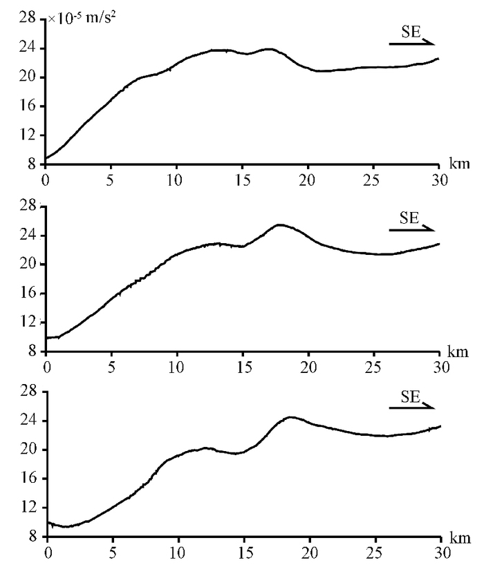
图 3 L1—L3线布格重力异常曲线
Figure 3. Bouguer gravity anomaly curves along L1, L2 and L3 Lines in Yangkou area

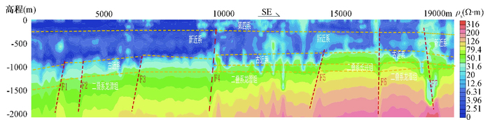
图 4 B4反演电阻率推断解释剖面
Figure 4. Inversion resistivity and geological interpretation of Line B4

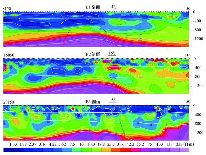
图 5 B1—B3反演电阻率推断解释剖面
Figure 5. Inversion resistivity and geological interpretation of B1, B2 and B3 profiles
表 1 地层密度分层表
Table 1. Hierarchical table of formation density in Yangkou area
密度层 平均密度值/(103 kg·m-3) 地质属性 第一密度层 1.99 第四系 第二密度层 2.28 新近系、古近系 第三密度层 2.58 白垩系、侏罗系及中、上三叠统 第四密度层 2.71 下三叠统—中元古界  下载: 导出CSV
-
[1] 邓起东.城市活动断裂探测和地震危险性评价问题[J].地震地质, 2002, 24(4):601~605. http://www.cnki.com.cn/Article/CJFDTOTAL-DZDZ200204015.htmDENG Qi-dong. Exploration and seismic hazard assessment of active faults in urban areas[J]. Seismology and Geology, 2002, 24(4):601~605. http://www.cnki.com.cn/Article/CJFDTOTAL-DZDZ200204015.htm [2] 范迪富, 徐雪球, 戴康明.江苏如东县小洋口地热田成因研究[J].地质学刊, 2012, 36(2):192~197. http://www.cnki.com.cn/Article/CJFDTOTAL-JSDZ201202018.htmFAN Di-fu, XU Xue-qiu, DAI Kang-ming. Origin study of geothermal field in Xiaoyangkou of Rudong County in Jiangsu[J]. Journal of Geology, 2012, 36(2):192~197. http://www.cnki.com.cn/Article/CJFDTOTAL-JSDZ201202018.htm [3] 左丽琼, 王彩会, 荆慧, 等.综合物探方法在南通小洋口地区地热勘查中的应用[J].工程地球物理学报, 2016, 13(1):122~129. http://www.cnki.com.cn/Article/CJFDTOTAL-GCDQ201601023.htmZUO li-qiong, WANG Cai-hui, JING Hui, et al. The application of comprehensive geophysical prospecting method to geothermal prospecting in Xiaoyangkou of Nantong City in Jiangsu[J]. Chinese Journal of Engineering Geophysics, 2016, 13(1):122~129. http://www.cnki.com.cn/Article/CJFDTOTAL-GCDQ201601023.htm [4] 范迪富, 徐宁玲.苏北盆地中低温地热资源成矿模式研究[J].水文地质工程地质, 2015, 42(4):164~170. http://www.cnki.com.cn/Article/CJFDTOTAL-SWDG201504029.htmFAN Di-fu, XU Ning-ling. A study of the occurrence of geothermal resources of low to medium temperature in the Subei Basin[J]. Hydrogeology and Engineering Geology, 2015, 42(4):164~170. http://www.cnki.com.cn/Article/CJFDTOTAL-SWDG201504029.htm [5] 张登明, 徐雪球, 陈火根, 等. 1: 25万南通市幅区域地质调查报告[R]. 南京: 江苏省地质调查研究院, 2003. http://www.wenkuxiazai.com/doc/4b7e0a700b1c59eef8c7b462.htmlZHANG deng-ming, XU Xue-qiu, CHEN Huo-gen, et al. The 1:250000 regional geological survey report of the People's Republic of China, Nantongshi photograph(I51C004001)[R]. Nanjing:Geological Survey of Jiangsu Province, 2003. http://www.wenkuxiazai.com/doc/4b7e0a700b1c59eef8c7b462.html [6] 刘宪光, 程知言, 杨晋炜, 等. 江苏省1: 5万三仓镇、弶港镇、李堡镇、栟茶镇、岔河镇、白蒲镇幅区域地质调查报告[R]. 南京: 华东有色海洋院, 2016.LIU Xian-guang, CHENG Zhi-yan, YANG Jin-wei, et al. The 1:50000 regional geological survey report of the People's Republic of China, Sancangzhen photograph (I51E020003), Jianggangzhen photograph (I51E020004), Libaozhen photograph (I51E021003), Benchazhen photograph (I51E021004), Chahezhen photograph (I51E022004), Baipuzhen photograph (I51E023004)[R]. Nanjing:Institute of Geochemical Exploration and Marine Geological Survey, ECE, 2016. [7] 王明义, 郝培栋, 郭永春, 等. 江苏省苏中工区1/5万重力测量成果报告[R]. 南京: 地矿部华东石油局第6物探大队, 1991.WANG Ming-yi, HAO Pei-dong, GUO Yong-chun, et al. The 1:50000 gravity survey report of central Jiangsu region[R]. Nanjing:The No.6 Geophysical Prospecting Unit of East China Petroleum Bureau, 1991. -

 下载:
下载:


计量
- 文章访问数: 292
- HTML全文浏览量: 131
- PDF下载量: 20
- 被引次数: 0
