

APPLICATION OF SPATIAL DATABASE TECHNOLOGY AND SEISMIC GAP METHOD TO SEISMIC HAZARD ANALYSIS AROUND SOUTH-EASTERN TIBETAN PLATEAU
-
摘要: 以ARCGIS系列软件和VS 2010、SQL Server 2008为平台, 通过融合集成活动构造、地震地质和国家基础地理信息, 在初步建立的青藏高原东南缘活动构造空间数据库系统基础上, 利用地震围空区方法, 针对研究区进行区域大地震危险性中长期预测分析。通过地震信息分时间、分震级的整理与数据输出, 分析汇总了11例M≥7.0大震震例的地震空区活动图像以及围空区发震震级与围空区特征与参数。在总结出的经验公式基础上, 进一步利用1950-2012年的M≥5.0地震数据, 对该区地震围空区的发生与发育状况进行了初步分析与研究, 并对未来可能发生大震的发震位置及震级进行了综合分析。研究结果表明, 玉树-鲜水河-小江断裂带所围限的青藏高原东南缘地区存在6个比较突出的与区域重要的晚第四纪活动构造带或断裂带相对应的大地震围空区, 分别是错那-沃卡裂谷, 东喜马拉雅构造结, 安宁河-则木河断裂, 南汀河断裂-红河断裂, 畹町断裂-南汀河断裂, 澜沧-景洪断裂东段。这些围空区中主要活动断裂带的晚第四纪活动性与历史地震活动状况也都显示出未来几年至几十年存在发生大地震的危险性, 在今后的地震预报工作中应给予特别关注。应用实践表明, 通过活动构造数据库的建设可快速有效地实现对区域大地震围空区的动态分析、辨别及大地震危险性初判。Abstract: Based on the software platform of ArcGIS (invented by ESRI), VS2010, and SQL Server 2008, the spatial database system of the southeastern Tibetan Plateau active tectonic zones that can provide a useful platform for predicting the mid-long term megaseism on active tectonic zones is preliminary established. Taking the study of active faults of southeastern Tibetan Plateau as an example, the research result shows the platform is effective and practical to predict the megaseism. According to the active faults database, 11 cases of the seismic gap's (M≥7.0) parameters and characteristics classified by time are analyzed. On the basis of the empirical formula, this paper propose preliminary analysis on the development of the seismic gaps (M≥5.0) data from 1950 to 2012 and comprehensive analysis on the potential hypocenter and magnitude in southeastern Tibetan Plateau in the future. The results show there are six significant potential seismic gaps around the southeastern Tibetan Plateau that confined by Yushu-Xianshuihe-Xiaojiang Fault, including the Cona-Oiga rift zone, eastern Himalayan syntaxis, Xianshuihe-Xiaojiang Fault zone, Nantinghe and Honghe Fault, Wanding fault-Nanting River fault zone, with the eastern segment of the Lancang-Jinghong fault zone being dangerous areas in next few years probably. Combining with the historical seismicity, late quaternary activity of the active faults in seismic gap indicate the forthcoming earthquake prediction should be paid great attention to.
-
Key words:
- spatial database /
- active fault /
- seismic hazard /
- seismic gap /
- earthquake prediction
-

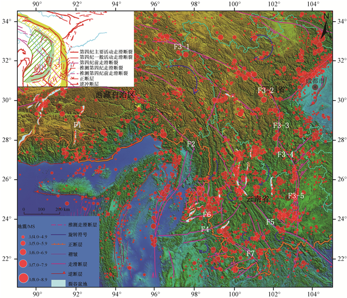
图 2 青藏高原东南缘活动构造体系图及震中分布图(左上角为“川滇弧形旋钮活动构造体系”①)
Ⅰ川滇外弧带:Ⅰ-1—玉树-鲜水河-安宁河-则木河-小江-Dien-Bien-Phu边界变形带;Ⅰ-2—雅江-楚雄-景洪断块区;Ⅱ滇西内弧带(中甸—保山弧形扭旋活动构造体系):Ⅱ-1—理塘-大理-瑞丽边界变形带;Ⅱ-2—泸水-保山断块区;F1—错那-沃卡裂谷;F2—东喜马拉雅构造结;F3-1—玉树-甘孜断裂;F3-2—鲜水河断裂;F3-3—安宁河断裂;F3-4—则木河断裂;F3-5—小江断裂;F4—南汀河断裂;F5—红河断裂;F6—畹町断裂;F7—澜沧断裂-景洪断裂
Figure 2. Active tectonic system about the southeastern margin of the Tibetan Plateau and epicenter distribution

图 3 典型震例地震围空区及围空地震震中分布
Figure 3. Seismic gap of the typical earthquakes and epicenter distribution

图 4 发震震级与地震围空区特征值之间关系
a—震级M与围空区平均震级m线性关系;b—震级M与围空区形成时长T线性关系(察隅8.6级地震围空时间T不参与计算,其震中位置位于板块俯冲边界,地震孕震时间短,与过渡带地震孕震时间模型不一致);
c—震级M与围空区轴长L线性关系(汶川地震与当雄地震震级均为8.0级、轴长分别为201 km和202 km,所以在图上有重叠);d—震级M与围空区面积S线性关系Figure 4. Relationships of earthquake magnitude with the characteristic values of seismic gap

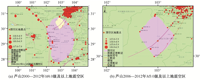
图 5 雅安地区2000—2012年地震围空区
Figure 5. Seismic gaps with different magnitudes in Yaan area from the year 2000 to 2012

图 6 不同时段、不同震级地震围空区预测图
Figure 6. Prediction maps of seismic gap of different time and earthquake magnitudes
表 1 青藏高原东南缘历史地震围空区特征值统计
Table 1. The characteristics of history seismic gap around the southeastern margin of the Tibetan Plateau
编号 发震时间 发震断裂 震中
位置纬度 经度 空区
名称M 地震围空区特征参数 m T/a L/km S/km2 m 1 1950-08-15 喜马拉松山前主边界逆冲断裂带 察隅 28.24 96.42 察隅 8.6 6 28 426 27367 6.70 2 1951-11-18 崩错断裂带 当雄 31.06 91.24 当雄 8.0 5 31 202 8598 5.78 3 1955-04-14 鲜水河断裂带东南段 康定西南 30.00 101.48 康定 7.5 5 20 167 4019 5.83 4 1970-01-05 峨山—曲江断裂带 通海 24.20 102.68 通海 7.7 6 49 273 7313 6.20 5 1973-02-06 鲜水河断裂带西段 炉霍附近 31.30 100.70 炉霍 7.6 5 21 240 6082 5.69 6 1976-05-29 龙陵—龙新共轭走滑断裂带 龙陵东部 24.50 99.00 龙陵 7.3 5 19 230 8202 5.49 7 1988-11-06 澜沧—景洪断裂带北西段 澜沧北部 22.92 99.79 澜沧 7.4 5 18 222 6809 5.82 8 1995-07-11 勐连断裂带 勐连西部 21.96 99.16 勐连 7.3 3 11 31 215 4.72 9 1996-02-03 哈巴—玉龙雪山东麓断裂 丽江 27.32 100.33 丽江 7.1 3 20 87 637 3.88 10 2008-05-12 龙门山断裂带中段 汶川 31.01 103.42 汶川 8.0 6 54 201 4299 6.63 11 2010-04-14 玉树—甘孜断裂带玉树段 玉树隆宝湖北 33.22 96.59 玉树 7.1 4 25 125 2994 4.10 注:M为发震震级;m为围空地震震级起点;T为围空时间;L为围空区轴长;S为围空区面积;为围空地震平均震级  下载: 导出CSV
表 2 青藏高原东南缘现今主要地震围空区特征与参数
Table 2. Characteristics and Parameters of present seismic gap around the southeastern margin of Tibetan Plateau
编
号围空区主要
活动构造或断裂时间段 持续时间 震
级地震围空区特征 地震围空区发震震级 N m T/a L/km S/km 2 M(m) M(T) M(L) M(S) m Ⅰ 错那—沃卡裂谷 1950—2012 1951—2010 6 15 6.51 60 310 18697 7.99 8.15 7.97 8.18 7.82±0.19 1970—2012 1987—2009 5 11 5.53 23 297 11714 7.60 7.53 7.92 7.83 1970—2012 1970—2010 6 12 6.28 41 289 14503 7.90 7.84 7.89 7.97 1990—2012 1992—2010 5 10 5.62 19 285 10770 7.64 7.47 7.88 7.79 2005—2012 2005—2012 5 15 5.63 8 287 17318 7.64 7.28 7.89 8.12 Ⅱ 东喜马拉雅构造结 1950—2012 1950—1989 6 14 6.63 56 225 9793 8.04 8.09 7.68 7.74 7.86±0.28 1970—2012 1075—2003 5 20 5.38 29 262 10501 7.54 7.63 7.80 7.77 1970—2012 1996—2008 6 12 6.41 13 298 9197 7.95 7.37 7.92 7.71 1970—2012 1970—2011 6 17 6.28 42 474 22830 7.90 7.85 8.52 8.39 1990—2012 1992—2009 5 22 5.47 18 273 13980 7.58 7.45 7.84 7.95 2005—2012 2005—2012 5 14 5.38 8 391 33521 7.54 7.28 8.24 8.93 Ⅲ 安宁河—则木河断裂带 1950—2012 1952—2008 6 12 6.47 57 145 6076 7.98 8.10 7.40 7.55 7.66±0.16 1970—2012 1970—2012 5 23 5.43 43 166 6387 7.56 7.87 7.48 7.57 1970—2012 1970—2010 5 26 5.46 40 209 4438 7.57 7.82 7.62 7.47 1970—2012 1974—2008 6 10 6.38 35 245 8026 7.94 7.73 7.74 7.65 1990—2012 1991—2012 5 16 5.59 22 168 6007 7.62 7.52 7.48 7.55 2005—2012 2005—2012 5 17 5.64 8 275 11863 7.64 7.28 7.85 7.84 Ⅳ 南汀河断裂东段—红河断裂沅江段 1950—2012 1951—2009 6 18 6.55 59 213 7676 8.01 8.14 7.64 7.63 7.66±0.18 1970—2012 1970—2006 5 21 5.63 37 176 3865 7.64 7.77 7.51 7.44 1970—2012 1970—2009 6 17 6.54 40 188 6453 8.00 7.82 7.55 7.57 1990—2012 1993—2007 5 11 5.43 15 172 3640 7.56 7.40 7.50 7.43 Ⅴ 畹町断裂—南汀河断裂带 1950—2012 1971—2012 6 15 6.51 42 182 7827 7.99 7.85 7.53 7.64 7.69±0.14 1970—2012 1971—2012 5 19 5.72 42 167 9373 7.68 7.85 7.48 7.72 1970—2012 1971—2012 6 12 6.43 41 167 7356 7.96 7.84 7.48 7.62 1990—2012 1990—2012 5 16 5.79 23 188 6356 7.70 7.53 7.55 7.57 Ⅳ &
Ⅴ畹町断裂—南汀河断裂带 2005—2012 2005—2012 5 20 5.62 8 349 17895 7.64 7.28 8.10 8.14 7.79±0.33 Ⅵ 澜沧—景洪断裂东南段 1950—2012 1950—2007 6 9 6.42 58 101 1671 7.96 8.12 7.26 7.33 7.6±0.23 1970—2012 1972—2007 5 12 5.44 36 90 1299 7.56 7.75 7.22 7.31 1970—2012 1973—2003 6 15 6.55 41 221 5879 8.01 7.84 7.66 7.54 1990—2012 1995—2007 5 9 5.76 13 197 1747 7.69 7.37 7.58 7.34 注:N为围空地震数量;M为围空地震震级;T为围空时间;L为围空区轴长;S为围空区面积;m为围空地震平均震级;M(m)以m相关的线性关系推算发震震级,误差±0.2;M(T)以T相关的线性关系推算发震震级,误差±0.14;M(L)以L相关的线性关系推算发震震级,误差±0.24;M(S)以S相关的线性关系推算发震震级,误差为±0.2;m为围空区不同时间段汇总的平均震级
下载: 导出CSV
-
[1] 国家地震局震害防御司.中国历史强震目录(公元前23世纪—公元1911年)[M].北京:地震出版社, 1995.The Department of Seismic Hazard Prevention of SSB. Catalog of the history strong earthquakes in China (23 century BC to 1911 AD)[M]. BeiJing: Seismological Press, 1995. [2] 唐荣昌, 韩渭宾.四川活动断裂与地震[M].北京:地震出版社, 1993: 67, 117.TANG Rong-chang, HAN Wei-bin. Active faults and earthquakes in Sichuan Province[M]. Beijing: Seismological Press, 1993: 67, 117. [3] 吴中海, 赵根模, 龙长兴, 等.青藏高原东南缘现今大震活动特征及其趋势:活动构造体系角度的初步分析结果[J].地质学报, 2014, 88(8): 1401~1416. http://www.cnki.com.cn/Article/CJFDTOTAL-DZXE201408004.htmWU Zhong-hai, ZHAO Gen-mo, LONG Chang-xing, et al. The seismic hazard assessment around south-east area of Qinghai-Xizang Plateau: A preliminary results from active tectonics system analysis[J]. Acta Geologica Sinica, 2014, 88(8):1401~1416. http://www.cnki.com.cn/Article/CJFDTOTAL-DZXE201408004.htm [4] 吴中海, 赵希涛, 范桃园, 等.泛亚铁路滇西大理至瑞丽沿线主要活动断裂与地震地质特征[J].地质通报, 2012, 31(2/3): 191~217. http://www.cnki.com.cn/Article/CJFDTOTAL-ZQYD2012Z1001.htmWU Zhong-hai, ZHAO Xi-tao, FAN Tao-yuan, et al.Active faults and seismologic characteristics along the Dali-Ruili railway in western Yunnan Province[J]. Geological Bulletin of China, 2012, 31(2/3): 191~217. http://www.cnki.com.cn/Article/CJFDTOTAL-ZQYD2012Z1001.htm [5] 张肇诚.震例总结研究探讨[M].北京:地震出版社, 2013.ZHANG Zhao-cheng. The studies and investigation of seismic cases summary[M]. Beijing: Seismological Press, 2013. [6] M7专项工作组.中国大陆大地震中长期危险性研究[M].北京:地震出版社, 2013.Working Group of M7. Study on the mid-to long-term potential of large earthquakes on the Chinese Continent[M]. Beijing: Seismological Press, 2013. [7] 郭安林, 张国伟, 姚安平.地质数据库建立中的系统分析[J].西北大学学报:自然科学版, 2004, 34(2): 203~206. http://www.cnki.com.cn/Article/CJFDTOTAL-XBDZ200402020.htmGUO An-lin, ZHANG Guo-wei, YAO An-ping. System analysis in building geological database[J]. Journal of Northwest University: Natual Science Editon, 2004, 34(2): 203~206. http://www.cnki.com.cn/Article/CJFDTOTAL-XBDZ200402020.htm [8] 郭伟娜, 毛先成, 陈振.综合地质数据库结构设计与管理系统开发[J].金属矿山, 2009, (6): 136~139. http://www.cnki.com.cn/Article/CJFDTOTAL-JSKS200906046.htmGUO Wei-na MAO Xian-cheng, CHEN Zhen. Development of the design and management system of generalized geological database structure[J]. Metal Mine, 2009, (6): 136~139. http://www.cnki.com.cn/Article/CJFDTOTAL-JSKS200906046.htm [9] 张望, 洪金益.矿产资源空间数据库的分析与设计[J].西部探矿工程, 2009, (6): 127~131. http://www.cnki.com.cn/Article/CJFDTOTAL-XBTK200906045.htmZHANG Wang, HONG Jin-yi. Analysis and design of mineral resource spatial database[J]. West-China Exploration Engineering, 2009, (6): 127~131. http://www.cnki.com.cn/Article/CJFDTOTAL-XBTK200906045.htm [10] 曾卫华.石油地质空间数据库的建立与应用[J].油气地球物理, 2010, 8(1): 23~26. http://www.cnki.com.cn/Article/CJFDTOTAL-YQDL201001006.htmZENG Wei-hua. The establishment and application of the geologic spatial database[J]. Petroleum Geophysics, 2010, 8(1): 23~26. http://www.cnki.com.cn/Article/CJFDTOTAL-YQDL201001006.htm [11] 李永兵, 陈旭瑞, 胡俊峰, 等.基于GIS的地质数据库系统:研究现状和发展趋势[J].地球物理学进展, 2002, 17(3): 532~539. http://www.cnki.com.cn/Article/CJFDTOTAL-DQWJ200203024.htmLI Yong-bing, CHEN Xu-rui, HU Jun-feng, et al. The geologic database system with GIS: Research status in quo and development trend[J]. Progress in Geophysics, 2002, 17(3): 532~539. http://www.cnki.com.cn/Article/CJFDTOTAL-DQWJ200203024.htm [12] 屈春燕.最新1/400万中国活动构造空间数据库的建立[J].地震地质, 2008, 30(1): 298~304. http://www.cnki.com.cn/Article/CJFDTOTAL-DZDZ200801022.htmQU Chun-yan. Building to the active tectonic database of China[J]. Seismology and Geology, 2008, 30(1): 298~304. http://www.cnki.com.cn/Article/CJFDTOTAL-DZDZ200801022.htm [13] 李斌, 朱筱敏, 孟昊, 等.开放性地质空间数据库的设计与应用[J].地理信息空间, 2012, 10(1): 29~34. http://www.cnki.com.cn/Article/CJFDTOTAL-DXKJ201201011.htmLI Bin, ZHU Xiao-min, MENG Hao, et al. Design and application of opening geological spatial database[J]. Geospacial Information, 2012, 10(1): 29~34. http://www.cnki.com.cn/Article/CJFDTOTAL-DXKJ201201011.htm [14] Chang Kang-tsung.地理信息系统导论[M].陈建飞, 译.北京:清华大学出版社, 2009.Chang Kang-tsung. Introduction to Geographic Information Systems[M].CHEN Jian-fei, translated. Beijing: Tsinghua University Press, 2009. [15] 吴信才.空间数据库[M].北京:科教出版社, 2006.WU Xin-cai. Spatial database[M]. Beijing: Science and Education Press, 2006. [16] 杨海军, 邵全琴.GIS空间分析技术在地理数据处理中的应用研究[J].地球信息科学, 2007, 9(5): 70~75. http://www.cnki.com.cn/Article/CJFDTOTAL-DQXX200705015.htmYANG Hai-jun, SHAO Quan-qin. Consideration on GIS spatial analysis in geospatial data processing[J]. Geo-Information Science, 2007, 9(5): 70~75. http://www.cnki.com.cn/Article/CJFDTOTAL-DQXX200705015.htm [17] 黄杏元, 马劲松.地理信息系统概论[M].北京:高等教育出版社, 1990.HUANG Xing-yuan, MA Jin-song. Foundation of Geographic Information Systems[M]. Beijing: Higher Education Press, 1990. [18] 王学军.空间分析技术与地理信息系统的结合[J].地理研究, 1997, 16 (3): 70~74. http://www.cnki.com.cn/Article/CJFDTOTAL-COLO201703142.htmWANG Xue-jun. The combination of spatial analysis technique and GIS[J]. Geographical Research, 1997, 16(3): 70~74. http://www.cnki.com.cn/Article/CJFDTOTAL-COLO201703142.htm [19] 龚健雅.空间数据库管理系统的概念与发展趋势[J].测绘科学, 2001, 26(3): 4~9. http://www.cnki.com.cn/Article/CJFDTOTAL-FGGL201703028.htmGONG Jian-ya. Concepts and development of spatial database management[J]. Science of Surveying and Mapping, 2001, 26(3): 4~9. http://www.cnki.com.cn/Article/CJFDTOTAL-FGGL201703028.htm [20] 程昌秀.空间数据库管理系统概论[M].北京:科学出版社, 2012.CHENG Chang-xiu. Foundation of spatial database management system[M]. Beijing: Science Press, 2012. [21] 胡忠宇.面向对象的全关系型GIS空间数据库的研究[J].测绘科学, 2009, 34(增刊): 118~120. http://www.cnki.com.cn/Article/CJFDTOTAL-CHKD2009S2045.htmHU Zhong-yu. Mensuration method of fixed attitude delay of survey vessel[J]. Science of Surveying and Mapping, 2009, 34(Supp.): 118~120. http://www.cnki.com.cn/Article/CJFDTOTAL-CHKD2009S2045.htm [22] ESRI.ArcGIS Engine开发指南[M].ESRI中国(北京)有限公司, 2011.ESRI. The development guide to ArcGIS Engine[M]. Beijing: ESRI China (Beijing) Co., LTD, 2011. [23] Zeiler M. Modeling our world: The ESRI guide to geodatabase design[M]. California: ESRI Press, 1999: 115~125. [24] Cunningham G, Silvertand G. Managing a Versioned Geodatabase[M]. New York: ESRI Press, 2005. [25] 邓起东.断层性状、盆地类型及其形成机制[J].地震科学研究, 1984, (3): 56~64.DENG Qi-dong. Fault traits, basin types and their formation mechanism[J]. Earthquake Science Research, 1984, (3): 56~64. [26] 张秋文, 张培震.地理信息系统在地震危险性分析中的应用[J].地壳形变与地震, 1999, 19(1): 82~86. http://www.cnki.com.cn/Article/CJFDTOTAL-DKXB901.012.htmZHANG Qiu-wen, ZHANG Pei-zhen. Application of Geographic Information System (GIS) to seismic risk analysis[J]. Crustal Deformation and Earthquake, 1999, 19(1): 82~86. http://www.cnki.com.cn/Article/CJFDTOTAL-DKXB901.012.htm [27] 易桂喜, 闻学泽, 范军, 等.由地震活动参数分析安宁河—则木河断裂带的现今活动习性及地震危险性[J].地震学报, 2004, 26(3): 294~303. http://www.cnki.com.cn/Article/CJFDTOTAL-DZXB200403007.htmYI Gui-xi, WEN Xue-ze, FAN Jun, et al. Assessing current faulting behaviors and seismic risk of the Anninghe-Zemuhe fault zone from seismicity parameters[J]. Acta Seismologica Sinca, 2004, 26(3): 294~303. http://www.cnki.com.cn/Article/CJFDTOTAL-DZXB200403007.htm [28] 张国民.我国地震监测预报研究的主要科学进展[J].地震, 2002, 22(1): 2~8. http://www.cnki.com.cn/Article/CJFDTOTAL-DIZN200201000.htmZHANG Guo-min.The main science advances of earthquake monitoring and prediction in China[J]. Earthquake, 2002, 22(1): 2~8. http://www.cnki.com.cn/Article/CJFDTOTAL-DIZN200201000.htm [29] 张国民, 陈章立.我国地震前兆和预报的探索[J].中国地震, 1987, 3(增刊): 2~11. http://www.cnki.com.cn/Article/CJFDTOTAL-ZGZD1987S1000.htmZHANG Guo-min, CHEN Zhang-li. Research on the earthquake precursors and prediction of in China[J]. Earthquake Research in China, 1987, 3(Supp.): 2~11. http://www.cnki.com.cn/Article/CJFDTOTAL-ZGZD1987S1000.htm [30] Mogi K. Two kinds of seismic gaps[J]. Pure and Applied Geophysics, 1979, 117(6): 1172~1186. doi: 10.1007/BF00876213 [31] Fedotov S A. Regularities of the distribution of strong earthquakes in Kamchatka, the Kurile Islands, and north-east Japan[J]. Tr Inst Fiz Zemli Akad Nauk SSSR, 1965, 36: 66~93. [32] Sykes L R. Aftershock zones of great earthquakes, seismicity gaps, and earthquake prediction for Alaska and the Aleutians[J]. Journal of Geophysical Research, 1971, 76(32): 8021~8041. doi: 10.1029/JB076i032p08021 [33] Scholz C H. The mechanics of earthquakes and faulting[M]. Cambridge: Cambridge University Press, 1990. [34] Slemmons D B, Depolo C M. Evaluation of active faulting and associated hazards[C]//Wallace R E. Active tectonics. Washington D C: National Academy Press, 1986: 45~62. [35] 张肇诚, 郑大林, 罗咏生.《中国震例》前兆资料的初步研究[J].地震, 1990, 10(5): 9~24. http://www.cnki.com.cn/Article/CJFDTOTAL-DIZN199005001.htmZHANG Zhao-cheng, ZHENG Da-lin, LUO Yong-sheng. Preliminary research on the precursory data from Earthquake Cases in China[J]. Earthquake, 1990, 10(5): 9~24. http://www.cnki.com.cn/Article/CJFDTOTAL-DIZN199005001.htm [36] 胡聿贤.工程地震学[M].北京:地震出版社, 1995.HU Yu-xian. Engineering seismology[M]. Beijing: Seismological Press, 1995. [37] 董治平, 杨立明, 姚军.青藏高原北部地区地震空区初步研究[J].地震研究, 2005, 28(1): 6~11. http://www.cnki.com.cn/Article/CJFDTOTAL-DZYJ200501001.htmDONG Zhi-ping, YANG Li-ming, YAO Jun. Preliminary study on the seismic gap in the northern area of the Qinghai-Tibet Plateau[J]. Journal of Seismological Research, 2005, 28(1): 6~11. http://www.cnki.com.cn/Article/CJFDTOTAL-DZYJ200501001.htm [38] 援藏考察队.当雄地震、察隅地震考察概况[J].四川地震, 1986, 3(1): 39~41. http://www.cnki.com.cn/Article/CJFDTOTAL-SCHZ198601009.htmTibet Expedition Team. An overview of the investigation on Dangxiong and Chayu earthquakes[J]. Sichuan Earthquake, 1986, 3(1): 39~41. http://www.cnki.com.cn/Article/CJFDTOTAL-SCHZ198601009.htm [39] 吴中海, 张永双, 胡道功, 等.西藏错那—沃卡裂谷带中段邛多江地堑晚新生代正断层作用[J].地质力学学报, 2007, 13(4): 297~307. http://journal.geomech.ac.cn/ch/reader/view_abstract.aspx?file_no=20070439&flag=1WU Zhong-hai, ZHANG Yong-shuang, HU Dao-gong, et al. Late Cenozoic narmal faulting of the qungdogyang graben in the central segment of the Cona-Qiga rift, southeastern Tibet[J]. Journal of Geomechanics, 2007, 13(4): 297~307. http://journal.geomech.ac.cn/ch/reader/view_abstract.aspx?file_no=20070439&flag=1 [40] 吴中海, 张永双, 胡道功, 等.藏南错那—沃卡裂谷的第四纪正断层作用及其特征[J].地震地质, 2008, 30(1): 144~160. http://www.cnki.com.cn/Article/CJFDTOTAL-DZDZ200801010.htmWU Zhong-hai, ZHANG Yong-shuang, HU Dao-gong, et al. The quaternary normal faulting of the Cona-Qiga rift[J]. Seismology and Geology, 2008, 30(1): 144~160. http://www.cnki.com.cn/Article/CJFDTOTAL-DZDZ200801010.htm [41] 宋治平, 张国民, 刘杰, 等.全球地震目录[M].北京:地震出版社, 2011.SONG Zhi-ping. ZHANG Guo-min, LIU Jie, et al. Global earthquake catalog[M]. Beijing: Seismological Press, 2011. [42] 时振梁, 赵荣国, 王淑贞, 等.世界地震目录[M].北京:地图出版社, 1986.SHI Zhen-liang, ZHAO Rong-guo, WANG Shu-zhen, et al. The world's earthquake catalog[M]. Beijing: Map Press, 1986. [43] 张培震, 徐锡伟, 闻学泽, 等.2008年汶川8.0级地震发震断裂的滑动速率、复发周期和构造成因[J].地球物理学报, 2008, 5l(4): 1066~1073. http://www.cnki.com.cn/Article/CJFDTOTAL-DQWX200804017.htmZHANG Pei-zhen, XU Xi-wei, WEN Xue-ze, et al. Slip rates and recurrence intervals of the Longmenshan active fault zone, and tectonic implications for the mechanism of the May 12 Wenchuan earthquake, 2008, Sichuan, China[J]. Chinese Journal of Geophysics, 2008, 51(4): 1066~1073. http://www.cnki.com.cn/Article/CJFDTOTAL-DQWX200804017.htm [44] 徐锡伟, 闻学泽, 叶建青, 等.汶川8.0地震地表破裂带及其发震构造[J].地震地质, 2008, 30(3): 597~629. http://cpfd.cnki.com.cn/Article/CPFDTOTAL-ZGYJ200904001009.htmXU Xi-wei, WEN Xue-ze, YE Jian-qing, et al. The MS 8.0 Wenchuan earthquake surface ruptures and its seismogenic structure[J]. Seismology and Geology, 2008, 30(3): 597~629. http://cpfd.cnki.com.cn/Article/CPFDTOTAL-ZGYJ200904001009.htm [45] 闻学泽, 张培震, 杜方, 等.2008年汶川8.0级地震发生的历史与现今地震活动背景[J].地球物理学报, 2009, 52(2): 444~454. http://www.cnki.com.cn/Article/CJFDTOTAL-DQWX200902017.htmWEN Xue-Ze, ZHANG Pei Zhen, DU Fang, et al. The background of historical and modern seismic activities of the occurrence of the 2008 MS 8.0 Wenchuan, Sichuan, earthquake[J]. Chinese Journal of Geophysics, 2008, 30(3): 597~629. http://www.cnki.com.cn/Article/CJFDTOTAL-DQWX200902017.htm [46] 闻学泽.川西安宁河断裂上的地震空区[J].中国科学D辑:地球科学, 2008, 38(7): 797~807. http://www.cnki.com.cn/Article/CJFDTOTAL-JDXK200807002.htmWEN Xue-ze. The seismic gap on the Anninghe fault around the western Sichuan[J]. Science in China Series D: Earth Science, 2008, 38(7): 797~807. http://www.cnki.com.cn/Article/CJFDTOTAL-JDXK200807002.htm [47] 王琪, 赖锡安, 游新兆, 等.红河断裂的GPS监测与现代构造应力场[J].地壳形变与地震, 1998, 18(2): 49~56. http://www.cnki.com.cn/Article/CJFDTOTAL-DKXB802.006.htmWANG Qi, LAI Xi-an, YOU Xin-zhao, et al. GPS measurement and present tectonic stress field in the Honghe fault, southwest China[J]. Crustal, Deformation and Earthquake, 1998, 18(2): 49~56. http://www.cnki.com.cn/Article/CJFDTOTAL-DKXB802.006.htm [48] 吴中海, 叶培盛, 吴珍汉.2008年10月6日西藏当雄MS 6.6级强震的地震烈度控震构造和发震机理[J].地质通报, 2008, 28(6): 713~725.WU Zhong-hai, YE Pei-sheng, WU Zhen-han. The seismic intensity, seismogenic tectonics and mechanism of the MS 6.6 Damxung earthquake happened on October 6, 2008 in southern Tibet, China[J]. Geological Bulletin of China, 2008, 28(6): 713~725. -

 下载:
下载:


计量
- 文章访问数: 437
- HTML全文浏览量: 187
- PDF下载量: 26
- 被引次数: 0
