

ANALYSIS OF GEOMORPHOLOGIC CHARACTERISTICS OF THE YAMZHO YUMCO REGION BASED ON ASTER-GDEM
-
摘要: 基于ASTER-GDEM数据, 运用GIS空间分析统计技术, 通过对数字地形高程、地表起伏度、地表坡度等地貌参数的统计和条带剖面及面积-高程积分等数字地貌分析, 结合前人的区域地质资料及野外实地调查和验证, 对藏南羊卓雍错地区的构造地貌特征进行了初步分析, 旨在为研究区的盆地地貌格局演化分析提供依据。研究结果表明, 研究区构造地貌总体为一近东西向盆地, 最高海拔7515 m, 最低海拔2581 m, 属于高海拔-极高海拔区域; 流域内以平原和丘陵地貌为主, 平均起伏度为314 m, 平均坡度19°, 地势起伏较小, 发育有三级层状地貌; 盆地边缘受断裂的控制, 构造现象发育, 线性影像特征明显。其东、西部分别受桑日-错那断陷带和亚东-露谷断陷带所围限, 具有多期构造活动特征。盆地南北两侧受绒布-哲古断裂和邛多江断裂控制较弱。受构造活动和地表水流综合作用的影响, 盆地内部地貌已进入老龄化阶段。
-
关键词:
- ASTER-GDEM /
- 羊卓雍错 /
- 构造地貌 /
- 流域面积-高程积分
Abstract: The DEM data, gradually advancing, is applied widespreadly in the analysis of geomorphic. In order to provide important evidences for the tectonic pattern and evolution process of geomorphy in the study area, with detailed field survey and verification as well as searching and compare with former regional geologic data, the characteristics of tectonic geomorphy have been studied, based on data of ASTER-GDEM, the utilization of GIS spatial analysis statistic technology, statistics of geomorphic parameters including the terrain elevation(including the average elevation, the maximum elevation and the minimum elevation), the terrain fluctuation and the surface gradient, graphic and mathematic analysis of the strip profile and the area-elevation integral. The result shows that the study area, characterized by the EW directional basin geomorphy, with highest altitude of 7515 m and lowest altitude of 2581 m, belongs to the area of high-extremely high altitude, while areas within the watershed mainly exhibits geomorphy of plain and hill. With the average fluctuation of 314 m, average gradient of 19°, the terrain fluctuates little and shows layered geomorphy of three grades. The edge of the basin is controlled by faults, where tectonic phenomena develop with obvious characteristics of linear imagines. The east and west part are controlled by the Sangri-Cuona fault belt and the Yadong-Lugu fault belt respectively, in which multi-period tectonic activities are revealed by the elevation profile. Additionally, the south and north part of the watershed basin is controlled by the Rongbu-Zhegu fault and the Qiuduojiang fault, and the faulting in north is more intensive than that in south. Influenced by the combined action of tectonic activities and surface water flow, the geomorphy has entered the aging stage of evolution.-
Key words:
- ASTER-GDEM /
- Yamzho Yumco /
- geomorphologic /
- curve of hypsometric integral
-

图 3 羊卓雍错地区4种高程图
a-平均高程图;b-最大高程图;c-最小高程图;d-地势起伏度图
Figure 3. Four types of DEM maps of the YamzhoYumco region

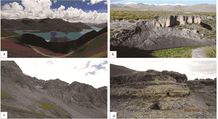
图 4 羊卓雍错地区地貌特征与湖相沉积
a-盆内丘陵地貌;b-盆内平原地貌及河流侵蚀V型谷;c-盆地边缘陡峭山体;d-高位湖相沉积(海拔4844m)
Figure 4. Geomorphologic characteristics of the YamzhoYumco region and it's lake sediments

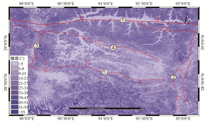
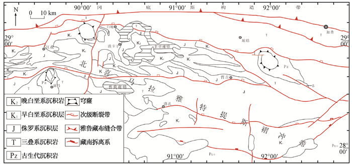
图 6 羊卓雍错地区坡度分级示意图
①-雅鲁藏布江构造带;②-桑日-错那断陷带;③-亚东-露谷断陷带;④-邛多江断裂;⑤-绒布-哲古断裂
Figure 6. Slope classification schematic diagram of the YamzhoYumco region

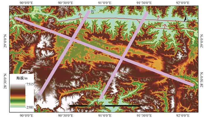
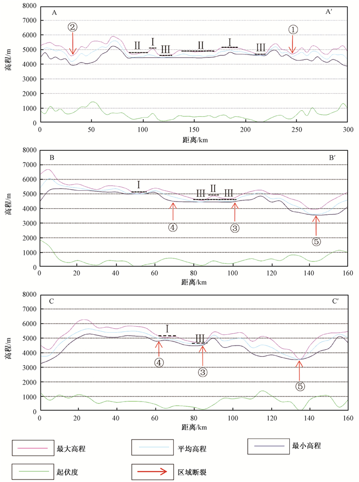
图 7 羊卓雍错地区A、B、C条带剖面图
① 康马-羊八井-那曲断陷带;② 桑日-错那断陷带;③ 札达-拉孜-邛多江断裂;④ 绒布-古堆断裂;⑤ 雅鲁藏布构造带
Figure 7. Swath profile graph of the YamzhoYumco region

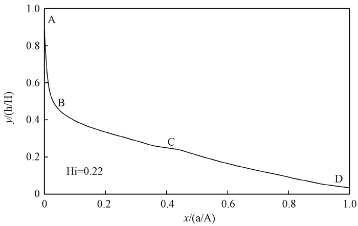
图 9 羊卓雍错流域面积—高程积分曲线图
Figure 9. Curve of hypsometric integral in the YamzhoYumco watershed
表 1 羊卓雍错地区高程统计
Table 1. Height statistics of the YamzhoYumco region
高程/m 百分比/% 累计百分比/% < 3500(中海拔) 0.23 0.23 3500~5000(高海拔) 3500~4000 8.25 8.48 4000~4500 19.42 27.90 4500~5000 37.19 65.09 > 5000(极高海拔) 34.91 100.00  下载: 导出CSV
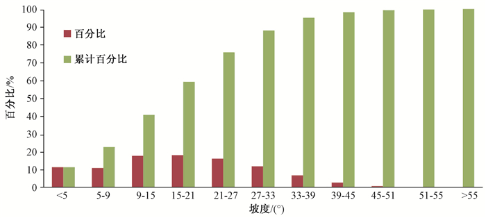
表 2 羊卓雍错地区地势起伏度统计
Table 2. Amplitude statistics of the YamzhoYumco region
起伏度划分/m 平原 丘陵 小起伏山地 中起伏山地 大起伏山地 0~30 30~200 200~500 500~1000 1000~2500 百分比/% 2.45 22.83 62.44 12.10 0.18 累计百分比/% 2.45 25.28 87.72 99.82 100.00
下载: 导出CSV
-
[1] SUMMERFIELD M A.Global geomorphology[M]. Harlow: Longman Scientfic & Technical, 1991: 1~367. [2] 张瑞军, 杨武年, 刘汉湖, 等.数字高程模型(DEM)的构建及其应用[J].工程勘察, 2005, (5): 61~64. http://cdmd.cnki.com.cn/Article/CDMD-10497-2005078395.htmZHANG Rui-Jun, YANG Wu-Nian, LIU Han-Hu, et al. The building and its application of DEM[J]. Geotechnical Investigation & Surveying, 2005, (5): 61~64. http://cdmd.cnki.com.cn/Article/CDMD-10497-2005078395.htm [3] 张会平, 杨农, 刘少峰, 等.数字高程模型(DEM)在构造地貌研究中的应用新进展[J].地质通报, 2006, 25(6): 660~669. http://www.cnki.com.cn/Article/CJFDTOTAL-ZQYD200606002.htmZHANG Hui-Ping, YANG Nong, LIU Shao-Feng, et al. Recent progress in the DEM-based tectonogeomorphic stuay[J]. Geological Bulletin of China, 2006, 25(6): 660~669. http://www.cnki.com.cn/Article/CJFDTOTAL-ZQYD200606002.htm [4] Field E J. How flat is Tibet?[J]. Geology, 1994, 22: 163~167. doi: 10.1130/0091-7613(1994)022<0163:HFIT>2.3.CO;2 [5] Duncan C, Masek J, Fielding E. How steep are the Himalaya: Characteristics and implications of along-strike Topographic Variations[J]. Geology January, 2003, 31(1): 75~78. doi: 10.1130/0091-7613(2003)031<0075:HSATHC>2.0.CO;2 [6] 洪顺英, 申旭辉, 荆凤, 等.基于SRTM-DEM的阿尔泰山构造地貌特征分析[J].国土资源遥感, 2007, 18(3): 62~66. doi: 10.6046/gtzyyg.2007.03.14HONG Shun-Ying, SHEN Xu-Hui, JING Feng, et al. An analysis of geomorphology characteristics of the Altai Mountain based on DEM[J]. Remote Sensing for Land And Resources, 2007, (3): 62~66. doi: 10.6046/gtzyyg.2007.03.14 [7] 张会平, 杨农, 张岳桥, 等.岷江水系流域地貌特征及其构造指示意义[J].第四纪研究, 2006, 26(1): 126~135. http://www.cnki.com.cn/Article/CJFDTOTAL-DSJJ200601015.htmZHANG Hui-ping, YANG Nong, ZHANG Yue-qiao, et al. Geomorphology of the Minjiang Drainage System (Sichuan, China) and its structural implications[J]. Quaternary Sciences, 2006, 26 (1) : 126~135. http://www.cnki.com.cn/Article/CJFDTOTAL-DSJJ200601015.htm [8] 郑绵平, 袁鹤然, 赵希涛, 等.青藏高原第四纪泛湖期与古气候[J].地质学报, 2006, 80(2): 169~180. http://www.cnki.com.cn/Article/CJFDTOTAL-DZXE200602000.htmZHENG Mian-Ping, YUAN He-Ran, ZHAO Xi-tao, et al. The Quaternary Pan-lake (Overflow) Period and Paleoclimate on the Qinghai-Tibet Plateau[J]. Acta Geologica Sinica, 2006, 80(2): 169~180. http://www.cnki.com.cn/Article/CJFDTOTAL-DZXE200602000.htm [9] 西藏自治区地质矿产局.西藏自治区区域地质志[M].北京:地质出版社, 1991.Bureau of Geology and Mineral Resources of Tibet Autonomous Region. Regional geology of Tibet Autonomous Region[M]. Beijing: Geological Publishing House, 1993. [10] 鲁如魁, 钟华明, 童劲松, 等.西藏洛扎地区拆离断层构造变形特征[J].大地构造与成矿学, 2005, 29(2): 189~197. http://www.cnki.com.cn/Article/CJFDTOTAL-DGYK200502004.htmLU Ru-kui, ZHONG Hua-ming, TONG Jin-song, et al. Tectonic deformation features of the detachment fault in Luozha area, Tibet[J]. Geotectonica Et Metallogenia, 2005, 29(2): 189~197. http://www.cnki.com.cn/Article/CJFDTOTAL-DGYK200502004.htm [11] 戚学祥, 李天福, 孟祥金, 等.藏南特提斯喜马拉雅前陆断褶带新生代构造演化与锑金多金属成矿作用[J].岩石学报, 2008, 24(7): 1638~1648. http://www.cnki.com.cn/Article/CJFDTOTAL-YSXB200807021.htmQI Xue-xiang, LI Tian-fu, MENG Xiang-jin, et al. Cenozoic tectonic evolution of the Tethyan Himalaya foreland fault-fold belt insouthern Tibet, and its constraint on antimony-gold polymetallic minerogenesis[J]. Acta Petrologica Sinica, 24(7): 1638~1648. http://www.cnki.com.cn/Article/CJFDTOTAL-YSXB200807021.htm [12] Taud H, Parrot J F, Alvarez R. DEM generation by contour line dilation[J]. Computers & Geosciences, 1999, 25: 775~783. http://www.sciencedirect.com/science/article/pii/S0098300499000199 [13] Bielecki A E, Mueller K J. Origin of terraced hillslopes on active folds in the southern San Joaquin Valley, California[J]. Geomorphology, 2002, 42: 131~152. doi: 10.1016/S0169-555X(01)00082-4 [14] Montgomery D R. Valley incision and the uplift of mountain peaks[J]. Geophys, 1994, 99(B7): 13913~13921. doi: 10.1029/94JB00122 [15] 张学儒, 官冬杰, 牟凤云, 等.基于ASTER-GDEM数据的青藏高原东部山区地形起伏度分析[J].地理与地理信息科学, 2012, 28(3): 11~14. http://www.cnki.com.cn/Article/CJFDTOTAL-DLGT201203005.htmZHANG Xue-ru, GUAN Dong-jie, MU Feng-yun, et al. Analysis on the relief amplitude based on ASTER GDEM data in mountain area of eastern Tibetan Plateau[J]. Geography and Geo-Information Science, 2012, 28(3): 11~14. http://www.cnki.com.cn/Article/CJFDTOTAL-DLGT201203005.htm [16] 程三友, 刘少峰, 张会平, 等.大别山构造地貌的DEM初步分析[J].地质力学学报, 2005, 11(4): 333~340. http://journal.geomech.ac.cn/ch/reader/view_abstract.aspx?flag=1&file_no=20050447&journal_id=dzlxxbCHENG San-you, LIU Shao-feng, ZHANG Hui-Ping, et al. DEM analysis of the tectonogeomorphology of the Dabieshan orogenic belt[J]. Journal of Geomechanics, 2005, 11 (4): 333~340. http://journal.geomech.ac.cn/ch/reader/view_abstract.aspx?flag=1&file_no=20050447&journal_id=dzlxxb [17] 韩同林.西藏活动构造[M].北京:地质出版社, 1987: 13~22.HAN Tong-ling. The active tectonic in Tibet[M]. Beijing: Geological Publishing House, 1987: 13~22. [18] 贺日政, 高锐.西藏高原南北向裂谷研究意义[J].地球物理学进展, 2003, 18(1): 35~43. http://www.cnki.com.cn/Article/CJFDTOTAL-DQWJ200301006.htmHE Ri-zheng, GAO Rui. Some significances of studying north-southern rift in Tibet Plateau[J]. Progress in Geophysics, 2003, 18(1): 35~43. http://www.cnki.com.cn/Article/CJFDTOTAL-DQWJ200301006.htm [19] 吴中海, 张永双, 胡道功, 等.藏南错那—沃卡裂谷的第四纪正断层作用及其特征[J].地震地质, 2008, 30(1): 144~160. http://www.cnki.com.cn/Article/CJFDTOTAL-DZDZ200801010.htmWU Zhong-hai, ZHANG Yong-shuang, HU Dao-gong, et al. The Quaternary normal faulting of the Cona-Oiga rift[J]. Seismology and Geology, 2008, 30(1): 144~160. http://www.cnki.com.cn/Article/CJFDTOTAL-DZDZ200801010.htm [20] 陈正位, 谢平, 申旭辉, 等.构造和气候共同控制下的藏南热隆盆地中更新世以来的演化[J].地震, 2007, 27(3): 131~138. http://www.cnki.com.cn/Article/CJFDTOTAL-DIZN200703019.htmCHEN Zheng-wei, XIE Ping, SHEN Xu-hui, et al. Evolution of Relong Basin in southern Tibet controlled by both tectonics and climate since mid-Pleistocene[J]. Earthquake, 2007, 27(3): 131~138. http://www.cnki.com.cn/Article/CJFDTOTAL-DIZN200703019.htm [21] 黄荣才.藏南隆子―措美一带构造特征浅析[J].四川地质学报, 2012, 32(增刊): 28~32. http://www.cnki.com.cn/Article/CJFDTOTAL-SCDB2012S1009.htmHUANG Rong-cai. Analysis of the tectonic characteristics in longzi-cuomei[J]. Journal of Sichuan Geology, 2012, 32(Supp.): 28~32. http://www.cnki.com.cn/Article/CJFDTOTAL-SCDB2012S1009.htm [22] 孙东, 王道永.雅鲁藏布江缝合带中段构造特征及成因模式新见解[J].地质学报, 2011, 85(1): 56~65. http://www.cnki.com.cn/Article/CJFDTOTAL-DZXE201101003.htmSUN Dong, WANG Dao-yong. Structure features of the Middle Yarlung Zangbo Suture Zone and a new knowledge of its genetic model[J]. Acta Geologica Sinica, 2011, 85(1): 56~65. http://www.cnki.com.cn/Article/CJFDTOTAL-DZXE201101003.htm [23] 张会平, 刘少峰.利用DEM进行地形高程剖面分析的新方法[J].地学前缘, 2004, 11(3): 226. http://www.cnki.com.cn/Article/CJFDTOTAL-DXQY200403028.htmZHANG Hui-ping, LIU Shao-feng. A new method of using DEM terrain elevation profile analysis[J]. Earth Science Frontiers, 2004, 11(3): 226. http://www.cnki.com.cn/Article/CJFDTOTAL-DXQY200403028.htm [24] 邹斌文, 马维峰, 龙昱, 等.基于ArcGIS的条带剖面提取方法在地貌分析中的应用[J].地理与地理信息科学, 2011, 27(3): 42~44. http://www.cnki.com.cn/Article/CJFDTOTAL-DLGT201103011.htmZOU Bin-wen, MA Wei-feng, LONG Yu, et al. Extraction method of swath profile based on ArcGIS and its application in landform analysis[J]. Geography and Geo-Information Science, 2011, 27(3): 42~44. http://www.cnki.com.cn/Article/CJFDTOTAL-DLGT201103011.htm [25] 阚瑷珂, 朱利东, 龚建辉, 等.基于ArcView的带状剖面工具开发及在地貌分析中的应用[J].成都理工大学学报:自然科学版, 2006, 33(1): 64~69. http://www.cnki.com.cn/Article/CJFDTOTAL-CDLG200601011.htmKAN Ai-ke, ZHU Li-dong, GONG Jian-hui, et al. Development of the swath profile tool based on ArcView GIS and its application in morphometric analysis[J]. Journal of Chengdu University of Technology: Science & Technology Edition, 2006, 33(1): 65~69. http://www.cnki.com.cn/Article/CJFDTOTAL-CDLG200601011.htm [26] Fielding E J. Tibet uplift and erosion[J]. Tectonophysics, 1996, 260(1/3): 55~84. [27] 孟宪刚, 邵兆刚, 韩建恩.青藏高原古近纪—新近纪重点古湖泊环境演变序列[M].北京:地质出版社, 2011: 13~15.MENG Xian-gang, SHAO Zhao-gang, HAN Jian-en. On the paleogene-neogene environmental evolution of the key paleolakes, Tibet[M]. Beijing: Geological Publishing House, 2011: 13~15. [28] Silva Pablo G, Goy J L, Zazo C, et al. Fault-generated mountain fronts in southeast Spain: Geomorphologic assessment of tectonic and seismic activity[J]. Geomorphology, 2003, 50(1/3): 203~225. http://www.academia.edu/4299788/Fault-generated_mountain_fronts_in_southeast_Spain_geomorphologic_assessment_of_tectonic_and_seismic_activity [29] Ramírez-Herrera M T. Geomorphic assessment of active tectonics in the Acambay Graben, Mexican volcanic belt[J]. Earth Surface Processes and Landforms, 1998, 23(4): 317~332. doi: 10.1002/(ISSN)1096-9837 [30] 李利波, 徐刚, 胡健民, 等.基于DEM的活动构造研究[J].中国地质, 2012, 39(3): 595~604. http://cdmd.cnki.com.cn/Article/CDMD-85402-1012266156.htmLI Li-bo, XU Gang, HU Jian-min, et al. An analysis of relative active tectonics based on DEM[J]. Geology in China, 2012, 39(3): 595~604. http://cdmd.cnki.com.cn/Article/CDMD-85402-1012266156.htm [31] Harlin J M. Watershed morpheme try and time to hydrograph peak[J]. Journal of Hydrology, 1984, 67: 141~154. doi: 10.1016/0022-1694(84)90238-5 -

 下载:
下载:


计量
- 文章访问数: 428
- HTML全文浏览量: 243
- PDF下载量: 20
- 被引次数: 0
