

Analysis on the development law of active geological hazards in the Loess Plateau based on InSAR identification
-
摘要: 地震、降雨、人类工程活动诱发的活动性地质灾害在黄土高原频现,但由于其地域广阔、构造活跃、地貌类型多样、各地黄土特性差异较大,一直以来缺乏活动性地质灾害发育分布的系统认识。InSAR技术具有大范围观测地表变形的能力,文章利用2019年1月1日至2020年3月31日期间40期Sentinal-1 SAR数据,计算了整个黄土高原62.46×10⁴ km2的地表变形,辅助地貌和光学影像特征,解译了4类活动性地质灾害,共解译出活动性地质灾害3286处,其中滑坡1135处、采矿塌陷1691处、沉降368处、堆填变形体92处,同时对其活动发育规律进行了分析。黄土高原活动性地质灾害主要分布在八大区域,包括四大滑坡发育区、三大采矿塌陷分布区和一个沉降灾害分布区。活动性滑坡在空间分布上具有显著的区域性和丛集性,主要分布在中西部,滑坡体的发育密度与地形地貌有一定联系;采矿塌陷和地面沉降分布在中东部,密集且成群发育。地质灾害发育具有明显的时空发生规律,区域尺度上,地质灾害的发育密集程度受地形地貌和矿产资源的控制;灾害规模上,InSAR识别的灾害规模都为中型以上,与传统统计手段有一定差别。InSAR的识别结果客观反映了黄土高原地质灾害的分布规律。同时,InSAR技术能够有效监测到地下采煤诱发的地表破坏的分布、范围和强度以及露天采煤矿坑深度和范围的扩展,进而推断煤业生产活动强度。Abstract: Active geological disasters induced by earthquakes, rainfalls and human engineering activities occur frequently in the Loess Plateau. However, there is a lack of systematic understanding of the development and distribution of active geological disasters in the Loess Plateau due to the wide area, active structure, diverse landforms and great difference in loess characteristics. InSAR technology can observe surface deformation in a wide range. Based on 40 sentinal-1 SAR data from January 1, 2019 to March 31, 2020, a total of 3286 active geological disasters in the Loess Plateau of 624, 600 km2 were interpreted by InSAR, including 1135 landslides, 1691 mining collapses, 368 subsidences and 92 landfills. Combined with geomorphological and optical image characteristics, four types of active geological hazards were interpreted, which reveals that they are mainly distributed in eight regions, including four landslide areas, three mining collapse areas and one subsidence area. The spatial distribution of active landslides is obviously regional and clustered, concentrating in the middle and west of China; while that of mining collapse and land subsidence densely developed in groups in the middle and west of China. There is a relationship between landslide development density and topography. The development of these geological disasters has an obvious spatio-temporal regularity. Regionally, the development intensity of geological disasters is controlled by topography and mineral resources; and in terms of scale, disasters identified by InSAR are all above medium size, which is different from traditional statistical methods. InSAR identification results objectively reflect the distribution of geological disasters in the Loess Plateau, and deepened our understanding on that as well. InSAR technique, meanwhile, can effectively detect the surface damage induced by underground coal mining, including its distribution, scope, strength, and monitor the depth and scope of opencast coal mine, and then infer the intensity of coal production activities.
-
Key words:
- active geological hazards /
- Loess Plateau /
- InSAR /
- landslide /
- coal mining collapse
-

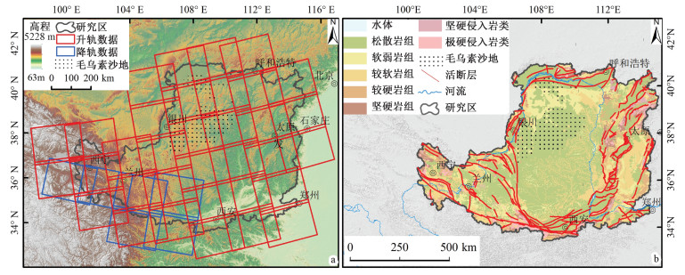
图 1 研究区InSAR观测范围及工程地质岩组分布
a-研究区位置和背景数据图;b-研究区工程地质岩组和活动断裂分布
Figure 1. InSAR observation range and enigneering geological formation-complexes distribution in the study area
(a) Location and background data; (b) Distribution of engineering geological formation-complexes and active faults

图 2 黄土高原地质灾害InSAR变形图与光学影像图
a-滑坡InSAR变形图;b-滑坡光学影像图;c-采矿塌陷InSAR变形图;d-采矿塌陷光学影像图;e-沉降InSAR变形图;f-沉降光学影像图;g-堆填变形体InSAR变形图;h-堆填变形体光学影像图
Figure 2. InSAR-observed deformation and optical images of geological hazards in the Loess Plateau
(a) InSAR-observed deformation image of landslides; (b) Optical image of landslides; (c) InSAR-observed deformation of mining collapses; (d) Optical image of mining collapses; (e) InSAR-observed deformation of subsidences; (f) Optical image of subsidences; (g) InSAR-observed deformation of landfills; (h) Optical image of landfills

图 3 黄土高原活动性地质灾害分布
Ⅰ区-青海东缘黄河中上游滑坡发育区;Ⅱ区-宁夏东南缘固原-西吉滑坡发育区;Ⅲ区-甘肃庄浪-天水-张家川滑坡发育区;Ⅳ区-陕北吴起-志丹-延安-安塞黄土滑坡发育区;Ⅴ区-宁夏采矿塌陷灾害区;Ⅵ区-陕北-内蒙古鄂尔多斯采矿塌陷灾害区;Ⅶ区-山西采矿塌陷灾害区;Ⅷ区-关中-汾渭-洛阳平原地区沉降发育区
Figure 3. Distribution of active geological hazards in the Loess Plateau
Area Ⅰ-Landslide development area in the upper and middle reaches of the Yellow River, eastern margin of Qinghai; Area Ⅱ-Guyuan-Xiji landslide development area in the southeastern margin of Ningxia; Area Ⅲ-Zhuanglang-Tianshui-Zhangjiachuan landslide development area in Gansu; Area Ⅳ-Wuqi-Zhidan-Yan'an-Ansai loess landslide development area in northern Shaanxi; Area Ⅴ-Mining collapse area in Ningxia; Area Ⅵ-Mining collapse area in Ordos, Inner Mongolia and Northern Shaanxi; Area Ⅶ-Mining collapse area in Shanxi; Area Ⅷ-Subsidence development area in the plain area of Guanzhong-Fenwei-Luoyang

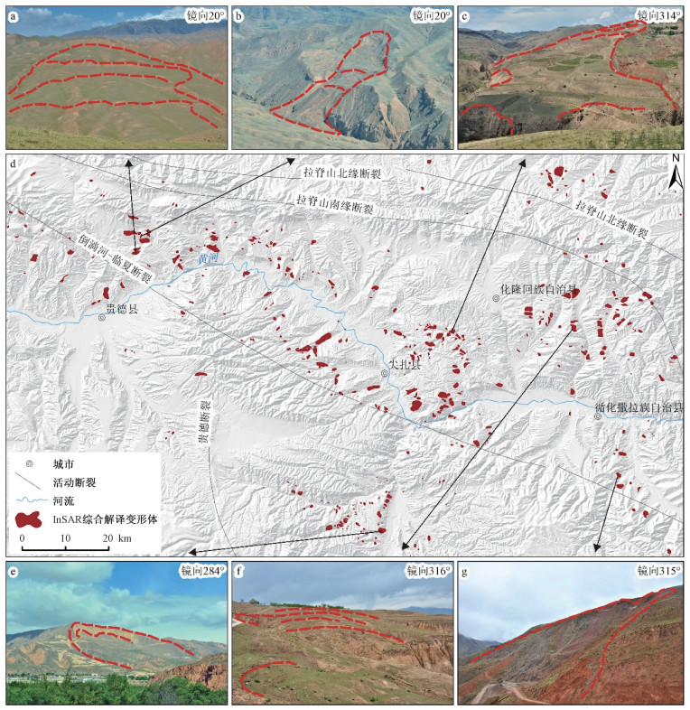
图 4 青海东缘黄河流域侵蚀滑坡段及现场典型照片
a-高原草甸蠕滑变形滑坡;b-侵蚀多级滑坡1;c-侵蚀多级滑坡2;d-滑坡分布图;e-圈椅状滑坡地貌;f-拉裂缝;g-片麻岩斜坡
Figure 4. Map and field photos showing the eroded landslides in the Yellow River Basin, eastern margin of Qinghai
(a) Creep deformation landslide of plateau meadow; (b) Eroded multi-stage landslide 1; (c) Eroded multi-stage landslide 2; (d) Distribution of landslides; (e) Armchair-like landslide landform; (f) Tensile fracture; (g) Gneiss slope

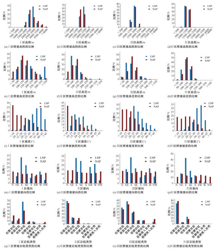
图 5 黄土高原活动性滑坡地貌因子统计
Ⅰ区-青海东缘黄河中上游滑坡发育区;Ⅱ区-宁夏东南缘固原-西吉滑坡发育区;Ⅲ区-甘肃庄浪-天水-张家川滑坡发育区;Ⅳ区-陕北吴起-志丹-延安-安塞黄土滑坡发育区
Figure 5. Statistics of geomorphologic factors of active landslides in the Loess Plateau
AreaⅠ-Landslide development area in the upper and middle reaches of the Yellow River, eastern margin of Qinghai; Area Ⅱ-Guyuan-Xiji landslide development area in the southeastern margin of Ningxia; Area Ⅲ-Zhuanglang-Tianshui-Zhangjiachuan landslide development area in Gansu; Area Ⅳ-Wuqi-Zhidan-Yan'an-Ansai loess landslide development area in northern Shaanxi
表 1 黄土高原研究区各岩土体类型地质灾害发育情况
Table 1. Development of geological hazards in different types of rocks and soil in the study area
岩土体类型 滑坡/处 采矿塌陷/处 沉降/处 堆填开挖变形/处 合计 松散岩组 290 539 306 61 1196 软弱岩组 186 478 29 7 700 较软岩组 535 623 31 17 1206 较硬岩组 44 37 0 4 85 坚硬岩组 56 3 1 0 60 坚硬侵入岩类 3 8 1 0 12 极硬侵入岩类 21 3 0 3 27 合计 1135 1691 368 92 3286  下载: 导出CSV
表 2 黄土高原最易发活动性滑坡地貌区段统计
Table 2. Statistics of the geomorphic sections most prone to active landslides in the study area
区域 Ⅰ区 Ⅱ区 Ⅲ区 Ⅳ区 高程/m 2500~3000 2000~2500 1500~2000 1000~1500 高差/m 100~150 50~100 50~100 100~150 坡度/(°) 40~45 15~20 20~25 35~40 坡向 东 东 东 东 岩组类型 较软岩组 松散岩组 软弱岩组 松散岩组
下载: 导出CSV
-
CAO J L, WANG R F, ZHANG J P, et al., 2004. Environmental geological problems in mining areas in Shanxi Province and present state of their study[J]. Geological Bulletin of China, 23(11): 1119-1126. (in Chinese with English abstract) CHENG T, SHAN X J, DONG W T, et al., 2008. A study of landslide distribution in loess area with InSAR[J]. Hydrogeology and Engineering Geology, 35(1): 98-101. (in Chinese with English abstract) GUO S C, HOU H P, ZHANG S L, et al., 2017. Surface deformation monitoring of the mining area in Loess Plateau based on D-InSAR[J]. Science of Surveying and Mapping, 42(6): 207-212. (in Chinese with English abstract) HAN S F, ZHAO B Q, YIN Z M, et al., 2020. The identification of potential geological hazards on the Loess Plateau based on PS InSAR technology[J]. Journal of Lanzhou University: Natural Sciences, 56(1): 1-7. (in Chinese with English abstract) HE Y, 2016. Identification and Monitoring of the loess landslide by using of high resolution remote sensing and InSAR[D] Xi'an: Chang'an University. (in Chinese with English abstract) HU S, 2019. Spatial pattern of landslide in Loess Plateau and its influence on geomorphologic evolution[D]. Xi'an: Northwest University. (in Chinese with English abstract) HUANG T K, JEN C S, JIANG C F, et al., 1977. An outline of the tectonic characteristics of China[J]. Acta Geological Sinica (2): 117-135. (in Chinese with English abstract) LEI X Y, 2001. Geological disasters and human activities on the Loess Plateau of China[M]. Beijing: Geological Press. (in Chinese) LI M, DU J W, GAO W Y, 2009. Study on the relationship between geological disasters and precipitation in the Loess Plateau in north Shaanxi Province[J]. Arid Zone Research, 26(4): 599-606. (in Chinese with English abstract) LI Y, MENG H, DONG Y, et al., 2004. Main Types and characterisitics of geo-hazard in China: Based on the results of geo-hazard survey in 290 counties[J]. The Chinese Journal of Geological Hazard and Control, 15(2): 29-34. (in Chinese with English abstract) LIU X H, YAO X, ZHOU Z K, et al., 2018. Study of the technique for landslide rapid recognition by InSAR[J]. Journal of Geomechanics, 24(2): 229-237. (in Chinese with English abstract) MIN L R, 1984. The Tectonic movement of quaternary in Loess Plateau of China[J]. Bulletin of the Chinese Academy of Geological Sciences (9): 225-236. (in Chinese with English abstract) PENG D L, XU Q, LIU F Z, et al., 2018. Distribution and failure modes of the Landslides in Heitai Terrace, China[J]. Engineering Geology, 236: 97-110. doi: 10.1016/j.enggeo.2017.09.016 PENG J B, LIN H Z, WANG Q Y, et al., 2014. The critical issues and creative concepts in mitigation research of loess geological hazards[J]. Journal of Engineering Geology, 22(4): 684-691. (in Chinese with English abstract) PENG J B, WANG S K, WANG Q Y, et al., 2019. Distribution and genetic types of loess landslides in China[J]. Journal of Asian Earth Sciences, 170: 329-350. doi: 10.1016/j.jseaes.2018.11.015 PENG J B, WANG Q Y, ZHUANG J Q, et al., 2020. Dynamic formation mechanism of landslide disaster on the Loess Plateau[J]. Journal of Geomechanics, 26(5): 714-730. (in Chinese with English abstract) SUN P P, ZHANG M S, CHENG X J, et al., 2019. On the regularity of geological hazards on the Loess Plateau in China[J]. Mountain Research, 37(5): 737-746. (in Chinese with English abstract) WANG N Q, 2004. Study on the growing laws and controlling measures for loess landslide[D]. Chengdu: Chengdu University of Technology. (in Chinese with English abstract) WANG S K, 2020. Study on the mechanisms for geohazards of macro loess discontinuities[D]. Xi'an: Chang'an University. (in Chinese with English abstract) WANG Z X, 2017. Boundary data of Loess Plateau region[J]. Journal of Global Change Data & Discovery, 1(1): 113, 236. (in Chinese with English abstract) XU C, WU X Y, XU X W, 2018. Earthquake-triggered landslides in the loess plateau and its adjacent areas[J]. Journal of Engineering Geology, 26(S1): 260-273. (in Chinese with English abstract) XU L, DAI F C, TU X B, et al., 2014. Landslides in a Loess Platform, North-West China[J]. Landslides, 11(6): 993-1005. doi: 10.1007/s10346-013-0445-x XU L P, 2008. Influence and reciprocal effects of vegetation rehabilitation on regional climate in Loess Plateau[D] Yangling: Northwest A & F University. (in Chinese with English abstract) XU Z J, LIN Z G, ZHANG M S, 2007. Loess in China and loess landslides[J]. Chinese Journal of Rock Mechanics and Engineering, 26(7): 1297-1312. (in Chinese with English abstract) YAO X, DENG J H, LIU X H, et al., 2020. Primary recognition of active landslides and development rule analysis for pan Three-river-parallel Territory of Tibet Plateau[J]. Advanced Engineering Sciences, 52(5): 16-37. (in Chinese with English abstract) YUAN L X, 2006. Forming mechanism of the Loess Landslides in Xiji of Ningxia with Low-Angle, High speed and far-distance[J]. Journal of Disaster Prevention and Mitigation Engineering, 26(2): 219-223. (in Chinese) ZHAO C Y, LIU X J, ZHANG Q, et al., 2019. Research on loess landslide identification, monitoring and failure mode with InSAR technique in Heifangtai, Gansu[J]. Geomatics and Information Science of Wuhan University, 44(7): 996-1007. (in Chinese with English abstract) ZHAO D L, LANCUO Z M, HOU G L, et al., 2021. Assessment of geological disaster susceptibility in the Hehuang Valley of Qinghai Province[J]. Journal of Geomechanics, 27(1): 83-95. (in Chinese with English abstract) ZHOU J X, ZHU C Y, ZHENG J M, et al., 2002. Landslide disaster in the loess Area of China[J]. Journal of Forestry Research, 13(2): 157-161. doi: 10.1007/BF02857244 ZHU Z Y, 1992. Neotectonics and Neotectonic movement of the Loess Plateau and its adjacent regions[J]. Quaternary Sciences, 12(3): 252-264. (in Chinese with English abstract) 曹金亮, 王润福, 张建萍, 等, 2004. 山西省矿山环境地质问题及其研究现状[J]. 地质通报, 23(11): 1119-1126. doi: 10.3969/j.issn.1671-2552.2004.11.012 程滔, 单新建, 董文彤, 等, 2008. 利用InSAR技术研究黄土地区滑坡分布[J]. 水文地质工程地质, 35(1): 98-101. doi: 10.3969/j.issn.1000-3665.2008.01.022 郭山川, 侯湖平, 张绍良, 等, 2017. D-InSAR的黄土高原矿区地表形变监测[J]. 测绘科学, 42(6): 207-212. https://www.cnki.com.cn/Article/CJFDTOTAL-CHKD201706036.htm 韩守富, 赵宝强, 殷宗敏, 等, 2020. 基于PS InSAR技术的黄土高原地质灾害隐患识别[J]. 兰州大学学报: 自然科学版, 56(1): 1-7. https://www.cnki.com.cn/Article/CJFDTOTAL-LDZK202001001.htm 何杨, 2016. 高分遥感与InSAR技术在黄土滑坡识别和监测中的应用研究[D]. 西安: 长安大学. 胡胜, 2019. 黄土高原滑坡空间格局及其对地貌演化的影响[D]. 西安: 西北大学. 黄汲清, 任纪舜, 姜春发, 等, 1977. 中国大地构造基本轮廓[J]. 地质学报(2): 117-135. https://www.cnki.com.cn/Article/CJFDTOTAL-DZXE197702002.htm 雷祥义, 2001. 黄土高原地质灾害与人类活动[M]. 北京: 地质出版社. 李明, 杜继稳, 高维英, 2009. 陕北黄土高原区地质灾害与降水关系[J]. 干旱区研究, 26(4): 599-606. https://www.cnki.com.cn/Article/CJFDTOTAL-GHQJ200904025.htm 李媛, 孟晖, 董颖, 等, 2004. 中国地质灾害类型及其特征: 基于全国县市地质灾害调查成果分析[J]. 中国地质灾害与防治学报, 15(2): 29-34. doi: 10.3969/j.issn.1003-8035.2004.02.005 刘星洪, 姚鑫, 周振凯, 等, 2018. 滑坡灾害InSAR应急排查技术方法研究[J]. 地质力学学报, 24(2): 229-237. doi: 10.12090/j.issn.1006-6616.2020.26.05.059 闵隆瑞, 1984. 中国黄土高原第四纪构造运动[J]. 中国地质科学院院报(9): 225-236. https://www.cnki.com.cn/Article/CJFDTOTAL-DQXB198402019.htm 彭建兵, 林鸿州, 王启耀, 等, 2014. 黄土地质灾害研究中的关键问题与创新思路[J]. 工程地质学报, 22(4): 684-691. https://www.cnki.com.cn/Article/CJFDTOTAL-GCDZ201404018.htm 彭建兵, 王启耀, 庄建琦, 等, 2020. 黄土高原滑坡灾害形成动力学机制[J]. 地质力学学报, 26(5): 714-730. doi: 10.12090/j.issn.1006-6616.2020.26.05.059 孙萍萍, 张茂省, 程秀娟, 等, 2019. 黄土高原地质灾害发生规律[J]. 山地学报, 37(5): 737-746. https://www.cnki.com.cn/Article/CJFDTOTAL-SDYA201905011.htm 王念秦, 2004. 黄土滑坡发育规律及其防治措施研究[D]. 成都: 成都理工大学. 王少凯, 2020. 黄土宏观界面及其控灾机制研究[D]. 西安: 长安大学. 王正兴, 2017. 黄土高原地区[J]. 全球变化数据学报(中英文), 1(1): 113, 236. https://www.cnki.com.cn/Article/CJFDTOTAL-QQSJ201701018.htm 许冲, 吴熙彦, 徐锡伟, 2018. 黄土高原及邻区的地震滑坡[J]. 工程地质学报, 26(S1): 260-273. https://cpfd.cnki.com.cn/Article/CPFDTOTAL-GCDZ201810001038.htm 徐丽萍, 2008. 黄土高原地区植被恢复对气候的影响及其互动效应[D]. 杨凌: 西北农林科技大学. 徐张建, 林在贯, 张茂省, 2007. 中国黄土与黄土滑坡[J]. 岩石力学与工程学报, 26(7): 1297-1312. doi: 10.3321/j.issn:1000-6915.2007.07.001 姚鑫, 邓建辉, 刘星洪, 等, 2020. 青藏高原泛三江并流区活动性滑坡InSAR初步识别与发育规律分析[J]. 工程科学与技术, 52(5): 16-37. https://www.cnki.com.cn/Article/CJFDTOTAL-SCLH202005003.htm 袁丽侠, 2006. 宁夏西吉县低角高速远程黄土滑坡及其形成机理分析[J]. 防灾减灾工程学报, 26(2): 219-223. https://www.cnki.com.cn/Article/CJFDTOTAL-DZXK200602017.htm 赵超英, 刘晓杰, 张勤, 等, 2019. 甘肃黑方台黄土滑坡InSAR识别、监测与失稳模式研究[J]. 武汉大学学报(信息科学版), 44(7): 996-1007. https://www.cnki.com.cn/Article/CJFDTOTAL-WHCH201907005.htm 赵东亮, 兰措卓玛, 侯光良, 等, 2021. 青海省河湟谷地地质灾害易发性评价[J]. 地质力学学报, 27(1): 83-95. doi: 10.12090/j.issn.1006-6616.2021.27.01.009 朱照宇, 1992. 黄土高原及邻区新构造与新构造运动[J]. 第四纪研究, 12(3): 252-264. doi: 10.3321/j.issn:1001-7410.1992.03.007 -

 下载:
下载:


计量
- 文章访问数: 1885
- HTML全文浏览量: 669
- PDF下载量: 165
- 被引次数: 0
