

Application of integrated model based on EEMD-CNN-LSTM for landslide-displacement prediction
-
摘要: 滑坡位移预测是滑坡稳定性评价的重要环节。尽管基于深度学习范式的时间序列方法预测滑坡位移取得了一定的成果,但由于滑坡位移数据的非平稳性、周期性和趋势性变化特征,导致当前时间序列模型的滑坡位移的多变量预测容易过拟合。为解决这一问题,针对滑坡位移数据的波动性和由周期项与趋势项位移叠加组成的特性,提出一种基于孤立森林(Isolation Forest,IF)异常检测、集成经验模态分解(Ensemble Empirical Mode Decomposition,EEMD)、卷积神经网络(Convolutional Neural Networks,CNN)和长短期记忆神经网络(Long Short-Term Memory,LSTM) 相结合的滑坡位移预测模型。选择三峡库区以降雨为影响因子的阶跃型白家包滑坡为研究对象,引入IF算法对滑坡原始位移数据进行异常检测,使用EEMD方法提取滑坡趋势项和周期项位移,通过CNN捕捉局部周期项和趋势模式,并基于LSTM模型预测总体位移。结果表明,EEMD-CNN-LSTM在预测降雨情况时滑坡总体位移的均方根误差(RMSE)、平均绝对误差(MAE)、评价绝对百分比误差(MAPE)和决定系数(R2)4种指标分别为0.4190、0.3139、0.2379和0.9997,前3种精度评价指标较现有模型分别提升32.3%、25.1%、7.3%。相较于传统的LSTM模型、随机森林方法和EEMD-LSTM方法,EEMD-CNN-LSTM模型在有、无降雨这一外部影响因素下具有显著优势,能够较大地降低过拟合,提高预测的准确性。Abstract:
Objective Landslide-displacement prediction is critical when evaluating landslide stability. Despite the achievements of time-series methods based on deep-learning paradigms in predicting landslide displacement, the nonstationary, periodic, and trending characteristics of landslide displacement data cause multivariate predictions of current time-series models to easily overfit. Existing studies primarily focus on improving single models, whereas systematic studies pertaining to multimodel integration methods are scarce. This study aims to develop an integrated model that addresses these challenges and improves prediction accuracy. Methods Considering the volatility of landslide-displacement data and the combined characteristics of their periodic and trending displacement components, a landslide-displacement prediction model combining isolation forest (IF) anomaly detection, ensemble empirical mode decomposition (EEMD), convolutional neural networks (CNNs), and long short-term memory (LSTM) neural networks is proposed. The stepped Baijiabao landslide in the Three Gorges Reservoir area, which is affected by rainfall, is investigated in this study. First, the IF algorithm is introduced to detect anomalies in the original landslide-displacement data. This enables outliers, which can distort the prediction results, to be identified and excluded. Subsequently, EEMD is adopted to decompose the displacement data into intrinsic mode functions (IMFs), which represent the underlying periodic and trend components. This decomposition allows one to analyze the inherent characteristics of the data more comprehensively. Next, a CNN is employed to capture local periodic and trend patterns within the IMFs. CNNs are particularly effective in recognizing spatial patterns and features, thus rendering them suitable for identifying complex patterns in the displacement data. Finally, the overall displacement is predicted using the LSTM model, which is suitable for accommodating sequential data and capturing long-term dependencies. These techniques are integrated to leverage their respective strengths, thereby improving the prediction accuracy. Result The results indicate that the root-mean-square error(RMSE), mean absolute error(MAE), absolute percentage error in evaluation (MAPE), and determination coefficient(R2)indices of the EEMD-CNN-LSTM model for predicting the overall landslide displacement under rainfall conditions are 0.4190, 0.3139, 0.2379, and 0.9997, respectively, which signify improvements in the accuracy of the first three evaluation indices by 32.3%, 25.1%, and 7.3%, respectively, compared with those of existing models. This significant improvement demonstrates the model’s robustness in accommodating the complexities of landslide-displacement data under varying conditions. For predictions without rainfall, the RMSE, MAE, MAPE, and R2 indices are 0.4302, 0.2908, 0.2431, and 0.9996, respectively, which signify improvements in the accuracy of the first three indices by 31.2%, 31.7%, and 8.7%, respectively, compared with those of existing models. These results highlight the model’s high generalizability across different scenarios, as it can maintain high prediction accuracies regardless of external influencing factors such as rainfall. Compared with conventional LSTM, random forest, and EEMD-LSTM models, the EEMD-CNN-LSTM model offers significant advantages under the influence of rainfall and without rainfall, thus significantly reducing overfitting and improving the prediction accuracy. The hybrid approach effectively captures the intricate patterns in the data, which cannot be achieved by single models. Conclusion In summary, the multimodel integration method based on IF anomaly detection, EEMD decomposition, local-feature capturing by the CNN, and overall prediction by LSTM significantly improves the accuracy of landslide-displacement prediction, particularly under the influence of rainfall. The integrated model not only addresses the overfitting issues typically encountered in time-series prediction models but also enhances the model’s robustness and reliability. The combination of IF for anomaly detection ensures that outliers do not skew the prediction results, whereas EEMD facilitates the decomposition of data into meaningful components. The CNN’s ability to capture local patterns, coupled with the LSTM’s strength in modeling long-term dependencies, enables the establishment of a comprehensive framework that can effectively accommodate the complexities of landslide displacement data.[ Significance ]This study provides an effective multimodel integration method for landslide-displacement prediction, which addresses the overfitting issues in existing models as well as offers substantial scientific significance and practical value. The proposed model’s ability to accurately predict landslide displacement under varying conditions is extremely beneficial to the stability evaluation of landslide-prone areas, thereby contributing to disaster prevention and mitigation efforts. The innovation is based on the systematic integration of anomaly detection, data decomposition, and advanced neural-network techniques, which results in a robust framework that outperforms conventional methods. The findings of this study are applicable to real-world scenarios, thereby enhancing the accuracy and reliability of landslide monitoring systems and supporting informed decision-making in hazard management and infrastructure development. -
0. 引言
湖滩岩是在特定气候、水化学条件下、于特定地貌部位沉积并成岩的,是反映古湖面变化的重要沉积记录,因此,可以根据它的岩性、岩相及其时代,揭示湖泊的湖面变化过程及相关的气候环境意义。
赛里木湖位于新疆维吾尔自治区博尔塔拉蒙古自治州博乐市境内,又称三台海子,经纬度为80°59′—81°22′ E,44°30′—44°43′ N,湖泊形状大体上呈棱形,长轴东西向,长约30 km,短轴南北向,长约27 km[1~2],为新构造期间北天山西段在近南北向挤压缩短变形过程中所形成的一个断陷湖。该湖的湖面海拔2071.9 m,面积453 km2,最深处约86 m,储水量约21×109 m3,是新疆面积最大的高山冷水湖。
2011年期间,笔者在赛里木湖盆地开展1:50000第四纪地质填图和湖泊演化研究过程中,沿该湖泊的湖岸阶地或湖积台地发现了与古湖面波动直接相关的湖滨相沉积物记录——湖滩岩。之前有研究者对其他地区湖泊的类似沉积物进行过沉积相、矿物岩石学特征和同位素测年等方面的研究,并将这种发育于湖泊周缘,在特定环境和特定地貌部位形成的,能够直接反映古湖面波动的特殊湖相沉积岩定名为湖滩岩[3~7]。已有研究认为,湖滩岩多分布于湖积阶地与古湖岸堤的顶部,是湖岸堤形成过程中因湖水的蒸发作用造成碳酸盐类矿物结晶、并胶结湖滨相砂砾石所形成,因此,都以钙质胶结砂砾岩面貌出现。简而言之,湖滩岩是一种形成在湖岸潮间带上的由碳酸盐胶结湖相砂、砾石沉积物的富碳酸盐类胶结岩。
1. 赛里木湖滩岩的发现及其分布特征
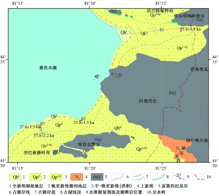
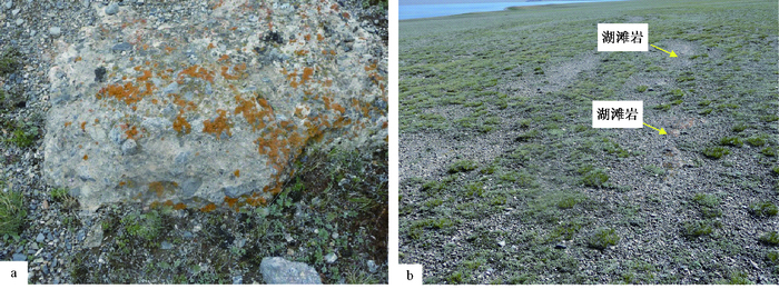
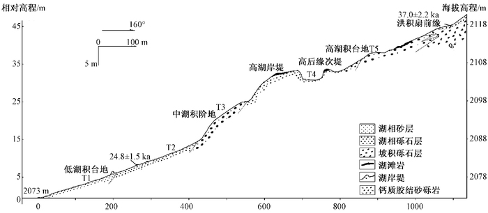
赛里木湖盆地的第四纪地质填图结果表明,赛里木湖沿岸分布有多级主要由湖相砂、砾石沉积物所组成的湖岸阶地和由湖滨相砾石堆积所构成的古湖岸堤以及相关的湖蚀崖(见图 1)等湖岸地貌,尤其是古湖岸堤、湖蚀崖沿湖周缘间断分布,地貌特征非常显著。湖滩岩主要沿该湖泊周缘的古湖岸堤呈不连续分布,最常见于赛里木湖东南部的古湖岸线呈半封闭状的古湖湾内侧(见图 1)。基本的分布特点是:① 都出现在古湖岸呈半封闭的区域上;② 都发育在现代湖水退缩后的滨湖地带——湖积台地和古湖岸堤上,并构成它们的组成部分(见图 1,图 2)。
 图 1 赛里木湖东南部湖滩岩出露分布图Figure 1. Distribution map of the lacustrine-beach rock around south-east Sayram Lake
 图 2 赛里木湖东南部湖滩岩分布特征a—赛里木湖南岸出露的钙质胶结湖滩岩,与下伏湖相地层接触;b—赛里木湖东南岸出露的湖滩岩分布于高湖积台地之上,并构成湖积台地的一部分,镜向东北Figure 2. Distribution characteristics of the lacustrine-beach rock around south-east Sayram Lake
利用水准仪对保存湖滩岩的地貌部位的相对高程进行测定表明,赛里木湖东南部的湖滩岩主要分布在7.1~9.4 m和33.4~39.7 m的低、高两级湖积台地上(见图 1,图 3)。不同形成时期的湖滩岩保存和分布的地貌部位不相同,也常具有不同的堆积形态。其中在赛里木湖东南岸S7剖面上,湖滩岩主要分布在7~9 m高程的湖岸阶地至33~40 m高程的高湖岸堤之间的多个高度上,包括在高程33~34 m的高湖岸阶地后缘也有湖滩岩出露(见图 3)。但在赛里木湖东部S1剖面上,仅有三台乌伊公路北侧附近第13道湖岸堤的堤顶部高出现今湖面34~35 m高度附近发现湖滩岩。
 图 3 赛里木湖南岸湖积台地剖面与湖滩岩分布图Figure 3. The section of lacustrine facies at the south of Sayram Lake and the distribution of lacustrine-beach rock
2. 湖滩岩矿物岩石学特征
赛里木湖的湖滩岩都分布在高湖积台地与古湖岸堤上。这里远离河流、冰川等淡水补给源,受到的淡水影响较小,这就造成了局部湖水的咸化,导致湖水中钙质、矿物质含量相对变高,从而影响岩石的胶结作用。进一步研究湖滩岩的岩石学与矿物学特征,可增进对湖滩岩成岩作用及其后期变化的了解,并帮助理解湖滩岩形成时期的环境特点。
2.1 岩石学特征
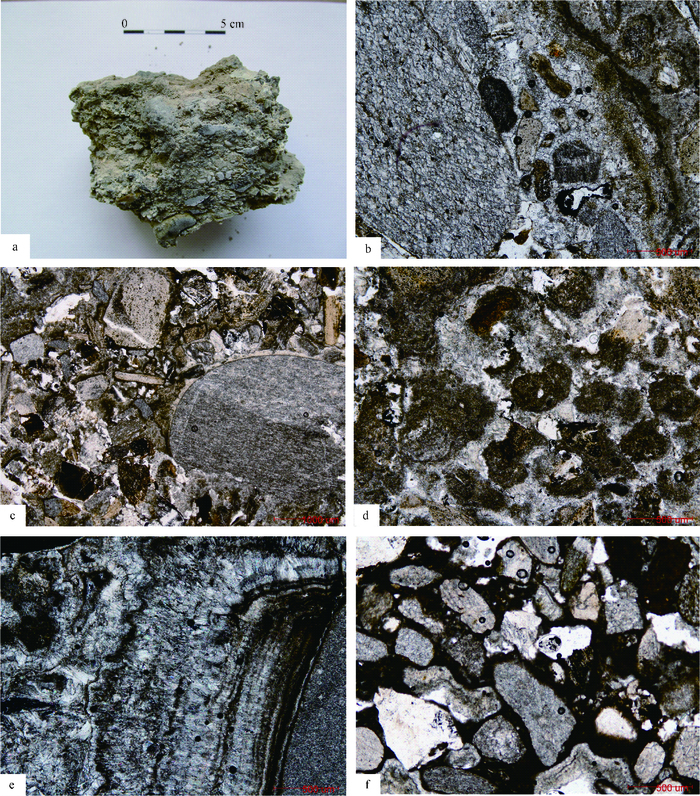
赛里木湖周缘湖滩岩的显微特征显示,该区湖滩岩是典型的方解石胶结砂屑砾屑岩,块状构造,基底式及接触式胶结(见图 4a、4b)。岩石主要由内碎屑、藻团块、陆源碎屑、胶结物和泥晶填隙物等构成。内碎屑由粉泥晶灰岩、粉晶灰岩、钙板岩、细晶灰岩、粉细晶白云岩、单晶方解石、单晶白云石等构成,碎屑呈次棱角—圆状,略显方向性,内碎屑以2.0~30.0 mm的砾级屑(30%~50%)为主,少量(10%~30%)砂级碎屑(0.1~2.0 mm,见图 4c)。藻团块呈不规则团状,由泥晶方解石及藻类(见图 4d)构成,有的似纹层状与亮晶方解石相间排列而构成玛瑙纹构造(见图 4e)。陆源碎屑(10%~20%)由岩屑及少量石英构成,次棱角—棱角状,零散显方向性分布,主要为硅质岩、石英岩,大小0.05~15.00 mm不等,而湖滩岩的胶结物(10%~15%)主要由亮晶方解石及少部分文石构成。部分湖滩岩可见粒径小于0.01 mm的泥晶填隙物(见图 4f),个别湖滩岩还含有少量被方解石填充的腕足类生物碎屑,并偶见海百合生物碎屑。湖滩岩的胶结物多由呈清晰纤状、刃状的亮晶方解石和文石构成。
 图 4 赛里木湖周缘湖滩岩显微特征a—湖滩岩手标本,可观察到其结构为典型的砂质含砾胶结岩,块状构造,接触式胶结;b—镜下观察湖滩岩薄片,岩石为含砂砾质砂屑砾屑结构(-),基底式接触式胶结。内碎屑由泥晶灰岩、粉晶灰岩等构成,次棱角—浑圆状,具方向性分布。陆源碎屑由岩屑、石英构成。岩屑主见硅质岩、石英岩、(含铁炭质)粘土质板岩、花岗斑岩、蚀变岩等,大小不等。胶结物由亮晶方解石及少量文石构成,粒径<0.1mm。亮晶方解石、文石主呈纤状、刃状等;c—镜下观察湖滩岩薄片,岩石由内碎屑、藻团块、藻球粒、陆源碎屑、填隙物构成。陆源碎屑由岩屑、石英构成,棱角-次棱角状为主,零散分布。岩屑主见硅质岩、石英岩、粘土质板岩等,大小0.02~8.0 mm不等;d—镜下观察湖滩岩样品中的藻团块特征。藻团块呈团状,有的边缘不规则,0.2~1.0 mm,由泥晶方解石及藻类构成,色暗;e—镜下观察湖滩岩胶结物特征,胶结物由亮晶方解石及少量文石构成,亮晶方解石、文石主要呈纤状、刃状等,垂直碎屑生长,构成栉壳结构,局部由多层纤状方解石与有机质混杂构成玛瑙纹状构造,基底式及接触式胶结;f—镜下观察湖滩岩的泥晶填隙物。湖滩岩中的内碎屑及陆源碎屑之间的填隙物由亮晶方解石胶结物、文石及泥晶方解石填隙物构成Figure 4. Micro-characteristics of the lacustrine-beach rock around south-east Sayram Lake
2.2 矿物学特征
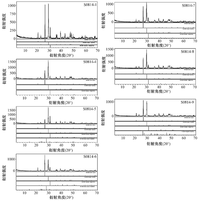
湖滩岩的成岩机制及其蕴含的古环境信息,可通过对胶结物成分的分析来进行。对赛里木湖湖滩岩样品经X射线衍射定量分析表明,该区湖滩岩的胶结物主要由方解石(30%~45%)、白云石(20%左右)和少量的文石(<2%)组成(见图 5)。同时,鉴定测得少量石英和长石成分,可能是由于少量的石英和长石等局部混入胶结物造成的。
 图 5 湖滩岩胶结物X射线衍射图谱Ca—普通方解石(含镁);Q—石英;Do—白云石;Ab—钠长石Figure 5. The X-ray diffraction gram of the lacustrine-beach rock cement
湖滩岩是在湖水作用下胶结形成的,这类岩石的初始胶结物通常为赛里木湖水中经常形成的文石和高镁方解石。有国外研究者指出,胶结物的矿物组成取决于孔隙中的Mg2+浓度,在Mg2+/Ca2+比值较高的环境里,胶结物通常为较不稳定的高镁方解石或文石[8~9]。文石是一种不稳定的含钙镁碳酸盐矿物,在表生环境中容易转变成方解石。当赛里木湖湖面发生下降时,湖滩岩脱离湖水环境,岩石暴露于表生环境中,受到大气降水或地下水影响发生新生变形(Neomorphism),使得最初的胶结物由亚稳定的高镁方解石或文石发生退变,原先胶结的文石在后期逐渐转变成为含镁低的方解石(普通方解石),使得湖滩岩胶结物中的文石含量很少。
综合分析可知,赛里木湖周缘发现的湖滩岩均是湖滨相的粗粒碎屑经碳酸盐胶结而形成的沉积岩。这些湖滩岩固结程度良好,与其下伏湖滨相松散沉积物呈逐渐过渡接触关系,湖滩岩的碎屑成分与湖滨松散沉积物相同,这与前人对此类岩石的研究结果[3, 10~13]基本一致。
3. 湖滩岩U系测年及形成年代分析
为进一步探明湖滩岩的形成时代,沿赛里木湖东南部3个实测湖岸剖面采集了3个湖滩岩样品和1个覆盖在高湖岸阶地后缘洪积扇顶部的钙质胶结砂砾岩样品,并采用铀系不平衡测年方法进行了年代学测试分析。其中的湖滩岩样品分别采集于赛里木湖东三台乌伊公路北侧附近最高湖岸堤的顶部,以及湖东南岸7~9 m高程的湖岸阶地顶部,洪积相的钙质胶结砂砾岩样品采自拔湖38~40 m洪积扇顶部。4个样品的拔湖高度与岩性见表 1。
表 1 赛里木湖湖滩岩出露高程及铀系测试结果Table 1. Elevations and U-series dates of the lacustrine-beach rock around the Sayram Lake样品编号 剖面地点与采样部位 拔湖高度/m 高程/m 岩性 年龄/ka S0811-7 S1剖面最高湖岸堤顶部 34.72 2107 钙质胶结砂砾石 55.4±3.8 S0814-5 S7剖面第9测点小湖岸堤顶 9.38 2082 钙质胶结砾石 27.6±1.5 S0814-9 湖岸阶地后缘上覆洪积扇前缘 44.85 2118 钙质胶结含砂砾石 37.0±2.2 S0814-17 S8剖面2080 m湖岸堤顶部 7.14 2080 钙质胶结砾石 24.8±1.5 U系年代学测试中将湖滩岩样品物质视为自然形成的未受到重结晶作用影响的纯碳酸盐,对这些样品直接进行234U/238U和230Th/234U比值的测试[14],并以GBW04412作为U系年龄标准物质,将其作为标样参考值与样品的测试结果进行对比。测试过程为:首先将野外采集的方解石样品表面清污并研磨至小于150 μm(100目),再经过溶解、U和Th放射性物质的化学分离与纯化以及α谱测量,最后根据测得的238U、234U、230Th和232Th放射性活度值,计算出234U/238U、230Th/234U和230Th/232Th比值与误差,将其代入ISOPLOT程序获得样品的年龄值。经过处理的样品年龄测定数据见表 1。赛里木湖沿岸的3个湖滩岩的U系全溶样品年龄测定结果表明,其U系年龄呈现自拔湖较高向较低处由老变新的特点,表明年龄结果与地貌部位的相对新老相吻合,说明测试结果是相对可靠的。
根据样品的U系测年结果可以初步确定,赛里木湖自拔湖高度7.14 m以上,位于第一级湖岸阶地与第二级湖岸阶地之间的地貌部位的高位湖相沉积,形成于距今24.8±1.5~27.6±1.5 ka间的晚更新世晚期,大致相当于深海氧同位素MIS3(距今56~25 ka)的晚期。拔湖高度34.72 m的高湖积阶地和最高湖岸堤,则大致形成于距今55.4±3.8 ka的MIS3的早期。而在湖南部S7剖面上,年龄为距今37.0±2.2 ka的洪积扇覆盖于高湖积台地后缘(该洪积扇的中下部可能与湖积台地呈相变关系),这也指示高湖积台地上的湖滩岩年龄应该老于MIS3的中期,即形成于MIS早期。
4. 讨论
湖岸带受到水陆交互作用的影响,能够对环境变化迅速响应。而湖滩岩与形成于潮间带上的湖岸堤类似,都是在湖泊整体退缩过程中湖面保持相对稳定阶段,在水陆交互作用下沿湖岸带所形成的沉积记录。由于湖滩岩成岩于潮间带上,且成岩过程迅速,并多直接构成古湖岸线的一部分,出露位置可以指示与它形成同期的平均湖面位置,是指示古湖面的直接标志,其年龄也可近似代表相同高度上古湖岸线的时代。因此,可利用对湖滩岩的研究来揭示过去相对湖面变化的特征,一直是研究湖岸带变迁过程以及相关的气候环境意义的重要标志[15~20]。在赛里木湖地区高、低两级湖积台地上新发现的湖滩岩,显然指示了该区最近两次显著的高湖面阶段和随后的湖面下降过程。湖滩岩样品的U系年代学测试结果表明,它们主要形成于距今24.8±1.5 ka至27.6±1.5 ka和距今55.4±3.8 ka左右的MIS3阶段。因此,属于末次冰期MIS3间冰阶湖面变化过程的重要沉积记录。
距今59~29 ka(或56~25 ka)的深海氧同位素第3阶段(MIS3) 是末次冰期中气候相对暖湿的特殊时期(也称“末次间冰阶”),并具有全球性意义[21~22]。当时的全球气温普遍升高,平均气温比现今可高出3~4 ℃,大陆冰盖显著退缩,山地冰川融化,海平面上升[23]。该期气候变化在中国中—西部的冰芯、黄土、湖泊和沼泽泥炭等多种不同来源的气候记录中都有明显显示,并可进一步划分出多个冷、暖变化阶段[23~27]。如施雅风等[26]根据青藏高原的古里雅冰芯记录在MIS3阶段进一步划分出了a、b、c等3个亚阶段,其中3c(早期)与3a(晚期)为2个明显的暖期,温度分别高出现代3 ℃和4 ℃。陈一萌等[24]对黄土高原西部临夏塬堡剖面的研究表明,末次冰期大间冰阶的MIS3可划分为距今56.1~42.2 ka强温湿、距今39.3~33.1 ka弱温湿与距今31~25 ka中等温湿3个温湿期和其间距今42.2~39.3 ka与距今33.1~31.0 ka的2个干冷期。李世杰等[25]对青藏高原西北部甜水海盆地湖泊沉积岩心的研究表明,甜水海分别在MIS3时期距今59~56 ka、49~47 ka、45~41 ka、35.5~34.0 ka和28~25 ka期间存在高湖面,并认为高湖面的出现与气候变暖导致的冰川融水增加或气候变湿造成的降水增加有关。朱芸等[27]对神农架沼泽泥炭沉积的环境气候指标研究结果显示,该区在MIS3阶段的早期(距今60~49 ka)和晚期(距今38.5~26.1 ka)存在大气湿度明显增高和气温升高现象。
上述研究表明,MIS3阶段的早期和晚期,在中国不同的气候区都存在比较较明显的高温高降水气候特征,这一气候特点显然有利于处于西北干旱区天山腹地中的古湖泊出现相对稳定的高湖面阶段。赛里木湖周缘高、低两级湖积台地上的湖滩岩年龄表明,在MIS3的早、晚期,赛里木湖先后出现了高湖面,并保持稳定了较长的时间,为湖滩岩的发育创造了条件。因此,可以说赛里木湖高湖面的出现是MIS3阶段暖湿气候特点的结果。遥感解译和地表调查也发现,赛里木湖盆地周缘山地在末次冰期都曾不同程度地发育古冰川,特别是西部山地,至今还有小规模现代冰川残留。因此,MIS3阶段早、晚期的暖湿气候,会造成山地冰川融化,并发生显著退缩,再加上相对充沛的降水,可为湖泊提供充足的水源供应,从而使得湖泊的水源供给大于或等于湖水的蒸发量,形成高湖面并保持湖面稳定。除了最为显著的高、低两级湖积台地,在赛里木湖周缘还发育多道古湖岸堤和湖岸阶地,它们的存在表明,在MIS3期间和之后,赛里木湖还经历了多个湖面波动过程,反映了该区还存在多个次一级的冷暖气候变化过程。另外,从赛里木湖的湖岸阶地和湖岸堤发育特点不难看出,该区MIS3阶段早期的高湖面是范围最大的,也是保持时间相对最长的,之后的湖泊整体上处于不断退缩过程中,这也与该区末次冰期以来冰川规模不断退缩的过程是吻合的,都反映了西天山地区在MIS3以来气候不断干旱化的趋势。但在区域气候不断干旱化过程中,仍存在多个相对暖湿的气候阶段,使得湖面能够得以保持相对稳定或略有上升,从而形成了高湖积台地之后的多个阶地和多道规模不等的古湖岸堤。如能对这些阶地和湖岸堤的发育特点及时代做进一步研究,将有助于更深入地了解该区在MIS3以来的湖面变化过程和相关气候环境演化特征。
5. 结论
赛里木湖的湖滩岩是湖滨相粗粒碎屑经碳酸盐胶结而形成的沉积岩,是在湖泊整体退缩过程中湖面保持相对稳定阶段,在水陆交互作用下沿湖岸带所形成的沉积记录,也是指示古湖面的直接标志。
赛里木湖最近一期最高湖面出现在距今55.4 ka左右末次间冰阶早期,可高出现今湖面35~40 m,高湖面的出现与MIS阶段气候变暖湿密切相关。
最近一次相对稳定的高湖面期出现在MIS3阶段的末期,仅高出现今湖面7~9 m左右,随后的末次盛冰期可能造成了湖面。
赛里木湖在MIS3阶段以来整体处于湖面逐步降低的过程中,反映了该区气候的逐步干旱化趋势,但在期间存在多次气候相对暖湿期,并造成湖面相对扩张或稳定,并可形成湖滩岩沉积记录。
-
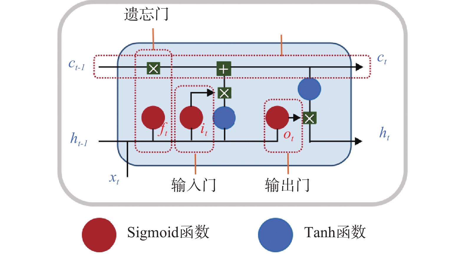
图 2 LSTM网络结构
注:ht-1—上一时刻的输出;ht—当前时刻的输出;ct-1—上一时刻状态;ct—当前状态;xt—当前输入;it—输入门;ft—遗忘门;ot—输出门
Figure 2. LSTM network architecture
Note:ht-1−output of previous moment; ht−output of current moment; ct-1−previous-moment-status; ct−current status; xt−current input; it−input gate; ft−forget gate; ot−output gate.

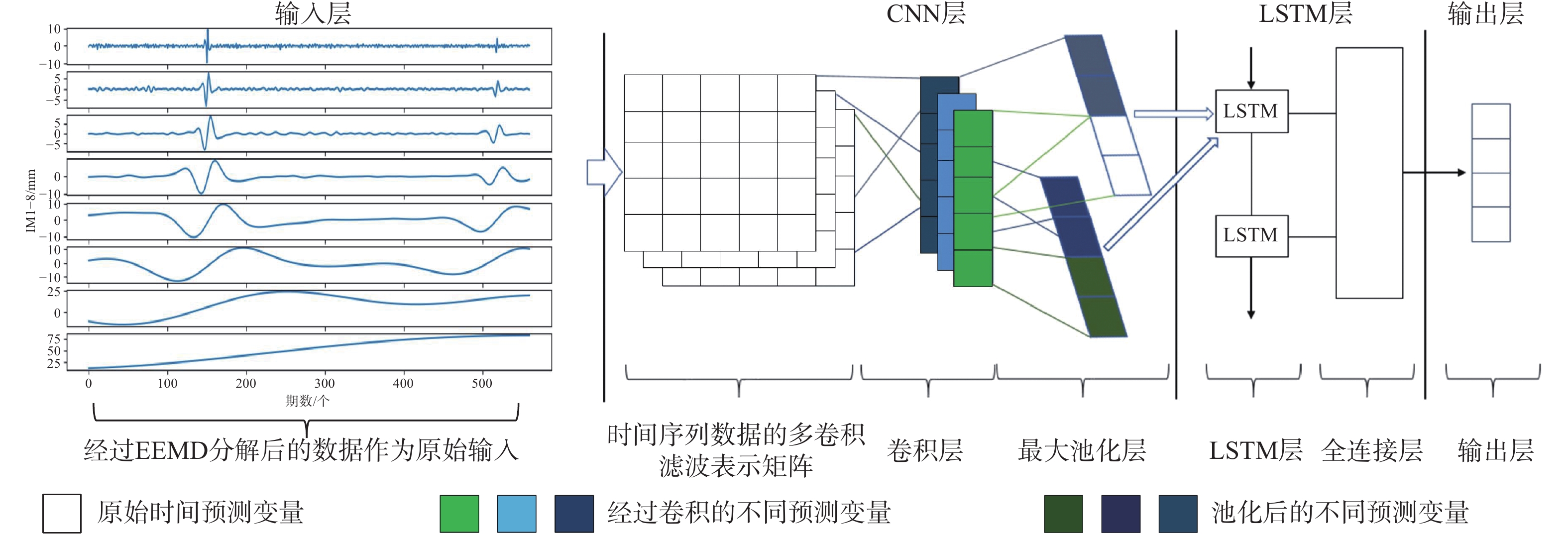
图 3 基于EEMD-CNN-LSTM模型的滑坡位移预测流程图
Figure 3. Flow chart of landslide-displacement prediction based on EEMD-CNN-LSTM model
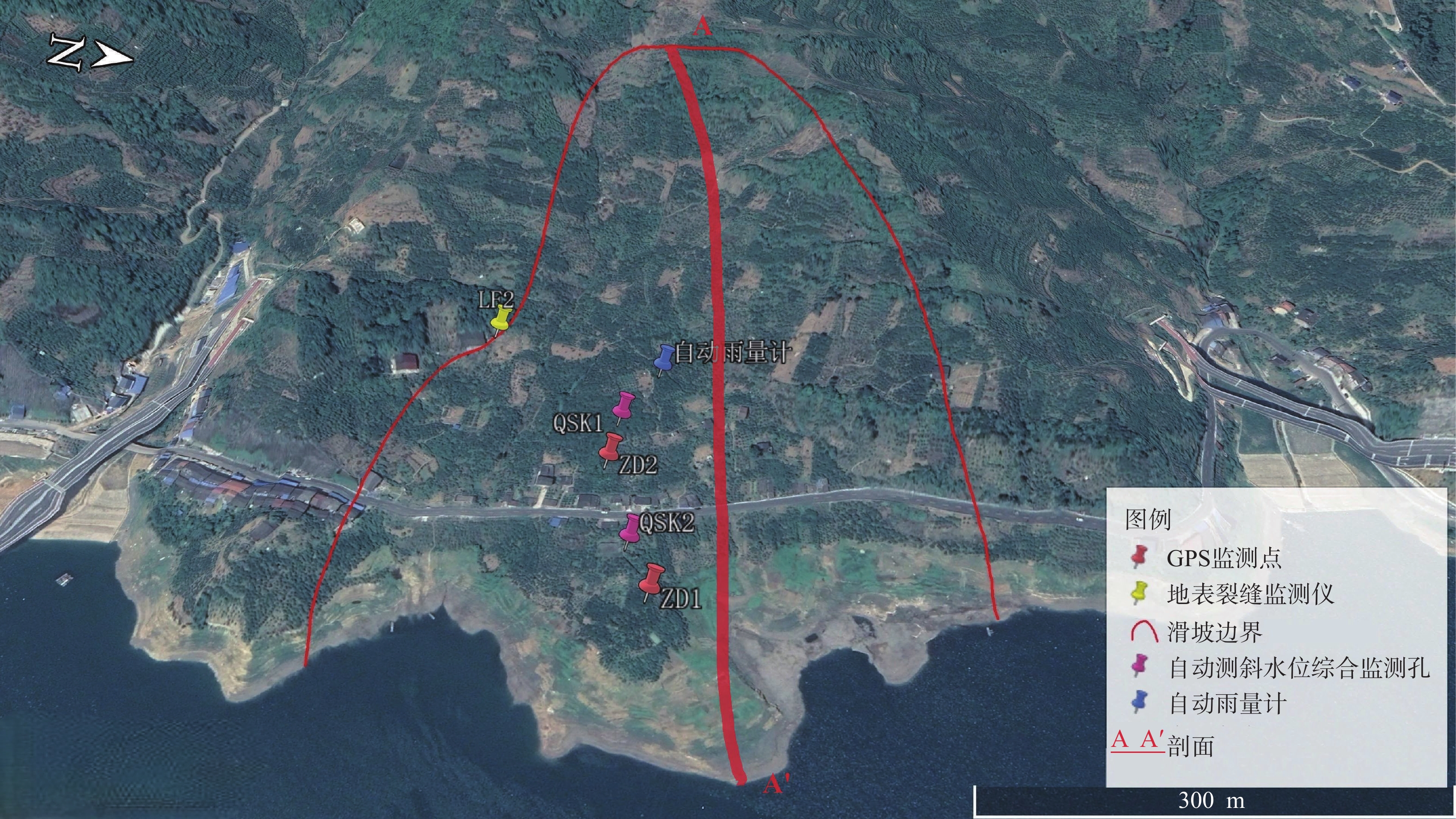
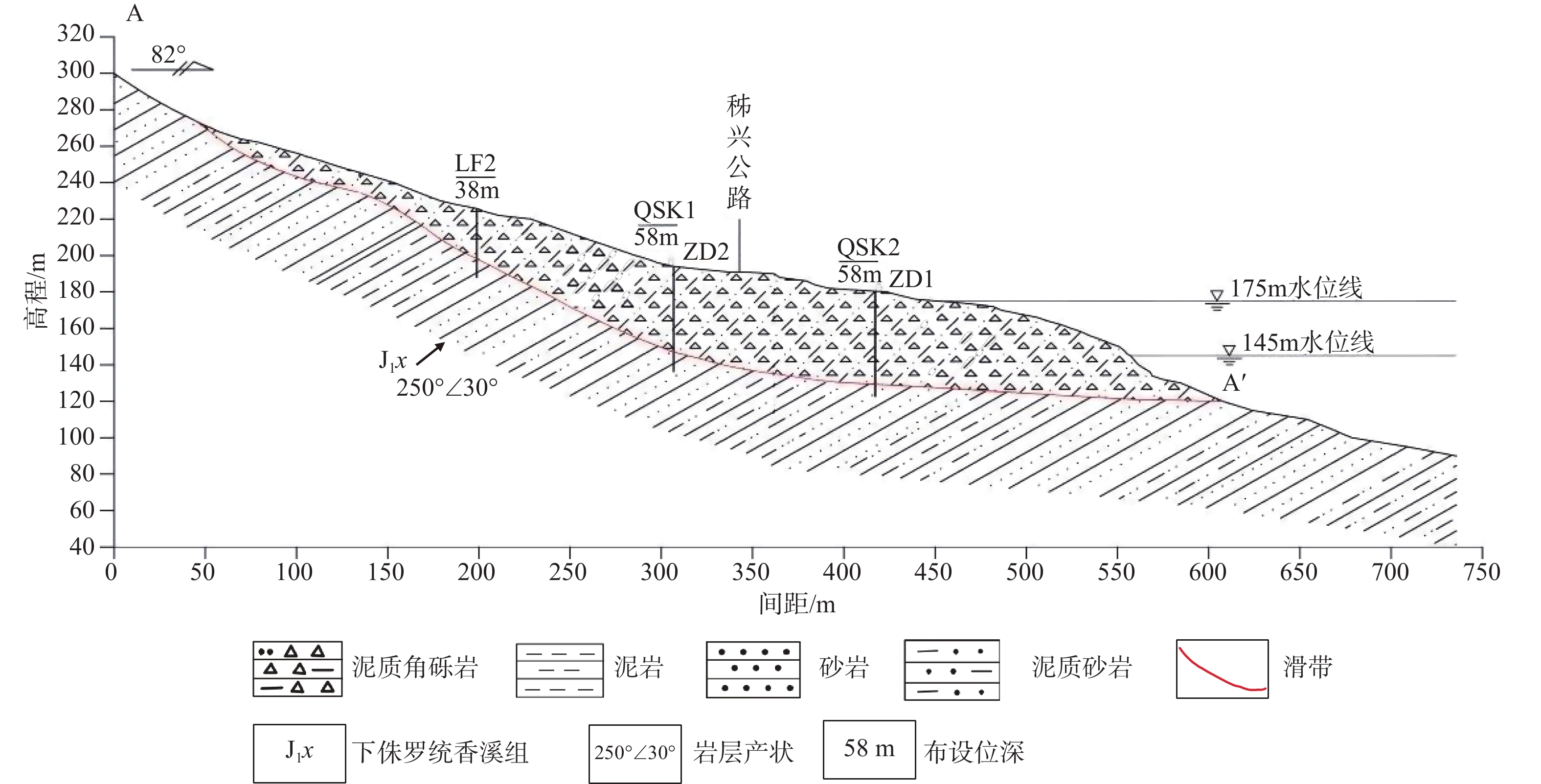
图 4 白家包滑坡及布设点位示意图
Figure 4. Schematic illustration of Baijiabao landslide and laying point
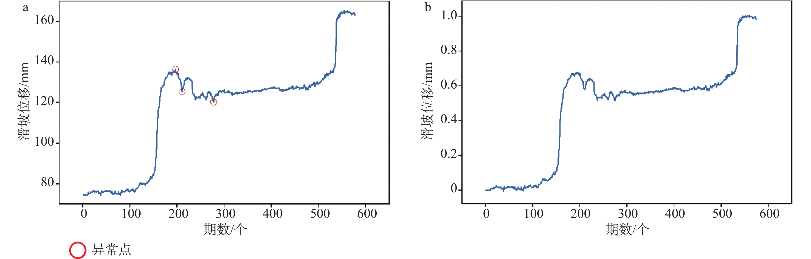
图 6 数据预处理
a—异常值检测;b—异常值剔除
Figure 6. Data preprocessing:
(a) Outlier detection; (b) Outlier culling

图 7 EMD与EEMD模型的分解结果对比
a—EMD模型;b—EEMD模型
Figure 7. Comparison of decomposition results between EMD and EEMD:
(a) EMD model; (b) EEMD model
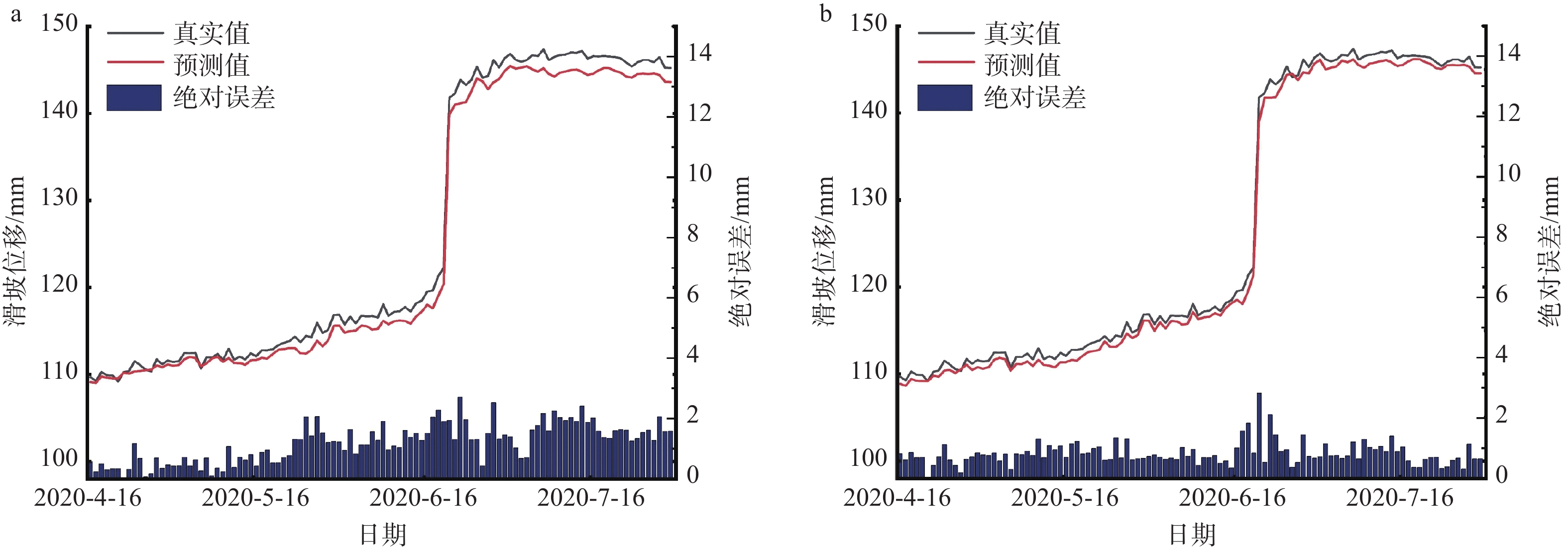
图 8 EEMD-CNN-LSTM模型对滑坡位移趋势项的预测结果
a—降雨情况下;b—无降雨情况下
Figure 8. Prediction results of EEMD-CNN-LSTM model for displacement-trend terms of landslide:
(a) With rainfall; (b) Without rainfall
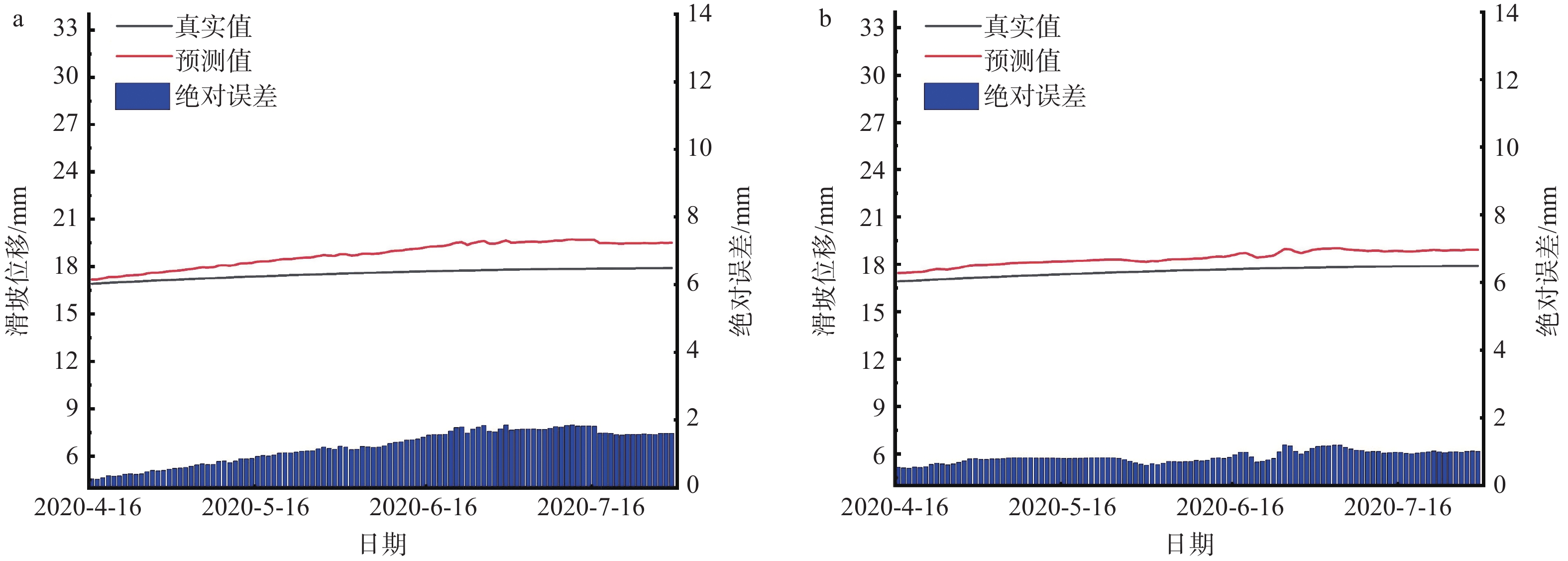
图 9 EEMD-CNN-LSTM模型对滑坡位移周期项的预测结果
a—降雨情况下;b—无降雨情况下
Figure 9. Prediction results of EEMD-CNN-LSTM model for landslide-periodic displacement:
(a) With rainfall; (b) Without rainfall
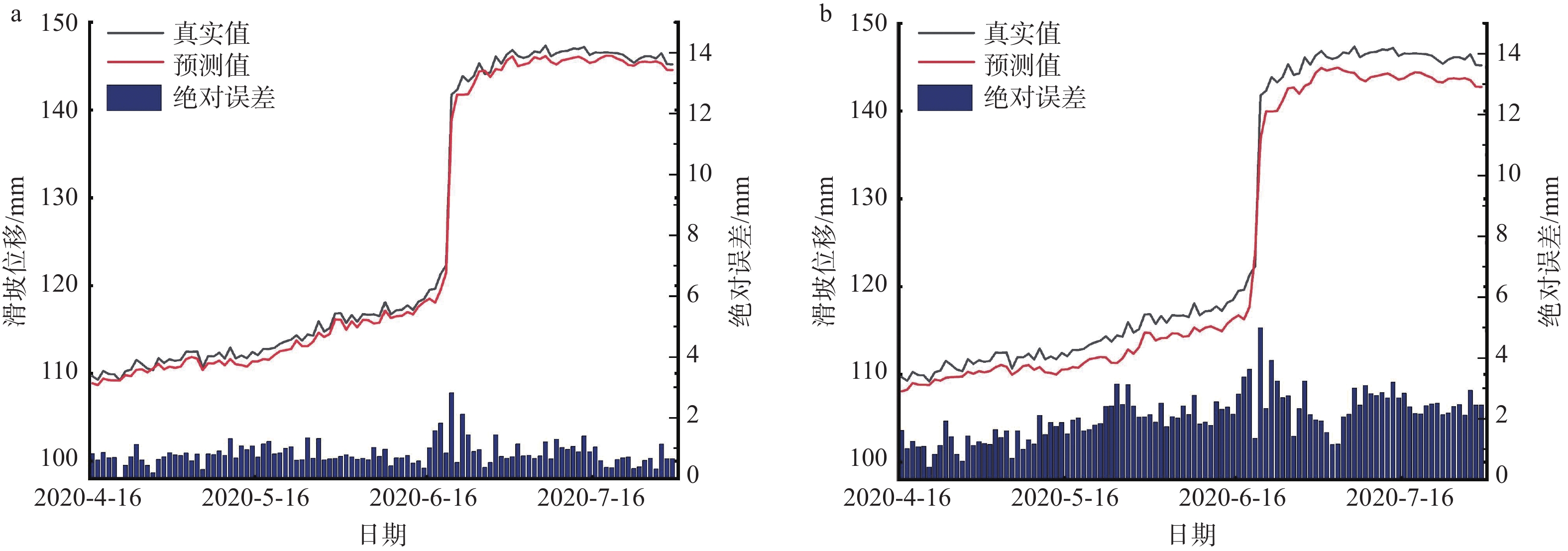
图 10 EEMD-CNN-LSTM模型与EEMD-LSTM模型对滑坡位移趋势项预测结果对比
a—EEMD-CNN-LSTM模型;b—EEMD-LSTM模型
Figure 10. Prediction results of EEMD-CNN-LSTM and EEMD-LSTM models for displacement-trend terms of landslide:
(a) EEMD-CNN-LSTM model; (b) EEMD-LSTM model
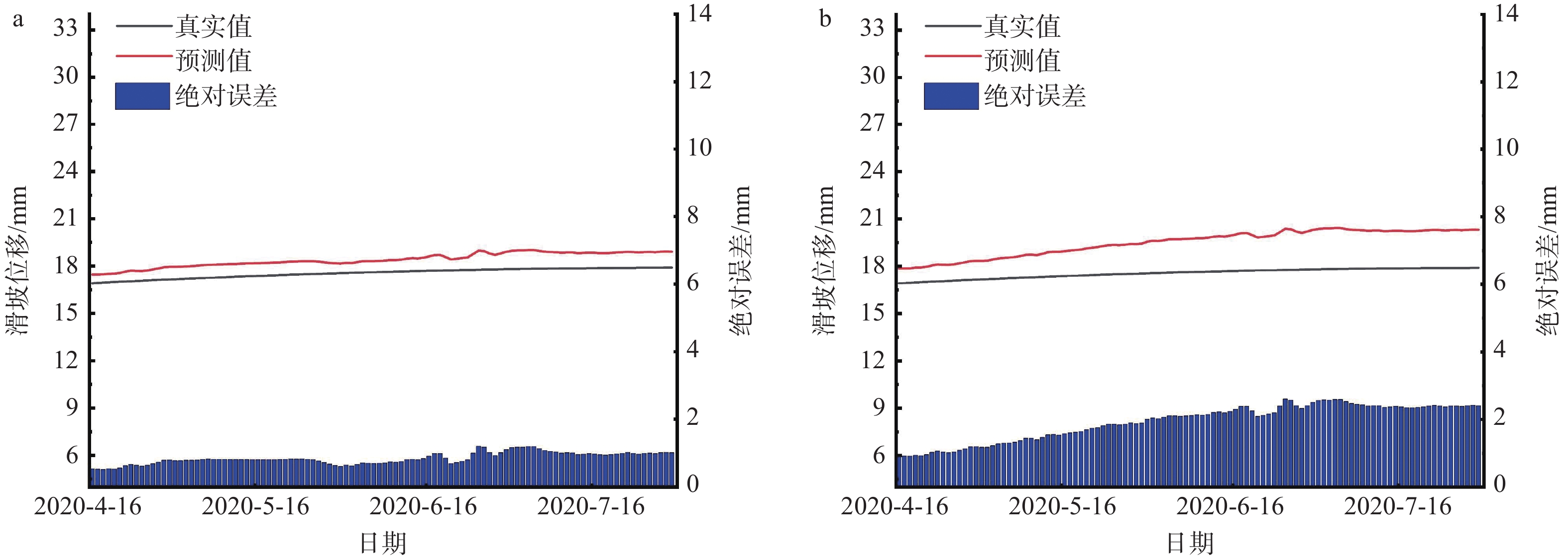
图 11 EEMD-CNN-LSTM模型与EEMD-LSTM模型对滑坡位移周期项预测结果对比
a—EEMD-CNN-LSTM模型;b—EEMD-LSTM模型
Figure 11. Prediction results of EEMD-CNN-LSTM and EEMD-LSTM models for landslide periodic displacement
(a) EEMD-CNN-LSTM model; (b) EEMD-LSTM model
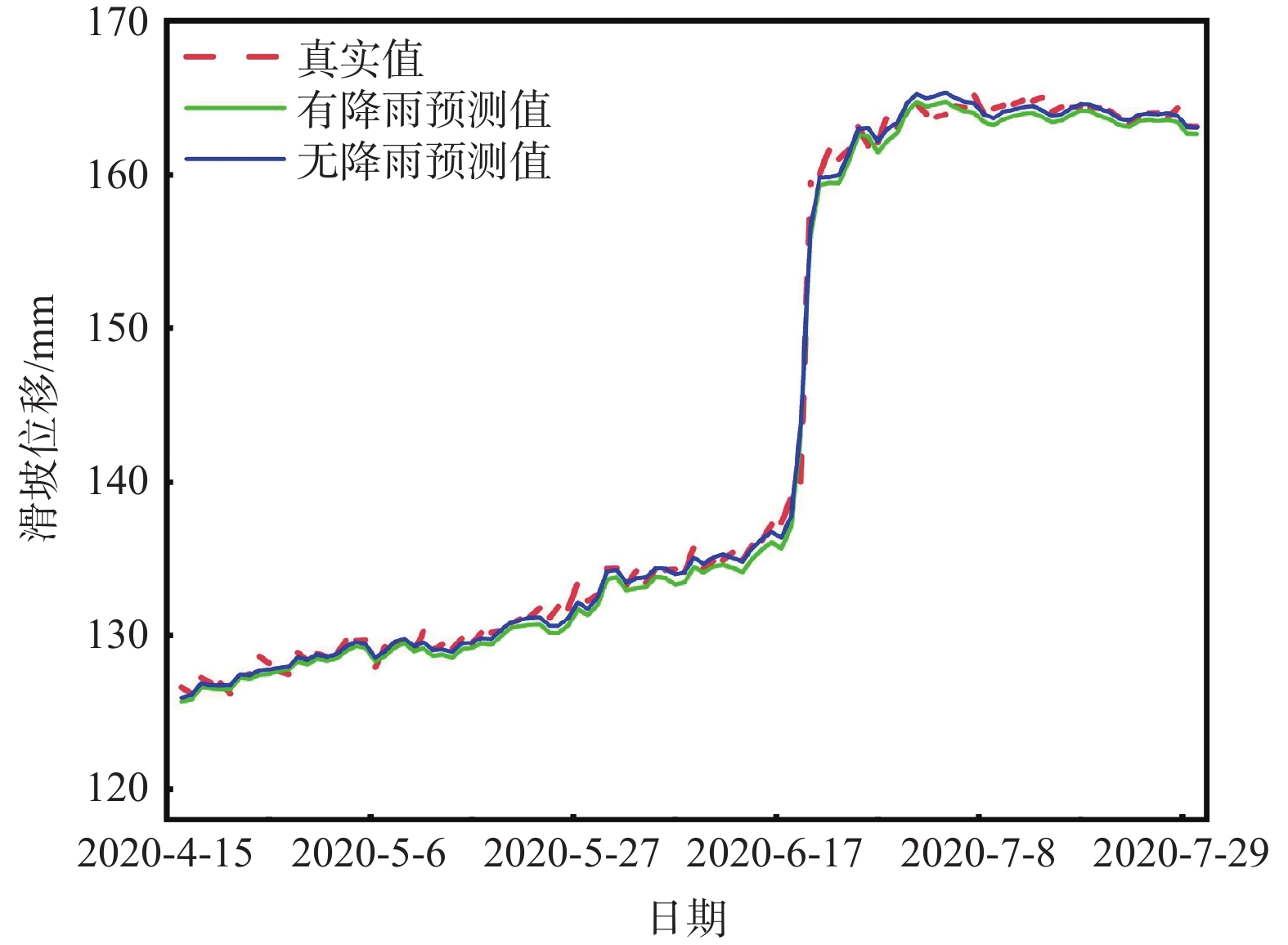
图 12 EEMD-CNN-LSTM模型对白家包滑坡位移预测结果
Figure 12. Landslide-displacement prediction results of EEMD-LSTM model
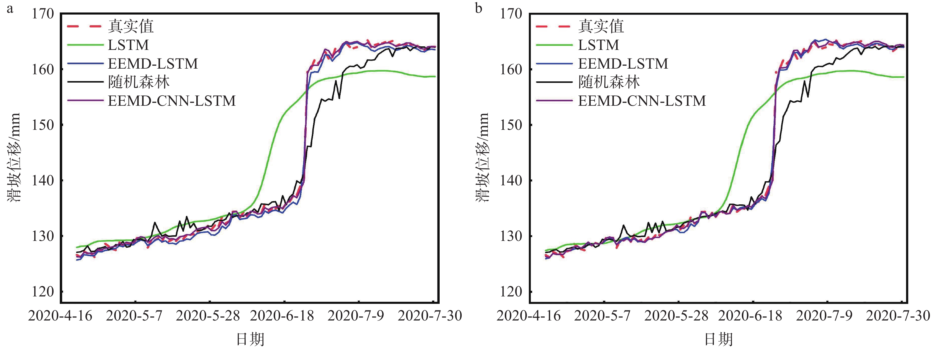
图 13 EEMD-CNN-LSTM模型、EEMD-LSTM模型和LSTM模型以及随机森林模型对滑坡位移预测结果与真实值的对比(ZD1监测点)
a—有降雨情况下;b—无降雨情况下
Figure 13. Prediction results of EEMD-CNN-LSTM, EEMD-LSTM, LSTM, and random-forest models for ZD1
(a) With rainfall; (b) Without rainfall
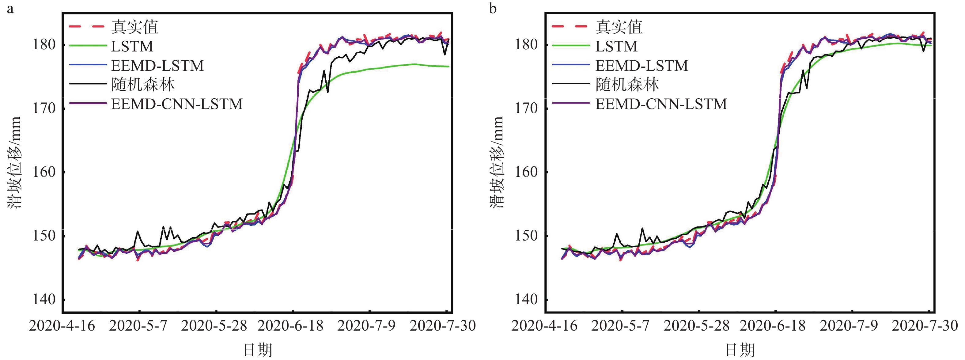
图 14 EEMD-CNN-LSTM模型、EEMD-LSTM模型、LSTM模型和随机森林模型对滑坡位移预测结果与真实值的对比(ZD2监测点)
a—有降雨情况下;b—无降雨情况下
Figure 14. Prediction results of EEMD-CNN-LSTM, EEMD-LSTM, LSTM, and random-forest models for ZD2
(a) With rainfall; (b) Without rainfall
表 1 ZD2监测点EEMD-CNN-LSTM模型、EEMD-LSTM模型、LSTM模型和随机森林模型对滑坡位移预测结果的性能评价
Table 1. Performance evaluation of ZD2 prediction results for EEMD-CNN-LSTM, EEMD-LSTM, LSTM, and random-forest models (with/without rainfall)
模型类型 RMSE/mm MAE/mm MAPE/% R2 EEMD-CNN-LSTM 0.4302/0.4190 0.2908/0.3139 0.2431/0.2379 0.9996/0.9997 EEMD-LSTM 0.6249/0.6187 0.4259/0.4193 0.2642/0.2567 0.9983/0.9983 LSTM 1.9925/3.4102 1.3365/2.7297 0.7888/1.5778 0.9812/0.9449 随机森林 0.8391/1.0329 0.6365/0.7316 0.5078/0.5762 0.9890/0.9885 注:“/”前为降雨下的结果;“/”后为无降雨下的结果  下载: 导出CSV
-
[1] AN D, SONG K, YI Z, et al., 2021. A prediction model for reservoir landslide step-like displacements using combined EEMD and RFR method[J]. Mountain Research, 39(1): 143-150. (in Chinese with English abstract [2] BINIYAZ A, AZMOON B, SUN Y, et al., 2022. Long short-term memory based subsurface drainage control for rainfall-induced landslide prevention[J]. Geosciences, 12(2): 64. doi: 10.3390/geosciences12020064 [3] FENG Y, ZENG H N, TU P F, 2023. A time series decomposition method for landslide displacement based on sliding detection algorithm[J]. Journal of Changjiang River Scientific Research Institute, 41(3): 126-133, 147. (in Chinese with English abstract [4] FU W T, HU D M, WANG S H, et al. , 2020. Landslide displacement prediction based on EEMD-GM-ELM model[C]//Proceedings of the 11th China satellite navigation annual conference: S01 satellite navigation industry application. Beijing: Academic Exchange Center of China Satellite Navigation System Management Office: 89-93. (in Chinese with English abstract [5] HAN S, LIU M J, WU J B, et al., 2022. Risk assessment of slope disasters induced by typhoon-rainfall in the southeast coastal area, China: A case study of the Shiyang north slope[J]. Journal of Geomechanics, 28(4): 583-595. (in Chinese with English abstract [6] HARIRI S, KIND M C, BRUNNER R J, 2021. Extended isolation forest[J]. IEEE Transactions on Knowledge and Data Engineering, 33(4): 1479-1489. doi: 10.1109/TKDE.2019.2947676 [7] JIANG H W, LI Y Y, ZHOU C, et al., 2020. Landslide displacement prediction combining LSTM and SVR algorithms: a case study of Shengjibao landslide from the three gorges reservoir area[J]. Applied Sciences, 10(21): 7830. doi: 10.3390/app10217830 [8] KANG E S, ZHAO Z X, MENG H D, 2022. Displacement prediction of dump slope based on EEMD-HW-PSO-ELM coupling model[J]. Gold Science and Technology, 30(4): 594-602. (in Chinese with English abstract [9] KATTENBORN T, LEITLOFF J, SCHIEFER F, et al., 2021. Review on Convolutional Neural Networks (CNN) in vegetation remote sensing[J]. ISPRS Journal of Photogrammetry and Remote Sensing, 173: 24-49. doi: 10.1016/j.isprsjprs.2020.12.010 [10] KRKAČ M, ŠPOLJARIĆ D, BERNAT S, et al., 2017. Method for prediction of landslide movements based on random forests[J]. Landslides, 14(3): 947-960. doi: 10.1007/s10346-016-0761-z [11] Aggarwal A, Alshehri M, Kumar M, et al., 2020. Landslide data analysis using various time-series forecasting models[J]. Computers & Electrical Engineering, 88: 106858. [12] LEI Y G, LIN J, HE Z J, et al., 2013. A review on empirical mode decomposition in fault diagnosis of rotating machinery[J]. Mechanical Systems and Signal Processing, 35(1-2): 108-126. doi: 10.1016/j.ymssp.2012.09.015 [13] LI H J, XU Q, HE Y S, et al., 2018. Prediction of landslide displacement with an ensemble-based extreme learning machine and copula models[J]. Landslides, 15(10): 2047-2059. doi: 10.1007/s10346-018-1020-2 [14] LI L J, YAO X, ZHOU Z K, et al., 2022. The applicability assessment of Sentinel-1 data in InSAR monitoring of the deformed slopes of reservoir in the mountains of southwest China: A case study in the Xiluodu Reservoir[J]. Journal of Geomechanics, 28(2): 281-293. (in Chinese with English abstract [15] LIAN C, ZENG Z G, YAO W, et al., 2013. Displacement prediction model of landslide based on a modified ensemble empirical mode decomposition and extreme learning machine[J]. Natural Hazards, 66(2): 759-771. doi: 10.1007/s11069-012-0517-6 [16] LIU F T, TING K M, ZHOU Z H, 2008. Isolation forest[C]//2008 Eighth IEEE international conference on data mining. Pisa: IEEE: 413-422. [17] MA Y, YU B, HE Y X, et al., 2023. Rainfall Threshold and Development Characteristics of Shallow Landslides Induced by Rainfall: A Case Study of the "June 10th, 2019" Disaster in the Dajishan Area, Quannan County, Jiangxi Province[J]. Geology and Exploration, 59(5): 1065-1073. (in Chinese with English abstract [18] NAN X C, LIU J F, ZHANG Y X, et al., 2023. Dynamic prediction of landslide displacement based on multi-source time series[J]. Pearl River, 44(4): 54-62. (in Chinese with English abstract [19] PAK U, KIM C, RYU U, et al. , 2018. A hybrid model based on convolutional neural networks and long short-term memory for ozone concentration prediction[J]. Air Quality, Atmosphere & Health, 11(8): 883-895. [20] PENG L, NIU R Q, 2011. Analysis on deformation characteristics and influential factors of Baijiabao landslide in the Three Gorges Reservoir area[J]. The Chinese Journal of Geological Hazard and Control, 22(4): 1-7. (in Chinese with English abstract [21] QU J L, WANG X F, GAO F, et al., 2014. Noise assisted signal decomposition method based on complex empirical mode decomposition[J]. Acta Physica Sinica, 63(11): 110201. (in Chinese with English abstract doi: 10.7498/aps.63.110201 [22] SHANG M, XIONG D B, ZHANG H Q, et al., 2022. Landslide displacement prediction model based on time series and mixed kernel function SA-SVR[J]. Journal of Engineering Geology, 30(2): 575-588. (in Chinese with English abstract [23] SHI X L, HAN X D, YANG X Y, et al., 2023. Factors inducing the Xigouwan landslide in the Three Gorges Reservoir area and the influence of antecedent precipitation[J]. Journal of Geomechanics, 29(2): 253-263. (in Chinese with English abstract [24] SINGH P, KEYVANLOU M, SADHU A, 2021. An improved time-varying empirical mode decomposition for structural condition assessment using limited sensors[J]. Engineering Structures, 232: 111882. doi: 10.1016/j.engstruct.2021.111882 [25] SUN D L, CHEN D L, MI C L, et al., 2023. Evaluation of landslide susceptibility in the gentle hill-valley areas based on the interpretable random forest-recursive feature elimination model[J]. Journal of Geomechanics, 29(2): 202-219. (in Chinese with English abstract [26] SUN N K, WANG Y, JI Z C, 2022. Anomaly detection method of electrical power consumption based on deep autoencoder[J]. Journal of System Simulation, 34(12): 2557-2565. (in Chinese with English abstract [27] WANG C H, ZHAO Y J, GUO W, et al., 2022. Displacement prediction model of landslide based on ensemble empirical mode decomposition and support vector regression[J]. Acta Geodaetica et Cartographica Sinica, 51(10): 2196-2204. (in Chinese with English abstract [28] WANG Y K, TANG H M, HUANG J S, et al., 2022. A comparative study of different machine learning methods for reservoir landslide displacement prediction[J]. Engineering Geology, 298: 106544. doi: 10.1016/j.enggeo.2022.106544 [29] WU J N, 2021. Research on landslide geological disaster prediction method based on deep learning[D]. Chengdu: University of Electronic Science and Technology of China. (in Chinese with English abstract [30] WU Z H, HUANG N E, 2009. Ensemble empirical mode decomposition: a noise-assisted data analysis method[J]. Advances in Adaptive Data Analysis, 1(1): 1-41. doi: 10.1142/S1793536909000047 [31] XU S L, NIU R Q, 2018. Displacement prediction of Baijiabao landslide based on empirical mode decomposition and long short-term memory neural network in Three Gorges Area, China[J]. Computers & Geosciences, 111: 87-96. [32] XU Z H, YANG X, SUN Q C, et al. , 2022. Step-type landslide deformation prediction based on multivariable self-optimizing dynamic neural network[J]. Metal Mine(3): 74-82. (in Chinese with English abstract [33] YAN S J, TANG H M, XIANG W, 2007. Effect of rainfall on the stability of landslides[J]. Hydrogeology & Engineering Geology, 34(2): 33-36. (in Chinese with English abstract [34] YANG B B, YIN K L, DU J, 2018. A model for predicting landslide displacement based on time series and long and short term memory neural network[J]. Chinese Journal of Rock Mechanics and Engineering, 37(10): 2334-2343. (in Chinese with English abstract [35] YANG B B, YIN K L, LACASSE S, et al., 2019. Time series analysis and long short-term memory neural network to predict landslide displacement[J]. Landslides, 16(4): 677-694. doi: 10.1007/s10346-018-01127-x [36] YAO W M, LI C D, ZUO Q J, et al., 2019. Spatiotemporal deformation characteristics and triggering factors of Baijiabao landslide in three gorges reservoir region, China[J]. Geomorphology, 343: 34-47. doi: 10.1016/j.geomorph.2019.06.024 [37] YUAN W, SUN R F, ZHONG H Y, et al., 2023. Research on comprehensive deformation prediction and monitoring and early warning methods for step-type like landslide[J]. Journal of Hydraulic Engineering, 54(4): 461-473. (in Chinese with English abstract [38] ZHOU C, YIN K L, CAO Y, et al., 2018. A novel method for landslide displacement prediction by integrating advanced computational intelligence algorithms[J]. Scientific Reports, 8(1): 7287. doi: 10.1038/s41598-018-25567-6 [39] 安冬,宋琨,仪政,等,2021. 一种基于EEMD-RFR的水库滑坡台阶状位移预测模型[J]. 山地学报,39(1):143-150. [40] 冯谕,曾怀恩,涂鹏飞,2023. 一种滑动检测算法下的滑坡位移时序分解方法[J]. 长江科学院院报,41(3):126-133,147. [41] 付文涛,胡丁梅,王守华,等,2020. 基于EEMD-GM-ELM模型的滑坡位移预测[C]//第十一届中国卫星导航年会论文集:S01卫星导航行业应用. 北京:中国卫星导航系统管理办公室学术交流中心:89-93. [42] 韩帅,刘明军,伍剑波,等,2022. 东南沿海台风暴雨型单体斜坡灾害风险评价:以泰顺仕阳北坡为例[J]. 地质力学学报,28(4):583-595. doi: 10.12090/j.issn.1006-6616.2021168 [43] 康恩胜,赵泽熙,孟海东,2022. 基于EEMD-HW-PSO-ELM耦合模型的排土场边坡位移预测模型[J]. 黄金科学技术,30(4):594-602. [44] 李凌婧,姚鑫,周振凯,等,2022. Sentinel-1数据在西南山区水库变形斜坡InSAR监测中的适用性评价:以溪洛渡水库为例[J]. 地质力学学报,28(2):281-293. [45] 马 煜,余 斌,何元勋,等,2023. 降雨激发浅层滑坡发育特征与阈值研究:以江西省全南县大吉山“2019.6. 10”灾害为例[J]. 地质与勘探,59(5):1065-1073. doi: 10.12134/j.dzykt.2023.05.012 [46] 南骁聪,刘俊峰,张永选,等,2023. 基于多源时间序列的滑坡位移动态预测[J]. 人民珠江,44(4):54-62. [47] 彭令,牛瑞卿,2011. 三峡库区白家包滑坡变形特征与影响因素分析[J]. 中国地质灾害与防治学报,22(4):1-7. doi: 10.3969/j.issn.1003-8035.2011.04.001 [48] 曲建岭,王小飞,高峰,等,2014. 基于复数据经验模态分解的噪声辅助信号分解方法[J]. 物理学报,63(11):110201. doi: 10.7498/aps.63.110201 [49] 尚敏,熊德兵,张惠强,等,2022. 基于时间序列与混合核函数SA-SVR的滑坡位移预测模型研究[J]. 工程地质学报,30(2):575-588. [50] 史学磊,韩旭东,杨秀元,等,2023. 三峡库区溪沟湾滑坡的诱发因素及前期降雨影响[J]. 地质力学学报,29(2):253-263. doi: 10.12090/j.issn.1006-6616.2022049 [51] 孙德亮,陈丹璐,密长林,等,2023. 基于随机森林-特征递归消除模型的可解释性缓丘岭谷地貌滑坡易发性评价[J]. 地质力学学报,29(2):202-219. doi: 10.12090/j.issn.1006-6616.2022128 [52] 孙宁可,王艳,纪志成,2022. 基于深度自编码器的电力能耗异常检测方法[J]. 系统仿真学报,34(12):2557-2565. [53] 王晨辉,赵贻玖,郭伟,等,2022. 滑坡位移EEMD-SVR预测模型[J]. 测绘学报,51(10):2196-2204. doi: 10.11947/j.AGCS.2022.20220291 [54] 吴俊男,2021. 基于深度学习的滑坡地质灾害预测方法研究[D]. 成都:电子科技大学. [55] 徐志华,杨旭,孙钱程,等,2022. 基于多变量自优化动态神经网络的“阶跃型”滑坡变形预测[J]. 金属矿山(3):74-82. [56] 严绍军,唐辉明,项伟,2007. 降雨对滑坡稳定性影响过程分析[J]. 水文地质工程地质,34(2):33-36. doi: 10.3969/j.issn.1000-3665.2007.02.008 [57] 杨背背,殷坤龙,杜娟,2018. 基于时间序列与长短时记忆网络的滑坡位移动态预测模型[J]. 岩石力学与工程学报,37(10):2334-2343. [58] 袁维,孙瑞峰,钟辉亚,等,2023. 阶跃型滑坡综合变形预测及监测预警方法研究[J]. 水利学报,54(4):461-473. -

 下载:
下载:
 下载:
下载:

计量
- 文章访问数: 1084
- HTML全文浏览量: 209
- PDF下载量: 126
- 被引次数: 0
