

The impact of the Dagangshan Reservoir impoundment in Sichuan Province on the 2022 Luding MS 6.8 earthquake and its aftershocks
-
摘要: 2022年9月5日四川省泸定县发生MS 6.8地震,2023年1月发生MS 5.6余震。该次地震发生在鲜水河断裂南段,位于泸定地震震中东南部70 km的大岗山水库。该水库自建成蓄水后,引起库区北西侧磨西断裂的地震活动性显著变化:2014年11月水库达到预定水位之前的3年内,磨西段地震震级较小,多为0~2级微震;11月之后的3年内该区域地震震级和数量明显增加。文章利用高精度DEM数据、精准的地表断裂信息和地层地质信息,建立了三维孔隙弹性有限元数值模型,并根据震源机制解得到断层参数,定量计算了水库水位变化对地层孔隙压力、断层库仑应力的影响。在相关参数约束下的结果表明:水库蓄水造成MS 6.8地震震源位置在发震时刻的地层孔隙压力增加5 kPa,库仑应力增加3.6 kPa,对其发生具有一定促进作用。对于MS 5.6正断层型余震,水库蓄水造成其震源位置孔隙压力增加0.32 kPa,库仑应力降低0.69 kPa,对其所处断层面的滑动具有抑制作用。Abstract:
Objective The MS 6.8 earthquake that struck Luding County, Sichuan Province, on September 5, 2022, and its aftershocks have drawn widespread attention, especially concerning the potential risks of induced seismicity associated with the construction of high-dam reservoirs in regions with high seismic intensity. Previous studies have explored the possible link between reservoirs and seismic activity, without reaching a definitive conclusion. This study aims to assess the impact of water storage in the Dagangshan Reservoir on the surrounding strata and its correlation with recent seismic events. Methods Numerical simulation methods were employed using high-precision digital elevation model (DEM) data, fault data, and reservoir water level information to develop a three-dimensional poroelastic finite element numerical model extending from the surface to a depth of 25 km. By analyzing the hydrogeological conditions, lithology of rock masses, and groundwater dynamic changes, this study evaluated the seismic hazard risk of major faults, such as the Moxi Fault, and calculated variations in Coulomb stress and strata pore pressure at the hypocenter during the occurrence of the earthquake. Results The study indicates that, during the MS 6.8 Luding earthquake on September 5, 2022, the pore pressure at the epicenter reached 5 kPa, and the Coulomb stress increased by 3.6 kPa, suggesting that the impoundment of the Dagangshan Reservoir contributed to an increased risk along the Moxi Fault on the northwestern side of the reservoir. Using the source parameters of the MS 5.6 aftershock that occurred on January 26, 2023, it was observed that the impoundment caused a change in Coulomb stress at the epicenter of -0.69 kPa and a pore pressure of approximately 0.32 kPa. It is evident that the reservoir impoundment had a relatively minor impact on the fault activity where the MS 5.6 aftershock occurred and even exhibited a certain inhibitory effect. Moreover, seismic activity was mainly concentrated in two areas on the western side of the reservoir, with both the seismicity and expected magnitudes in these regions reflecting a higher risk of earthquakes. Conclusion This study demonstrates a correlation between the impoundment activities of the Dagangshan Reservoir and the occurrence of the Luding County earthquake and its aftershocks. The spatial distribution characteristics of the earthquakes align with the geological stress adjustment patterns following the reservoir impoundment, which played a promotive role in the occurrence of the MS 6.8 main shock, leading to an increased risk of earthquakes in the Moxi Fault region. This finding is significant for understanding the mechanisms of reservoir-induced earthquakes, subsequent aftershock analyses, and earthquake disaster prevention and mitigation efforts. Significance The results of this study provide new insights into the complex relationship between reservoir water storage and seismic events. This study offers a scientific basis for future assessments of seismic risks of reservoir design and operation, contributing to improved accuracy in earthquake early warnings and efficiency in disaster prevention and mitigation efforts. -

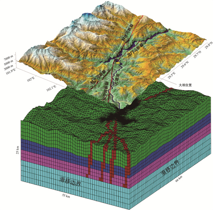
图 1 大岗山水库构造背景图
a—研究区构造背景图;b—研究区高程图
Figure 1. Tectonic background of the Dagangshan Reservoir
(a) Tectonic background of the study area; (b) Elevation map of the study area

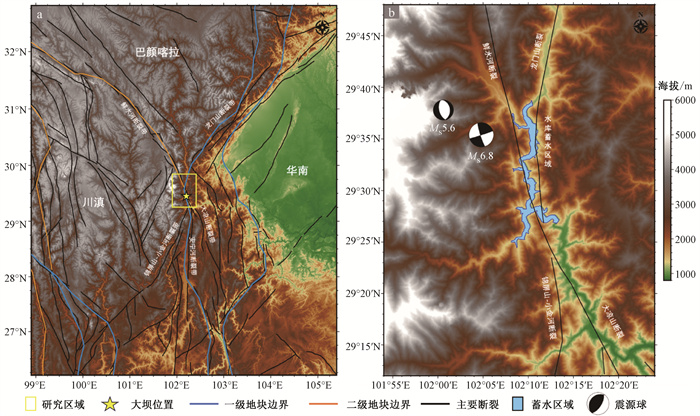
图 2 泸定MS 6.8地震的构造背景和余震分布(据Zhang et al., 2023修改)
图 2a中红色矩形表示图 2b的区域,蓝色和黄色椭圆分别表示1700年至1900年和1900年至今强震的地表破裂,区域上不同颜色代表不同构造单元,白色箭头表示构造块大致运动方向,一对黑色箭头表示鲜水河断裂带左旋运动,主要断裂用灰线表示,红线表示鲜水河断层,黑线和蓝线分别表示主要和次要块边界,箭头代表地块的移动方向;图 2b中震源球大小与震级正相关,两条黑色实线cut1和cut2代表图 6的剖面位置
a—泸定MS6.8地震的构造背景;b—余震分布Figure 2. Tectonic setting and aftershock distribution of the Luding MS 6.8 earthquake (modified from Zhang et al., 2023)
(a) Tectonic setting of Luding MS 6.8 earthquake; (b) Aftershock distribution
In Fig. 2a, the red rectangle represents the area shown in Fig. 2b; the blue and yellow ellipses respectively indicate surface ruptures of strong earthquakes from 1700 to 1900 and from 1900 to the present; different colors in the area represent different tectonic units; white arrows indicate the approximate movement direction of tectonic blocks; a pair of black arrows indicates left-lateral movement of the Xianshuihe fault zone; major faults are represented by gray lines; the red line represents the Xianshuihe fault; black and blue lines respectively represent the primary and secondary block boundaries; arrows denote the movement direction of blocks. In Fig. 2b, the size of the focal sphere is positively correlated with the magnitude of the earthquake; the two solid black lines cut1 and cut2 represent the position of the profile in Fig. 6.
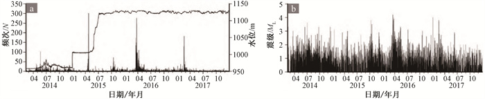
图 3 大岗山库区蓄水位与地震情况关系图(庄园旭等,2022)
a—大岗山库区N-T图;b—大岗山库区蓄水位与地震日频次关系图
Figure 3. Diagrams showing the relationship between water level in Dagangshan Reservoir and seismic activity(Zhuang et al., 2022)
(a)N-T plot of Dagangshan Reservoir; (b) Relationship between water level in Dagangshan Reservoir and daily seismic frequency

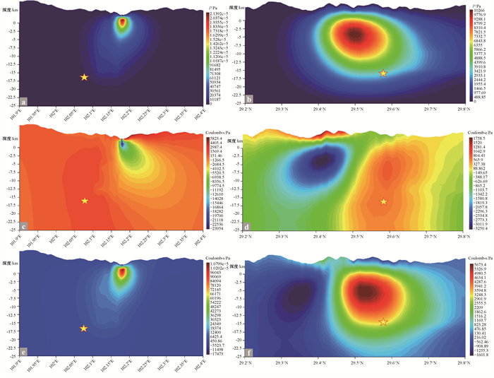
图 5 MS6.8泸定地震发震时刻16 km深度处孔隙压力和库仑应力平面分布图
黄色五角星代表震源位置,红色实线代表断裂,黑色实线包围区域为水库蓄水区域
a—孔隙压力分布;b—不考虑孔隙压力计算得到的震源深度处库仑应力;c—考虑孔隙压力计算得到的震源深度处库仑应力Figure 5. Plane distribution diagram of pore pressure and Coulomb stress at 15 km depth in the reservoir during the occurrence of the Luding MS 6.8 earthquake
(a)Distribution of pore pressure; (b) Coulomb stress at the hypocenter depth calculated without considering pore pressure; (c) Coulomb stress at the hypocenter depth calculated considering pore pressure
The yellow pentagon represents the hypocenter location, red solid lines represent the faults, and the black solid line encloses the reservoir storage area
图 6 MS 6.8泸定地震发震时刻震源位置的孔隙压力和库仑应力剖面分布图
a、c、e是以震源点的纬度线对模型的剖面cut1的结果图,b、d、f是以震源点的经度线对模型的剖面cut2的结果图,图中黄色五角星代表震源位置
a、b—孔隙压力分布;c、d—不考虑孔隙压力计算得到的库仑应力;e、f—考虑孔隙压力计算得到的库仑应力Figure 6. Profile distribution diagram of pore pressure and Coulomb stress at the hypocenter during the occurrence of the Luding MS 6.8 earthquake
(a, b) Distribution of pore pressure; (c, d) Coulomb stress calculated without considering pore pressure; (e, f) Coulomb stress calculated considering pore pressure
Figures a, c, and e represent the results of cross-sectional cut1 of the model along the latitude line of the hypocenter; b、d、f represent the results of cross-sectional cut2 of the model along the longitude line of the hypocenter. The yellow pentagon represents the hypocenter location
图 7 MS 6.8泸定地震震源位置的孔隙压力及库仑应力随水库水位变化图
Figure 7. Variation of pore pressure and Coulomb stress at the hypocenter of the Luding MS 6.8 earthquake with changes in reservoir water level

图 8 MS 5.6泸定地震余震发震时刻10 km深度处库仑应力平面分布图
图中黄色圆代表2022年9月至2023年1月3级以上余震的震源位置,红色圆代表主震震源位置,绿色圆代表MS 5.6余震震源位置,红色实线代表断裂,黑色实线包围区域为水库蓄水区域
a—孔隙压力分布;b—不考虑孔隙压力计算得到的库仑应力;c—考虑孔隙压力计算得到的库仑应力Figure 8. Plane distribution diagram of Coulomb stress at 10 km depth in the reservoir during the occurrence of the Luding MS 5.6 aftershock
(a)Distribution of pore pressure; (b) Coulomb stress calculated without considering pore pressure; (c) Coulomb stress calculated considering pore pressure.
Yellow circles represent the hypocenter locations of aftershocks with magnitudes above 3 from September 2022 to January 2023, red circles represent the epicenter locations of the mainshock, and green circles represent the epicenter location of the MS 5.6 aftershock. Red solid lines represent the faults, and the black solid line encloses the reservoir storage area.
图 9 MS 5.6余震震源位置的孔隙压力及库仑应力随水库水位变化图
Figure 9. Variation of pore pressure and Coulomb stress at the hypocenter of the Luding MS 5.6 aftershock with changes in reservoir water level
表 1 模型所采用的计算参数
Table 1. Calculation parameters used in the model
断层弹性模量Ef/GPa 非断层区弹性模量E/GPa 断层区域扩散系数cf/(m2/s) 断层区扩散系数c/(m2/s) 非断层区域排水泊松比ν 12.5 82.5 2.5 0.1 0.25  下载: 导出CSV
表 2 泸定地震主震及MS 5.6余震的震源机制解
Table 2. Source mechanism solutions for the mainshock and MS 5.6 aftershocks of the Luding earthquake
时间 经度 纬度 深度/km 震级/MS 走向/(°) 倾角/(°) 滑动角/(°) 2022-09-05 102.08°E 29.59°N 16 6.8 162.31 83.42 1.68 2023-01-26 102.01°E 29.63°N 11 5.6 165.16 55.47 -95.75
下载: 导出CSV
-
ALLEN C R, LUO Z L, QIAN H, et al., 1991. Field study of a highly active fault zone: The Xianshuihe fault of southwestern China[J]. GSA Bulletin, 103(9): 1178-1199. doi: 10.1130/0016-7606(1991)103<1178:FSOAHA>2.3.CO;2 BELL M L, NUR A, 1978. Strength changes due to reservoir-induced pore pressure and stresses and application to Lake Oroville[J]. Journal of Geophysical Research: Solid Earth, 83(B9): 4469-4483. doi: 10.1029/JB083iB09p04469 CHEN Y, 2009. Was the Wenchuan earthquake caused by reservoir water storage?[J]. Science in China Series D: Earth Sciences, 2009, 39(3): 257-259. (in Chinese with English abstract) CHENG H H, ZHANG H, ZHU B J, et al., 2012. Finite element investigation of the poroelastic effect on the Xinfengjiang Reservoir-Triggered earthquake[J]. Science China Earth Sciences, 55(12): 1942-1952. doi: 10.1007/s11430-012-4470-8 CHENG H H, ZHANG H, SHI Y L, 2015. Comprehensive understanding of the Zipingpu reservoir to the MS8.0 Wenchuan earthquake[J]. Chinese Journal of Geophysics, 58(4): 1220-1235, doi: 10.6038/cjg20150411.(in Chinese with English abstract) CHENG J, XU X W, 2018. Features of earthquake clustering from calculation of coulomb stress around the Bayan Har block, Tibetan plateau[J]. Seismology and Geology, 40(1): 133-154. (in Chinese with English abstract) CHENG W Z, 2013. The reservoir induced earthquake problem in the high intensity area[J]. Recent Developments in World Seismology(4): 10-18, 9. (in Chinese with English abstract) DENG K, ZHOU S Y, WANG R, et al., 2010. Evidence that the 2008 MW7.9 Wenchuan earthquake could not have been induced by the Zipingpu reservoir[J]. Bulletin of the Seismological Society of America, 100(5B): 2805-2814. doi: 10.1785/0120090222 DENG Q D, GAO X, CHEN G H, et al., 2010. Recent tectonic activity of Bayankala fault-block and the Kunlun-Wenchuan earthquake series of the Tibetan Plateau[J]. Earth Science Frontiers, 17(5): 163-178. (in Chinese with English abstract) DENG Q D, CHENG S P, MA J, et al., 2014. Seismic activities and earthquake potential in the Tibetan Plateau[J]. Chinese Journal of Geophysics, 57(7): 2025-2042, doi: 10.6038/cjg20140701.(in Chinese with English abstract) DING Y Z, PAN J X, XIAO A Y, et al., 1983. Tectonic environment of reservoir induced earthquake in the Xinfengjiang reservoir area[J]. Seismology and Geology(3): 63-74. (in Chinese with English abstract) GAHALAUT K, GAHALAUT V K, 2010. Effect of the Zipingpu reservoir impoundment on the occurrence of the 2008 Wenchuan earthquake and local seismicity[J]. Geophysical Journal International, 183(1): 277-285. doi: 10.1111/j.1365-246X.2010.04715.x GE S M, LIU M, LU N, et al., 2009. Did the Zipingpu reservoir trigger the 2008 Wenchuan earthquake? [J]. Geophysical Research Letters, 36(20): L20315. GUO C B, DU Y B, ZHANG Y S, et al., 2015. Geohazard effects of the Xianshuihe fault and characteristics of typical landslides in western Sichuan[J]. Geological Bulletin of China, 34(1): 121-134. (in Chinese with English abstract) GUO R M, ZHENG Y, TIAN W, et al., 2018. Locking status and earthquake potential hazard along the middle-south Xianshuihe fault[J]. Remote Sensing, 10(12): 2048. doi: 10.3390/rs10122048 HAN M M, CHEN L C, ZENG D, et al., 2022. Discussion on the latest surface ruptures near the Zhonggu village along the Selaha segment of the Xianshuihe fault zone[J]. Journal of Geomechanics, 28(6): 969-980, doi: 10.12090/j.issn.1006-6616.20222824.(in Chinese with English abstract) HUANG S H, WAN Y G, LIU J G, et al., 2022. Influence of the Luding, Sichuan MS6.8 earthquake on Sep. 5, 2022 on the surrounding region and subsequent earthquakes and its geodynamics background[J]. Journal of Institute of Disaster Prevention, 24(4): 23-33. (in Chinese with English abstract) KATO N, LEI X L, WEN X Z, 2007. A synthetic seismicity model for the Xianshuihe fault, southwestern China: simulation using a rate- and state-dependent friction law[J]. Geophysical Journal International, 169(1): 286-300. doi: 10.1111/j.1365-246X.2006.03313.x KERR R A, STONE R, 2009. A human trigger for the great quake of Sichuan?[J]. Science, 323(5912): 322. doi: 10.1126/science.323.5912.322 LEI X L, MA S L, WEN X Z, et al., 2008. Integrated analysis of stress and regional seismicity by surface loading: a case study of Zipingpu reservoir[J]. Seismology and Geology, 30(4): 1046-1064. (in Chinese with English abstract) LI B X, TIAN M W, MO S T, et al., 2014. Research progress and thoughts on reservoir-induced seismicity[J]. China Earthquake Engineering Journal, 36(2): 380-386, 412. (in Chinese with English abstract) LI D Y, CHEN L C, LIANG M J, et al., 2017. Holocene palaeoseismologic record and rupture behavior of large earthquakes on the Xianshuihe fault[J]. Seismology and Geology, 39(4): 623-643. (in Chinese with English abstract) LI T M, ZHU Y Q, YANG Y L, et al., 2019. The current slip rate of the Xianshuihe fault zone calculated using multiple observational data of crustal deformation[J]. Chinese Journal of Geophysics, 62(4): 1323-1335, doi: 10.6038/cjg2019L0723.(in Chinese with English abstract) LI T S, DU Q F, YOU Z L, et al., 1997. Xianshuihe active fault zone and strong earthquake hazard assessment[R]. Sichuan Seismological Bureau. (in Chinese) MENG Q, GAO K, CHEN Q Z, et al., 2021. Seismogenic, coseismic and postseismic deformation and stress evolution of the 2008 Wenchuan earthquake: Numerical simulation analysis[J]. Journal of Geomechanics, 27(4): 614-627, doi: 10.12090/j.issn.1006-6616.2021.27.04.051.(in Chinese with English abstract) PAN J W, BAI M K, LI C, et al., 2021. Coseismic surface rupture and seismogenic structure of the 2021-05-22 Maduo (Qinghai)MS7.4 earthquake[J]. Acta Geologica Sinica, 95(6): 1655-1670. (in Chinese with English abstract) PARSONS T, 2002. Global Omori law decay of triggered earthquakes: large aftershocks outside the classical aftershock zone[J]. Journal of Geophysical Research: Solid Earth, 107(B9): 2199. PARSONS T, JI C, KIRBY E, 2008. Stress changes from the 2008 Wenchuan earthquake and increased hazard in the Sichuan basin[J]. Nature, 454(7203): 509-510. doi: 10.1038/nature07177 RUAN X, HAN J, XIE R H, et al., 2017. Background characteristics of natural seismic activity in Dagangshan Reservoir[J]. Earthquake, 37(3): 157-168. (in Chinese with English abstract) SHAN B, XIONG X, ZHENG Y, et al., 2009. Stress changes on major faults caused by MW7.9 Wenchuan earthquake, May 12, 2008[J]. Science in China Series D: Earth Sciences, 52(5): 593-601. doi: 10.1007/s11430-009-0060-9 STEIN R S, KING G C P, LIN J, 1992. Change in failure stress on the southern San Andreas fault system caused by the 1992 Magnitude = 7.4 Landers earthquake[J]. Science, 258(5086): 1328-1332. doi: 10.1126/science.258.5086.1328 SUN Y J, ZHANG H, DONG S W, et al., 2012. Study on effect of the Zipingpu reservoir on the occurrence of the 2008 Wenchuan earthquake based on a 3D-poroelastic model[J]. Chinese Journal of Geophysics, 55(7): 2353-2361, doi: 10.6038/j.issn.0001-5733.2012.07.020.(in Chinese with English abstract) TALWANI P, CHEN L Y, GAHALAUT K, 2007. Seismogenic permeability, kS[J]. Journal of Geophysical Research: Solid Earth, 112(B7): B07309. TODA S, LIN J, MEGHRAOUI M, et al., 2008. 12 May 2008 M = 7.9 Wenchuan, China, earthquake calculated to increase failure stress and seismicity rate on three major fault systems[J]. Geophysical Research Letters, 35(17): L17305. WANG M, SHEN Z K, 2020. Present-day crustal deformation of continental china derived from GPS and its tectonic implications[J]. Journal of Geophysical Research: Solid Earth, 125(2): e2019JB018774. doi: 10.1029/2019JB018774 WANG X, LI S P, SONG S Y, 2023. Coseismic slip distribution and coulomb stress variation of 2022 Luding MW6.6 earthquake based on InSAR constraint[J]. Geodesy and Geodynamics, 43(3): 226-231, 238, doi: 10.14075/j.jgg.2023.03.002.(in Chinese with English abstract) WEN X Z, MA S L, XU X W, et al., 2008. Historical pattern and behavior of earthquake ruptures along the eastern boundary of the Sichuan-Yunnan faulted-block, southwestern China[J]. Physics of the Earth and Planetary Interiors, 168(1-2): 16-36. doi: 10.1016/j.pepi.2008.04.013 WEN X Z, ZHANG P Z, DU F, et al., 2009. The background of historical and modern seismic activities of the occurrence of the 2008 MS8.0 Wenchuan, Sichuan, earthquake[J]. Chinese Journal of Geophysics, 52(2): 444-454. (in Chinese with English abstract) WEN X Z, 2018. The 2008 Wenchuan, 2013 Lushan and 2017 Jiuzhaigou earthquakes, Sichuan, in the last more than one thousand years of rupture history of the eastern margin of the Bayan Har block[J]. Acta Seismologica Sinica, 40(3): 255-267, doi: 10.11939/jass.20170211.(in Chinese with English abstract) XU G, SU K Z, CHANG T G, 2013. Comments on "earthquake hazards and large dams in western China"[J]. Technology for Earthquake Disaster Prevention, 8(2): 189-197. (in Chinese with English abstract) XU J, JING L Z, YUAN Z D, et al., 2022. Airborne LiDAR-based mapping of surface ruptures and Coseismic slip of the 1955 Zheduotang earthquake on the Xianshuihe fault, East Tibet[J]. Bulletin of the Seismological Society of America, 112(6): 3102-3120. doi: 10.1785/0120220012 XU Z Q, YANG J S, LI H B, et al., 2007. Plate collision, collision and uplift mechanism of the Qinghai-Tibet Plateau[M]. Beijing: Geology Press. (in Chinese) YANG Z G, DAI D Q, ZHANG Y, et al., 2022. Rupture process and aftershock focal mechanisms of the 2022 M6.8 Luding earthquake in Sichuan[J]. Earthquake Science, 35(6): 474-484. doi: 10.1016/j.eqs.2022.12.005 YI G X, LONG F, WEN X Z, et al., 2015. Seismogenic structure of the M6.3 Kangding earthquake sequence on 22 Nov. 2014, southwestern China[J]. Chinese Journal of Geophysics, 58(4): 1205-1219. (in Chinese with English abstract) YI G X, LONG F, VALLAGE A, et al., 2016. Focal mechanism and tectonic deformation in the seismogenic area of the 2013 Lushan earthquake sequence, southwestern China[J]. Chinese Journal of Geophysics, 59(10): 3711-3731, doi: 10.6038/cjg20161017.(in Chinese with English abstract) YI G X, LONG F, LIANG M J, et al., 2023. Seismogenic structure of the 5 September 2022 Sichuan Luding MS6.8 earthquake sequence[J]. Chinese Journal of Geophysics, 66(4): 1363-1384. (in Chinese with English abstract) ZANG S X, 1983. The effect of infiltrating of water and mechanism and characteristics of earthquakes in Xinfengjiang reservoir[J]. Seismology and Geology, 5(2): 59-69. (in Chinese with English abstract) ZHAN Y, LIANG M J, SUN X Y, et al., 2021. Deep structure and seismogenic pattern of the 2021.5.22 Madoi(Qinghai)MS7.4 earthquake[J]. Chinese Journal of Geophysics, 64(7): 2232-2252. (in Chinese with English abstract) ZHONG G H, 2004. The hydrogeological analysis of reservoir-induced seismicity for DaGangShan power station[D]. Chengdu: Chengdu University of Technology. (in Chinese with English abstract) ZHOU B, XUE S F, DENG Z H, et al., 2010. Relationship between the evolution of reservoir-induced seismicity in space-time and the process of reservoir water body load-unloading and water infiltration: a case study of Zipingpu reservoir[J]. Chinese Journal of Geophysics, 53(11): 2651-2670. (in Chinese with English abstract) ZHU J Z, SUN Y J, 2022. Numerical simulation of the effect of water storage on seismic activity in Dagangshan Reservoir, Sichuan, China[J]. Chinese Journal of Geophysics, 65(10): 3930-3943. (in Chinese with English abstract) ZHUANG Y X, DING Y, DU Y, et al., 2022. Three-dimensional velocity imaging study before and after impoundment in the reservoir area of Dagangshan Reservoir[J]. Technology Innovation and Application, 12(11): 1-18. DOI: 10.19981/j.CN23-1581/G3.2022.11.001.(in Chinese with English abstract) 陈颙, 2009. 汶川地震是由水库蓄水引起的吗?[J]. 中国科学D辑: 地球科学, 39(3): 257-259. https://www.cnki.com.cn/Article/CJFDTOTAL-JDXK200903002.htm 程惠红, 张怀, 朱伯靖, 等, 2012. 新丰江水库地震孔隙弹性耦合有限元模拟[J]. 中国科学: 地球科学, 42(6): 905-916. https://www.cnki.com.cn/Article/CJFDTOTAL-JDXK201206011.htm 程惠红, 张怀, 石耀霖, 2015. 关于紫坪铺水库蓄水是否与汶川地震有关的影响因素综合分析[J]. 地球物理学报, 58(4): 1220-1235, doi: 10.6038/cjg20150411. 程佳, 徐锡伟, 2018. 巴颜喀拉块体周缘强震间应力作用与丛集活动特征初步分析[J]. 地震地质, 40(1): 133-154. https://www.cnki.com.cn/Article/CJFDTOTAL-DZDZ201801011.htm 程万正, 2013. 高烈度区的水库地震问题[J]. 国际地震动态(4): 10-18, 9. https://www.cnki.com.cn/Article/CJFDTOTAL-GJZT201304006.htm 邓起东, 高翔, 陈桂华, 等, 2010. 青藏高原昆仑-汶川地震系列与巴颜喀喇断块的最新活动[J]. 地学前缘, 17(5): 163-178. https://www.cnki.com.cn/Article/CJFDTOTAL-DXQY201005017.htm 邓起东, 程绍平, 马冀, 等, 2014. 青藏高原地震活动特征及当前地震活动形势[J]. 地球物理学报, 57(7): 2025-2042, doi: 10.6038/cjg20140701. 丁原章, 潘建雄, 肖安予, 等, 1983. 新丰江水库诱发地震的构造条件[J]. 地震地质(3): 63-74. https://www.cnki.com.cn/Article/CJFDTOTAL-DZDZ198303009.htm 郭长宝, 杜宇本, 张永双, 等, 2015. 川西鲜水河断裂带地质灾害发育特征与典型滑坡形成机理[J]. 地质通报, 34(1): 121-134. https://www.cnki.com.cn/Article/CJFDTOTAL-ZQYD201501010.htm 韩明明, 陈立春, 曾蒂, 等, 2022. 鲜水河断裂带色拉哈段中谷村一带的最新地表破裂讨论[J]. 地质力学学报, 28(6): 969-980, doi: 10.12090/j.issn.1006-6616.20222824. 黄少华, 万永革, 刘敬光, 等, 2022. 2022年9月5日泸定MS6.8地震对周围地表和后续地震的影响及与背景应力的关系[J]. 防灾科技学院学报, 24(4): 23-33. https://www.cnki.com.cn/Article/CJFDTOTAL-FZJS202204003.htm 雷兴林, 马胜利, 闻学泽, 等, 2008. 地表水体对断层应力与地震时空分布影响的综合分析: 以紫坪铺水库为例[J]. 地震地质, 30(4): 1046-1064. https://www.cnki.com.cn/Article/CJFDTOTAL-DZDZ200804023.htm 李碧雄, 田明武, 莫思特, 等, 2014. 水库诱发地震研究进展与思考[J]. 地震工程学报, 36(2): 380-386, 412. https://www.cnki.com.cn/Article/CJFDTOTAL-ZBDZ201402026.htm 李东雨, 陈立春, 梁明剑, 等, 2017. 鲜水河断裂带乾宁段古地震事件与大震复发行为[J]. 地震地质, 39(4): 623-643. https://www.cnki.com.cn/Article/CJFDTOTAL-DZDZ201704001.htm 李天袑, 杜其方, 游泽李, 等, 1997. 鲜水河活动断裂带及强震危险性评估[R]. 四川省地震局. 李铁明, 祝意青, 杨永林, 等, 2019. 综合利用多种地壳形变观测资料计算鲜水河断裂带现今滑动速率[J]. 地球物理学报, 62(4): 1323-1335, doi: 10.6038/cjg2019L0723. 孟秋, 高宽, 陈启志, 等, 2021. 2008年汶川大地震孕震、同震及震后变形和应力演化全过程的数值模拟[J]. 地质力学学报, 27(4): 614-627, doi: 10.12090/j.issn.1006-6616.2021.27.04.051. 潘家伟, 白明坤, 李超, 等, 2021. 2021年5月22日青海玛多MS7.4地震地表破裂带及发震构造[J]. 地质学报, 95(6): 1655-1670. https://www.cnki.com.cn/Article/CJFDTOTAL-DZXE202106001.htm 阮祥, 韩进, 谢蓉华, 等, 2017. 大岗山水库天然地震活动本底特征[J]. 地震, 37(3): 157-168. https://www.cnki.com.cn/Article/CJFDTOTAL-DIZN201703016.htm 孙玉军, 张怀, 董树文, 等, 2012. 利用三维孔隙弹性模型探讨紫坪铺水库对汶川地震的影响[J]. 地球物理学报, 55(7): 2353-2361, doi: 10.6038/j.issn.0001-5733.2012.07.020. 王欣, 李水平, 宋舜跃, 2023. 基于InSAR约束的2022年泸定MW 6.6地震同震滑动分布及库仑应力变化[J]. 大地测量与地球动力学, 43(3): 226-231, 238, doi: 10.14075/j.jgg.2023.03.002. 闻学泽, 张培震, 杜方, 等, 2009. 2008年汶川8.0级地震发生的历史与现今地震活动背景[J]. 地球物理学报, 52(2): 444-454. https://www.cnki.com.cn/Article/CJFDTOTAL-DQWX200902017.htm 闻学泽, 2018. 巴颜喀拉块体东边界千年破裂历史与2008年汶川、2013年芦山和2017年九寨沟地震[J]. 地震学报, 40(3): 255-267, doi: 10.11939/jass.20170211. 许光, 苏克忠, 常廷改, 2013. 对"中国西部的地震灾害与水电大坝"一文的商榷[J]. 震灾防御技术, 8(2): 189-197. https://www.cnki.com.cn/Article/CJFDTOTAL-ZZFY201302010.htm 许志琴, 杨经绥, 李海兵, 等, 2007. 造山的高原: 青藏高原的地体拼合、碰撞造山及隆升机制[M]. 北京: 地质出版社. 易桂喜, 龙锋, 闻学泽, 等, 2015. 2014年11月22日康定M6.3级地震序列发震构造分析[J]. 地球物理学报, 58(4): 1205-1219. https://www.cnki.com.cn/Article/CJFDTOTAL-DQWX201504010.htm 易桂喜, 龙锋, VALLAGE A, 等, 2016. 2013年芦山地震序列震源机制与震源区构造变形特征分析[J]. 地球物理学报, 59(10): 3711-3731, doi: 10.6038/cjg20161017. 易桂喜, 龙锋, 梁明剑, 等, 2023. 2022年9月5日四川泸定MS6.8地震序列发震构造[J]. 地球物理学报, 66(4): 1363-1384. https://www.cnki.com.cn/Article/CJFDTOTAL-DQWX202304004.htm 臧绍先, 1983. 水的渗透作用及新丰江水库地震的特点和机制[J]. 地震地质, 5(2): 59-69. https://www.cnki.com.cn/Article/CJFDTOTAL-DZDZ198302007.htm 詹艳, 梁明剑, 孙翔宇, 等, 2021. 2021年5月22日青海玛多MS7.4地震深部环境及发震构造模式[J]. 地球物理学报, 64(7): 2232-2252. https://www.cnki.com.cn/Article/CJFDTOTAL-DQWX202107002.htm 钟国华, 2004. 大岗山电站水库诱发地震的水文地质分析[D]. 成都: 成都理工大学. 周斌, 薛世峰, 邓志辉, 等, 2010. 水库诱发地震时空演化与库水加卸载及渗透过程的关系: 以紫坪铺水库为例[J]. 地球物理学报, 53(11): 2651-2670. https://www.cnki.com.cn/Article/CJFDTOTAL-DQWX201011016.htm 朱家正, 孙玉军, 2022. 四川大岗山水库蓄水对地震活动影响的数值模拟研究[J]. 地球物理学报, 65(10): 3930-3943. https://www.cnki.com.cn/Article/CJFDTOTAL-DQWX202210019.htm 庄园旭, 丁勇, 杜瑶, 等, 2022. 大岗山水库库区蓄水前后三维速度成像研究[J]. 科技创新与应用, 12(11): 1-18. DOI: 10.19981/j.CN23-1581/G3.2022.11.001. -

 下载:
下载:


计量
- 文章访问数: 964
- HTML全文浏览量: 239
- PDF下载量: 66
- 被引次数: 0
