Tectonic and geomorphological characteristics of Laoyingshan in the eastern Sichuan-Yunnan block:Insights into the uplift and rotation of the blocks
-
摘要: 印−欧大陆板块的碰撞与挤压造成了青藏高原的隆升和陆内变形,同时引起川滇菱形地块的侧向逃逸与旋转,目前针对川滇菱形地块中部和西部地区的旋转量已进行了大量古地磁研究,但对其东部地区的旋转研究相对缺少。由于河流地貌对地块的旋转量十分敏感,因此,研究利用30 m分辨率的数字高程模型(DEM)提取了川滇菱形地块东部老鹰山地区的22个流域盆地,通过分析其局部地形起伏比、河流纵剖面、河流陡峭指数以及流域方位角4个地貌参数来确定老鹰山地区的地块旋转量和隆升量。研究结果显示:老鹰山地区自晚中新世以来,隆升量约为358 m,隆升趋势为北高南低;河流陡峭指数值整体分布趋势由北向南逐渐降低,高值区主要分布在老鹰山地区北部,低值区主要分布在研究区老鹰山顶部以及老鹰山地区南部;同时根据流域方位角结果表明老鹰山地区旋转量为逆时针旋转15°左右。研究表明自晚中新世以来,川滇地块内元谋断裂以西受走滑断裂影响较小,主要为顺时针旋转;元谋断裂以东受走滑断裂等强烈的左行走滑影响,发生了逆时针旋转并伴随着差异隆升。Abstract:
Objective Since the collision and compression of the Indo-European continental plates, the Qinghai-Tibetan Plateau has experienced uplift and intra-land deformationSince the collision and compression of the Indo-European continental plates, the Qinghai-Tibetan Plateau has experienced uplift and intra-land deformation. Similarly, the Sichuan-Yunnan block underwent lateral escape and rotationSince the collision and compression of the Indo-European continental plates, the Qinghai-Tibetan Plateau has experienced uplift and intra-land deformation. Similarly, the Sichuan-Yunnan block underwent lateral escape and rotation. Although extensive paleomagnetic studies have been conducted on the rotation of the central and western parts of the Sichuan-Yunnan rhombic block, less attention has been paid to the rotation of its eastern partSince the collision and compression of the Indo-European continental plates, the Qinghai-Tibetan Plateau has experienced uplift and intra-land deformation. Similarly, the Sichuan-Yunnan block underwent lateral escape and rotation. Although extensive paleomagnetic studies have been conducted on the rotation of the central and western parts of the Sichuan-Yunnan rhombic block, less attention has been paid to the rotation of its eastern part. This study employs fluvial geomorphology, which is highly sensitive to mass rotation, to investigate the rotation and uplift in the Laoyingshan region, situated in the eastern part of the Sichuan-Yunnan block. Methods A 30 m resolution digital elevation model (DEM) was used to identify and analyze 22 basins in the study area. Four geomorphological parameters were examined: local topographic relief ratio, longitudinal profile, normalized steepness index, and basin azimuth. Results (1) According to regional topographic relief, the low-relief area in the Laoyingshan region is mainly located near the Sijia River and the Baizai River on the western side, whereas the high-relief area is mainly found near the Dabai River and the Gongshan River on the eastern side of the Laoyingshan. The relief around the Dabai and Gongshan Rivers was greater than that around the Sijia River on the western side of Laoyingshan. (2) The normalized steepness index in the Laoyingshan area gradually decreased from north to south. The high-value areas are primarily located near Awang and Jinyuan, corresponding to the east and west branches of the Xiaojiang Fault. In contrast, the low-value areas were mainly distributed at the top of the Laoyingshan and south of the Baozai River in the study area. (3) The results of the river longitudinal profile indicated that the average surface uplift of the area was approximately 358 m. (4) Based on the results of the watershed azimuth angle, the Laoyingshan area underwent a counterclockwise rotation of approximately 15°. Conclusion The analysis suggests that since the Late Miocene, the western region of the Sichuan-Yunnan block, located west of the Yuanmou Fault, has experienced fewer effects from strike-slip faults and has predominantly undergone clockwise rotation. Conversely, the eastern region of the Sichuan-Yunnan block, influenced by strike-slip faults, underwent counterclockwise rotation with differential uplift. [ Significance] The fluvial geomorphological index outlines the tectonic rotation of the eastern Sichuan-Yunnan block. -
Key words:
- block rotation /
- uplift /
- tectonic geomorphology /
- Xiaojiang fault /
- eastern Sichuan-Yunnan block
-
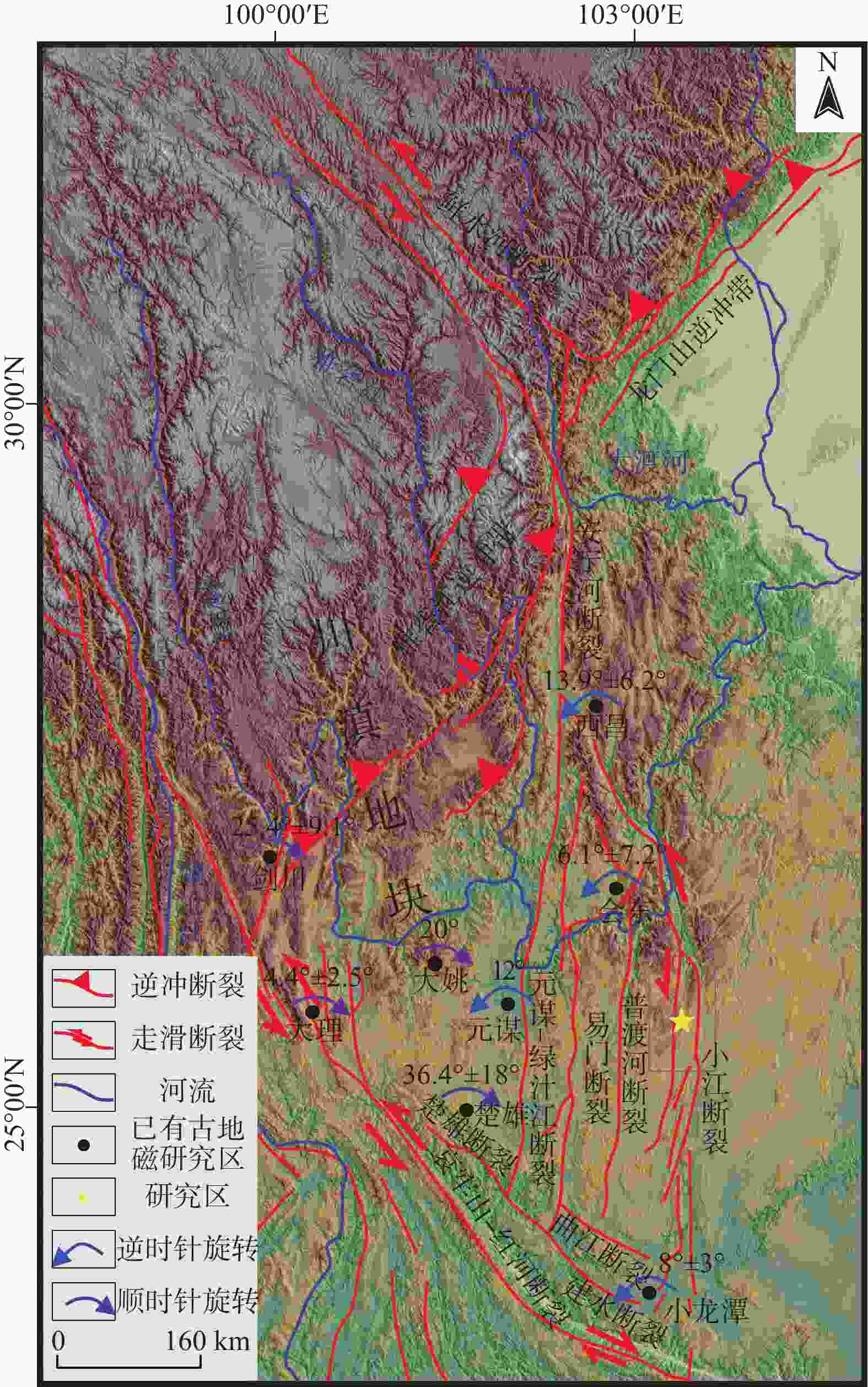
图 1 研究区构造简图(Huang et al.,1992;Yoshioka et al.,2003;Tamai et al.,2004;Zhu et al.,2008;Li et al.,2013,2015;Tong et al.,2015;王恒和杨振宇,2019;余华玉等,2023)
Figure 1. Structural diagram of the study area (Huang et al., 1992; Yoshioka et al., 2003; Tamai et al., 2004; Zhu et al., 2008; Gao, 2013; Li et al., 2013; Tong et al., 2015; Wang and Yang, 2019; Yu et al., 2023)
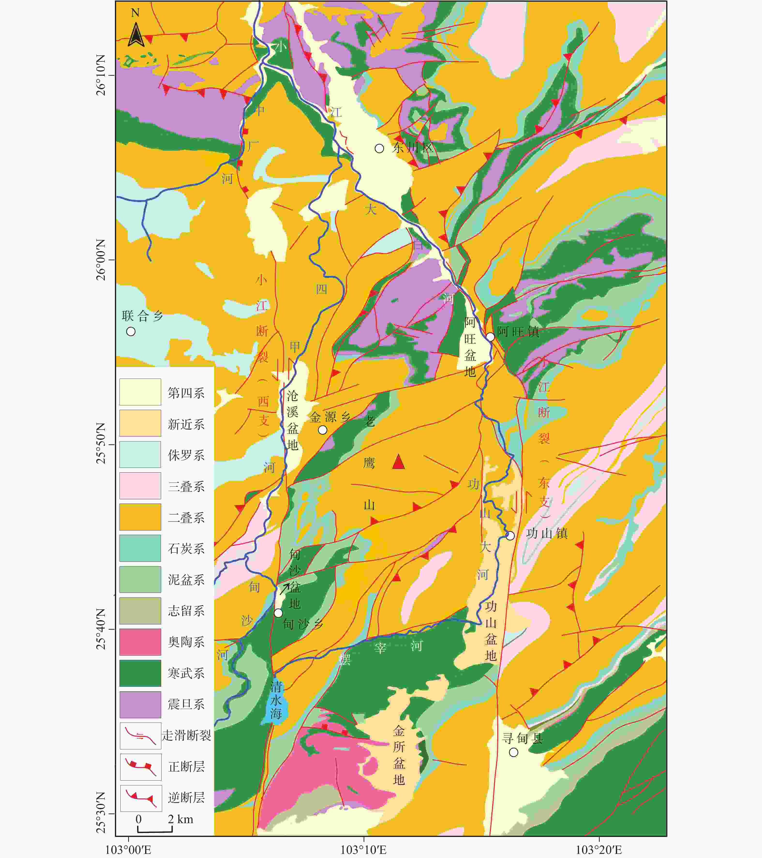
图 2 老鹰山地区地质图(据覃胜荣,1978修改)
Figure 2. Geological map of Laoyingshan (modified from Qin, 1978)
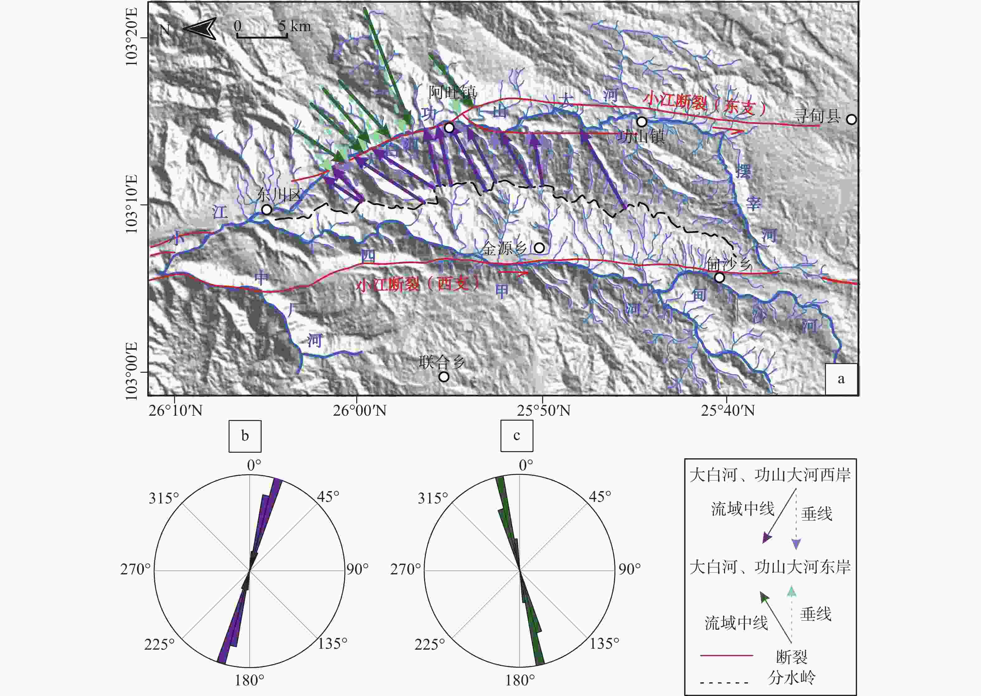
图 6 大白河、功山大河两侧流域方位角及生成的玫瑰图
a—大白河、功山大河两侧生成的流域方位角;b—大白河、功山大河西侧流域方位角生成的玫瑰图;c—大白河、功山大河东侧流域方位角生成的玫瑰图
Figure 6. The azimuth of the basins on both sides of Dabai River and Gongshan River and the generated rose diagram
(a) Basin azimuth generated on both sides of Dabai River and Gongshan River;(b) Rose diagram of the basin azimuth analysis on the western side of Dabai River and Gongshan River;(c) Rose diagram of the basin azimuth analysis on the east side of Dabai River and Gongshan River
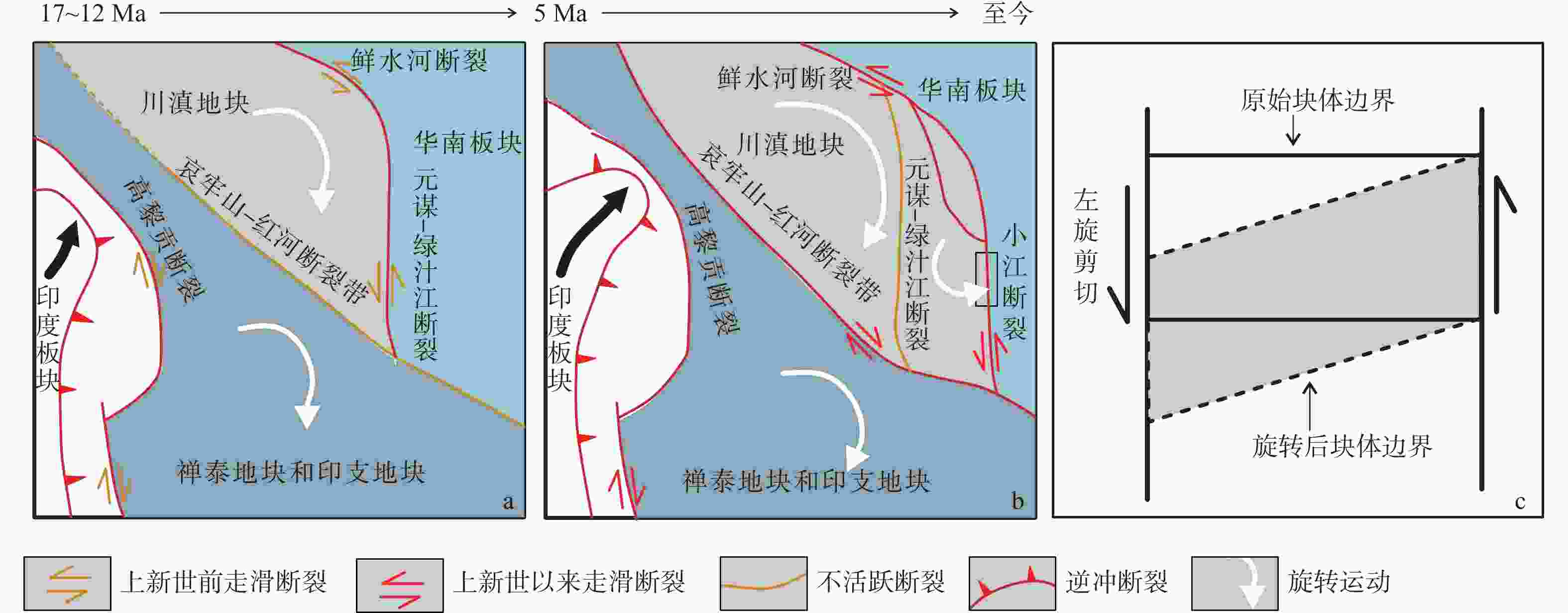
图 8 川滇地块构造活动演变(Tong et al.,2015;吴中海等,2015)
a—b—17 Ma以来川滇地块的构造演化过程;c—老鹰山地区受力旋转过程
Figure 8. Evolution of tectonic activity in the Sichuan-Yunnan block (modified according to Tong et al., 2015; Wu et al., 2015)
(a)—(b) Tectonic evolution of the Sichuan-Yunnan block since 17 Ma;(c) Rotational stress process in Laoyingshan region
表 1 大白河、功山大河西侧流域方位角
Table 1. Basin azimuth on the western side of Dabai River and Gongshan River
河流 流域中线方位角/
(°)垂线方位角/
(°)旋转量/
(°)平均旋转量/
(°)1 47.4035 35.5030 11.9005 14.9956 2 56.8472 39.2746 17.5726 3 61.7182 43.5887 18.1295 4 36.7287 24.0545 12.6742 5 34.9060 23.0075 11.8985 6 18.4842 8.4548 10.0294 7 30.4826 13.6866 16.7960 8 31.1446 14.6053 16.5393 9 29.4522 21.8166 7.6356 10 30.9373 14.6053 16.3320 11 26.3950 0.9501 25.4449 表 2 大白河、功山大河东侧流域方位角
Table 2. Basin azimuth on the eastern side of Dabai River and Gongshan River
河流 流域中线方位角/
(°)垂线方位角/
(°)旋转量/
(°)平均旋转量/
(°)1 222.3619 206.4810 15.8809 12.2181 2 213.5884 208.1903 5.3981 3 219.7653 208.5652 11.2002 4 229.0780 211.4550 17.6230 5 230.8436 220.5600 10.2836 6 216.6224 203.6995 12.9229 -
[1] BERNARD T, SINCLAIR H D, GAILLETON B, et al., 2019. Lithological control on the post-orogenic topography and erosion history of the Pyrenees[J]. Earth and Planetary Science Letters, 518: 53-66. doi: 10.1016/j.jpgl.2019.04.034 [2] CAO P J, CHENG S Y, LIN H X, et al., 2021. DEM in quantitative analysis of structural geomorphology: application and prospect[J]. Journal of Geomechanics, 27(6): 949-962. (in Chinese with English abstract [3] CASTELLTORT S, GOREN L, WILLETT S D, et al., 2012. River drainage patterns in the New Zealand Alps primarily controlled by plate tectonic strain[J]. Nature Geoscience, 5(10): 744-748. doi: 10.1038/ngeo1582 [4] CHEN S F, WILSON C J L, 1996. Emplacement of the Longmen Shan Thrust-Nappe Belt along the eastern margin of the Tibetan Plateau[J]. Journal of Structural Geology, 18(4): 413-430. [5] CRUSLOCK E M, NAYLOR L A, FOOTE Y L, et al., 2010. Geomorphologic equifinality: a comparison between shore platforms in Höga Kusten and Fårö, Sweden and the Vale of Glamorgan, South Wales, UK[J]. Geomorphology, 114(1-2): 78-88. doi: 10.1016/j.geomorph.2009.02.019 [6] DAI Y, WANG X Y, WANG S L, et al., 2016. The neotectonic activity of Wanchuan catchment reflected by geomorphic indices[J]. Acta Geographica Sinica, 71(3): 412-421. (in Chinese with English abstract [7] DUAN J X, DONG Y P, WU K, et al., 2021. Characteristics of river networks in the central Yunnan Province and their responses to tectonic activities[J]. Geotectonica et Metallogenia, 45(2): 296-307. (in Chinese with English abstract [8] FENG J L, CUI Z J, ZHANG W, et al., 2004. Genesis of the layered landform surfaces in Dongchuan, Yunnan Province[J]. Mountain Research, 22(2): 165-174. (in Chinese with English abstract [9] FOX M, GOREN L, MAY D A, et al., 2014. Inversion of fluvial channels for paleorock uplift rates in Taiwan[J]. Journal of Geophysical Research: Earth Surface, 119(9): 1853-1875. doi: 10.1002/2014JF003196 [10] FOX M, HERMAN F, KISSLING E, et al., 2015. Rapid exhumation in the Western Alps driven by slab detachment and glacial erosion[J]. Geology, 43(5): 379-382. doi: 10.1130/G36411.1 [11] GAO L, 2013. Cretaceous and Paleogene paleomagnetic results from the southeastern part of eastern Himalaya syntaxis and its implication for tectonic evolution[D]. Nanjing: Nanjing University. (in Chinese with English abstract [12] GOREN L, FOX M, WILLETT S D, 2014. Tectonics from fluvial topography using formal linear inversion: theory and applications to the Inyo Mountains, California[J]. Journal of Geophysical Research: Earth Surface, 119(8): 1651-1681. doi: 10.1002/2014JF003079 [13] GOREN L, CASTELLTORT S, KLINGER Y, 2015. Modes and rates of horizontal deformation from rotated river basins: application to the dead sea fault system in Lebanon[J]. Geology, 43(9): 843-846. doi: 10.1130/G36841.1 [14] GUAN X, PANG L C, JIANG Y T, et al., 2021. Spatial characteristics of quantitative geomorphic indices in the Taihang Mountains, north China: Implications for tectonic geomorphology[J]. Journal of Geomechanics, 27(2): 280-293. (in Chinese with English abstract [15] GUERIT L, DOMINGUEZ S, MALAVIEILLE J, et al., 2016. Deformation of an experimental drainage network in oblique collision[J]. Tectonophysics, 693: 210-222. doi: 10.1016/j.tecto.2016.04.016 [16] HUANG K N, OPDYKE N D, PENG X J, et al., 1992. Paleomagnetic results from the Upper Permian of the eastern Qiangtang Terrane of Tibet and their tectonic implications[J]. Earth and Planetary Science Letters, 111(1): 1-10. doi: 10.1016/0012-821X(92)90164-Q [17] JACQUES F M B, SU T, SPICER R A, et al., 2014. Late Miocene southwestern Chinese floristic diversity shaped by the southeastern uplift of the tibetan plateau[J]. Palaeogeography, Palaeoclimatology, Palaeoecology, 411: 208-215. doi: 10.1016/j.palaeo.2014.05.041 [18] KIRBY E, WHIPPLE K, 2001. Quantifying differential rock-uplift rates via stream profile analysis[J]. Geology, 29(5): 415-418. doi: 10.1130/0091-7613(2001)029<0415:QDRURV>2.0.CO;2 [19] KIRBY E, WHIPPLE K X, TANG W Q, et al., 2003. Distribution of active rock uplift along the eastern margin of the Tibetan Plateau: inferences from bedrock channel longitudinal profiles[J]. Journal of Geophysical Research: Solid Earth, 108(B4): 2217. [20] KIRBY E, WHIPPLE K X, 2012. Expression of active tectonics in erosional landscapes[J]. Journal of Structural Geology, 44: 54-75. doi: 10.1016/j.jsg.2012.07.009 [21] LI S H, DENG C L, YAO H T, et al., 2013. Magnetostratigraphy of the Dali Basin in Yunnan and implications for late Neogene rotation of the southeast margin of the Tibetan Plateau[J]. Journal of Geophysical Research: Solid Earth, 118(3): 791-807. doi: 10.1002/jgrb.50129 [22] LI S H, DENG C L, DONG W, et al., 2015. Magnetostratigraphy of the Xiaolongtan Formation bearing Lufengpithecus keiyuanensis in Yunnan, southwestern China: constraint on the initiation time of the southern segment of the Xianshuihe-Xiaojiang fault[J]. Tectonophysics, 655: 213-226. doi: 10.1016/j.tecto.2015.06.002 [23] LI X, 2015. Study on boundary fault rupture Characterics of the Sichuan-Yunnan block at different development stages in Yunnan Province[D]. Beijing: Institute of Geology, China Earthquake Administrator. (in Chinese with English abstract [24] LIN X D, 2009. The analysis on focal mechanism solution and tectonic stress field of middle part of Xiaojiang fault and its adjacent areas[D]. China Lanzhou: Earthquake Administration Lanzhou Institute of Seismology. (in Chinese with English abstract [25] LIU J, DING L, ZENG L S, et al., 2006. Large-scale terrain analysis of selected regions of the Tibetan Plateau: discussion on the origin of plateau planation surface[J]. Earth Science Frontiers, 13(5): 285-299. (in Chinese with English abstract [26] LIU Y, HOU Z Q, TIAN S H, et al., 2015. Zircon U-Pb ages of the Mianning-Dechang syenites, Sichuan Province, southwestern China: Constraints on the giant REE mineralization belt and its regional geological setting(Article)[J]. Ore Geology Reviews, 64: 554-568 doi: 10.1016/j.oregeorev.2014.03.017 [27] QIN S R, 1978. Qujing G-48-20 1/200000 regional geological survey report[R]. Beijing:National Geological Information Center. DOI:10.35080/n01.c.65702 (in Chinese with English abstract [28] RAMSEY L A, WALKER R T, JACKSON J, 2007. Geomorphic constraints on the active tectonics of southern Taiwan[J]. Geophysical Journal International, 170(3): 1357-1372. doi: 10.1111/j.1365-246X.2007.03444.x [29] ROGER F, CALASSOU S, LANCELOT J, et al., 1995. Miocene emplacement and deformation of the Konga Shan granite (Xianshui He fault zone, west Sichuan, China): geodynamic implications[J]. Earth and Planetary Science Letters, 130(1-4): 201-216. doi: 10.1016/0012-821X(94)00252-T [30] ROGER F, MALAVIEILLE J, LELOUP P H, et al., 2004. Timing of granite emplacement and cooling in the Songpan–Garzê Fold Belt (eastern Tibetan Plateau) with tectonic implications[J]. Journal of Asian Earth Sciences, 22(5): 465-481. doi: 10.1016/S1367-9120(03)00089-0 [31] SCHOENBOHM L M, BURCHFIEL B C, LIANGZHONG C, et al., 2006. Miocene to present activity along the Red River fault, China, in the context of continental extrusion, upper-crustal rotation, and lower-crustal flow[J]. Geological Society of America Bulletin, 118(5-6): 672-688. doi: 10.1130/B25816.1 [32] SHEN J, WANG Y P, SONG F M, 2003. Characteristics of the active Xiaojiang fault zone in Yunnan, China: a slip boundary for the southeastward escaping Sichuan–Yunnan block of the Tibetan Plateau[J]. Journal of Asian Earth Sciences, 21(10): 1085-1096. doi: 10.1016/S1367-9120(02)00185-2 [33] SNYDER N P, WHIPPLE K X, TUCKER G E, et al., 2000. Landscape response to tectonic forcing: Digital elevation model analysis of stream profiles in the Mendocino triple junction region, northern California[J]. Geological Society of America Bulletin, 112(8): 1250-1263. doi: 10.1130/0016-7606(2000)112<1250:LRTTFD>2.0.CO;2 [34] SONG F M, WANG Y P, YU W X, et al. , 1998. Research on China's active fault "Xiaojiang Active Fault Zone"[M]. Beijing: Seismological Press. (in Chinese) [35] TAMAI M, LIU Y Y, LU L Z, et al., 2004. Palaeomagnetic evidence for southward displacement of the Chuan Dian fragment of the Yangtze block[J]. Geophysical Journal International, 158(1): 297-309. doi: 10.1111/j.1365-246X.2004.02108.x [36] TAO Y L, ZHANG H P, GE Y K, et al., 2020. Cenozoic exhumation and fault activities across the eastern Tibet: constraints from low-temperature thermochronological data[J]. Chinese Journal of Geophysics, 63(11): 4154-4167. (in Chinese with English abstract [37] TAPPONNIER P, XU Z Q, ROGER F, et al., 2001. Oblique stepwise rise and growth of the Tibet Plateau[J]. Science, 294(5547): 1671-1677. doi: 10.1126/science.105978 [38] TONG Y B, YANG Z Y, WANG H, et al., 2015. The Cenozoic rotational extrusion of the Chuan Dian Fragment: New paleomagnetic results from Paleogene red-beds on the southeastern edge of the Tibetan Plateau[J]. Tectonophysics, 658: 46-60. doi: 10.1016/j.tecto.2015.07.007 [39] TRAUERSTEIN M, NORTON K P, PREUSSER F, et al., 2013. Climatic imprint on landscape morphology in the western escarpment of the Andes[J]. Geomorphology, 194: 76-83. doi: 10.1016/j.geomorph.2013.04.015 [40] WANG E, BURCHFIEL B C, ROYDEN L H, et al. , 1998. Late Cenozoic Xianshuihe-Xiaojiang, Red River, and Dali fault systems of southwestern Sichuan and Central Yunnan, China[M]. Boulder: The Geological Society of America: 1-108. [41] WANG H, YANG Z Y, 2019. Differential rotation in the western Sichuan-Yunnan block and its geological implications: New palaeomagnetic evidence from the Cretaceous red beds in the southeastern margin of the Tibetan Plateau[J]. Chinese Journal of Geophysics, 62(5): 1789-1808. (in Chinese with English abstract [42] WANG N R, HAN Z Y, LI X S, et al., 2015. Tectonic uplift of Mt. Lushan indicated by the steepness indices of the river longitudinal profiles[J]. Acta Geographica Sinica, 70(9): 1516-1525. (in Chinese with English abstract [43] WHIPPLE K X, TUCKER G E, 1999. Dynamics of the stream-power river incision model: Implications for height limits of mountain ranges, landscape response timescales, and research needs[J]. Journal of Geophysical Research: Solid Earth, 104(B8): 17661-17674. doi: 10.1029/1999JB900120 [44] WHIPPLE K X, 2001. Fluvial landscape response time: How plausible is steady-state denudation?[J]. American Journal of Science, 301(4-5): 313-325. doi: 10.2475/ajs.301.4-5.313 [45] WILLETT S D, 1999. Orogeny and orography: the effects of erosion on the structure of mountain belts[J]. Journal of Geophysical Research: Solid Earth, 104(B12): 28957-28981. doi: 10.1029/1999JB900248 [46] WOBUS C W, HODGES K V, WHIPPLE K X, 2003. Has focused denudation sustained active thrusting at the Himalayan topographic front?[J]. Geology, 31(10): 861-864. doi: 10.1130/G19730.1 [47] WOBUS C W, WHIPPLE K X, HODGES K V, 2006. Neotectonics of the central Nepalese Himalaya: Constraints from geomorphology, detrital 40Ar/39Ar thermochronology, and thermal modeling[J]. Tectonics, 25(4): TC4011. [48] WU Z H, LONG C X, FAN T Y, et al., 2015. The arc rotational-shear active tectonic system on the southeastern margin of Tibetan Plateau and its dynamic characteristics and mechanism[J]. Geological Bulletin of China, 34(1): 1-31. (in Chinese with English abstract [49] YıLDıRıM C, TÜYSÜZ O, 2017. Estimation of the long-term slip, surface uplift and block rotation along the northern strand of the North Anatolian Fault Zone: Inferences from geomorphology of the Almacık block[J]. Geomorphology, 297: 55-68. doi: 10.1016/j.geomorph.2017.08.038 [50] YOSHIOKA S, LIU Y Y, SATO K, et al., 2003. Paleomagnetic evidence for post-cretaceous internal deformation of the Chuan Dian fragment in the Yangtze block: a consequence of indentation of India into Asia[J]. Tectonophysics, 376(1-2): 61-74. doi: 10.1016/j.tecto.2003.08.010 [51] YU H Y, DONG Y P, YU L, et al. , 2023. Study on relative tectonic activity of the Puduhe fault in central Yunnan[J/OL]. Earth Science: 1-15[2023-05-15]. https://kns.cnki.net/kcms2/article/abstract?v=wQLHse-Rxfdai4mkyxezsT1y3SFE_-VUa2wV5L-87ugnPcjUGW38tgFmkZ7lKJUQDbszKpyAzH27xRlTPEZUL4zSjloi4chpSQeGWtbc9jVZ_VBfdI7JNohQJcr0D2Mg0pMWxC-2hvQ=&uniplatform=NZKPT&language=CHS. (in Chinese with English abstract [52] ZHANG D Y, DONG Y P, JIAO Q Q, et al., 2023. Three periods of Cenozoic tectonic uplift in the southeastern margin of the Tibetan Plateau - evidence from fluvial longitudinal profile analysis[J]. Geotectonica et Metallogenia, 47(2): 308-326. (in Chinese with English abstract [53] ZHANG H P, LIU S F, SUN Y P, et al., 2006. The acquisition of local topographic relief and its application: an SRTM-DEM analysis[J]. Remote sensing for Land & Resources, 18(1): 31-35. (in Chinese with English abstract [54] ZHANG Y Q, CHEN W, YANG N, 2004. 40Ar/39Ar dating of shear deformation of the Xianshuihe fault zone in west Sichuan and its tectonic significance[J]. Science in China Series D: Earth Sciences, 47(9): 794-803. doi: 10.1007/BF03653272 [55] ZHANG Y Z, REPLUMAZ A, LELOUP P H, et al., 2017. Cooling history of the Gongga batholith: implications for the Xianshuihe fault and Miocene kinematics of se Tibet[J]. Earth and Planetary Science Letters, 465: 1-15. doi: 10.1016/j.jpgl.2017.02.025 [56] ZHENG L L, KONG F Q, HUANG Z H, et al., 2019. The pleistocene activity of Cangxi-Qingshuihai Fault of the west branch in the middle segment of Xiaojiang Fault[J]. Science Technology and Engineering, 19(14): 39-45. (in Chinese with English abstract [57] ZHU R X, POTTS R, PAN Y X, et al., 2008. Paleomagnetism of the Yuanmou Basin near the southeastern margin of the Tibetan Plateau and its constraints on late Neogene sedimentation and tectonic rotation[J]. Earth and Planetary Science Letters, 272(1-2): 97-104. doi: 10.1016/j.jpgl.2008.04.016 [58] 曹鹏举,程三友,林海星,等,2021. DEM在构造地貌定量分析中的应用与展望[J]. 地质力学学报,27(6):949-962. doi: 10.12090/j.issn.1006-6616.2021.27.06.077 [59] 戴岩,王先彦,王胜利,等,2016. 地貌形态指数反映的青藏高原东北部宛川河流域新构造活动[J]. 地理学报,71(3):412-421. doi: 10.11821/dlxb201603005 [60] 段佳鑫,董有浦,吴可,等,2021. 滇中河网特征及其对断层活动的响应[J]. 大地构造与成矿学,45(2):296-307. [61] 冯金良,崔之久,张威,等,2004. 云南东川地区层状地貌面的成因[J]. 山地学报,22(2):165-174. doi: 10.3969/j.issn.1008-2786.2004.02.006 [62] 高亮,2013. 青藏高原东构造结东南缘地区白垩纪与古近纪古地磁与构造演化[D]. 南京:南京大学. [63] 关雪,逄立臣,姜雨彤,等,2021. 太行山地貌计量指标空间特征及其构造地貌意义[J]. 地质力学学报,27(2):280-293. doi: 10.12090/j.issn.1006-6616.2021.27.02.026 [64] 李西,2015. 川滇地块云南地区不同发育阶段边界断裂破裂特征研究[D]. 北京:中国地震局地质研究所. [65] 林向东,2009. 小江断裂中段及其邻近地区震源机制解与构造应力场分析[D]. 兰州:中国地震局兰州地震研究所. [66] 刘静,丁林,曾令森,等,2006. 青藏高原典型地区的地貌量化分析:兼对高原“夷平面”的讨论[J]. 地学前缘,13(5):285-299. doi: 10.3321/j.issn:1005-2321.2006.05.002 [67] 覃胜荣, 1978. 曲靖幅G-48-20 1/20万区域地质调查报告[R]. 北京:全国地质资料馆. DOI: 10.35080/n01.c.65702 [68] 宋方敏,汪一鹏,俞维贤,等,1998. 小江活动断裂带[M]. 北京:地震出版社. [69] 陶亚玲,张会平,葛玉魁,等,2020. 青藏高原东缘新生代隆升剥露与断裂活动的低温热年代学约束[J]. 地球物理学报,63(11):4154-4167. doi: 10.6038/cjg2020O0300 [70] 王恒,杨振宇,2019. 川滇地块西部差异性旋转的构造意义:青藏高原东南缘白垩纪红层古地磁学新证据[J]. 地球物理学报,62(5):1789-1808. doi: 10.6038/cjg2019L0786 [71] 王乃瑞,韩志勇,李徐生,等,2015. 河流纵剖面陡峭指数对庐山构造抬升的指示[J]. 地理学报,70(9):1516-1525. doi: 10.11821/dlxb201509013 [72] 吴中海,龙长兴,范桃园,等,2015. 青藏高原东南缘弧形旋扭活动构造体系及其动力学特征与机制[J]. 地质通报,34(1):1-31. doi: 10.3969/j.issn.1671-2552.2015.01.002 [73] 余华玉,董有浦,于良,等,2023. 滇中普渡河断裂相对构造活动性特征[J/OL]. 地球科学:1-15[2023-05-15]. https://kns.cnki.net/kcms2/article/abstract?v=wQLHse-Rxfdai4mkyxezsT1y3SFE_-VUa2wV5L-87ugnPcjUGW38tgFmkZ7lKJUQDbszKpyAzH27xRlTPEZUL4zSjloi4chpSQeGWtbc9jVZ_VBfdI7JNohQJcr0D2Mg0pMWxC-2hvQ=&uniplatform=NZKPT&language=CHS. [74] 张东越,董有浦,焦骞骞,等,2023. 青藏高原东南缘新生代的三期构造隆升—来自河流纵剖面分析的证据[J]. 大地构造与成矿学,47(2):308-326. [75] 张会平,刘少峰,孙亚平,等,2006. 基于SRTM-DEM区域地形起伏的获取及应用[J]. 国土资源遥感,18(1):31-35. [76] 郑立龙,孔凡全,黄赞慧,等,2019. 小江断裂带中段西支沧溪-清水海断层更新世活动性[J]. 科学技术与工程,19(14):39-45. doi: 10.3969/j.issn.1671-1815.2019.14.006 -


 下载:
下载:
