

Discovery of the surface rupture zone along the southern branch of the Longshoushan Fault Zone, NW China and its significance to the deep structures of the 1954 Shandan MS 7¼ earthquake
-
摘要: 基于详细的遥感解译和野外调查,发现龙首山南缘断裂发育有较新的地震地表破裂遗迹,包括断层坎、地震鼓包、河道的系统位错等断层地貌标志,破裂带总长度超过20 km,沿断裂走向其垂向位移介于0.35~4 m,水平位移介于0.3~1.9 m,龙首山南缘断裂主体表现为逆冲性质,仅在西端表现为局部左旋走滑的性质。通过剖面和探槽揭示,龙首山南麓地区全新世以来发生多次断层活动,最新的一次在约3.96 ka以来。经过与区域内的强震记录比对,认为此次新发现的地震地表破裂带可能是1954年山丹MS 7¼地震所致。1954年山丹MS 7¼地震在浅表沿两条断裂同时发生了地表破裂,表现为正花状构造的变形样式。这种同震位移分配现象以往多发现于走滑型地震中,此次在逆冲型地震中发现。龙首山南缘断裂地表破裂带的发现为揭示1954年山丹地震的震源过程和破裂样式提供了新的证据和思路。
-
关键词:
- 青藏高原东北缘 /
- 1954山丹MS 7¼地震 /
- 龙首山断裂带 /
- 同震地表破裂 /
- 花状构造
Abstract: A detailed field-based remote sensing interpretation in this study revealed abundant recent seismic surface ruptures on the southern margin of the Longshoushan Fault, including fault scarps, mole tracks and displacements of river channels. The total length of the surface rupture zone is over 20 km. The most recent vertical and horizontal displacements of the late Quaternary geomorphic markers fall into the range of 0.35~4 m and 0.3~1.9 m, respectively. The southern Longshoushan Fault is a high-angle thrust fault, and it only exhibits left-lateral strike-slip on the west end. Revealed by profile and trench along the surface rupture, the southern branch of the Longshoushan Fault Zone has gone through several earthquake events since the Holocene, and the latest one happened around 3.96 ka. By comparing with the strongest earthquake recorded in this region, it is suggested that the 1954 MS 7¼ Shandan earthquake may have caused the newly discovered surface ruptures, which developed along both the southern and northern branches of the Longshoushan fault zone, presenting a positive flower structure at the shallow surface. This coseismic displacement distribution mostly is found in strike-slip earthquakes in previous studies, but it is found in a thrust earthquake this time. The discovery of coseismic surface rupture on the southern branch of the Longshoushan Fault Zone will throw light on the focal mechanism and rupture pattern of the 1954 Shandan MS 7¼ earthquake. -

图 1 龙首山地区及其邻区DEM解译图
F1—东昆仑断裂;F2—柴北缘断裂;F3—阿尔金断裂;F4—北祁连断裂;F5—海原断裂;F6—龙首山南缘断裂;F7—龙首山北缘断裂;F8—阿右旗断裂;F9—合黎山断裂
a—研究区大地构造位置图;b—河西走廊地区历史地震记录及青藏高原东北缘主要断裂分布(据Xu et al., 2010; Wang et al., 2020修改)Figure 1. DEM interpretation of the Longshoushan and its adjacent areas
(a) Geotectonic location of the study area; (b) Historical seismic records in the Hexi Corridor and distribution of main faults in the northeastern margin of the Tibet Plateau (Modified from Xu et al., 2010; Wang et al., 2020)
F1-Eastern Kunlun Fault; F2-Northern Qaidam Fault; F3-Altyn Tagh Fault; F4-Northern Qilian Fault; F5-Haiyuan Fault; F6-Southern Longshoushan Fault; F7-Northern Longshoushan Fault; F8-Ayouqi Fault; F9-Helishan Fault
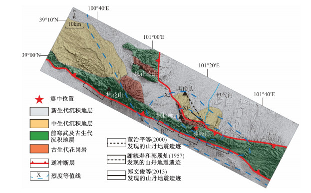
图 2 研究区地质简图(据李佳昱等,2020修改; 北缘破裂带位置和烈度等值线来源于謝毓寿和郭履灿(1957)、董治平等(2000)、郑文俊等(2013))
Figure 2. Geological map of study area (Modified from Li et al., 2020; Location of the northern Longshoushan surface rupture and seismic intensity sourced from Xie and Guo, 1957; Dong et al., 2000; Zheng et al., 2013)

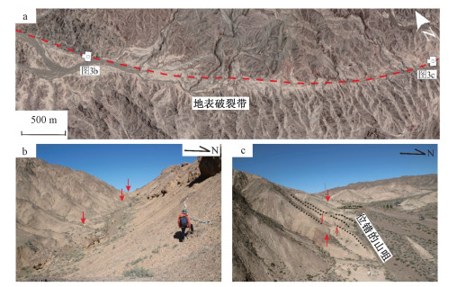
图 3 桃花山附近断层地貌特征
a—桃花拉山破裂带卫星图像;b—断层谷地;c—位错的山咀
Figure 3. Faulted landform surrounding the Taohuashan site
(a) Satellite image showing the topographic features in the Taohuashan fault zone; (b) Fault valley along the southern branch fault of the Longshoushan fault zone; (c) Dislocated ridge

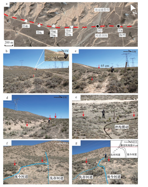
图 4 独峰顶西段破裂带照片解译
a—独峰顶西段地表破裂带卫星图像;b—d—具有不同位移大小的断层坎;e—g—冲沟改道
Figure 4. Surface rupture characteristics at the western section of Dufengding
(a) Satellite image showing the topographic features at the western section of Dufengding; (b-d) Fault scarps with varied vertical displacements; (e-g) River migration due to the relative movement of strike-slip fault

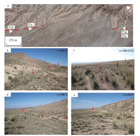
图 5 独峰顶中段地表破裂特征
a—独峰顶中段卫星图像;b—断层坎;c—地震鼓包;d、e—断层坎及坡中谷中生长的茂盛的芦苇,指示下部有地下水活动
Figure 5. Surface raptures at the central section of Dufengding
(a) Satellite image showing the surface raptures at the central setion of Dufengding; (b) Fault scarp; (c) Mole track; (d-e) Fault scarps facing south with reeds around, indicating underground activity

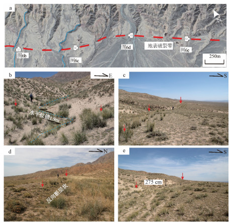
图 6 独峰顶东段地表破裂特征
a—独峰顶东段卫星图像;b—冲沟位错现象,断层左旋走滑位错约1.9 m;c—断层坎;d—反向断层坎;e—断层坎(垂直位错约2.65~2.75 m)
Figure 6. Surface ruptures at the eastern section of Dufengding
(a) Satellite image showing the locations of outcrops at the eastern section of Dufengding; (b) Left-lateral strike-slip displacement of the river channel with a offset amount of~1.9 m; (c) Fault scarp; (d) Fault scarp facing the ridge; (e) Fault scarp with a vertical displacement of 2.65~2.75 m

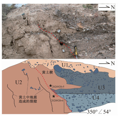
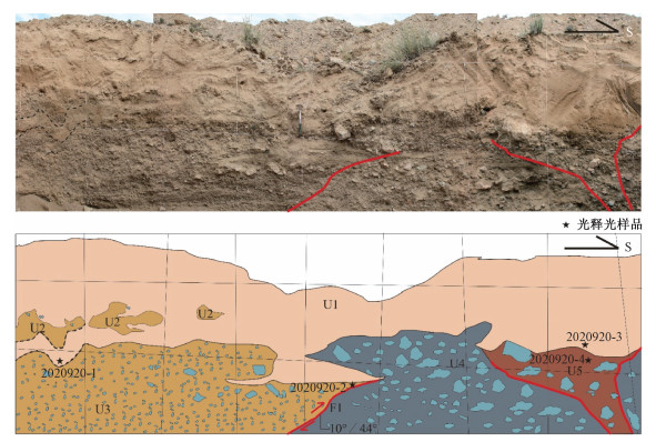
图 7 河道天然剖面照片及素描图(位置见图 4a)
U1—含中砾松散黏土;U2—细粒黄土沉积;U3—深灰色河流相中—粗粒砾岩;U4—浅灰色河流相中—粗粒砾岩
Figure 7. Photo and sketch of the natural outcrop (see Fig. 4a for the location)
U1-Loose clay with medium pebbly; U2-Fine-grained loess; U3-Dark grey fluvial medium-coarse conglomerate; U4-Light grey fluvial medium-coarse conglomerate


图 9 龙首山南缘断裂和北缘断裂深部模式图
Figure 9. Simplified model showing the deep structures of the northern and southern branch faults of the Longshoushan Fault Zone
表 1 光释光样品年龄结果
Table 1. Results of the OSL samples
样品编号 U/×10-6 Th/×10-6 K/% 含水率/% 剂量率/(Ga/ka) 等效剂量/Gy 年龄/ka 2020920-1 3.74±0.03 14.05±0.20 3.22±0.08 10±5 5.89±0.32 23.98±0.82 4.07±0.26 2020920-2 5.07±0.06 17.66±0.19 2.25±0.04 10±5 4.65±0.14 89.45±10.91 19.25±2.42 2020920-3 3.72±0.03 15.38±0.14 2.00±0.05 10±5 4.85±0.29 46.10±1.20 9.50±0.62 2020920-4 3.24±0.04 15.37±0.18 2.87±0.07 10±5 5.53±0.30 44.53±1.97 8.05±0.56 2020920-5 3.25±0.03 12.63±0.13 1.99±0.02 10±5 4.47±0.25 17.73±0.55 3.96±0.26 2020920-6 3.43±0.10 12.54±0.45 1.97±0.01 10±5 4.47±0.26 30.33±0.53 6.79±0.41  下载: 导出CSV
-
BU RCHFIEL B C, ZHANG P Z, WANG Y P, et al., 1991. Geology of the haiyuan fault zone, ningxia-hui autonomous region, China, and its relation to the evolution of the Northeastern margin of the Tibetan Plateau[J]. Tectonics, 10(6): 1091-1110. doi: 10.1029/90TC02685 CHEN P, SHI W, LIU Y, et al., 2022. Slip rate deficit partitioned by fault-fold system on the active haiyuan fault zone, northeastern Tibetan Plateau[J]. Journal of Structural Geology, 155: 104516, doi: 10.1016/j.jsg.2022.104516. DENG Q D, YU G H, YE W H, 1992. Relationship between earthquake magnitude and parameters of surface ruptures associated with historical earthquake[M]//Institute of Geology, SSB. Research on active fault (2). Beijing: Earthquake Publishing House: 247-264. (in Chinese) DONG Z P, HE W G, DAI H G, 2000. A brief introduction of rupture zone of the Shandan earthquake, 1954[J]. Northwestern Seismological Journal, 22(1): 46. (in Chinese) DONG Z P, HE W G, DAI H G, 2002. Preliminary research on paleoearthquakes of the Baodaihe fault[J]. Northwestern Seismological Journal, 24(3): 225-229. (in Chinese with English abstract) DONG Z P, CHEN Y H, WANG P, et al., 2007. Investigation on the Shandan MS 7.3 earthquake damages in 1954[J]. Earthquake Research in China, 23(2): 157-165. (in Chinese with English abstract) FANG X M, ZHAO Z J, LI J J, et al., 2005. Magnetostratigraphy of the late Cenozoic Laojunmiao anticline in the northern Qilian Mountains and its implications for the northern Tibetan Plateau uplift[J]. Science in China Series D Earth Sciences, 48(7): 1040-1051. doi: 10.1360/03yd0188 Geology and Mineral Resource Bureal of Gansu Province, 1989. Regional geology of Gansu province[M]. Beijing: Geological Publishing House. (in Chinese) GUO P, HAN Z J, GAO F, et al., 2020. A new tectonic model for the 1927 M 8.0 Gulang earthquake on the NE Tibetan Plateau[J]. Tectonics, 39(9): e2020TC006064. HAMLING I J, HREINSDÓTTIR S, CLARK K, et al., 2017. Complex multifault rupture during the 2016 MW 7.8 Kaikōura earthquake, New Zealand[J]. Science, 356(6334): eaam7194. doi: 10.1126/science.aam7194 HAN S, WU Z H, GAO Y, et al., 2022. Surface rupture investigation of the 2022 Menyuan MS 6.9 earthquake, Qinghai, China: implications for the fault behavior of the Lenglongling fault and regional intense earthquake risk[J]. Journal of Geomechanics, 28(2): 155-168. (in Chinese with English abstract) HETZEL R, TAO M X, NIEDERMANN S, et al., 2004. Implications of the fault scaling law for the growth of topography: mountain ranges in the broken foreland of North-East Tibet[J]. Terra Nova, 16(3): 157-162. doi: 10.1111/j.1365-3121.2004.00549.x HSIEH Y S, KUO L T, 1957. The Shan-Tan earthquake of February 11, 1954[J]. Acta Geophysica Sinica, 6(2): 159-179. (in Chinese with English abstract) LI J Y, ZHENG W J, WANG W T, et al., 2020. The northward growth of the northeastern tibetan plateau in late cenozoic: implications from apatite (U-Th)/He ages of Longshou Shan[J]. Seismology and Geology, 42(2): 472-491. (in Chinese with English abstract) LIU D L, LI H B, Ge C L, et al., 2021. Northward growth of the west kunlun mountains: insight from the age-elevation relationship of new apatite fission track data[J]. Frontiers in Earth Science, 9: 784812. doi: 10.3389/feart.2021.784812 LIU J, ZHANG Z H, WEN L, et al., 2008. The MS 8.0 Wenchuan earthquake co-seismic rupture and its tectonic implications: an out-of-sequence thrusting event with slip partitioned on multiple faults[J]. Acta Geologica Sinica, 82(12): 1707-1722. (in Chinese with English abstract) LIU J R, REN Z K, ZHANG H P, et al., 2022. Slip rates along the laohushan fault and spatial variation in slip rate along the haiyuan fault zone[J]. Tectonics, 41(2): e2021TC006992. MEYER B, TAPPONNIER P, BOURJOT L, et al., 1998. Crustal thickening in Gansu-Qinghai, lithospheric mantle subduction, and oblique, strike-slip controlled growth of the Tibet Plateau[J]. Geophysical Journal International, 135(1): 1-47. doi: 10.1046/j.1365-246X.1998.00567.x PANG J Z, YU J X, ZHENG D W, et al., 2019. Neogene expansion of the Qilian Shan, North Tibet: implications for the dynamic evolution of the Tibetan Plateau[J]. Tectonics, 38(3): 1018-1032, doi: 10.1029/2018TC005258. SHI Y J, ZHANG Z W, CUN S C, 1995. Discovery of nappe structure in Longshoushan and its geological significance[J]. Chinese Science Bulletin, 40(9): 812-813. (in Chinese) doi: 10.1360/csb1995-40-9-812 TAPPONNIER P, XU Z Q, ROGER F, et al., 2001. Oblique stepwise rise and growth of the Tibet Plateau[J]. Science, 294(5547): 1671-1677. doi: 10.1126/science.105978 TIAN T T, WU Z H, GAI H L, et al., 2022. Dating of multi-period earthquake-triggered rockfalls: a method for revealing paleo-seismic events that occurred along the Yushu fault in the eastern Tibetan Plateau[J]. Landslides, 19(2): 351-371. doi: 10.1007/s10346-021-01730-5 WANG J B. 1987. Satellite Image Interpretation of Seismogenic Fault Characteristics and Seismogeological Background of 1954 Shandan Earthquake [J]. Northwestern Seismological Journal, (3): 119-121. (in Chinese) WANG W T, ZHENG D W, LI C P, et al., 2020. Cenozoic exhumation of the Qilian Shan in the northeastern Tibetan Plateau: evidence from low-temperature thermochronology[J]. Tectonics, 39(4): e2019TC005705. doi: 10.1029/2019TC005705. WELLS D L, COPPERSMITH K J, 1994. New empirical relationships among magnitude, rupture length, rupture width, rupture area, and surface displacement[J]. Bulletin of the Seismological Society of America, 84(4): 974-1002. XU X W, YEATS R S, YU G H, 2010. Five short historical earthquake surface ruptures near the silk road, Gansu province, China[J]. Bulletin of the Seismological Society of America, 100(2): 541-561. doi: 10.1785/0120080282. YIN A, HARRISON T M, 2000. Geologic evolution of the himalayan-Tibetan Orogen[J]. Annual Review of Earth and Planetary Sciences, 28: 211-280. doi: 10.1146/annurev.earth.28.1.211 YU J X, ZHENG W J, ZHANG P Z, et al., 2017. Late Quaternary strike-slip along the Taohuala Shan-Ayouqi fault zone and its tectonic implications in the Hexi Corridor and the southern Gobi Alashan, China[J]. Tectonophysics, 721: 28-44. doi: 10.1016/j.tecto.2017.09.014 YU J X, PANG J Z, WANG Y Z, et al., 2019. Mid-Miocene uplift of the northern Qilian Shan as a result of the northward growth of the northern Tibetan Plateau[J]. Geosphere, 15(2): 423-432. doi: 10.1130/GES01520.1. YUAN D Y, GE W P, CHEN Z W, et al., 2013. The growth of northeastern Tibet and its relevance to large-scale continental geodynamics: a review of recent studies[J]. Tectonics, 32(5): 1358-1370. doi: 10.1002/tect.20081 ZHANG B H, ZHANG J, WANG Y N, et al., 2017. Late mesozoic-cenozoic exhumation of the northern Hexi Corridor: constrained by apatite fission track ages of the Longshoushan[J]. Acta Geologica Sinica-English Edition, 91(5): 1624-1643. doi: 10.1111/1755-6724.13402 ZHANG P Z, ZHENG D W, YIN G M, et al., 2006. Discussion on late cenozoic growth and rise of northeastern margin of the Tibetan Plateau[J]. Quaternary Sciences, 26(1): 5-13. (in Chinese with English abstract) ZHAO Z X, SHI W, YANG Y, et al., 2022. Late Cenozoic magnetostratigraphy and paleoenvironmental change in the northeastern Tibetan Plateau: evidence from a drill core in the Wuwei Basin, NW China[J]. Journal of Asian Earth Sciences, 224: 105023. doi: 10.1016/j.jseaes.2021.105023 ZHENG D W, WANG W T, WAN J L, et al., 2017. Progressive northward growth of the northern Qilian Shan-Hexi Corridor (northeastern Tibet) during the Cenozoic[J]. Lithosphere, 9(3): 408-416, doi: 10.1130/L587.1. ZHENG W J, ZHANG P Z, YUAN D Y, et al., 2009. Discovery of surface rupture zone on the south of Helishan in Gaotai, Gansu Province[J]. Seismology and Geology, 31(2): 247-255. (in Chinese with English abstract) ZHENG W J, ZHANG Z Q, ZHANG P Z, et al., 2013. Seismogenic structure and mechanism of the 1954 M71/4 Shandan Earthquake, Gansu Province, Western China[J]. Chinese Journal of Geophysics, 56(3): 916-928. (in Chinese with English abstract) ZHENG W J, ZHANG H P, ZHANG P Z, et al., 2013a. Late Quaternary slip rates of the thrust faults in western Hexi Corridor (Northern Qilian Shan, China) and their implications for northeastward growth of the Tibetan Plateau[J]. Geosphere, 9(2): 342-354. doi: 10.1130/GES00775.1 ZHENG W J, ZHANG P Z, GE W P, et al., 2013b. Late Quaternary slip rate of the South Heli Shan Fault (Northern Hexi Corridor, NW China) and its implications for northeastward growth of the Tibetan Plateau[J]. Tectonics, 32(2): 271-293. doi: 10.1002/tect.20022 ZHENG W J, ZHANG P Z, YUAN D Y, et al., 2019. Basic characteristics of active tectonics and associated geodynamic processes in continental China[J]. Journal of Geomechanics, 25(5): 699-721. (in Chinese with English abstract) 邓起东, 于贵华, 叶文华, 1992. 地震地表破裂参数与震级关系的研究[M]//国家地震局地质研究所. 活动断裂研究(2). 北京: 地震出版社: 247-264. 董治平, 何文贵, 戴华光, 2000. 1954年山丹地震破裂带初步考证[J]. 西北地震学报, 22(1): 46. https://www.cnki.com.cn/Article/CJFDTOTAL-ZBDZ200001008.htm 董治平, 何文贵, 戴华光, 2002. 包代河断裂古地震初步研究[J]. 西北地震学报, 24(3): 225-229. https://www.cnki.com.cn/Article/CJFDTOTAL-ZBDZ200203005.htm 方小敏, 赵志军, 李吉均, 等, 2004. 祁连山北缘老君庙背斜晚新生代磁性地层与高原北部隆升[J]. 中国科学D辑地球科学, 34(2): 97-106. https://www.cnki.com.cn/Article/CJFDTOTAL-JDXK200402000.htm 甘肃省地质矿产局, 1989. 甘肃省区域地质志[M]. 北京: 地质出版社. 韩帅, 吴中海, 高扬, 等, 2022. 2022年1月8日青海门源MS6.9地震地表破裂考察的初步结果及对冷龙岭断裂活动行为和区域强震危险性的启示[J]. 地质力学学报, 28(2): 155-168. doi: 10.12090/j.issn.1006-6616.2022013 李佳昱, 郑文俊, 王伟涛, 等, 2020. 青藏高原东北部龙首山晚新生代剥露历史: 来自磷灰石(U-Th)/He的证据[J]. 地震地质, 42(2): 472-491. doi: 10.3969/j.issn.0253-4967.2020.02.014 刘静, 张智慧, 文力, 等, 2008. 汶川8级大地震同震破裂的特殊性及构造意义: 多条平行断裂同时活动的反序型逆冲地震事件[J]. 地质学报, 82(12): 1707-1722. doi: 10.3321/j.issn:0001-5717.2008.12.007 石应骏, 张朝文, 寸树苍, 1995. 龙首山推覆构造的发现及其地质意义[J]. 科学通报, 40(9): 812-813. doi: 10.3321/j.issn:0023-074X.1995.09.014 王进宝, 1987. 卫星影象解译1954年山丹地震发震断裂特征及地震地质背景[J]. 西北地震学报, 9(3): 119-121. https://www.cnki.com.cn/Article/CJFDTOTAL-ZBDZ198703020.htm 謝毓寿, 郭履灿, 1957. 1954年2月11日甘肃省山丹县的地震[J]. 地球物理学报, 6(2): 159-179. https://www.cnki.com.cn/Article/CJFDTOTAL-DQWX195702002.htm 张培震, 郑德文, 尹功明, 等, 2006. 有关青藏高原东北缘晚新生代扩展与隆升的讨论[J]. 第四纪研究, 26(1): 5-13. doi: 10.3321/j.issn:1001-7410.2006.01.002 郑文俊, 张培震, 袁道阳, 等, 2009. 甘肃高台合黎山南缘发现地震地表破裂带[J]. 地震地质, 31(2): 247-255. doi: 10.3969/j.issn.0253-4967.2009.02.005 郑文俊, 张竹琪, 张培震, 等, 2013. 1954年山丹71/4级地震的孕震构造和发震机制探讨[J]. 地球物理学报, 56(3): 916-928. https://www.cnki.com.cn/Article/CJFDTOTAL-DQWX201303021.htm 郑文俊, 张培震, 袁道阳, 等, 2019. 中国大陆活动构造基本特征及其对区域动力过程的控制[J]. 地质力学学报, 25(5): 699-721. doi: 10.12090/j.issn.1006-6616.2019.25.05.062 -

 下载:
下载:


计量
- 文章访问数: 1842
- HTML全文浏览量: 528
- PDF下载量: 150
- 被引次数: 0
