

River capture and divide migration of the Zhuozishan area in the northwestern margin of the Ordos Block
-
摘要: 分水岭是水系演化中的动态因素,通过连续或不连续的水系袭夺而发生迁移,从而导致水系重组。传统的对水系演化的研究主要集中单个河流袭夺事件,而新提出的利用分水岭两侧chi(χ)值差异来描述分水岭的动态迁移过程,能够解释大尺度的河流袭夺事件,描述水系的整体演化过程。文章基于12.5 m DEM数据提取了鄂尔多斯西北缘桌子山地区的chi(χ)值揭示其空间分布具有东高西低的特点,反映桌子山的分水岭处于向东迁移过程。综合分析进一步揭示,在桌子山东西两侧的构造升降和降水条件都无明显差异的条件下,岩性抗侵蚀能力差异是控制桌子山分水岭向东迁移的主要因素,当抗侵蚀能力更强的寒武系、奥陶系灰岩位于背斜西翼,而中元古宙长城系(Pt)沉积碎屑岩位于其下部时,背斜西翼的河流具有更强的侵蚀能力,西翼河流可能会穿过背斜核部,从而侧向袭夺东侧的河流。Abstract: Divide is a dynamic feature of a landscape that routinely migrates, either through progressive or discrete river capture, in some cases even leading to the complete reorganization of river networks. Most of the existing geomorphological or drainage evolution studies focus on the single river capture, and few report on the overall movement and the geomorphologic adjustment of divide.Recently, it was proposed in a digital study of fluvial geomorphology that the chi (χ) value difference on both sides of the drainage divide could be used to explain the large-scale river capture and demonstrate the reorganization of drainage when describing the dynamic migration process of divide. In this paper, the chi (χ) values were calculated using the 12.5 m DEM data. The chi (χ) values were higher in the east and lower in the west, indicating an eastward migration. The lithological erosion resistance is the main factor controlling the eastward migration of the divides in Zhuozishan under the condition that there are no obvious differences in the tectonic uplift and precipitation conditions on the east and west sides. When the Cambrian and Ordovician limestones with stronger erosion resistance lie in the west wing of the Zhuozishan anticline, the other weak sedimentary clastic rocks located in its lower part, the river in the west wing would be through the core of the anticline, laterally capturing the rivers on the east of the anticline.
-
Key words:
- river capture /
- divide migration /
- Ordos /
- Zhuozishan
-

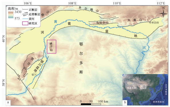
图 1 研究区构造位置图
a—研究区位置图,位于鄂尔多斯块体的西北部;b—研究区与青藏高原块体的位置
Figure 1. Tectonic position of the study area
(a) Location of the study area, which is in the northwestern margin of the Ordos Block. (b) Micro map showing the position of the study area and the Tibet Plateau Block

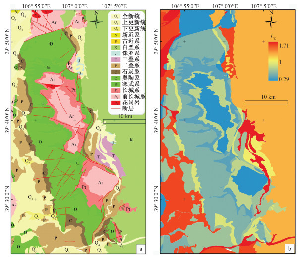
图 2 桌子山地质图与岩石的抗侵蚀强度分布图
a—桌子山地质图(据新召幅1∶20万区域地质图,1981修改);b—岩石的抗侵蚀强度分布图(LE为岩性的抗侵蚀指数)
Figure 2. Maps showing the geology and intensity of erosion resistance in the Zhuozishan area
(a) Geological map of the Zhuozishan area(Distribution of lithology and faults were modified from the 1∶200, 000 geological map of Xinzhao, 1981). (b) Intensity of erosion resistance in the Zhuozishan area(LE is the lithological erosion resistance index)

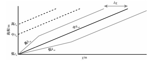
图 3 河道高程和chi(χ)值的线性关系(据Whipple et al., 2017修改)
Figure 3. Linear relationship between the channel height and chi(χ) value (modified after Whipple et al., 2017)

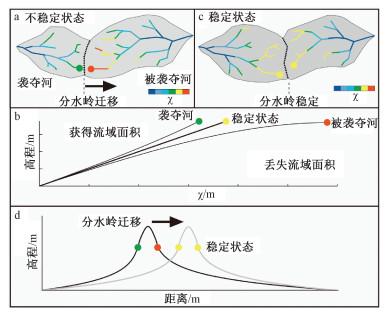
图 4 均衡和非均衡状态的流域盆地及河道chi(χ)值剖面(据Willett et al., 2014修改)
Figure 4. Drainage basins and river profiles in equilibrium and disequilibrium. The parameterχ provides a prediction of the steady-state elevation for a given point on a channel. The basin on the right (aggressor) has lower steady-state elevation at channel heads and therefore drives the drainage divide toward the basin on the left (victim). (modified after Willett et al., 2014)

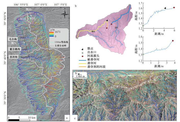
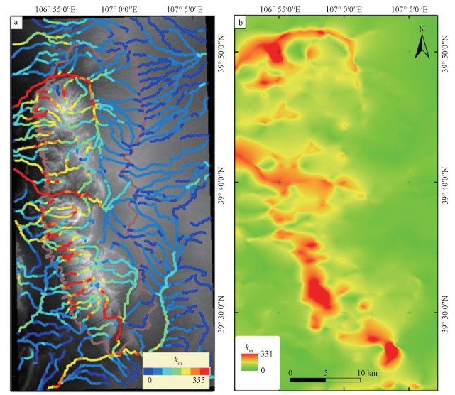
图 5 桌子山chi(χ)值分布与分水岭迁移方向
a—桌子山chi(χ)值空间分布;b—W04与E01河流袭夺的肘状拐弯和两条河流的纵剖面;c—北段南北向分水岭向东迁移的立体图(底图为Google Earth影像图)
Figure 5. Maps showing the distribution feature of the chi(χ) value and divide migration in the Zhuozishan area
(a) Chi(χ) value in the Zhuozishan area. (b) River captures evidenced by the elbows of capture and the river profile of W04, E01 in the Zhuozishan area. (c) Stereo map of the eastward migration of the main divide in the north of the Zhuozishan area (The basemap is a Google Earth image)

图 6 桌子山地区域河道陡峭指数分布图
a—桌子山河道陡峭指数分布图;b—河道陡峭指数归一后插值图
Figure 6. Diagrams showing the distribution of channel steepness index in the Zhuozishan area
(a) Distribution of the channel steepness index in the Zhuozishan area. (b) Interpolation map of the channel steepness index after normalization
表 1 岩石抗侵蚀强度分类表
Table 1. Classification of the erosion resistance values of different rocks based on the lithological strength
地层符号 岩性 岩性强度分类 地层时代 是否火成岩 LA LL LE Q4 冲积、湖积、风积砂土、粘土、砂砾 松散沉积物 第四系全新统 否 6.0 12 1.71 Q3 湖积洪积砂砾层 松散沉积物 第四系上更新统 否 6.0 11 1.62 Q2 冲洪积半固结砂层、砂土层 半固结沉积物 第四系下更新统 否 6.0 11 1.62 N 桔黄色泥质砂砾岩、细砂岩 弱的沉积岩 新近系 否 5.8 10 1.50 E 砖红色泥岩、细砂岩、砂质泥岩 弱的沉积岩 古近系 否 5.2 10 1.45 K 杂色砂岩、砂砾岩 弱的沉积岩 白垩系 否 4.2 10 1.35 J 黄绿色砂岩与泥岩互层,黑色页岩与钙质砂岩互层 弱的沉积岩 侏罗系 否 3.3 10 1.27 T 灰紫色砂岩与紫色泥岩互层、细粒长石石英砂岩 弱的沉积岩 三叠系 否 2.7 10 1.21 P 紫红色细粒砂岩、灰白色砂岩 强的沉积岩 二叠系 否 2.5 4 0.62 C 灰黑—黑色页岩、灰黑色粉砂质页岩 弱的沉积岩 石炭系 否 1.8 10 1.12 O 青灰色厚层灰岩、灰色白云质灰岩 强的沉积岩 奥陶系 否 1.2 4 0.50 
灰岩、鲕状灰岩、竹叶状灰岩 强的沉积岩 寒武系 否 1.0 4 0.48 Pt 中粒石英砂岩、紫红色页岩、白云质灰岩夹石英砂岩 强的沉积岩 长城系 否 1.0 6 0.67 Ar 黑云母斜长片麻岩 变质岩 前长城系 是 0.0 2 0.29 γ2 元古代花岗岩 花岗岩 元古代 是 0.0 2 0.29  下载: 导出CSV
-
AALTO R, DUNNE T, GUYOT J L, 2006. Geomorphic controls on Andean denudation rates[J]. The Journal of Geology, 114(1): 85-99. doi: 10.1086/498101 AGLIARDI F, CROSTA G B, FRATTINI P, et al., 2013. Giant non-catastrophic landslides and the long-term exhumation of the European Alps[J]. Earth and Planetary Science Letters, 365: 263-274. doi: 10.1016/j.epsl.2013.01.030 BISHOP P, 1995. Drainage rearrangement by river capture, beheading and diversion[J]. Progress in Physical Geography: Earth and Environment, 19(4): 449-473. doi: 10.1177/030913339501900402 BONNET S, 2009. Shrinking and splitting of drainage basins in orogenic landscapes from the migration of the main drainage divide[J]. Nature Geoscience, 2(11): 766-771. doi: 10.1038/ngeo666 CAMPFORTS B, VANACKER V, HERMAN F, et al., 2020. Parameterization of river incision models requires accounting for environmental heterogeneity: insights from the tropical Andes[J]. Earth Surface Dynamics, 8(2): 447-470. doi: 10.5194/esurf-8-447-2020 CLARK M K, SCHOENBOHM L M, ROYDEN L H, et al., 2004. Surface uplift, tectonics, and erosion of eastern Tibet from large-scale drainage patterns[J]. Tectonics, 23(1): TC1006. http://ci.nii.ac.jp/naid/10016888636 COLLIGNON M, YAMATO P, CASTELLTORT S, et al., 2016. Modeling of wind gap formation and development of sedimentary basins during fold growth: application to the Zagros Fold Belt, Iran[J]. Earth Surface Processes and Landforms, 41(11): 1521-1535. doi: 10.1002/esp.3921 DAVIS W M, 1899. The geographical cycle[J]. The Geographical Journal, 14(5): 481-504. doi: 10.2307/1774538 FORTE A M, WHIPPLE K X, 2018. Criteria and tools for determining drainage divide stability[J]. Earth and Planetary Science Letters, 493: 102-117. doi: 10.1016/j.epsl.2018.04.026 FORTE A M, WHIPPLE K X, COWGILL E, 2015. Drainage network reveals patterns and history of active deformation in the eastern Greater Caucasus[J]. Geosphere, 11(5): 1343-1364. doi: 10.1130/GES01121.1 GOREN L, WILLETT S D, HERMAN F, et al., 2014. Coupled numerical-analytical approach to landscape evolution modeling[J]. Earth Surface Processes and Landforms, 39(4): 522-545. doi: 10.1002/esp.3514 HANCOCK G S, ANDERSON R S, 2002. Numerical modeling of fluvial strath-terrace formation in response to oscillating climate[J]. GSA Bulletin, 114(9): 1131-1142. doi: 10.1130/0016-7606(2002)114<1131:NMOFST>2.0.CO;2 HOWARD A D, 1965. Geomorphological systems; equilibrium and dynamics[J]. American Journal of Science, 263(4): 302-312. doi: 10.2475/ajs.263.4.302 KANG Y Z, XING S W, LI H J, et al., 2019. Features of structural systems in northern China and its control on basin and hydrocarbon distribution[J]. Journal of Geomechanics, 25(6): 1013-1024. (in Chinese with English abstract) KIRBY E, WHIPPLE K X, 2012. Expression of active tectonics in erosional landscapes[J]. Journal of Structural Geology, 44: 54-75. doi: 10.1016/j.jsg.2012.07.009 KORUP O, CLAGUE J J, HERMANNS R L, et al., 2007. Giant landslides, topography, and erosion[J]. Earth and Planetary Science Letters, 261(3-4): 578-589. doi: 10.1016/j.epsl.2007.07.025 LIANG K, 2019. Late quaternary tectonic activity characteristics of the northwestern margin of the ordos block[D]. Beijing: Institute of Geology, China Earthquake Administrator. (in Chinese with English abstract) LIU R, MA B Q, 2014. Preliminary study on the western margin fault of Zhuozi Mountain[J]. Bulletin of the Institute of Crustal Dynamics(26): 68-82. (in Chinese with English abstract) http://en.cnki.com.cn/Article_en/CJFDTotal-SEIS201400006.htm LIU X D, SUN H, MIAO Y F, et al., 2015. Impacts of uplift of northern Tibetan Plateau and formation of Asian inland deserts on regional climate and environment[J]. Quaternary Science Reviews, 116: 1-14. doi: 10.1016/j.quascirev.2015.03.010 MAHER E, HARVEY A M, FRANCE D, 2007. The impact of a major Quaternary river capture on the alluvial sediments of a beheaded river system, the Rio Alias SE Spain[J]. Geomorphology, 84(3-4): 344-356. doi: 10.1016/j.geomorph.2005.07.034 MATHER A E, 2000. Impact of headwater river capture on alluvial system development: an example from the Plio-Pleistocene of the Sorbas Basin, SE Spain[J]. Journal of the Geological Society, 157(5): 957-966. doi: 10.1144/jgs.157.5.957 PERRON J T, ROYDEN L, 2013. An integral approach to bedrock river profile analysis[J]. Earth Surface Processes and Landforms, 38(6): 570-576. doi: 10.1002/esp.3302 PRINCE P S, SPOTILA J A, HENIKA W S, 2010. New physical evidence of the role of stream capture in active retreat of the Blue Ridge escarpment, southern Appalachians[J]. Geomorphology, 123(3-4): 305-319. doi: 10.1016/j.geomorph.2010.07.023 PRINCE P S, SPOTILA J A, HENIKA W S, 2011. Stream capture as driver of transient landscape evolution in a tectonically quiescent setting[J]. Geology, 39(9): 823-826. doi: 10.1130/G32008.1 PRITCHARD D, ROBERTS G G, WHITE N J, et al., 2009. Uplift histories from river profiles[J]. Geophysical Research Letters, 36(24): L24301. doi: 10.1029/2009GL040928 STOKES M, MATHER A E, HARVEY A M, 2002. Quantification of river-capture-induced base-level changes and landscape development, Sorbas Basin, SE Spain[J]. Geological Society, London, Special Publications, 191(1): 23-35. doi: 10.1144/GSL.SP.2002.191.01.03 TUCKER G E, SLINGERLAND R, 1997. Drainage basin responses to climate change[J]. Water Resources Research, 33(8): 2031-2047. doi: 10.1029/97WR00409 VACHERAT A, BONNET S, MOUTHEREAU F, 2017. Drainage reorganization and divide migration induced by the excavation of the Ebro basin (NE Spain)[J]. Earth Surface Dynamics Discussions, doi: 10.5194/esurf-2017-53. WHIPPLE K X, 2001. Fluvial landscape response time: how plausible is steady-state denudation?[J]. American Journal of Science, 301(4-5): 313-325. doi: 10.2475/ajs.301.4-5.313 WHIPPLE K X, FORTE A M, DIBIASE R A, et al., 2017. Timescales of landscape response to divide migration and drainage capture: Implications for the role of divide mobility in landscape evolution[J]. Journal of Geophysical Research: Earth Surface, 122(1): 248-273. doi: 10.1002/2016JF003973 WHIPPLE K X, TUCKER G E, 1999. Dynamics of the stream-power river incision model: Implications for height limits of mountain ranges, landscape response timescales, and research needs[J]. Journal of Geophysical Research: Solid Earth, 104(B8): 17661-17674. doi: 10.1029/1999JB900120 WILLETT S D, 1999. Orogeny and orography: the effects of erosion on the structure of mountain belts[J]. Journal of Geophysical Research: Solid Earth, 104(B12): 28957-28981. doi: 10.1029/1999JB900248 WILLETT S D, MCCOY S W, PERRON J T, et al., 2014. Dynamic reorganization of river basins[J]. Science, 343(6175): 1248765. doi: 10.1126/science.1248765 XU D Z, LI S H, YIN H Q, et al., 2018. Late quaternary activity characteristics of western piedmont fault of Gangdeershan in the Wuhai fault depression, Inner Mongolia[J]. China Earthquake Engineering Journal, 40(1): 92-100. (in Chinese with English abstract) http://en.cnki.com.cn/Article_en/CJFDTOTAL-ZBDZ201801015.htm YANG R, WILLETT S D, GOREN L, 2015. In situ low-relief landscape formation as a result of river network disruption[J]. Nature, 520(7548): 526-529. doi: 10.1038/nature14354 ZHAO H G, LIU C Y, WANG F, et al., 2006. Structural division and characteristics in western edge of Ordos basin[J]. Oil & Gas Geology, 2006, 27(2): 173-179. (in Chinese with English abstract) http://en.cnki.com.cn/Article_en/CJFDTOTAL-SYYT200602006.htm ZHENG W J, ZHANG P Z, YUAN D Y, et al., 2019. Basic characteristics of active tectonics and associated geodynamic processes in continental China[J]. Journal of Geomechanics, 25(5): 699-721. (in Chinese with English abstract) http://en.cnki.com.cn/Article_en/CJFDTotal-DZLX201905007.htm ZHUO Y Z, 2015. The mesozoic and cenozoic uplift events and tectonic significance of Zhuozishan area in the northwest margin of Odros basin[D]. Xi'an: Northwest University. (in Chinese with English abstract) 康玉柱, 邢树文, 李会军, 等, 2019. 中国北方地区构造体系控盆作用与控油分布规律[J]. 地质力学学报, 25(6): 1013-1024. https://journal.geomech.ac.cn/ch/reader/view_abstract.aspx?flag=1&file_no=20190602&journal_id=dzlxxb 梁宽, 2019. 鄂尔多斯块体西北缘晚第四纪构造活动特征研究[D]. 北京: 中国地震局地质研究所. 刘睿, 马保起, 2014. 桌子山西缘断裂的初步研究[J]. 地壳构造与地壳应力文集, (26): 68-82. 徐东卓, 李胜虎, 尹海权, 等, 2018. 内蒙古乌海断陷岗德尔山西麓断裂晚第四纪特征分析[J]. 地震工程学报, 40(1): 92-100. doi: 10.3969/j.issn.1000-0844.2018.01.092 赵红格, 刘池洋, 王峰, 等, 2006. 鄂尔多斯盆地西缘构造分区及其特征[J]. 石油与天然气地质, 27(2): 173-179. doi: 10.3321/j.issn:0253-9985.2006.02.006 郑文俊, 张培震, 袁道阳, 等, 2019. 中国大陆活动构造基本特征及其对区域动力过程的控制[J]. 地质力学学报, 25(5): 699-721. https://journal.geomech.ac.cn/ch/reader/view_abstract.aspx?flag=1&file_no=20190506&journal_id=dzlxxb 卓鱼周, 2015. 鄂尔多斯盆地西北部桌子山地区中-新生代隆升事件的确定及其构造意义[D]. 西安: 西北大学. -

 下载:
下载:

 点击查看大图
计量
- 文章访问数: 304
- HTML全文浏览量: 83
- PDF下载量: 39
- 被引次数: 0
