

Information construction method of geological survey projects based on digital mapping technology
-
摘要: 地质调查项目信息化建设是实现地质调查有效服务国家生态文明建设重大需求的支撑体系之一。数字填图技术是地质调查项目信息化建设中的关键技术,使得野外数据采集、数据处理、成果输出等全流程信息化得以实现。文章针对地质调查项目信息化建设过程中的技术难点,应用最新的数字填图系统平台,总结出一套简明实用的地质调查项目信息化建设方法:首先,优选符合地质调查精度要求的数据源,并采用2000国家大地坐标系;而后,运用数字填图技术系统中DGSGIS工具下载、配准所选取数据源影像作为地理底图;最后,使用数字填图系统建设完成地质调查项目空间数据库。该方法技术流程简洁、实用性强,对地质调查项目信息化建设具有一定指导意义。Abstract: The informatization construction of geological survey project is one of the supporting systems to realize the effective service of geological survey to the national ecological civilization construction. Digital mapping technology is the key technology in the informationization construction of geological survey projects, which makes the whole process of field data acquisition, data processing and output of results informationized. In view of the technical difficulties in the informatization construction of geological survey projects, a set of concise and practical informatization construction methods for geological survey projects are summarized by applying the latest digital mapping system platform. Firstly, the data sources that meet the requirements of geological survey accuracy are selected, and the 2000 national geodetic coordinate system is adopted. Then, the selected data source images are downloaded and registered by DGSGIS tools in the digital mapping technology system as the geographic base maps. Finally, the spatial database of geological survey projects is constructed by using the digital mapping system. This method is simple and practical, and has certain guiding significance for the informatization construction of geological survey projects.
-
Key words:
- informatization construction /
- digital mapping /
- geographic base map /
- coordinate system /
- geological survey /
- DGSGIS
-

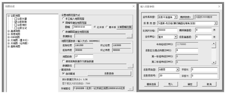
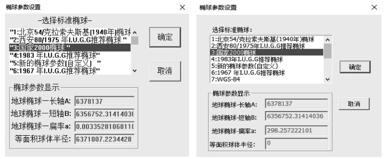
图 1 MapGIS 67以及数字填图系统中设置好2000坐标系的效果图
a—MapGIS 67中椭球参数设置图;b—数字填图系统中椭球参数设置图
Figure 1. Renderings of the 2000 national geodetic coordinate system setted in MapGIS 67 and DGSS

图 4 空间数据库建库工作流程(International Organization for Standardization, 2003; 中国地质调查局, 2006)
Figure 4. Workflow of building spatial database (IOS, 2003; China Geological Survey, 2006)
-
CARR G, ANDREW A, DENTON G, et al., 1999. The "Glass Earth"-geochemical frontiers in exploration through cover[R]. Victoria Park: Australian Institute of Geoscientists: 33-40. CHEN J P, LI J, XIE S, et al., 2017. China geological big data research status[J]. Journal of Geology, 41(3):353-366. (in Chinese with English abstract) http://d.old.wanfangdata.com.cn/Periodical/jsdz201703001 CHEN S P, LU X J, ZHOU C H, 1999. Guide of geography information system[M]. Beijing:Science Press. (in Chinese) China Geological Survey, 2006. Digital geological map spatial database: DD2006-06[S]. China Geological Survey. (in Chinese) China Geological Survey Bureau, Ministry of Natural Resources, 2019. Technical requirement for regional geological survey (1: 50 000): DD 2019-01[S]. China Geological Survey Bureau, Ministry of Natural Resources. (in Chinese) GONG J Y, 2001. Concepts and development of spatial database management[J]. Science of Surveying and Mapping, 26(3):4-9. (in Chinese with English abstract) http://en.cnki.com.cn/Article_en/CJFDTOTAL-CHKD200103001.htm HAN K Y, DING X Z, FAN B X, et al., 2005. The application of MapGIS to the construction of geological map database[J]. Acta Geoscientica Sinica, 26(6):587-590. (in Chinese with English abstract) http://en.cnki.com.cn/Article_en/CJFDTotal-DQXB200506016.htm HAN K Y, DING X Z, LI T D, et al., 2007. Progress in the construction of the spatial database of the 1:1 million Geological Map of China[J]. Geology in China, 34(2):359-364. (in Chinese with English abstract) http://en.cnki.com.cn/Article_en/CJFDTotal-DIZI200702020.htm HANSEN V L, L? PEZ I, 2018. Mapping of geologic structures in the Niobe-Aphrodite map area of Venus:unraveling the history of tectonic regime change[J]. Journal of Geophysical Research, 123(7):1760-1790. HENLEY S, 1981. Databanks and databases in geology:Journal of the Geological Society of London[J]. Computers & Geosciences, 138(8):573-630. IELSCH G, CUNEY M, BUSCAIL F, et al., 2017. Estimation and mapping of uranium content of geological units in France[J]. Journal of Environmental Radioactivity, 166:210-219. doi: 10.1016/j.jenvrad.2016.05.022 International Organization for Standardization, 2003. Geographic information-metadata: ISO 19115: 2003[S]. JIANG Z Q, 1994. A survey of geoscience digital mapping technology in the United States, Canada, Australia and the United Kingdom[J]. Chinese Geology(12):27-29. (in Chinese) JIANG Z Q, 2000. The status and technical development of capturing techniques of field geologic data[J]. Geological Survey Information(6):95-109. (in Chinese with English abstract) JIANG Z Q, MA Z M, YANG D L, et al., 2007. The policy systems of geological information services in main developed countries and its characteristics[J]. Geological Bulletin of China, 26(3):350-354. (in Chinese with English abstract) http://en.cnki.com.cn/Article_en/CJFDTOTAL-ZQYD200703012.htm JONES C B, BUNDY G L, WARE M J, 1995. Map generalization with a triangulated data structure[J]. Cartography and Geographic Information Systems, 22(4):317-331. http://www.wanfangdata.com.cn/details/detail.do?_type=perio&id=10.1559/152304095782540221 LANCIANESE V, DINELLI E, 2016. Geochemical mapping based on geological units:a case study from the Marnoso-arenacea formation (Northern Apennines, Italy)[J]. Geochemistry, 76(1):49-62. doi: 10.1016/j.chemer.2015.12.001 LI C L, 2011. Digital geology survey system[M]. Beijing:Geological Publishing House. (in Chinese) LI C L, ZHANG K X, QIANG F Z, et al., 2002. Research on digital regional geologic survey system techniques[J]. Advance in Earth Sciences, 17(5):763-768. (in Chinese with English abstract) LI F D, LI C L, WU L, et al., 2015. Data integration and services of digital geological mapping based on big data[J]. Geological Bulletin of China, 34(7):1300-1308. (in Chinese with English abstract) http://www.wanfangdata.com.cn/details/detail.do?_type=perio&id=zgqydz201507007 LI Y W, 1998. Development of spatial information technology and its applications in Geosciences[J]. Earth Science Frontiers, 5(1-2):335-341. (in Chinese with English abstract) NÉMETH K, PALMER J, 2019. Geological mapping of volcanic terrains:discussion on concepts, facies models, scales, and resolutions from New Zealand perspective[J]. Journal of Volcanology and Geothermal Research, 385:27-45. doi: 10.1016/j.jvolgeores.2018.11.028 REN J S, NIU B G, WANG J, et al., 2013. Advances in research of Asian geology-A summary of 1:5M international geological map of Asia project[J]. Journal of Asian Earth Sciences, 72:3-11. https://www.sciencedirect.com/science/article/abs/pii/S1367912013000928 REN J S, NIU B G, ZHAO L, et al, 2019. Basic ideas of the multisphere tectonics of earth system[J]. Journal of Geomechanics, 25(5):607-612. (in Chinese with English abstract) http://d.old.wanfangdata.com.cn/Periodical/dzlxxb201905003 SOLLER D R, BERG T M, 2005. The U.S. national geologic map database project: overview & progress[C]//Proceedings of NATO advanced research workshop on innovative applications of GIS in geological cartography kazimierz dolny. Poland: Springer: 245-277. STAMM N, 2008. Incorporating biostratigraphic information into the US national geologic map database[J]. National Geologic Map Database. 22-28. WU C L, LIU G, ZHANG X L, et al., 2016. Discussion on geological science big data and its applications[J]. Chinese Science Bulletin, 61(16):1797-1807. (in Chinese with English abstract) doi: 10.1360/N972015-01035 YANG X C, YE P S, CAI M T, et al., 2017. Methods for the production of field free-hand maps and geographic basemaps in digital geological mapping[J]. Journal of Geomechanics, 23(3):333-338. (in Chinese with English abstract) http://www.wanfangdata.com.cn/details/detail.do?_type=perio&id=dzlxxb201703001 YE T Z, HUANG C K, DENG Z Q, 2017. Spatial database of 1:2500000 digital geologic map of People's Republic of China[J]. Geology in China, 44(S1):19-24. (in Chinese with English abstract) YU Q W, LI C L, ZHANG K X, et al., 2003. Digital geological mapping and its development[J]. Earth Science-Journal of China University of Geosciences, 28(4):370-376. (in Chinese with English abstract) http://d.old.wanfangdata.com.cn/Periodical/dqkx200304002 ZHENG X, LI J C, WANG X, et al., 2015. Construction of the national geological information service system in the age of big data[J]. Geological Bulletin of China, 34(7):1316-1322. (in Chinese with English abstract) 陈建平, 李靖, 谢帅, 等, 2017.中国地质大数据研究现状[J].地质学刊, 41(3):353-366. http://www.wanfangdata.com.cn/details/detail.do?_type=perio&id=jsdz201703001 陈述彭, 鲁学军, 周成虎, 1999.地理信息系统导论[M].北京:科学出版社. 龚健雅, 2001.空间数据库管理系统的概念与发展趋势[J].测绘科学, 26(3):4-9. doi: 10.3771/j.issn.1009-2307.2001.03.002 韩坤英, 丁孝忠, 范本贤, 等, 2005. MapGIS在建立地质图数据库中的应用[J].地球学报, 26(6):587-590. doi: 10.3321/j.issn:1006-3021.2005.06.017 韩坤英, 丁孝忠, 李廷栋, 等, 2017.全国1:100万地质图空间数据库建设进展[J].中国地质, 34(2):359-364. http://d.old.wanfangdata.com.cn/Periodical/sbglywx201401059 姜作勤, 1994.美、加、澳、英等国地学数字制图技术综述[J].中国地质(12):27-29. http://www.wanfangdata.com.cn/details/detail.do?_type=perio&id=QK199400034406 姜作勤, 2000.野外地质数据采集信息化现状与技术发展[J].地质调查情报(6):95-109. 姜作勤, 马智民, 杨东来, 等, 2007.主要发达国家地质信息服务的政策体系及其特点[J].地质通报, 26(3):350-354. doi: 10.3969/j.issn.1671-2552.2007.03.013 李超岭, 张克信, 墙芳躅, 等, 2002.数字区域地质调查系统技术研究[J].地球科学进展, 17(5):763-768. doi: 10.3321/j.issn:1001-8166.2002.05.020 李超岭, 2011.数字地质调查系统操作指南[M].北京:地质出版社. 李丰丹, 李超岭, 吴亮, 等, 2015.大数据环境下数字填图数据集成服务技术[J].地质通报, 34(7):1300-1308. doi: 10.3969/j.issn.1671-2552.2015.07.007 李裕伟, 1998.空间信息技术的发展及其在地球科学中的应用[J].地学前缘, 5(1-2):335-341. http://www.cnki.com.cn/Article/CJFDTotal-DXQY802.027.htm 任纪舜, 牛宝贵, 赵磊, 等, 2019.地球系统多圈层构造观的基本内涵[J].地质力学学报, 25(5):607-612. http://journal.geomech.ac.cn/ch/reader/view_abstract.aspx?file_no=20190502&flag=1 吴冲龙, 刘刚, 张夏林, 等, 2016.地质科学大数据及其利用的若干问题探讨[J].科学通报, 61(16):1797-1807. http://www.wanfangdata.com.cn/details/detail.do?_type=perio&id=kxtb201616010 杨星辰, 叶培盛, 蔡茂堂, 等, 2017.数字地质填图野外手图地理底图制作方法[J].地质力学学报, 23(3):333-338. doi: 10.3969/j.issn.1006-6616.2017.03.001 叶天竺, 黄崇轲, 邓志奇, 2017. 1:250万中华人民共和国数字地质图空间数据库[J].中国地质, 44(S1):19-24. http://d.old.wanfangdata.com.cn/OAPaper/oai_doaj-articles_312d799abfb4a74ea247d6e73a15df1a 于庆文, 李超岭, 张克信, 等, 2003.数字地质填图研究现状与发展趋势[J].地球科学:中国地质大学学报, 28(4):370-376. http://d.old.wanfangdata.com.cn/Periodical/dqkx200304002 郑啸, 李景朝, 王翔, 等, 2015.大数据背景下的国家地质信息服务系统建设[J].地质通报, 34(7):1316-1322. doi: 10.3969/j.issn.1671-2552.2015.07.009 中国地质调查局, 2006.数字地质图空间数据库: DD2006-06[S].中国地质调查局. 自然资源部中国地质调查局, 2019.区域地质调查技术要求(1: 50000): DD 2019-01[S].自然资源部中国地质调查局. -

 下载:
下载:


 点击查看大图
图(4)
计量
- 文章访问数: 216
- HTML全文浏览量: 57
- PDF下载量: 10
- 被引次数: 0
