

Study on the river network, geomorphological features and tectonic activity in the Danjiangkou reservoir and its surrounding areas
-
摘要: 河流作为构造-气候相互作用最为敏感的地貌单元,记录了丰富的水系演化、构造变形以及气候变化等信息。通过研究河流的形成与演化过程来阐述区域地貌和构造活动特征是构造地貌研究的一个突破点,河流形态的空间变化是阐述河流形成与演化特征最为直观有效的方法。丹江口水库库区地貌特征复杂、地质灾害频发、差异性构造活动较为强烈,是开展构造地貌研究的理想场所。通过对丹江口水库库区及周边地区河流形态特征、地貌特征及构造活动特征等进行综合分析发现,河网分维值空间特征与区域内构造活动性较强的断裂的空间分布高度吻合,构造活动性较强的断裂带及周边地区,河网受到构造活动的影响,发育不成熟,河网分维值出现低值,分维值均小于1.115;构造活动性较弱的断裂带及周边地区,河网发育过程中未受到构造活动的影响,发育较成熟,河网分维值高,分维值均大于1.25;而河网分维值空间变化与地形坡度、平均高程等地貌参数相关性不显著。因此,区域构造活动性特征是河网形态空间变化控制的关键因素。利用河网形态的分维特征量化区域构造活动的强弱及各区域构造活动的差异,对于河流的形成与演化、构造活动性及预测地质灾害的发生等方面的研究都有一定的参考价值。Abstract: Owing to its sensitiveness to tectonics and climate, river records the relevant information about river system evolution, structural deformation and climate change. It is a breakthrough point in structural geomorphology research to elaborate on regional geomorphology and tectonic activities by studying the formation and evolution of the river, while the most direct and effective way to study formation and evolution of the river is through the spatial change of river morphology. Complex geomorphology, frequently-happened geological disasters, and strong tectonic activities make the Danjiangkou reservoir an ideal place for structural geomorphology research. In this paper, we researched on the river morphology, geomorphology and tectonic activities in the surrounding areas of the Danjiangkou reservoir. It is shown that the spatial characteristics of the river network fractal dimension values are highly consistent with the spatial distribution of the regional active faults. In and around the relatively active fault zones, the river networks are affected by tectonic activities in the process of development. The evolution of the river is immature and the river network fractal dimension values are relatively low (below 1.115). On the contrary, in and around the relatively inactive fault zones, the evolution of the river is mature, and the river network fractal dimension values are relatively high(above 1.25). Moreover, there is no significant correlation between the spatial distribution of river network fractal dimension values and geomorphological parameters, such as topographic slope and average elevation, which means the crucial factor affecting the spatial distribution of river network is the regional tectonic activity. Therefore, characteristics of river network fractal dimension can quantitatively reflect the strength and difference of regional tectonic activities, which provides reference for the studies on river formation and evolution, tectonic activity and prediction of geological disasters.
-

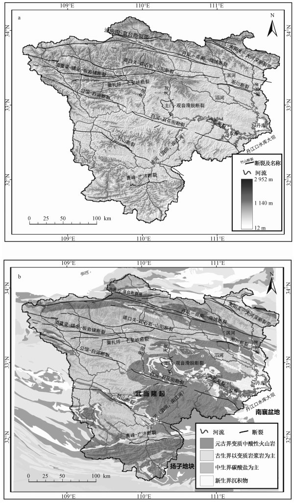
图 1 研究区地质地貌特征与活动构造分布图
a—区域高程分布叠加山影图;b—区域地质图
Figure 1. Schematic diagram of geological and geomorphological characteristics and the distribution of active structures in the study area

图 2 研究区内地震记录、地质灾害事件、河网分形维数的空间分布
a—子流域河网分维特征分布;b—利用ARCGIS空间分析模块对每一个集水子区域进行几何中心分析及赋值并插值平滑处理后河网分维特征的空间分布F1—青峰-广济断裂;F2—竹山断裂;F3—公馆-白河-石花街断裂;F4—粟扎坪-七里峡断裂;F5—土门-观音滑脱断裂;F6—两郧断裂;F7—靖口关-花石岩-山阳断裂;F8—淅川断裂;F9—丹凤-商南-商城断裂;F10—朱阳关-大河深断裂
Figure 2. Spatial distribution of the earthquakes, geological hazards, river network fractal dimension values in the study area

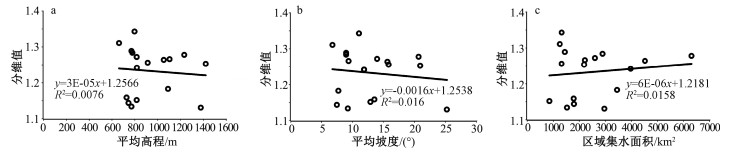
图 3 丹江口水库库区周边地区水系河网分维值与地貌特征的相关关系
a—子集水区域河网分维值与平均高程的相关关系;b—子集水区域河网分维值与平均坡度的相关关系;c—子集水区域河网分维值与区域集水面积的相关关系
R—相关系数;E—科学计数符号Figure 3. Correlation between river network fractal dimension value and geomorphological characteristics in the surrounding areas of the Danjiangkou reservoir

图 4 公路断裂(白河—石花街断裂)野外露头测量与空间几何关系示意图
a—公路断裂石花段断层三角面远景,镜向南;b—石花断裂近景实地产状测量,镜向东;c—公路断裂地层地下空间几何模式
Figure 4. Relation diagram of spatial geometry and field measurement of the outcrop in the Gonglu fault (Baihe-Shihuajie fault)
表 1 丹江口水库库区周边地区水系河网分维值及地貌指标
Table 1. River network fractal dimension values and geomorphological indexes in the surrounding areas of the Danjiangkou reservoir
子流域编号[代码] 区域面积/km2 平均高程/m 平均坡度/(°) 分维值 1[a] 3449 1091 7.7 1.183 2[b] 3971 819 11.85 1.242 3[c] 2896 779 8.96 1.284 4[d] 1450 771 8.96 1.289 5[e] 6305 1233 20.66 1.278 6[f] 4524 1054 15.62 1.264 7[g] 2218 1105 9.35 1.266 8[h] 1799 745 7.46 1.144 9[i] 1252 662 6.75 1.311 10[j] 2602 817 13.95 1.272 11[k] 1789 728 13.52 1.159 12[l] 1325 798 11.03 1.343 13[m] 851 817 12.87 1.152 14[n] 1320 913 15.81 1.256 15[o] 1533 771 9.23 1.134 16[p] 2192 1421 20.91 1.253 17[q] 2963 1378 25.22 1.131 18[r] 6578 838 9.35 1.132  下载: 导出CSV
表 2 丹江口水库库区周边地区地震目录(引自《中国历史强震目录(公元前23世纪—公元1911年)》和美国USGS提供的地震记录)
Table 2. Earthquake catalog in the surrounding areas of the Danjiangkou reservoir (quoted from the "Catalogue of Chinese History(23rd Century BC-1911 AD)" and seismic records provided by USGS in the United States)
编号 时间 经度/(°) 纬度/(°) 震级/ Ms 震源深度/km 1 公元前143年 110.1 32.1 5 无记录 2 788年 109.9 32.4 6.5 无记录 3 1868年 109.7 32.8 5.5 无记录 4 1632年 109.7 32.4 5 无记录 5 1887年 111.0 32.4 4.8 无记录 6 2014年5月27日 110.205 31.956 4.5 21.7 7 2008年3月27日 110.31 32.569 4.8 10 8 2008年3月24日 110.193 32.525 4.3 10
下载: 导出CSV
表 3 丹江口水库库区及周边地区地质灾害目录
Table 3. Geological hazards catalog in the surrounding areas of the Danjiangkou reservoir
序号 时间 经度/(°) 纬度/(°) 灾害类型 灾害规模 1 2006年1月—3月 110.517 32.691 滑坡 中小型 2 2006年1月—3月 110.569 32.801 滑坡 中小型 3 2008年1月—3月 110.67 32.635 滑坡 中小型 4 2008年1月—3月 110.308 31.556 滑坡 中小型 5 2009年1月—3月 109.69 33.88 滑坡 中小型 6 2010年1月—3月 109.621 32.664 崩塌 中小型 7 2011年1月—3月 110.655 32.65 滑坡 中小型 8 2015年1月—3月 110.655 32.65 滑坡 中小型 9 2016年1月—3月 110.293 31.571 滑坡 中小型 10 2016年1月—3月 109.776 31.872 滑坡 中小型 11 2016年1月—3月 110.207 32.158 滑坡 中小型 12 2016年1月—3月 110.19 31.749 崩塌 大型 13 2017年1月—3月 110.741 32.623 滑坡 大型 14 2017年1月—3月 109.759 32.842 崩塌 中小型
下载: 导出CSV
-
BAI Y J, NI H Y, GE H, 2019. Research on the Geohazard effect of active fault on the eastern margin of the Tibetan Plateau[J]. Journal of Geomechanics, 25(6):1116-1128. (in Chinese with English abstract) http://www.wanfangdata.com.cn/details/detail.do?_type=perio&id=dqxb201603003 Bureau of Geology and Mineral Resources of Hubei Province, 1990. Regional geological records of Hubei Province.[M]. Beijing:Geology Press. (in Chinese) CAO X W, MA X M, GONG S Y, et al., 2018. A study on distribution characteristics and activity of north-west faults in Shenzhen[J]. Journal of Geomechanics, 24(6):759-767. (in Chinese with English abstract) http://d.old.wanfangdata.com.cn/Periodical/dzlxxb201806003 FENG P, FENG Y, 1997. Calculation on fractal dimension of river morphology[J]. Acta Geographica Sinica, 52(4):324-330. (in Chinese with English abstract) doi: 10.11821/xb199704005 HULL D, 1996. Interpretation of river line patterns on indentation generated fracture surfaces with comments on the fractal characteristics described by Djordjevic et al[J]. Journal of Materials Science Letters, 15(8):651-653. doi: 10.1007/BF00264102 KONG F C, DING G Y, 1991. Fractal geometric analysis of drainage and loess gullly systems in Shanxi and its adjacent areas[J]. Seismology and Geology, 13(3):221-229. (in Chinese with English abstract) LI B B, LI Z B, LI P, 2015. Spatial and temporal variation characteristics of vegetation cover fractal dimension in Dali River watershed based on GIS and RS[J]. Transactions of the Chinese Society of Agricultural Engineering, 31(12):173-178. (in Chinese with English abstract) http://www.wanfangdata.com.cn/details/detail.do?_type=perio&id=nygcxb201512023 LIU C Z, 1993. The segregative characterisistics of active fault system and its fractal geometry[J]. Hydrogeology and Engineering Geology(6):16-19. (in Chinese with English abstract) LIU Y H, XU Y M, 2015. Urban spatial expansion of Beijing based on city fractal[J]. Science of Surveying and Mapping, 40(10):30-36. (in Chinese with English abstract) http://d.old.wanfangdata.com.cn/Periodical/chkx201510006 MANDELBROT B B, 1983. The fractal geometry of nature[M]. New York:WH Freeman and Company. MESA O J, GUPTA V K. 1987. On the main channel length-area relationship for channel networks[J]. Water Resource Research, 23(11):2119-2122. doi: 10.1029/WR023i011p02119 NING K B, LI Y H, HE Q, et al., 2018. The spatial and temporal distribution and trend of geological disaster in Shaanxi Province from 2000 to 2016[J]. The Chinese Journal of Geological Hazard and Control, 29(1):93-101. (in Chinese with English abstract) http://d.old.wanfangdata.com.cn/Periodical/zgdzzhyfzxb201801015 PENG L, XU S N, PENG J H, 2014. Research on development characteristics and size of landslides in the Three Gorges area[J]. Geoscience, 28(5):1077-1086. (in Chinese with English abstract) http://www.wanfangdata.com.cn/details/detail.do?_type=perio&id=xddz201405025 QIN Y C, LIU K, 2003. Advancement of applied studies of fractal theory in geography[J]. Progress in Geography, 22(4):426-436. (in Chinese with English abstract) http://www.wanfangdata.com.cn/details/detail.do?_type=perio&id=dlkxjz200304011 QIU H J, CAO M M, LIU W, et al., 2014. Research on variable dimension fractal characteristics of spatial distribution of landslide[J]. Geoscience, 28(2):443-448. (in Chinese with English abstract) http://en.cnki.com.cn/Article_en/CJFDTOTAL-XDDZ201402024.htm RODRIGUEZ-ITURBE I, RINALDO A, RIGON R, et al., 1992. Fractal structures as least energy patterns:the case of river networks[J]. Geophysical Research Letters, 19(9):889-892. doi: 10.1029/92GL00938 SHEN X H, ZOU L J, YANG F, et al., 2001. Relationship between Yangzte riverway fractal and geological structure of the catchment[J]. Journal of Zhejiang University (Science Edition), 28(1):107-111. (in Chinese with English abstract) http://www.wanfangdata.com.cn/details/detail.do?_type=perio&id=zjdxxb200101019 SHEN X H, ZOU L J, ZHANG G F, et al., 2011. Fractal characteristics of the main channel of Yellow River and its relation to regional tectonic evolution[J]. Geomorphology, 127(1-2):64-70. doi: 10.1016/j.geomorph.2010.12.007 SHEN Y C, GONG G Y, 1986. A theory of river geomorphology[M]. Beijing:Science Press. (in Chinese) SHI F, HE H L, DENSMORE A L, et al., 2016. Research on the relationship between fractal factors and tectonic activity-a case study of southwestern Yunnan block[J]. Seismology and Geology, 38(4):862-873. (in Chinese with English abstract) TAN K X, HAO X C, DAI T G, 1998. Fractal features of fractures in China and their implication for geotectonics[J]. Geotectonica et Metallogenia, 22(1):17-20. (in Chinese with English abstract) http://en.cnki.com.cn/Article_en/CJFDTOTAL-DDGZ1997Z2004.htm The Earthquake Prevention Department of the National Seismological Bureau, 1995. The historical catalogues on strong earthquakes in China (from 23th-century B. C. to 1911)[M]. Beijing:Seismological Press. (in Chinese) WANG H B. 1996. The fractal structur features of the active faults in the upper reaches of the Qingjiang River, and the adjacent regions western Hubei[J]. Journal of Geomechanics, 2(4):1-6. (in Chinese with English abstract) http://www.wanfangdata.com.cn/details/detail.do?_type=perio&id=QK199600065230 WANG L, CHEN X W, 2007. Study on reationship between extracted river network and fraetal dimension based on DEM[J]. Geo-information Science, 9(4):133-137. (in Chinese with English abstract) http://www.wanfangdata.com.cn/details/detail.do?_type=perio&id=dqxxkx200704024 WANG Y Z, ZHANG H P, ZHEN D W, et al., 2016. Stream-power incision model and its implications:discussion on the urgency of studying bedrock channel across the Tibetan Plateau[J]. Quaternary Sciences, 36(4):884-897. (in Chinese with English abstract) WEN L, WEI P F, CHANG H J, et al., 2018. A study of the coupling relationship between fractal characteristics of river, geomorphology and tectonic activity in areas around the Tibetan Plateau[J]. Geological Bulletin of China, 37(6):965-974. (in Chinese with English abstract) http://www.wanfangdata.com.cn/details/detail.do?_type=perio&id=zgqydz201806001 XU Q, HUANG R Q, WANG L G, 2002. Mechanism analysis on geological hazards triggered by external disturbance[J] Chinese Journal of Rock Mechanics and Engineering, 21(2):280-284. http://www.wanfangdata.com.cn/details/detail.do?_type=perio&id=yslxygcxb200202025 XU Z B, XIE H P, 2004. Relation between fracture-scale fractal distribution and its damage evolution[J]. Journal of Geomechanics, 10(3):268-275. (in Chinese with English abstract) http://www.wanfangdata.com.cn/details/detail.do?_type=perio&id=dzlxxb200403008 YANG H, LIU X L, 2015. Landscape patch scale effect based on fractal theory in Honghe county of Yunnan province[J]. Chinese Journal of Ecology, 34(9):2636-2644. (in Chinese with English abstract) http://d.old.wanfangdata.com.cn/Periodical/stxzz201509034 ZHANG C S, ZHANG Y C, HU J J, et al., 2000. Spatial and temporal distribution characteristics and forming conditions of Chinese geological disasters[J]. Quaternary Sciences, 20(6):559-566. (in Chinese with English abstract) http://www.wanfangdata.com.cn/details/detail.do?_type=perio&id=dsjyj200006008 ZHANG H P, YANG N, ZHANG Y Q, et al., 2006. Geomorphology of the Minjiang drainage system (Sichuan, China) and its structural implications[J]. Quaternary Sciences, 26(1):126-135. (in Chinese with English abstract) http://www.wanfangdata.com.cn/details/detail.do?_type=perio&id=dsjyj200601016 ZHANG H P, ZHANG P Z, WU Q L, et al., 2008. Characteristics of the Huanghe river longitudinal profiles around Xunhua-Guide area (NE Tibet) and their tectonic significance[J]. Quaternary Sciences, 28(2):299-309. (in Chinese with English abstract) http://www.wanfangdata.com.cn/details/detail.do?_type=perio&id=dsjyj200802012 ZHANG J, BAO H S, 1994. Fractal geomorphology-review and propect[J]. Geographical Research, 13(3):104-112. (in Chinese with English abstract) http://www.wanfangdata.com.cn/details/detail.do?_type=perio&id=dlyj199403013 ZHANG K C, QU J J, ZU R P, et al., 2008. Fractal characteristics of the river landscape elements[J]. Environmental Geology, 54(2):411-416. doi: 10.1007/s00254-007-0827-2 ZHANG P Z, XU X W, WEN X Z, et al., 2008. Slip rates and recurrence intervals of the Longmen Shan active fault zone and tectonic implications for the mechanism of the May 12 Wenchuan earthquake, 2008, Sichuan, China[J]. Chinese Journal of Geophysics, 51(4): 1066-1073. (in Chinese with English abstract) ZHANG S F, WANG Y F, JIA B, et al., 2017. Spatial-temporal changes and influencing factors of geologic disasters from 2005 to 2016 in China[J]. Journal of Geo-information Science, 19(12):1567-1574. (in Chinese with English abstract) http://www.wanfangdata.com.cn/details/detail.do?_type=perio&id=dqxxkx201712003 ZHANG Z R, MAO H H, 2000. Fractal theory and ore-forming[J]. Earth Science Frontiers, 7(1):195-204. (in Chinese with English abstract) http://d.old.wanfangdata.com.cn/Periodical/dxqy200001019 ZHOU X G, SUN B S, LIU J H, 1997. Fractal characteristics of fault systems and its relation to oil-gas traps in Kerkang oil field of Liaohe basin[J]. Journal of Geomechanics, 3(1):81-87. (in Chinese with English abstract) ZHU X H, 1999. Fractal analysis of mountain ranges and faults in China[J]. Journal of Geomechanics, 5(2):45-50. (in Chinese with English abstract) http://www.wanfangdata.com.cn/details/detail.do?_type=perio&id=dzlxxb199902007 ZHUANG Z F, JIANG G H, HE X, et al., 2015. Study on spatial structure and form of rural residential based on fractal theory:a case study on Pinggu District in Beijing[J]. Journal of Natural Resources, 30(9):1534-1546. (in Chinese with English abstract) 白永健, 倪化勇, 葛华, 2019.青藏高原东南缘活动断裂地质灾害效应研究现状[J].地质力学学报, 25(6):1116-1128. http://journal.geomech.ac.cn/ch/reader/view_abstract.aspx?file_no=20190613&flag=1 曹新文, 马秀敏, 龚淑云, 等, 2018.深圳北西向断裂分布特征及其活动性研究[J].地质力学学报, 24(6):759-767. http://journal.geomech.ac.cn/ch/reader/view_abstract.aspx?file_no=20180603&flag=1 冯平, 冯焱, 1997.河流形态特征的分维计算方法[J].地理学报, 52(4):324-330. doi: 10.3321/j.issn:0375-5444.1997.04.005 国家地震局震害防御司, 1995.中国历史强震目录(公元前23世纪-公元1911年)[M].北京:地震出版社. 湖北省地质矿产局, 1990.湖北省区域地质志[M].北京:地质出版社. 孔凡臣, 丁国瑜, 1991.山西及邻区水系与黄土冲沟的分形几何学分析结果及其与构造活动的关系[J].地震地质, 13(3):221-229. http://www.cnki.com.cn/Article/CJFDTotal-DZDZ199103004.htm 李斌斌, 李占斌, 李鹏, 2015.基于GIS与RS的大理河流域植被格局分形维数时空变化特征[J].农业工程学报, 31(12):173-178. doi: 10.11975/j.issn.1002-6819.2015.12.023 刘传正, 1993.活动断裂系统的分段性及其分形几何特征[J].水文地质工程地质(6):16-19. http://www.cnki.com.cn/Article/CJFDTotal-SWDG199306004.htm 刘勇洪, 徐永明, 2015.利用分形的北京城市空间拓展分析[J].测绘科学, 40(10):30-36. http://d.old.wanfangdata.com.cn/Periodical/chkx201510006 宁奎斌, 李永红, 何倩, 等, 2018. 2000~2016年陕西省地质灾害时空分布规律及变化趋势[J].中国地质灾害与防治学报, 29(1):93-101. http://d.old.wanfangdata.com.cn/Periodical/zgdzzhyfzxb201801015 彭令, 徐素宁, 彭军还, 2014.三峡库区滑坡规模与发育特征研究[J].现代地质, 28(5):1077-1086. doi: 10.3969/j.issn.1000-8527.2014.05.025 秦耀辰, 刘凯, 2003.分形理论在地理学中的应用研究进展[J].地理科学进展, 22(4):426-436. doi: 10.3969/j.issn.1007-6301.2003.04.011 邱海军, 曹明明, 刘闻, 等, 2014.区域滑坡空间分布的变维分形特征研究[J].现代地质, 28(2):443-448. doi: 10.3969/j.issn.1000-8527.2014.02.024 沈晓华, 邹乐君, 阳峰, 等, 2001.长江河道分形与流域构造特征的关系[J].浙江大学学报(理学版), 28(1):107-111. doi: 10.3321/j.issn:1008-9497.2001.01.019 沈玉昌, 龚国元, 1986.河流地貌学概论[M].北京:科学出版社. 石峰, 何宏林, DENSMORE A L, 等, 2016.二维分形参数与构造活动关系研究:以滇西南块体为例[J].地震地质, 38(4):862-873. doi: 10.3969/j.issn.0253-4967.2016.04.005 谭凯旋, 郝新才, 戴塔根, 1998.中国断裂构造的分形特征及其大地构造意义[J].大地构造与成矿学, 22(1):17-20. doi: 10.1002-hipo.20602/ 汪华斌, 1996.鄂西清江上游及邻区活动断裂分形结构特征[J].地质力学学报, 2(4):1-6. http://journal.geomech.ac.cn/ch/reader/view_abstract.aspx?file_no=19960470&flag=1 王林, 陈兴伟, 2007.基于DEM的流域水系分维计算与结果分析[J].地球信息科学, 9(4):133-137. doi: 10.3969/j.issn.1560-8999.2007.04.024 王一舟, 张会平, 郑德文, 等, 2016.基岩河道河流水力侵蚀模型及其应用:兼论青藏高原基岩河道研究的迫切性[J].第四纪研究, 36(4):884-897. http://d.old.wanfangdata.com.cn/Periodical/dsjyj201604009 文力, 魏鹏飞, 常华进, 等, 2018.青藏高原周边地区河流分形特征与地貌、构造活动耦合关系[J].地质通报, 37(6):965-974. http://d.old.wanfangdata.com.cn/Periodical/zgqydz201806001 许强, 黄润秋, 王来贵, 2002.外界扰动诱发地质灾害的机理分析[J].岩石力学与工程学报, 21(2):280-284. doi: 10.3321/j.issn:1000-6915.2002.02.025 徐志斌, 谢和平, 2004.断裂尺度的分形分布与其损伤演化的关系[J].地质力学学报, 10(3):268-275. doi: 10.3969/j.issn.1006-6616.2004.03.008 杨欢, 刘学录, 2015.基于分形理论的云南红河县景观斑块尺度效应[J].生态学杂志, 34(9):2636-2644. http://www.wanfangdata.com.cn/details/detail.do?_type=perio&id=stxzz201509034 张春山, 张业成, 胡景江, 等, 2000.中国地质灾害时空分布特征与形成条件[J].第四纪研究, 20(6):559-566. doi: 10.3321/j.issn:1001-7410.2000.06.008 张会平, 杨农, 张岳桥, 等, 2006.岷江水系流域地貌特征及其构造指示意义[J].第四纪研究, 26(1):126-135. doi: 10.3321/j.issn:1001-7410.2006.01.016 张会平, 张培震, 吴庆龙, 等, 2008.循化-贵德地区黄河水系河流纵剖面形态特征及其构造意义[J].第四纪研究, 28(2):299-309. doi: 10.3321/j.issn:1001-7410.2008.02.012 张捷, 包浩生, 1994.分形理论及其在地貌学中的应用:分形地貌学研究综述及展望[J].地理研究, 13(3):104-112. doi: 10.3321/j.issn:1000-0585.1994.03.013 张培震, 徐锡伟, 闻学泽, 等, 2008. 2008年汶川8.0级地震发震断裂的滑动速率、复发周期和构造成因[J].地球物理学报, 51(4):1066-1073. doi: 10.3321/j.issn:0001-5733.2008.04.015 章诗芳, 王玉芬, 贾蓓, 等, 2017.中国2005-2016年地质灾害的时空变化及影响因素分析[J].地球信息科学学报, 19(12):1567-1574. http://d.old.wanfangdata.com.cn/Periodical/dqxxkx201712003 张哲儒, 毛华海, 2000.分形理论与成矿作用[J].地学前缘, 7(1):195-204. doi: 10.3321/j.issn:1005-2321.2000.01.019 周新桂, 孙宝珊, 刘金红, 1997.辽河科尔康油田断裂分形特征与油气关系[J].地质力学学报, 3(1):81-87. http://journal.geomech.ac.cn/ch/reader/view_abstract.aspx?file_no=19970111&flag=1 朱晓华, 1999.中国大陆山系、断层系的分形分维探讨[J].地质力学学报, 5(2):45-50. doi: 10.3969/j.issn.1006-6616.1999.02.007 庄至凤, 姜广辉, 何新, 等, 2015.基于分形理论的农村居民点空间特征研究:以北京市平谷区为例[J].自然资源学报, 30(9):1534-1546. http://d.old.wanfangdata.com.cn/Periodical/gtzykjgl201801009 -

 下载:
下载:


 点击查看大图
计量
- 文章访问数: 335
- HTML全文浏览量: 70
- PDF下载量: 39
- 被引次数: 0
