Abstract:
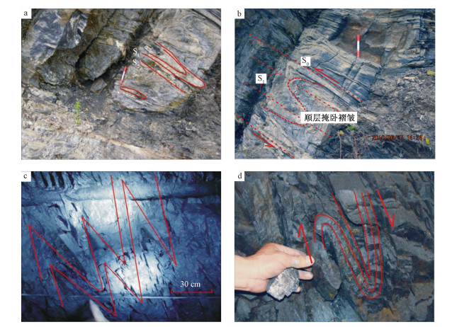
The Xitieshan deposit,one of the large-size lead-zinc deposits located at the northern edge of the Qaidam basin in western China,is related to marine Volcanic-Sedimentary Hosted Massive Sulfur deposit (VSHMS). Most prior researches are focused on the mineralization age,the nature of ore-forming fluid,and the genesis of the deposit by the method of petrology,geochemistry,and isotopic dating. However,the characteristics of ore-controlling structures,which are essential to prospecting and expanding the mining resources,have been controversial for long time,and it is generally believed that it was the fold that controlled the production of ore bodies in the deposit. This paper mainly presents field evidences to discuss the characteristics of folds and faults and its controlling roles to the distribution of ore bodies,and further to provide the basis for the mining prospecting exploration. Our field investigation and comparative analysis showed that there was no large-scale syncline or anticline in the deposit and only a monocline composed of the Ordovician Tanjianshan Group in general,although some interlayered folds were well developed,including A-and B-type. Both the fold hinge and the strench lineation of A-type fold in a-segment of the Ordovician Tanjianshan Group are dipping to SE-ward,consistent with the dipping tendency of the whole ore-bodies in the deposit,but different with those in d-segment of the Tanjianshan Group as dipping to NW-ward. There are six large-scale NWW-trending faults in the deposit,named as F1 to F6 from the northeast to southwest. The F1 fault in the deposit probably developed on the base of ductile deformation in early stage. And the latterly nappe thrusting of the fault resulted in the reverse of ore-bodies and host rocks near the fault. Large-scale sinistral strike-slipping faulting of the F2 fault played important roles on the convergence together of different segments of the Tanjianshan Group,and also the missing of some ore-bearing geological bodies. Field mapping between the Zhongjiangou and Wuminggou areas revealed that the orientation of the F3 fault gradually changed from 330-trending in northwest to 290-trending in southeast. And several branch sinistral strike-slipping and normal faults were identified in the southeastern end area,composing a pattern of horsetail structure in the shape,which truncated ore-bodies and host rocks. Therefore,ore-prospecting directions were proposed based on the ore-controlling structures together with the metallogenic models of the deposit,suggesting that the deep region in the southeastern side should be one of most favorable ore potential areas,and the dislocation places of ore-bodies by the F3 fault and its branch sinistral-normal faults in the prospecting Line 07 were further forecasted for example.